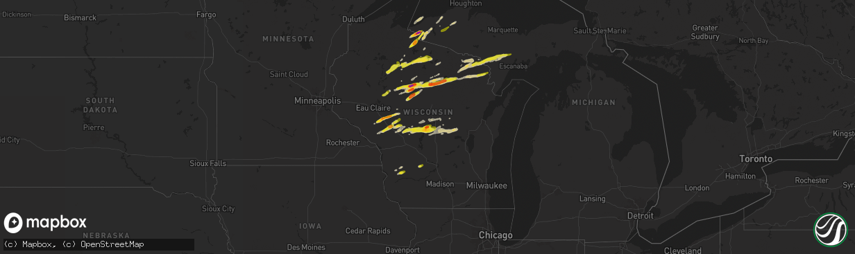
Hail Map on May 18, 2024
The weather event on May 18, 2024 includes Wind and Hail maps. 11 states and 308 cities were impacted and suffered possible damage. The total estimated number of properties impacted is 109,656.
Wind
Hail
109,656
Estimated number of impacted properties by a 1.00" hail or larger10,731
Estimated number of impacted properties by a 1.75" hail or larger0
Estimated number of impacted properties by a 2.50" hail or largerStates Impacted by Hail Map on May 18, 2024
Storm reports
Florida
| Date | Description |
|---|---|
| 05/18/20246:18 PM CDT | Social media report of several large tree branches and snapped trees as a severe thunderstorm moved through the area. Location is just south of where a weather station |
| 05/18/20245:47 PM CDT | Photos of quarter-sized hail at intersection of lantana and jog roads. |
| 05/18/20245:41 PM CDT | Social media report of quarter sized hail near lyons road and gulfstream preserve as a severe thunderstorm moved through the area. Time estimated via radar. |
| 05/18/20242:35 PM CDT | Ham radio relayed a report of downed trees and powerlines near the intersection of state road 44 and emeralda ave. |
| 05/18/20242:30 PM CDT | Trained spotter reports powerlines down and several trees down at the intersection of state road 44 and county road 473. |
| 05/18/202410:05 AM CDT | Trees down near tiller rd and owens pond rd. |
| 05/18/20249:34 AM CDT | Trees down across waterberry ln. |
| 05/18/20248:57 AM CDT | Corrects time of previous tstm wnd dmg report from 3 e jacobs. Trees down across jacob rd. |
| 05/18/20248:55 AM CDT | Corrects time of previous tstm wnd dmg report from 2 wnw bradford. Trees down near tiller rd and owens pond rd. |
| 05/18/20248:49 AM CDT | Trees down across jacob rd. |
| 05/18/20248:00 AM CDT | Report from the public on social media of several trees down on paved roads in the walton county portion of ponce de leon. |
| 05/18/20247:26 AM CDT | Multiple trees down across the road. |
Nebraska
| Date | Description |
|---|---|
| 05/18/20246:33 AM CDT | Report from mping: quarter |
| 05/18/20246:09 AM CDT | Large tree branches down. |
Virginia
| Date | Description |
|---|---|
| 05/18/20246:29 PM CDT | The smyth county 911 center reported that a tree was down on plum creek road just west of va highway 107 on the northwest side of chilhowie the road was partially block |
| 05/18/20243:03 PM CDT | Trees down on breezy rich road. |
Michigan
| Date | Description |
|---|---|
| 05/18/20246:44 PM CDT | Facebook report with picture of 1 hail from calumet. Time estimated by radar. Size estimated by reporter. |
| 05/18/20246:39 PM CDT | Media partner forwarded photo of hailstones estimated to be quarter-sized. Time estimated by radar. |
| 05/18/20245:20 PM CDT | Hail lasted 5-10 minutes. |
| 05/18/20245:06 PM CDT | Picture received showing hailstones larger than a quarter. Time estimated by radar. |
| 05/18/20245:00 PM CDT | Report via twitter of 1.5 and 2 inch hail on a measuring tape. Measured after the storm had passed. |
| 05/18/20244:57 PM CDT | Social media reports with pictures and videos of large hailstones. Time estimated by radar and size estimated by photos. |
| 05/18/20244:52 PM CDT | Picture via facebook of two large hailstones next to a quarter. Time estimated by radar. |
| 05/18/20244:52 PM CDT | Report from mping: half dollar |
| 05/17/20248:51 PM CDT | A local report indicates 1.00 inch wind near 2 ESE Kingsford |
Wisconsin
| Date | Description |
|---|---|
| 05/18/20246:38 PM CDT | Corrects previous hail report from 2 se port edwards. Report from mping: quarter |
| 05/18/20246:12 PM CDT | Tree branches down. |
| 05/18/20245:55 PM CDT | Wsaw-tv relayed report of 1 inch hail in irma. |
| 05/18/20245:48 PM CDT | A local report indicates 1.00 inch wind near 2 SE Goodrich |
| 05/18/20245:48 PM CDT | 2 facebook reports of hail around golf ball size near irma. One had a picture with the largest hailstone next to a ruler. Hail lasted up to 20 minutes. At one location. |
| 05/18/20245:35 PM CDT | A local report indicates 1.00 inch wind near Arbor Vitae |
| 05/18/20245:30 PM CDT | A local report indicates 1.00 inch wind near 2 N Dorchester |
| 05/18/20245:25 PM CDT | A local report indicates 1.25 inch wind near Woodruff |
| 05/18/20245:22 PM CDT | At lighthouse resort on fence lake. Wind gusts estimated at 50 mph. |
| 05/18/20245:19 PM CDT | Size was determined from a picture on waow facebook. |
| 05/18/20245:15 PM CDT | A local report indicates 1.00 inch wind near 4 SW Lac Du Flambeau |
| 05/18/20245:06 PM CDT | A local report indicates 1.25 inch wind near 1 SSE Rib Lake |
| 05/18/20244:54 PM CDT | Hailed for about 1 minute. |
| 05/18/20244:47 PM CDT | Public report of hail ranging from quarter to golf ball sized hail on pine lake in central iron county. |
| 05/18/20244:37 PM CDT | A local report indicates 1.00 inch wind near Rib Lake |
| 05/18/20244:19 PM CDT | Corrects previous hail report from chelsea. Size was determined from a picture on waow facebook. |
| 05/18/20244:10 PM CDT | Public estimated hail the size of a quarter on the southwest side of lac sault dore. |
| 05/18/20244:10 PM CDT | Public estimated hail the size of a quarter on t |
| 05/18/20244:06 PM CDT | A local report indicates 1.00 inch wind near 1 E Blair |
| 05/18/20244:03 PM CDT | Trained spotter reported hail between 1 inch and 1.5 inches in diameter coating the ground. |
| 05/18/20243:58 PM CDT | Quarter sized hail reported. |
| 05/18/20243:54 PM CDT | A local report indicates 1.50 inch wind near 7 WNW Humbird |
| 05/18/20243:34 PM CDT | Half dollar to golf ball size hail. |
| 05/18/20243:08 PM CDT | Time estimated based on radar. Spotter also reported gusty winds but no large branches were down. |
| 05/17/20249:15 PM CDT | Facebook report of 1 inch diameter hail near weyauwega. |
| 05/17/20248:03 PM CDT | A local report indicates 1.00 inch wind near 2 SW Beecher |
| 05/17/20247:38 PM CDT | Report from mping: quarter |
| 05/17/20247:19 PM CDT | A local report indicates 1.00 inch wind near Boaz |
| 05/17/20247:10 PM CDT | A local report indicates 1.25 inch wind near 4 SW Bosstown |
| 05/17/20247:04 PM CDT | Portage county emergency manager reported 1 inch hail in wisconsin rapids. |
| 05/17/20247:03 PM CDT | Trained spotter reported quarter inch hail along with an estimated 70 mph wind gusts. Report of a tree sown over the road. |
| 05/17/20247:03 PM CDT | Trained spotter |
| 05/17/20247:00 PM CDT | Trained spotter reported 1 inch hail. Location estimated. |
| 05/17/20247:00 PM CDT | 2 facebook reports of golf ball size hail on the south side of wisconsin rapids. Pictures available. Dents on vehicles reported. |
North Carolina
| Date | Description |
|---|---|
| 05/18/20244:00 PM CDT | Tree down. |
| 05/18/20244:00 PM CDT | Trees down along fall creek school road. |
| 05/18/20244:00 PM CDT | Several trees down in town. |
| 05/18/20243:55 PM CDT | Thunderstorm winds blew down one tree near the intersection of flat rock road and lake meadows drive. |
| 05/18/20243:50 PM CDT | 3 trees down. 1 at the wilkesboro speedway and 2 in wilkesboro. Several tents were also blown down at the racetrack. |
| 05/18/20243:16 PM CDT | Thunderstorm winds blew down one tree near the 600 block of chandler road. |
| 05/18/20243:13 PM CDT | Thunderstorm winds blew down one tree near the intersection of cody trail and garden ridge lane. |
| 05/18/20242:17 PM CDT | The surry county 911 center reported that a tree was down near the intersection of haystack road and devotion estate way near the town of devotion. The downed tree was |
| 05/18/20241:56 PM CDT | The wilkes county emergency manager reported a small confined area in which several trees were twisted... Blown over... Or otherwise damaged... Including some embedded |
Tennessee
| Date | Description |
|---|---|
| 05/18/20245:12 PM CDT | Tree down. |
| 05/18/20245:10 PM CDT | Tree down. |
Alabama
| Date | Description |
|---|---|
| 05/18/20245:05 PM CDT | Trees uprooted and fell on four homes in millbrook. Two homes damaged on bibb drive... One home on live oaks drive... And one home on graff road. |
| 05/18/20243:45 PM CDT | Social media report of a large tree snapped along forrest dr in springville. |
| 05/18/20243:41 PM CDT | Power lines down along will keith rd at weems rd. |
| 05/18/20243:31 PM CDT | Relayed through social media... Power poles broken on highway 75 near blount/jefferson county line. |
| 05/18/20243:28 PM CDT | Social media images of trees down across old tennessee pike rd and across highway 75 at blount/jefferson county line. |
| 05/18/20243:18 PM CDT | Social media video of quarter-size hail near kimberly. |
| 05/18/20243:12 PM CDT | Several trees were downed along mosley loop rd... Bone dry rd... And bradford tafford rd east of kimberly. |
| 05/18/20243:11 PM CDT | Two large trees were knocked down onto cr 67 about 3/4 miles west of highway 35. Time estimated by radar. |
| 05/18/20248:46 AM CDT | Trees down across the road. |
| 05/18/20248:33 AM CDT | Tree down on county rd 14 and county rd 79. |
| 05/18/20248:30 AM CDT | Tree down across holman dr. |
| 05/18/20248:25 AM CDT | Numerous trees reported down across slocomb. |
| 05/18/20248:25 AM CDT | Trees reported down and impacting homes. Time estimated by radar. |
| 05/18/20248:20 AM CDT | Numerous trees reported down across hartford. |
| 05/18/20248:09 AM CDT | Damage reported to a carport. |
| 05/18/20248:07 AM CDT | Numerous trees reported down across black. |
| 05/18/20248:00 AM CDT | Tree down on county rd 38 and county rd 104. |
| 05/17/20247:46 PM CDT | Trees down near coosada. |
| 05/17/20247:44 PM CDT | A few trees were blown down between coosada and millbrook. |
| 05/17/20247:44 PM CDT | A few trees were blown |
| 05/17/20247:42 PM CDT | A local report indicates 62 MPH wind near 3 W Wetumpka Muni Airpo |
| 05/17/20247:40 PM CDT | Numerous trees down on several roadways in the millbrook area. |
| 05/17/20247:33 PM CDT | A few trees and power lines down along cr 85 southeast of pine level. |
| 05/17/20247:28 PM CDT | Trees down on cedar ridge loop and cr 107 in pine level. |
Colorado
| Date | Description |
|---|---|
| 05/17/20248:54 PM CDT | Reported via social media. |
| 05/17/20248:53 PM CDT | Asos station klhx la junta airport on saturday may 18th... 2024. |
Cities Impacted by Hail Map on May 18, 2024
- Pensacola, FL
- Magnolia Springs, AL
- Loxley, AL
- Elberta, AL
- Silverhill, AL
- Foley, AL
- Robertsdale, AL
- Gulf Shores, AL
- Daphne, AL
- Lillian, AL
- Fairhope, AL
- Bon Secour, AL
- Summerdale, AL
- Orange Beach, AL
- Baker, FL
- Crestview, FL
- Russellville, AL
- Mount Hope, AL
- Moulton, AL
- Aberdeen, MS
- Hamilton, MS
- Danville, AL
- Hartselle, AL
- Deland, FL
- Okahumpka, FL
- Lake Helen, FL
- Leesburg, FL
- Altoona, FL
- Umatilla, FL
- Houston, MS
- Okolona, MS
- Grand Island, FL
- Tavares, FL
- Madison, NC
- Reidsville, NC
- Groveoak, AL
- Langston, AL
- Guntersville, AL
- Vero Beach, FL
- Summerfield, NC
- Cornell, WI
- Cadott, WI
- Gardendale, AL
- Warrior, AL
- Fyffe, AL
- Section, AL
- Galax, VA
- Paisley, FL
- Strum, WI
- Whitehall, WI
- Morris, AL
- Kimberly, AL
- Pinson, AL
- Fort McCoy, FL
- Osseo, WI
- Independence, WI
- Fort Pierce, FL
- Pierson, FL
- Boyd, WI
- Holcombe, WI
- Gilman, WI
- Ladysmith, WI
- Winter, WI
- Medford, WI
- De Leon Springs, FL
- Remlap, AL
- Gordo, AL
- Trafford, AL
- Ormond Beach, FL
- Astor, FL
- Bunnell, FL
- Phillips, WI
- Saint Cloud, FL
- Fairchild, WI
- Buhl, AL
- Melbourne Beach, FL
- Springville, AL
- Augusta, WI
- Willard, WI
- Blair, WI
- Taylor, WI
- Black River Falls, WI
- Park Falls, WI
- Fosters, AL
- Tuscaloosa, AL
- Ralph, AL
- Hixton, WI
- Ettrick, WI
- Hayden, AL
- Kennan, WI
- Westboro, WI
- Merrillan, WI
- Alma Center, WI
- Lublin, WI
- Neillsville, WI
- Butternut, WI
- Rib Lake, WI
- Montreal, WI
- Fifield, WI
- Duncanville, AL
- Lincoln, AL
- Rogersville, TN
- Withee, WI
- Greenwood, WI
- Merrill, WI
- Mercer, WI
- Hurley, WI
- Bessemer, MI
- Eastaboga, AL
- Anniston, AL
- Wakefield, MI
- Ironwood, MI
- Ontonagon, MI
- Humbird, WI
- Greeneville, TN
- Lac Du Flambeau, WI
- Minocqua, WI
- Nisula, MI
- Mass City, MI
- Loxahatchee, FL
- Iron Belt, WI
- Ramsay, MI
- Tomahawk, WI
- Woodruff, WI
- Wellington, FL
- Bergland, MI
- Marenisco, MI
- Dorchester, WI
- Curtiss, WI
- Pompano Beach, FL
- Pittsville, WI
- Lake Worth, FL
- Gile, WI
- Stetsonville, WI
- Abbotsford, WI
- Athens, WI
- Irma, WI
- Ewen, MI
- Bruce Crossing, MI
- Warrens, WI
- Gleason, WI
- Coral Springs, FL
- Sylacauga, AL
- Babcock, WI
- Ranburne, AL
- Hobe Sound, FL
- Manitowish Waters, WI
- Boynton Beach, FL
- Goodwater, AL
- Palm Beach, FL
- Lake Worth Beach, FL
- Elcho, WI
- Wisconsin Rapids, WI
- Nekoosa, WI
- Necedah, WI
- Pelican Lake, WI
- Summit Lake, WI
- Deerbrook, WI
- Pearson, WI
- Port Edwards, WI
- Calumet, MI
- Hancock, MI
- Bancroft, WI
- Rhinelander, WI
- Crandon, WI
- Gays Mills, WI
- Soldiers Grove, WI
- Blue River, WI
- Pickerel, WI
- Lake Tomahawk, WI
- Viola, WI
- Richland Center, WI
- Muscoda, WI
- Plainfield, WI
- Almond, WI
- Laona, WI
- Wabeno, WI
- Prattville, AL
- Athelstane, WI
- Deatsville, AL
- Eclectic, AL
- Booth, AL
- Millbrook, AL
- Coosada, AL
- Argonne, WI
- Waupaca, WI
- Tallassee, AL
- Stevens Point, WI
- Brantwood, WI
- Amberg, WI
- Pembine, WI
- Florence, WI
- Fence, WI
- Ogema, WI
- Prentice, WI
- Armstrong Creek, WI
- Dunbar, WI
- Wild Rose, WI
- Long Lake, WI
- Reedsburg, WI
- Loganville, WI
- Goodman, WI
- Custer, WI
- Arcadia, WI
- Rock Springs, WI
- Niagara, WI
- Kingsford, MI
- Iron Mountain, MI
- Hasty, CO
- McClave, CO
- West Palm Beach, FL
- Plover, WI
- Amherst, WI
- Quinnesec, MI
- Wiley, CO
- Norway, MI
- Pine River, WI
- Vulcan, MI
- Weyauwega, WI
- Haswell, CO
- Eads, CO
- Hermansville, MI
- Foster City, MI
- Perronville, MI
- Arlington, CO
- Lamar, CO
- Bark River, MI
- Las Animas, CO
- Fremont, WI
- New London, WI
- Cornell, MI
- Granada, CO
- Little Lake, MI
- Rock, MI
- Holly, CO
- Toxey, AL
- Butler, AL
- Bird City, KS
- Coolidge, KS
- Syracuse, KS
- Marienthal, KS
- Holcomb, KS
- Scott City, KS
- Healy, KS
- Everglades City, FL
- Atwood, KS
- Colby, KS
- Selden, KS
- Stratton, NE
- Benkelman, NE
- York, NE
- Herndon, KS
- Culbertson, NE
- Trenton, NE
- Ludell, KS
- Benedict, NE
- Waco, NE
- Max, NE
- Glasco, KS
- Delphos, KS
- Concordia, KS
- Oberlin, KS
- Stromsburg, NE
- Utica, NE
- Gresham, NE
- Staplehurst, NE
- Ulysses, NE
- Fairbury, NE
- Daykin, NE
- Rexford, KS
- Seward, NE
- Bee, NE
- Garland, NE
- Western, NE
- Swanton, NE
- Plymouth, NE
- Gem, KS
- McCook, NE
- Raymond, NE
- Malcolm, NE
- Valparaiso, NE
- Pleasant Dale, NE
- Lincoln, NE
- Jansen, NE
- Canton, KS
- Davey, NE
- Waverly, NE
- Palisade, NE
- Jetmore, KS
- Alvo, NE
- Greenwood, NE
- Eagle, NE
- Syracuse, NE
- Otoe, NE
- Avoca, NE
- Unadilla, NE
- Murdock, NE
- Ashland, NE
- Weeping Water, NE
- Manley, NE
- Elmwood, NE
- Louisville, NE
- Iola, WI
- Arpin, WI
- Rudolph, WI
- Vesper, WI
- Hancock, WI
- Junction City, WI