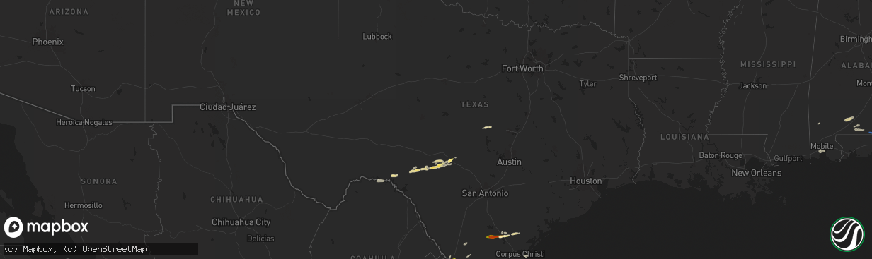
Hail Map in Texas on May 17, 2024
The weather event in Texas on May 17, 2024 includes Hail, Wind, and Tornado maps. 15 states and 195 cities were impacted and suffered possible damage. The total estimated number of properties impacted is 59,673.
Hail
Wind
Tornado
59,673
Estimated number of impacted properties by a 1.00" hail or larger10,733
Estimated number of impacted properties by a 1.75" hail or larger0
Estimated number of impacted properties by a 2.50" hail or largerStorm reports in Texas
Texas
| Date | Description |
|---|---|
| 05/17/20249:00 AM CDT | Quarter sized hail reported by a resident. |
| 05/17/20248:45 AM CDT | Various photos and reports on social media showing 1 inch hail across portions of laredo. |
| 05/17/20248:04 AM CDT | A few golfball sized stones than hail sized dropped a bit smaller...size unknown. Lasted between 10 and 15 minutes. |
| 05/17/20247:56 AM CDT | Quarter to ping-pong ball sized hail near intersection of mccoll and military highway...us 281. Duration of hail was fourteen minutes. |
| 05/17/20247:30 AM CDT | Former cooperative observer reported quarter sized hail briefly covering the ground just south of the intersection of 7 mile and n. Doffing road in citrus city. Time es |
| 05/17/20247:25 AM CDT | Quarter sized hail briefly covered the ground in the vicinity of doffing rd. And conway ave. In north mission. |
| 05/17/20247:25 AM CDT | Quarter sized hail near intersection of tom gill and 3 mile line road. Duration was 5 minutes. Video evidence provided. |
| 05/17/20247:23 AM CDT | Video showed quarter-sized hail near intersection of la homa road and mile 7 road north of mission. Time and duration estimated by radar. |
| 05/17/20247:15 AM CDT | Video showed hail-dominant precipitation along p.j. Garza road near e. Expressway 83. |
| 05/17/20247:14 AM CDT | Social media photos of quarter size hail in swinney switch. Time estimated from radar. |
| 05/17/20247:08 AM CDT | Photo of quarter size hail in dinero. Time estimated from radar. |
| 05/16/20249:07 PM CDT | A local report indicates 1.00 inch wind near 5 NNE Devil's Sinkhole |
All States Impacted by Hail Map on May 17, 2024
Cities Impacted by Hail Map on May 17, 2024
- Mathis, TX
- Encinal, TX
- George West, TX
- Sandia, TX
- Rio Grande City, TX
- Laredo, TX
- Beeville, TX
- Hebbronville, TX
- La Joya, TX
- Skidmore, TX
- Penitas, TX
- Mission, TX
- Sullivan City, TX
- San Ygnacio, TX
- Zapata, TX
- Encino, TX
- Woodsboro, TX
- Hidalgo, TX
- Mcallen, TX
- Pharr, TX
- Realitos, TX
- Donna, TX
- San Juan, TX
- Alamo, TX
- Weslaco, TX
- Falfurrias, TX
- Concepcion, TX
- Premont, TX
- Riviera, TX
- Kingsville, TX
- Corpus Christi, TX
- Billings, MT
- Mercedes, TX
- Edinburg, TX
- Progreso, TX
- Brockton, MT
- Lambert, MT
- Fairview, MT
- Curran, MI
- Stanley, ND
- Brewton, AL
- Bad Axe, MI
- Sidney, MT
- Saginaw, MI
- Kenmare, ND
- Culbertson, MT
- Andalusia, AL
- Cartwright, ND
- Bruni, TX
- Mott, ND
- New Leipzig, ND
- Calliham, TX
- Alexander, ND
- Center, ND
- Elgin, ND
- Florala, AL
- Laurel Hill, FL
- Lockhart, AL
- Defuniak Springs, FL
- Arnegard, ND
- Watford City, ND
- Mohall, ND
- Antler, ND
- Maxbass, ND
- Westhope, ND
- Newburg, ND
- Souris, ND
- Samson, AL
- Silverwood, MI
- Mayville, MI
- Ekalaka, MT
- Columbiaville, MI
- Otter Lake, MI
- Caro, MI
- Kingston, MI
- Deford, MI
- Mobile, AL
- Keene, ND
- Theodore, AL
- Lapeer, MI
- Cosmos, MN
- Camp Crook, SD
- Buffalo, SD
- Ludlow, SD
- Brusett, MT
- Sand Springs, MT
- Jordan, MT
- Cohagen, MT
- Hettinger, ND
- Litchfield, MN
- Atwater, MN
- Grove City, MN
- Bird Island, MN
- Fostoria, MI
- Millington, MI
- Carson, ND
- Davison, MI
- Geneva, AL
- Olivia, MN
- Denhoff, ND
- Lodgepole, SD
- Ralph, SD
- Bowman, ND
- Flasher, ND
- Hector, MN
- Bonifay, FL
- Gerald, MO
- Flint, MI
- Lemmon, SD
- Mandaree, ND
- New Town, ND
- Parshall, ND
- Sullivan, MO
- Rosebud, MO
- Remer, MN
- Shepherd, MT
- Grand Blanc, MI
- Goodrich, MI
- Atlas, MI
- Swatara, MN
- Hill City, MN
- Eveleth, MN
- Metamora, MI
- Saint Anthony, ND
- Graceville, FL
- Scranton, ND
- Reeder, ND
- Fairfax, MN
- Gibbon, MN
- Selfridge, ND
- Meigs, GA
- Pelham, GA
- Meadow, SD
- Holly, MI
- Marianna, FL
- Cottondale, FL
- Campbellton, FL
- Ortonville, MI
- Morristown, SD
- Keldron, SD
- Greenwood, FL
- Rolla, MO
- Rocksprings, TX
- Wheeler, MI
- Ithaca, MI
- Ozark, AR
- Junction, TX
- Comstock, TX
- Mulberry, AR
- Grand Ridge, FL
- Moultrie, GA
- Berlin, GA
- Ray City, GA
- Lakeland, GA
- Nashville, GA
- Vassar, MI
- Fenton, MI
- Del Rio, TX
- Lancaster, MN
- Lake Bronson, MN
- Gillette, WY
- Mountain Home, TX
- Palermo, ND
- Berthold, ND
- Moorcroft, WY
- Saint George, GA
- Hilliard, FL
- Callahan, FL
- Lometa, TX
- San Saba, TX
- Lampasas, TX
- Hope Hull, AL
- Montgomery, AL
- McIntosh, AL
- Helena, AR
- Dundee, MS
- Hoxie, AR
- Repton, AL
- Walnut Ridge, AR
- Marianna, AR
- Castleberry, AL
- Lenox, AL
- Evergreen, AL
- Tunica, MS
- Somerville, TN
- Brickeys, AR
- Heth, AR
- Bono, AR
- Cut Off, LA
- Barataria, LA
- Hornsby, TN
- Selmer, TN
- Bethel Springs, TN
- Stantonville, TN
- Adamsville, TN


