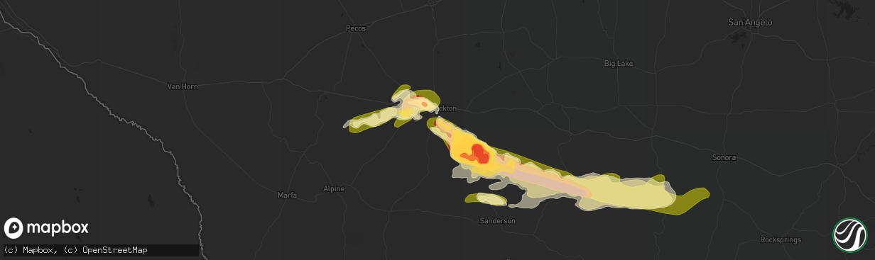
Hail Map in Fort Stockton, TX on May 4, 2024
The weather event in Fort Stockton, TX on May 4, 2024 includes Hail, Wind, and Tornado maps. 12 states and 410 cities were impacted and suffered possible damage. The total estimated number of properties impacted is 3,744.
Hail
Wind
Tornado
3,744
Estimated number of impacted properties by a 1.00" hail or larger147
Estimated number of impacted properties by a 1.75" hail or larger49
Estimated number of impacted properties by a 2.50" hail or largerStorm reports in Fort Stockton, TX
Fort Stockton, TX
| Date | Description |
|---|---|
| 05/04/20245:55 PM CDT | Report from mping: tennis ball |
| 05/04/20245:53 PM CDT | A local report indicates 3.00 inch wind near 26 NNE Longfellow |
| 05/04/20245:51 PM CDT | Report from mping: half dollar |
| 05/04/20245:22 PM CDT | A local report indicates 2.50 inch wind near 26 SE Fort Stockton |
| 05/04/20244:45 PM CDT | A local report indicates 2.50 inch wind near 21 SE Fort Stockton |
| 05/04/20244:45 PM CDT | A local report indicates 3.00 inch wind near 27 SE Fort Stockton |
| 05/04/20243:44 PM CDT | A local report indicates 1.75 inch wind near 6 W Fort Stockton |
| 05/04/20243:42 PM CDT | A local report indicates 1.00 inch wind near Belding |
| 05/04/20243:41 PM CDT | Estimated golf ball size hail caused extensive damage to a home near fort stockton. Hail may have been even larger. All windows and exterior walls facing hail were brok |
| 05/04/20243:41 PM CDT | Pecos county emergency management reported two snapped power poles near the base about 4 miles northwest on us highway 285 from fort stockton. Time is estimated from ra |
| 05/04/20243:41 PM CDT | Wind driven hail caused extensive damage to home. Windows broken... Power poles down... And exterior wall damage from hail and wind at location. Time estimated from rad |
| 05/04/20243:35 PM CDT | A local report indicates 1.00 inch wind near 8 NNW Belding |
All States Impacted by Hail Map on May 4, 2024
All Cities Impacted by Hail Map on May 4, 2024
- Elgin, OK
- Fletcher, OK
- Pleasant Hope, MO
- Buffalo, MO
- Fair Grove, MO
- Marble Falls, AR
- Harrison, AR
- Western Grove, AR
- Everton, AR
- Pindall, AR
- Saint Joe, AR
- Marshall, AR
- Leslie, AR
- Gilbert, AR
- Harriet, AR
- Witter, AR
- Woodville, TX
- Pettigrew, AR
- Timbo, AR
- Deer, AR
- Greenbrier, AR
- Fairfield Bay, AR
- Quitman, AR
- Mount Vernon, AR
- Mayo, FL
- Live Oak, FL
- Heber Springs, AR
- Rose Bud, AR
- Ira, TX
- El Paso, AR
- Romance, AR
- Fluvanna, TX
- Beebe, AR
- Searcy, AR
- Locust Grove, AR
- Batesville, AR
- Floral, AR
- Snyder, TX
- Gail, TX
- McRae, AR
- Roscoe, TX
- Pangburn, AR
- Salem, MO
- Sweetwater, TX
- Bunker, MO
- Asher, OK
- Rebecca, GA
- Centerville, MO
- Ty Ty, GA
- Sumner, GA
- Rockfield, KY
- Auburn, KY
- Maud, OK
- Konawa, OK
- Bowling Green, KY
- Black, MO
- Cheraw, SC
- Youngstown, FL
- Bixby, MO
- Mentone, TX
- Fort Stockton, TX
- Chula, GA
- Tifton, GA
- Robert Lee, TX
- Byromville, GA
- Balmorhea, TX
- Omega, GA
- Benton, AR
- Blackwell, TX
- Wingate, TX
- Hensley, AR
- Hardin, IL
- Batchtown, IL
- Fieldon, IL
- Moultrie, GA
- Rose, OK
- Omaha, AR
- Bronte, TX
- Canton, IL
- Cuba, IL
- Ada, OK
- Fort Davis, TX
- Norman Park, GA
- Kermit, TX
- Redfield, AR
- Mount Sterling, IL
- Jal, NM
- Colcord, OK
- Huntsville, AR
- Stonewall, OK
- Eldred, IL
- Smithfield, IL
- Sheridan, AR
- Imperial, TX
- Tuscola, TX
- Lead Hill, AR
- Siloam Springs, AR
- Allen, OK
- Tupelo, OK
- Carrollton, IL
- Camilla, GA
- Bainbridge, GA
- Colquitt, GA
- Barney, GA
- Pecos, TX
- Yellville, AR
- Pecatonica, IL
- Durand, IL
- Springdale, AR
- Merkel, TX
- Success, MO
- Plato, MO
- Roby, MO
- Saint Peters, MO
- Ovalo, TX
- Lawn, TX
- Climax, GA
- Gentry, AR
- Monahans, TX
- Barstow, TX
- Pavo, GA
- Hot Springs Village, AR
- Farmington, AR
- Prairie Grove, AR
- Milton, WI
- Hot Springs National Park, AR
- Wink, TX
- Bauxite, AR
- Cabool, MO
- Mountain Grove, MO
- Coalgate, OK
- Hindsville, AR
- Arenzville, IL
- Licking, MO
- Odessa, TX
- Lonsdale, AR
- Winnebago, IL
- Dixie, GA
- Boston, GA
- Barwick, GA
- Whitewater, WI
- Fort Atkinson, WI
- Thomasville, GA
- Abilene, TX
- Houston, MO
- Fayetteville, AR
- Cairo, GA
- Lonedell, MO
- Grubville, MO
- Virginia, IL
- Beardstown, IL
- Pittsburg, OK
- Oconomowoc, WI
- Ochlocknee, GA
- Rockton, IL
- Rockford, IL
- Sullivan, WI
- Wardville, OK
- Goldsmith, TX
- Piasa, IL
- Brighton, IL
- Luebbering, MO
- Dittmer, MO
- Winters, TX
- Havana, IL
- Brinson, GA
- Godfrey, IL
- Alton, IL
- Hillsboro, MO
- Isabella, MO
- Thornfield, MO
- Fidelity, IL
- Jerseyville, IL
- Centrahoma, OK
- Wister, OK
- Watertown, WI
- Millstadt, IL
- Columbia, IL
- East Carondelet, IL
- Dupo, IL
- Saint Louis, MO
- Imperial, MO
- Goldsboro, TX
- Novice, TX
- Dow, IL
- Ixonia, WI
- Topeka, IL
- Barnhart, MO
- House Springs, MO
- Cedar Hill, MO
- Arnold, MO
- Belleville, IL
- Andrews, TX
- Antlers, OK
- Clayton, OK
- Pleasant Plains, IL
- Booneville, AR
- Valley Springs, AR
- Wilmar, AR
- Monticello, AR
- Justiceburg, TX
- Caledonia, MO
- Belleview, MO
- Belgrade, MO
- Crane, TX
- Warren, AR
- New Berlin, IL
- Clyde, TX
- Coleman, TX
- McCamey, TX
- Post, TX
- Snow, OK
- Whigham, GA
- Solo, MO
- Midland, TX
- Star City, AR
- Dermott, AR
- Brownwood, TX
- Bangs, TX
- Mena, AR
- Burkett, TX
- Sainte Genevieve, MO
- Bonne Terre, MO
- Waldron, AR
- Donalsonville, GA
- Jayton, TX
- Rattan, OK
- Rotan, TX
- Liberty, MS
- Coulterville, IL
- Midkiff, TX
- Dryden, TX
- Cross Plains, TX
- Bluffton, AR
- Magnolia, MS
- Aspermont, TX
- Morrisonville, IL
- Pinckneyville, IL
- Oakdale, IL
- Belleville, AR
- Danville, AR
- Dardanelle, AR
- Paint Rock, TX
- Eden, TX
- Millersview, TX
- Lake Village, AR
- O'Brien, TX
- Knox City, TX
- Nashville, IL
- Rochester, TX
- Briggsville, AR
- Hagarville, AR
- Broken Bow, OK
- Brookesmith, TX
- Valliant, OK
- Ringold, OK
- Rising Star, TX
- Big Lake, TX
- Garden City, TX
- Marquand, MO
- Patton, MO
- Brady, TX
- Richland Springs, TX
- Rochelle, TX
- May, TX
- Rowena, TX
- Ashley, IL
- Woodlawn, IL
- San Saba, TX
- Goldthwaite, TX
- Bethel, OK
- Early, TX
- Mullin, TX
- Santa Anna, TX
- Tamaroa, IL
- Voss, TX
- Hermleigh, TX
- Watson, OK
- Du Quoin, IL
- Van Horn, TX
- Salt Flat, TX
- Chattahoochee, FL
- Quincy, FL
- Amherst, TX
- Cove, AR
- Evant, TX
- Star, TX
- Doole, TX
- Gouldbusk, TX
- Copperas Cove, TX
- Gretna, FL
- Ballinger, TX
- Gatesville, TX
- Lampasas, TX
- Delaware, AR
- New Blaine, AR
- Estancia, NM
- Ozona, TX
- Priddy, TX
- Hamilton, TX
- Purmela, TX
- Bay Springs, MS
- Paducah, TX
- Jonesboro, TX
- Hereford, TX
- Sylvester, TX
- Hamlin, TX
- Kempner, TX
- Valley Mills, TX
- Comstock, TX
- Clifton, TX
- Oglesby, TX
- Anson, TX
- Lohn, TX
- McGregor, TX
- Crawford, TX
- Fort Hood, TX
- Franklin, TX
- Lometa, TX
- Weinert, TX
- Del Rio, TX
- Amarillo, TX
- Kosse, TX
- Mclean, TX
- Clarendon, TX
- Philpot, KY
- Moody, TX
- Arlington, TX
- Woodway, TX
- Lorena, TX
- Sonora, TX
- Shamrock, TX
- Thornton, TX
- Throckmorton, TX
- China Spring, TX
- Waco, TX
- Rockwood, TX
- Hollis, OK
- Rogers, TX
- Buckholts, TX
- Elm Mott, TX
- Mart, TX
- Calvert, TX
- Burlington, TX
- Hearne, TX
- Chilton, TX
- Riesel, TX
- Eldorado, TX
- Bremond, TX
- Anderson, TX
- Melvin, TX
- Navasota, TX
- College Station, TX
- Rocksprings, TX
- Lovelady, TX
- Bedias, TX
- Richards, TX
- Marquez, TX
- Normangee, TX
- Iola, TX
- Huntsville, TX
- Elk City, OK
- Hammon, OK
- Butler, OK
- Pennington, TX
- Crockett, TX
- Kennard, TX
- Groveton, TX
- New Waverly, TX
- Bryan, TX
- Buna, TX
- Apple Springs, TX
- Pointblank, TX
- Midway, TX
- Lufkin, TX
- Oakhurst, TX
- Coldspring, TX
- Trinity, TX
- Willis, TX
- Cleveland, TX
- North Zulch, TX
- Livingston, TX
- Onalaska, TX
- Huntington, TX
- Goodrich, TX
- Shepherd, TX
- Nash, OK
- Jet, OK
- Saratoga, TX
- Liberty, TX
- Camp Wood, TX
- Barksdale, TX
- Hull, TX
- Warren, TX
- Leakey, TX
- Batson, TX
- Kountze, TX
- Sour Lake, TX
- Lumberton, TX
- Beaumont, TX
- Stringtown, OK
- Brenham, TX
- Weimar, TX
- La Grange, TX
- Washington, TX
- Columbus, TX
- Garwood, TX
- Eagle Lake, TX
- East Bernard, TX
- Grady, AR


