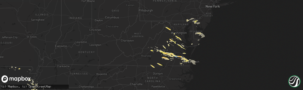
Hail Map in Virginia on June 16, 2023
The weather event in Virginia on June 16, 2023 includes Wind, Hail, and Tornado maps. 22 states and 1,029 cities were impacted and suffered possible damage. The total estimated number of properties impacted is 150,309.
Wind
Hail
Tornado
150,309
Estimated number of impacted properties by a 1.00" hail or larger7,009
Estimated number of impacted properties by a 1.75" hail or larger0
Estimated number of impacted properties by a 2.50" hail or largerStorm reports in Virginia
Virginia
| Date | Description |
|---|---|
| 06/16/20236:25 PM CDT | A local report indicates 1.00 inch wind near MINERAL |
| 06/16/20236:24 PM CDT | Report via mping. |
| 06/16/20236:15 PM CDT | A local report indicates 1.00 inch wind near TAPPAHANNOCK |
| 06/16/20235:00 PM CDT | Photo on social media from broadcast media. |
| 06/16/20234:45 PM CDT | Mping report of 1 inch hail near lake monticello. |
| 06/16/20234:38 PM CDT | A local report indicates 1.00 inch wind near 2 NW HOLLAND |
| 06/16/20234:38 PM CDT | A local report indicates 1.00 inch wind near 4 NNW VIRGINIA BEACH OC |
| 06/16/20234:37 PM CDT | Hail lasted for 15 minutes. |
| 06/16/20234:35 PM CDT | Corrects previous tstm wnd dmg report from 1 e nahor. Multiple trees knocked down near lake monticello. Time estimated from radar. |
| 06/16/20234:32 PM CDT | Multiple trees knocked down near lake monticello. Time estimated from radar. |
| 06/16/20234:32 PM CDT | Quarter size hail was reported in clifton. |
| 06/16/20234:27 PM CDT | A local report indicates 1.00 inch wind near 1 WSW Brookfield |
| 06/16/20234:27 PM CDT | A local report indicates 1.00 inch wind near 1 SSE OCEAN VIEW |
| 06/16/20234:27 PM CDT | Inches from the caledonia area. |
| 06/16/20234:25 PM CDT | Picture of quarter sized hail in wayne creek area of norfolk. |
| 06/16/20234:25 PM CDT | A local report indicates 1.00 inch wind near 1 W Fredericksburg |
| 06/16/20234:19 PM CDT | Ngu site reported a 53kt gust. |
| 06/16/20234:19 PM CDT | A local report indicates 1.00 inch wind near 2 SE Centreville |
| 06/16/20234:18 PM CDT | Tree down on the 3000 block of plank road |
| 06/16/20234:16 PM CDT | Large branches snapped in multiple locations between centreville and clifton. Piece of fascia peeled outward from home. |
| 06/16/20234:15 PM CDT | Quarter size hail near wards corner. Video from social media. |
| 06/16/20234:10 PM CDT | Quarter size hail reported at orcutt ave. |
| 06/16/20234:03 PM CDT | Numerous trees down across southern newport news. Winds of 83 mph measured at the jrb. |
| 06/16/20234:00 PM CDT | Corrects previous tstm wnd dmg report from 3 ene carrollton -- vadot station on james river bridge reported 72kt gust. |
| 06/16/20234:00 PM CDT | Vadot station on james river bridge reported 72kt gust. |
| 06/16/20233:58 PM CDT | Trees down in hilton village. |
| 06/16/20233:55 PM CDT | A local report indicates 1.00 inch wind near 1 W Dunavant |
| 06/16/20233:55 PM CDT | Public reports rain wrapped tornado in carrolton. |
| 06/16/20233:41 PM CDT | Twitter video of half-dollar to golf ball-sized hailstones bouncing off the grass. |
| 06/16/20233:19 PM CDT | Tree tops snapped off on marina drive. Report via twitter. Time estimated from radar. |
| 06/16/20233:15 PM CDT | A local report indicates 1.25 inch wind near E SUTHERLAND |
| 06/16/20233:15 PM CDT | Picture of 2 inch hail at pipsico scout reservation. Time estimated. |
| 06/16/20233:13 PM CDT | Report via facebook. Time estimated from radar. |
| 06/16/20233:12 PM CDT | A local report indicates 1.00 inch wind near 1 WNW Round Hill |
| 06/16/20233:12 PM CDT | A local report indicates 1.50 inch wind near 1 NE Bluemont |
| 06/16/20233:05 PM CDT | Video of quarter and half dollar sized hail on social media. |
| 06/16/20233:05 PM CDT | Video of quarter and half dollar sized hail on social media. |
| 06/16/20233:00 PM CDT | Report of multiple trees down in the hungarytown road area. |
| 06/16/20232:58 PM CDT | Trees down in the vicinity of rodophil road and route 620. All lanes are closed. |
| 06/16/20232:57 PM CDT | Trees down along highway 460 at disputanta. |
| 06/16/20232:56 PM CDT | Quarter-sized hail estimated |
| 06/16/20232:56 PM CDT | A local report indicates 1.00 inch wind near 2 NE Berryville |
| 06/16/20232:50 PM CDT | Extensive tree damage off of rodophil rd. Multiple large limbs knocked down as well. Time estimated from radar. |
| 06/16/20232:48 PM CDT | Extensive wind damage including roof damage to barn/outbuildings and an overturned semi-trailer. In addition... Numerous trees and large limbs knocked down. Time estima |
| 06/16/20232:40 PM CDT | Corrects previous tstm wnd dmg report from 4 e south boston. Tree down from thunderstorm winds. Hail reported as well... But size unknown. |
| 06/16/20232:40 PM CDT | Corrects previous tstm wnd dmg report from 4 e south boston. Tree down from thunderstorm winds. Hail reported as well... But size unknown. |
| 06/16/20232:35 PM CDT | Numerous trees down along portions of route 45 from the cumberland courthouse south to farmville |
| 06/16/20232:31 PM CDT | One tree down near the intersection of berry hill road and river road on the west side of south boston. |
| 06/16/20232:31 PM CDT | One tree down near the intersection of berry hill road and river road on the west side of south boston. |
| 06/16/20232:30 PM CDT | Large tree blocking the road. |
| 06/16/20232:30 PM CDT | A few limbs down. Hail from pea size to about 1 inch. |
| 06/16/20232:29 PM CDT | A local report indicates 1.00 inch wind near GREEN BAY |
| 06/16/20232:29 PM CDT | Shed blown over. Time estimated from radar. |
| 06/16/20232:28 PM CDT | Tree down in the city of south boston. |
| 06/16/20232:28 PM CDT | Tree down on the north side of south boston. |
| 06/16/20232:28 PM CDT | Tree down on the north side of south boston. |
| 06/16/20232:28 PM CDT | Tree down in the city of south boston. |
| 06/16/20232:26 PM CDT | Corrects previous tstm wnd dmg report from 2 nne south boston. Tree down on the north side of south boston. |
| 06/16/20232:26 PM CDT | Corrects previous tstm wnd dmg report from 2 nne south boston. Two trees down near the intersection of hamilton boulevard and halifax road just northwest of the city of |
| 06/16/20232:26 PM CDT | Corrects previous tstm wnd dmg report from 2 nne south boston. Tree down on the north side of south boston. |
| 06/16/20232:23 PM CDT | Trees down along route 630 at mica dr and route 721. All lanes blocked. |
| 06/16/20232:22 PM CDT | Thunderstorm winds blew out a window at the danville regional hospital. |
| 06/16/20232:22 PM CDT | Wset relayed a report from a viewer of considerable wind damage to trees in the westover hills area on the west side of danville. Several trees fell on homes causing st |
| 06/16/20232:22 PM CDT | Thunderstorm winds blew out a window at the danville regional hospital. |
| 06/16/20232:22 PM CDT | Wset relayed a report from a viewer of considerable wind damage to trees in the westover hills area on the west side of danville. Several trees fell on homes causing st |
| 06/16/20232:21 PM CDT | A couple of trees down in ballou park. |
| 06/16/20232:21 PM CDT | A couple of trees down in ballou park. |
| 06/16/20232:20 PM CDT | Tree down blocking interstate. |
| 06/16/20232:20 PM CDT | Several trees down near w. Main street. |
| 06/16/20232:20 PM CDT | Several trees down near w. Main street. |
| 06/16/20232:18 PM CDT | Tree down across route 752 in the vicinity of river road. |
| 06/16/20232:17 PM CDT | Tree down at the intersection of e james anderson hwy and whetstone lane. |
| 06/16/20232:17 PM CDT | Tree down at the intersection of e james anderson hwy and whetstone lane. |
| 06/16/20232:15 PM CDT | Thunderstorm winds blew down a tree along the 900 block of andersonville road. |
| 06/16/20232:15 PM CDT | Thunderstorm winds blew down a tree along the 900 block of andersonville road. |
| 06/16/20232:14 PM CDT | Tree down near andersonville road. |
| 06/16/20232:14 PM CDT | Tree down near andersonville road. |
| 06/16/20232:13 PM CDT | Tree down across route 669 in the vicinity of church road. |
| 06/16/20232:08 PM CDT | A local report indicates 1.00 inch wind near 2 WNW Buckingham |
| 06/16/20232:08 PM CDT | Hail up to the size of quarters fell at the courthouse in buckingham. |
| 06/16/20232:08 PM CDT | Hail up to the size of quarters fell at the courthouse in buckingham. |
| 06/16/20232:08 PM CDT | A local report indicates 1.00 inch wind near 2 WNW BUCKINGHAM |
| 06/16/20232:08 PM CDT | Hail up to the size of quarters fell at the courthouse in buckingham. |
| 06/16/20232:08 PM CDT | Hail up to the size of quarters fell at the courthouse in buckingham. |
| 06/16/20232:07 PM CDT | Numerous trees down near matoaca. Damage was reported as intense in an isolated area. |
| 06/16/20232:06 PM CDT | Tree down along oak hill road. |
| 06/16/20232:06 PM CDT | Tree down along oak hill road. |
| 06/16/20232:05 PM CDT | Tree knocked down and multiple large limbs down. Time estimated from radar. |
| 06/16/20232:05 PM CDT | Tree knocked d nc 3639 7912 trees down on lee chambers rd. |
| 06/16/20232:04 PM CDT | Trees down along thicket lane and route 4731. All lanes blocked. |
| 06/16/20232:00 PM CDT | A local report indicates 1.00 inch wind near 1 SW Norfolk Internatio |
| 06/16/20232:00 PM CDT | Tree down across route 4731 near deer thicket lane. |
| 06/16/20231:56 PM CDT | Thunderstorm winds blew down a tree on route 58 near the intersection with mountain valley road. |
| 06/16/20231:56 PM CDT | Thunderstorm winds blew down a tree on route 58 near the intersection with mountai |
| 06/16/20231:56 PM CDT | Thunderstorm winds blew down a tree on route 58 near the intersection with mountain valley road. |
| 06/16/20231:56 PM CDT | Tree uprooted. Time estimated from radar. |
| 06/16/20231:55 PM CDT | Thunderstorm winds blew down a tree near axton school road. |
| 06/16/20231:55 PM CDT | Tree down across taylor road. |
| 06/16/20231:55 PM CDT | Thunderstorm winds blew down a tree near axton school road. |
| 06/16/20231:50 PM CDT | Picture of quarter size hail along twelveoaks rd in chesterfield on social media. |
| 06/16/20231:49 PM CDT | A local report indicates 1.25 inch wind near 6 ENE CHURCHLAND |
| 06/16/20231:45 PM CDT | Spotter reports streets blocked off by police due to large limbs in the road. |
| 06/16/20231:45 PM CDT | Power line blown down onto truck. |
| 06/16/20231:45 PM CDT | Power line blown down onto truck. |
| 06/16/20231:42 PM CDT | A local report indicates 1.50 inch wind near 5 E MOSELEY |
| 06/16/20231:42 PM CDT | Measured by lafayette river wxflow station |
| 06/16/20231:38 PM CDT | Report from tye river pottery |
| 06/16/20231:37 PM CDT | Thunderstorm winds blew down a tree near the intersection of barrows mill road and nautica way. |
| 06/16/20231:37 PM CDT | Thunderstorm winds blew down a tree near the intersection of barrows mill road and nautica way. |
| 06/16/20231:32 PM CDT | Thunderstorm winds blew down a tree at the intersection of colonial drive and plantation drive. |
| 06/16/20231:32 PM CDT | Thunderstorm winds blew down a tree at the intersection of colonial drive and plantation drive. |
| 06/16/20231:30 PM CDT | Thunderstorm winds blew down multiple trees on to seminole drive near the intersection with vinecrest court. |
| 06/16/20231:30 PM CDT | Large limbs and powerlines blocking caroline ave. |
| 06/16/20231:30 PM CDT | Thunderstorm winds blew down multiple trees on to seminole drive near the intersection with vinecrest court. |
| 06/16/20231:28 PM CDT | Multiple trees down around thomas nelson hwy & river road. |
| 06/16/20231:23 PM CDT | A tree was downed by thunderstorm winds. |
| 06/16/20231:18 PM CDT | Multiple trees downed by thunderstorm winds in glasgow. |
| 06/16/20231:13 PM CDT | Several trees down. |
| 06/16/20231:13 PM CDT | Metal shed blown from concrete slab into side of house... Damaging vinyl siding and hvac unit. |
| 06/16/20231:13 PM CDT | Metal shed blown from concrete slab into side of house... Damaging vinyl siding and hvac unit. |
| 06/16/20231:10 PM CDT | One inch hail report received via social media from the ark area of gloucester. Time estimated. |
| 06/16/20231:08 PM CDT | Tree down across route 657 near genito road. |
| 06/16/20231:05 PM CDT | Two trees down across us-60 in the vicinity of cartersville rd. |
| 06/16/202312:50 PM CDT | Tree down near us-460 and poorhouse rd. |
| 06/16/202312:36 PM CDT | Thunderstorm winds blew down a tree along the 600 block of mohele road. |
| 06/16/202312:36 PM CDT | Thunderstorm winds blew down a tree along the 600 block of mohele road. |
| 06/16/202312:34 PM CDT | Six trees blown down. |
| 06/16/202312:26 PM CDT | Tree knocked down at prince edward hwy and tuggle road. Time estimated from radar. |
| 06/15/20237:05 PM CDT | A local report indicates 1.00 inch wind near Lancaster |
All States Impacted by Hail Map on June 16, 2023
Cities Impacted by Hail Map on June 16, 2023
- Nevada, TX
- Celeste, TX
- Quinlan, TX
- Farmersville, TX
- Caddo Mills, TX
- Princeton, TX
- Greenville, TX
- Lavon, TX
- Rockwall, TX
- Terrell, TX
- Royse City, TX
- Allen, TX
- Leonard, TX
- Plano, TX
- Blue Ridge, TX
- Wylie, TX
- Mckinney, TX
- Frisco, TX
- Kaufman, TX
- Wills Point, TX
- Scroggins, TX
- Lone Oak, TX
- Klondike, TX
- Como, TX
- Dike, TX
- Quitman, TX
- Emory, TX
- Yantis, TX
- Sulphur Springs, TX
- Brashear, TX
- Pickton, TX
- Point, TX
- Alba, TX
- Wolfe City, TX
- Edgewood, TX
- Mount Pleasant, TX
- Commerce, TX
- Winfield, TX
- Campbell, TX
- Saltillo, TX
- Winnsboro, TX
- Cumby, TX
- Mount Vernon, TX
- Pecan Gap, TX
- Cooper, TX
- Talco, TX
- Ladonia, TX
- Sulphur Bluff, TX
- Lake Creek, TX
- Bogata, TX
- Deport, TX
- Collinsville, TX
- Tioga, TX
- Gainesville, TX
- Muenster, TX
- Saint Jo, TX
- Pilot Point, TX
- Celina, TX
- Sanger, TX
- Gunter, TX
- Anna, TX
- Van Alstyne, TX
- Montague, TX
- Forestburg, TX
- Rosston, TX
- Aubrey, TX
- Era, TX
- Melissa, TX
- Valley View, TX
- Prosper, TX
- Lindsay, TX
- Howe, TX
- Thackerville, OK
- Bonham, TX
- Whitewright, TX
- Bailey, TX
- Ector, TX
- Tom Bean, TX
- Savoy, TX
- Whitesboro, TX
- Sadler, TX
- Randolph, TX
- Trenton, TX
- Bells, TX
- Sherman, TX
- Little Elm, TX
- Nocona, TX
- Wilburton, OK
- Quinton, OK
- Red Oak, OK
- Richton, MS
- Waynesboro, MS
- State Line, MS
- Buckatunna, MS
- Leakesville, MS
- Millry, AL
- Silas, AL
- Neely, MS
- Chatom, AL
- Gilbertown, AL
- Wister, OK
- Talihina, OK
- Heavener, OK
- Nashoba, OK
- Frankville, AL
- Deer Park, AL
- Fruitdale, AL
- Vinegar Bend, AL
- Coffeeville, AL
- Grove Hill, AL
- Jackson, AL
- Thomasville, AL
- Whatley, AL
- Saint Stephens, AL
- Mount Vernon, AL
- Little River, AL
- Stockton, AL
- Gainestown, AL
- Leroy, AL
- Uriah, AL
- Wagarville, AL
- Sunflower, AL
- Tibbie, AL
- McIntosh, AL
- Bay Minette, AL
- Chunchula, AL
- Citronelle, AL
- Axis, AL
- Creola, AL
- McDavid, FL
- Atmore, AL
- Perdido, AL
- Moss Point, MS
- Grand Bay, AL
- Coden, AL
- Bayou La Batre, AL
- Irvington, AL
- Theodore, AL
- Mobile, AL
- Robertsdale, AL
- Milton, FL
- Cantonment, FL
- Flomaton, AL
- Century, FL
- Molino, FL
- Jay, FL
- Andalusia, AL
- Holt, FL
- Brewton, AL
- Repton, AL
- Vredenburgh, AL
- Lenox, AL
- Wing, AL
- Bagdad, FL
- Evergreen, AL
- Franklin, AL
- Frisco City, AL
- Castleberry, AL
- Range, AL
- Monroeville, AL
- Baker, FL
- Florala, AL
- Crestview, FL
- Kinston, AL
- Red Level, AL
- Lockhart, AL
- Laurel Hill, FL
- Opp, AL
- Gulf Shores, AL
- Eglin Afb, FL
- Defuniak Springs, FL
- Samson, AL
- Valparaiso, FL
- Freeport, FL
- Niceville, FL
- Ponce De Leon, FL
- Ebro, FL
- Westville, FL
- Youngstown, FL
- Chipley, FL
- Fountain, FL
- Panama City, FL
- Vernon, FL
- Panama City Beach, FL
- Alford, FL
- Bonifay, FL
- Caryville, FL
- Cottondale, FL
- Lynn Haven, FL
- Wewahitchka, FL
- Port Saint Joe, FL
- Blountstown, FL
- Clarksville, FL
- Altha, FL
- Marianna, FL
- Hurlburt Field, FL
- Fort Walton Beach, FL
- Mary Esther, FL
- Navarre, FL
- Shalimar, FL
- Miramar Beach, FL
- Santa Rosa Beach, FL
- Destin, FL
- Bristol, FL
- Hosford, FL
- Quincy, FL
- Apalachicola, FL
- Telogia, FL
- Eastpoint, FL
- Panacea, FL
- Crawfordville, FL
- Tallahassee, FL
- Sopchoppy, FL
- Lanark Village, FL
- Carrabelle, FL
- New Castle, DE
- Pennsville, NJ
- Penns Grove, NJ
- Pedricktown, NJ
- Wilmington, DE
- Elmer, NJ
- Alloway, NJ
- Bridgeton, NJ
- Woodstown, NJ
- Monroeville, NJ
- Newfield, NJ
- Pemberton, NJ
- Browns Mills, NJ
- Vincentown, NJ
- Manchester Township, NJ
- Columbus, NJ
- Jobstown, NJ
- Wrightstown, NJ
- Joint Base Mdl, NJ
- Cookstown, NJ
- Chesterfield, NJ
- New Egypt, NJ
- Lakehurst, NJ
- Gloucester, VA
- Bethel, OK
- Wilmer, AL
- Semmes, AL
- Salem, NJ
- Smithville, OK
- McLain, MS
- Beaumont, MS
- Peach Bottom, PA
- Gore, OK
- Bear, DE
- Newark, DE
- Ellendale, DE
- Milford, DE
- Milton, DE
- Lincoln, DE
- Greenwood, DE
- Whiteford, MD
- Swedesboro, NJ
- Lucedale, MS
- Perkinston, MS
- Mena, AR
- Whitesboro, OK
- Clifton Forge, VA
- Broken Bow, OK
- Gibbstown, NJ
- Bridgeport, NJ
- Middletown, DE
- Williamstown, NJ
- Franklinville, NJ
- Darlington, MD
- Street, MD
- Drumore, PA
- Delta, PA
- Vandervoort, AR
- Cove, AR
- Watson, OK
- Hatfield, AR
- Dauphin Island, AL
- Conowingo, MD
- Airville, PA
- Lincoln University, PA
- Oxford, PA
- Cochranville, PA
- Eight Mile, AL
- Dozier, AL
- Nottingham, PA
- West Grove, PA
- Coatesville, PA
- Kennett Square, PA
- Kirkwood, PA
- Avondale, PA
- Quarryville, PA
- Toughkenamon, PA
- Rising Sun, MD
- Delaware City, DE
- Vineland, NJ
- Malaga, NJ
- Suffolk, VA
- Chesapeake, VA
- Portsmouth, VA
- Moseley, VA
- Midlothian, VA
- North, VA
- Chesterfield, VA
- Norfolk, VA
- Glasgow, VA
- Natural Bridge Station, VA
- Buena Vista, VA
- Lexington, VA
- Monroe, VA
- Richmond, VA
- Tyronza, AR
- Marked Tree, AR
- Petersburg, VA
- Colonial Heights, VA
- Chester, VA
- Plainview, AR
- Buckingham, VA
- Wingina, VA
- Dillwyn, VA
- Prince George, VA
- Farmville, VA
- Meherrin, VA
- Keysville, VA
- Jessieville, AR
- Fort Lee, VA
- Disputanta, VA
- Hopewell, VA
- Hot Springs Village, AR
- Green Bay, VA
- Burkeville, VA
- Lonsdale, AR
- Crewe, VA
- Victoria, VA
- Cumberland, VA
- South Boston, VA
- Halifax, VA
- Virgilina, VA
- Nelson, VA
- Buffalo Junction, VA
- Danville, VA
- Pelham, NC
- Blanch, NC
- Providence, NC
- Yanceyville, NC
- Hot Springs National Park, AR
- Benton, AR
- Semora, NC
- Leasburg, NC
- Powhatan, VA
- Amelia Court House, VA
- Rice, VA
- Jetersville, VA
- Blackstone, VA
- Malvern, AR
- Kenbridge, VA
- Spring Grove, VA
- Charles City, VA
- Winchester, VA
- Clear Brook, VA
- Stephenson, VA
- Berryville, VA
- Summit Point, WV
- Traskwood, AR
- Charles Town, WV
- Bluemont, VA
- Round Hill, VA
- Harpers Ferry, WV
- Clarksville, VA
- Church Road, VA
- Purcellville, VA
- Poyen, AR
- Prattsville, AR
- Memphis, TN
- Olive Branch, MS
- Southaven, MS
- Sheridan, AR
- Stevensburg, VA
- Elkwood, VA
- Locust Grove, VA
- Fredericksburg, VA
- Spotsylvania, VA
- Richardsville, VA
- Lignum, VA
- Sumerduck, VA
- Grapevine, AR
- Ramah, CO
- Simla, CO
- Carrollton, VA
- Agate, CO
- Limon, CO
- Fort Eustis, VA
- Newport News, VA
- Hernando, MS
- Coldwater, MS
- Aberdeen, MS
- Hamilton, MS
- New Albany, MS
- Blue Springs, MS
- Clifton, VA
- Fairfax, VA
- Centreville, VA
- Matheson, CO
- Columbus, MS
- Woodford, VA
- Caledonia, MS
- Holly Springs, MS
- Smithfield, VA
- Fort Monroe, VA
- Hampton, VA
- Senatobia, MS
- Virginia Beach, VA
- Hornersville, MO
- Arbyrd, MO
- Hugo, CO
- Genoa, CO
- Port Royal, VA
- Palmyra, VA
- Colorado Springs, CO
- Usaf Academy, CO
- Monument, CO
- Palmer Lake, CO
- Larkspur, CO
- New Augusta, MS
- Woodbridge, VA
- Steens, MS
- Fowler, CO
- Lorton, VA
- Indian Head, MD
- Fork Union, VA
- Columbia, VA
- Okolona, MS
- Houston, MS
- Amherst, NE
- Marbury, MD
- La Plata, MD
- Ethelsville, AL
- Millport, AL
- Primrose, NE
- Reform, AL
- Albion, NE
- Arriba, CO
- Model, CO
- Rocky Ford, CO
- Pomfret, MD
- Port Tobacco, MD
- Bel Alton, MD
- Champlain, VA
- Hustle, VA
- Flagler, CO
- Pueblo, CO
- La Junta, CO
- Warrior, AL
- Gardendale, AL
- Fredericksburg, TX
- Morris, AL
- Kimberly, AL
- Alpine, AL
- Talladega, AL
- Carrollton, AL
- Boone, CO
- Newman Grove, NE
- Pinson, AL
- Newellton, LA
- Port Gibson, MS
- Tappahannock, VA
- Turrell, AR
- Nettleton, MS
- Amory, MS
- Garrison, MO
- Mammoth Spring, AR
- Spalding, NE
- Ash Flat, AR
- Rogersville, MO
- Strafford, MO
- Lake George, CO
- Greeley, NE
- Lakeland, FL
- Smyrna, DE
- Byhalia, MS
- Charlottesville, VA
- Scottsville, VA
- Booneville, MS
- Baldwyn, MS
- Amherst, VA
- Holdrege, NE
- Bealeton, VA
- Goldvein, VA
- Hardy, AR
- Viola, AR
- Hamilton, AL
- Detroit, AL
- Beaverton, AL
- Sulligent, AL
- Blue Mountain, MS
- Ripley, MS
- Cordova, TN
- Manassas, VA
- Loomis, NE
- Ecru, MS
- Proctor, AR
- Kearney, NE
- Surry, VA
- Greenwood Springs, MS
- Smithville, MS
- Rockbridge Baths, VA
- Waverly, VA
- Roseland, VA
- Gladstone, VA
- Ashland, MS
- Bartlett, NE
- Ericson, NE
- Trumann, AR
- Paron, AR
- Sutherland, VA
- Natural Bridge, VA
- Mantachie, MS
- Tupelo, MS
- Guntown, MS
- Saltillo, MS
- Eads, TN
- Arlington, TN
- Germantown, TN
- Fayetteville, NC
- Bunnell, FL
- Elberon, VA
- Dendron, VA
- Eudora, AR
- Arrington, VA
- Williamsburg, VA
- Rector, AR
- Nesbit, MS
- Paragould, AR
- Chadds Ford, PA
- Sturkie, AR
- Salem, AR
- Senath, MO
- Ord, NE
- Scotia, NE
- Kaibeto, AZ
- Ava, MO
- Pontotoc, MS
- Tyro, VA
- Williford, AR
- Ravenden, AR
- Ravenden Springs, AR
- Dinwiddie, VA
- Dewitt, VA
- Funk, NE
- Clayton, NJ
- New Canton, VA
- Lake Alfred, FL
- Heth, AR
- Earle, AR
- Parkin, AR
- Crawfordsville, AR
- Shannon, MS
- Prairie, MS
- Lepanto, AR
- Moody, MO
- Caulfield, MO
- Culpeper, VA
- Elizabeth, AR
- Axtell, NE
- Ford, VA
- Collierville, TN
- West Point, MS
- Norwood, MO
- Durham, NC
- Elm Creek, NE
- Odessa, NE
- Lake Cormorant, MS
- Rehoboth Beach, DE
- Lewes, DE
- Houston, DE
- Harrington, DE
- Rapidan, VA
- Orange, VA
- Shonto, AZ
- Mason, TX
- Strathmere, NJ
- Sea Isle City, NJ
- Ocean City, NJ
- Rover, AR
- West Plains, MO
- Grand Island, NE
- Farwell, NE
- Elba, NE
- Piney River, VA
- Wilson, AR
- Marion, AR
- Drummonds, TN
- Millington, TN
- Joiner, AR
- West Memphis, AR
- Greenwich, NJ
- Berlin, MD
- Marmaduke, AR
- Windsor, VA
- Fort Pierce, FL
- Horn Lake, MS
- Hope Mills, NC
- McKenney, VA
- Hickory Flat, MS
- Big Island, VA
- Wasola, MO
- Squires, MO
- Brighton, TN
- Charlotte Court House, VA
- Foster, VA
- Vesuvius, VA
- Etta, MS
- Oxford, NE
- Prospect, VA
- Myrtle, MS
- Potts Camp, MS
- Lovingston, VA
- Guffey, CO
- Dyess, AR
- Ormond Beach, FL
- Saint Paul, NE
- Wolbach, NE
- Wilsons, VA
- Elkton, MD
- Parkdale, AR
- Birch Tree, MO
- Palmer, NE
- Petal, MS
- Ivor, VA
- Gordo, AL
- Waco, TX
- West, TX
- Eutaw, AL
- Elm Mott, TX
- Charlotte Hall, MD
- Faulkner, MD
- Warsaw, VA
- Dunnsville, VA
- Farnham, VA
- Mineral, VA
- Louisa, VA
- Kerrville, TX
- Buhl, AL
- Knoxville, AL
- Ralph, AL
- Fosters, AL
- Aliceville, AL
- Lancaster, VA
- De Kalb, MS
- Porterville, MS
- Lauderdale, MS
- Livingston, AL
- Axtell, TX
- Riesel, TX
- Gatesville, TX
- Copperas Cove, TX
- Fort Hood, TX
- Akron, AL
- Moundville, AL
- Boligee, AL
- Greensboro, AL
- York, AL
- Lorena, TX
- Chilton, TX
- Forkland, AL
- Woodway, TX
- Hewitt, TX
- Pine Hill, AL
- Arlington, AL
- Camden, AL
- Catherine, AL
- Mount Calm, TX
- Hubbard, TX
- Gillett, AR
- Tichnor, AR
- Snow Lake, AR
- Cuba, AL
- Tow, TX
- San Saba, TX
- Lampasas, TX
- Burnet, TX
- Bluffton, TX
- Buchanan Dam, TX
- Seibert, CO
- Trinidad, CO
- Arcadia, NE
- Toomsuba, MS
- Gunnison, MS
- Junction, TX
- Mountain Home, TX
- Mound Bayou, MS
- Merigold, MS
- Cleveland, MS
- Harper, TX
- Eddy, TX
- Lott, TX
- Boyle, MS
- Bruceville, TX
- Marlin, TX
- Troy, TX
- Oglesby, TX
- McGregor, TX
- Moody, TX
- Rosebud, TX
- Pine Apple, AL
- Bellamy, AL
- Silver City, MS
- Yazoo City, MS
- Louise, MS
- Shaw, MS
- Doddsville, MS
- Indianola, MS
- Sunflower, MS
- Moorhead, MS
- Burlington, TX
- Inverness, MS
- Cheyenne Wells, CO
- Arapahoe, CO
- Benton, MS
- Vaughan, MS
- Itta Bena, MS
- Bertram, TX
- Liberty Hill, TX
- Leander, TX
- Belzoni, MS
- Cruger, MS
- Tchula, MS
- Lexington, MS
- Canton, MS
- Cedar Park, TX
- Decatur, MS
- Hickory, MS
- Chunky, MS
- Meridian, MS
- Rose Hill, MS
- Louin, MS
- Austin, TX
- Round Rock, TX
- Cameron, TX
- Pritchett, CO
- Springfield, CO
- Vilas, CO
- Two Buttes, CO
- Walsh, CO
- Weskan, KS
- Grinnell, KS
- Hoxie, KS
- Sharon Springs, KS
- Wallace, KS
- Isola, MS
- Madison, MS
- Brandon, MS
- Flowood, MS
- Winona, KS
- Wiggins, MS
- London, TX
- Las Animas, CO
- Monument, KS
- Manter, KS
- Elkhart, KS
- Oakley, KS
- Pinola, MS
- Mendenhall, MS
- Magee, MS
- Hasty, CO
- Morland, KS
- Stromsburg, NE
- Bloomfield, NE
- Creighton, NE
- Pierce, NE
- Lumberton, MS
- Purvis, MS
- Woonsocket, SD
- Rexford, KS
- Brunswick, NE
- Royal, NE
- Selden, KS
- Oakdale, NE
- Elgin, NE
- Montross, VA
- Louisville, MS
- Preston, MS
- Shuqualak, MS
- Guide Rock, NE
- Ward, AL
- Jachin, AL
- Pennington, AL
- Butler, AL
- Ashland, AL
- Lineville, AL
- Vona, CO
- Pleasanton, NE
- Mason City, NE
- Miller, NE
- Tyndall, SD
- Childersburg, AL
- Union, MS
- Kempner, TX
- Comfort, TX
- Elbert, CO
- Franklin, VA
- Carrsville, VA
- Beatrice, AL
- Osmond, NE
- Emelle, AL
- Dora, AL
- Birmingham, AL
- Empire, AL
- Burlington, CO
- Unionville, VA
- Rhoadesville, VA
- Toxey, AL
- Marion, AL
- Gates, NC
- Sunbury, NC
- Corapeake, NC
- Kosciusko, MS
- Camden, MS
- Nanjemoy, MD
- Walnut Grove, MS
- Carthage, MS
- Sallis, MS
- Lisman, AL
- Needham, AL
- Marion, MS
- Kit Carson, CO
- Stratton, CO
- Karval, CO
- Hertford, NC
- Tyner, NC
- Coolidge, TX
- Llano, TX
- Anguilla, MS
- Hollandale, MS
- Mechanicsville, MD
- Sebastopol, MS
- Philadelphia, MS
- Penrose, CO
- Lometa, TX
- Ahoskie, NC
- Jasper, AL
- Cordova, AL
- Bumpass, VA
- Stuttgart, AR
- Altheimer, AR
- Rosedale, MS
- Quitman, MS
- Melvin, AL
- Shubuta, MS
- King George, VA
- Ethel, AR
- Bishopville, MD
- Showell, MD
- Whaleyville, MD
- Willards, MD
- Duncan, MS
- De Witt, AR
- Almyra, AR
- Niobrara, NE
- Chaptico, MD
- Newburg, MD
- Lake Placid, FL
- Edenton, NC
- Bethune, CO
- Okeechobee, FL
- Vero Beach, FL
- Tabor, SD
- Springfield, SD
- Ulm, AR
- Vincent, AL
- Sterrett, AL
- Minter, AL
- Greenville, AL
- Forest Home, AL
- Windsor, NC
- Beulah, MS
- Watson, AR
- Troy, VA
- Epes, AL
- Little Rock, MS
- Bremen, AL
- Welcome, MD
- Dickinson, AL
- Rush, CO
- Yoder, CO
- Partlow, VA
- Beaverdam, VA
- Alberta, AL
- Crawford, TX
- Caret, VA
- Roper, NC
- Creswell, NC
- Zuni, VA
- Laurel, MS
- Willow City, TX
- Westover, MD
- Aulander, NC
- Cofield, NC
- Alexander City, AL
- Kellyton, AL
- Hattiesburg, MS
- Saucier, MS
- Brooklyn, MS
- Callao, VA
- Hague, VA
- Newton, MS
- Conehatta, MS
- Killeen, TX
- Weems, VA
- Sylacauga, AL
- Goodwater, AL
- Poplarville, MS
- Paulding, MS
- Vossburg, MS
- Pachuta, MS
- Kinsale, VA
- Doss, TX
- Ovett, MS
- Heidelberg, MS
- Dawson, TX
- Alligator, MS
- Gattman, MS
- Fulton, MS
- North Loup, NE
- Temple, TX
- Hayden, AL
- Hazard, NE
- Briggs, TX
- Cherokee, TX
- Ruther Glen, VA
- Yorktown, VA
- Houlka, MS
- Mclean, NE
- Plymouth, NC
- Columbia, NC
- Milligan, NE
- Randolph, NE
- Plainville, KS
- Natoma, KS
- Hays, KS
- Colby, KS
- Hoskins, NE
- York, NE
- Waco, NE
- Red Cloud, NE
- Blue Hill, NE
- Kim, CO
- Wood River, NE
- Orleans, NE
- Atlanta, NE
- Penokee, KS
- Hill City, KS
- Grainfield, KS
- Bay Springs, MS
- Crystal Springs, MS
- Harrisville, MS
- Florence, MS
- Georgetown, MS
- Newhebron, MS
- Elwood, NE
- Lenora, KS
- Pearl, MS
- Orrville, AL
- Sardis, AL
- Dannebrog, NE
- Collinsville, MS
- Carson, MS
- Holly, CO
- Lexington, NE
- Soso, MS
- Pickens, MS
- Bentonia, MS
- Satsuma, AL
- Saraland, AL
- Daphne, AL
- Linden, AL
- Sweet Water, AL
- Pelahatchie, MS
- Columbia, MS
- Sumrall, MS
- Stringer, MS
- Axton, VA
- Campo, CO
- Braxton, MS
- Bassfield, MS
- Prentiss, MS
- Utica, MS
- Terry, MS
- Raymond, MS
- Enterprise, MS
- Ellisville, MS
- Park, KS
- Fort Deposit, AL
- Pelham, GA
- Rawlings, VA
- Syracuse, KS
- Flora, MS
- White Oak, NC
- Campbell, AL
- Stonewall, MS
- Ridgeland, MS
- Hazlehurst, MS
- Silver Creek, MS
- Mount Olive, MS
- Byram, MS
- Collins, MS
- Goodman, MS
- Lawrence, MS
- Moselle, MS
- McCracken, KS
- La Crosse, KS
- Liebenthal, KS
- Kismet, KS
- Smithfield, NE
- Hugoton, KS
- Overton, NE
- Great Bend, KS
- Beaver, OK
- Guymon, OK
- Hooker, OK
- Plains, KS
- Liberal, KS
- Albert, KS
- Pawnee Rock, KS
- Meade, KS
- Gate, OK
- Laverne, OK
- Pulaski, MS
- Raleigh, MS
- Morton, MS