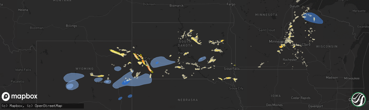
Hail Map in South Dakota on July 3, 2023
The weather event in South Dakota on July 3, 2023 includes Hail, Wind, and Tornado maps. 30 states and 943 cities were impacted and suffered possible damage. The total estimated number of properties impacted is 16,747.
Hail
Wind
Tornado
16,747
Estimated number of impacted properties by a 1.00" hail or larger3,904
Estimated number of impacted properties by a 1.75" hail or larger1,031
Estimated number of impacted properties by a 2.50" hail or largerStorm reports in South Dakota
South Dakota
| Date | Description |
|---|---|
| 07/03/20236:49 PM CDT | A local report indicates 2.75 inch wind near 7 E Rockerville |
| 07/03/20236:45 PM CDT | A local report indicates 1.50 inch wind near 4 ENE Rockerville |
| 07/03/20236:45 PM CDT | Reptile gardens |
| 07/03/20236:35 PM CDT | A local report indicates 1.50 inch wind near 4 S Dwtn Rapid City |
| 07/03/20236:34 PM CDT | A local report indicates 1.75 inch wind near Nemo |
| 07/03/20235:20 PM CDT | A local report indicates 1.00 inch wind near 3 W Dwtn Rapid City |
| 07/03/20235:20 PM CDT | Elongated hail stone |
| 07/03/20235:17 PM CDT | Mping report |
| 07/03/20235:17 PM CDT | Report from mping: ping pong ball |
| 07/03/20235:16 PM CDT | A local report indicates 1.75 inch wind near 4 NE Johnson Siding |
| 07/03/20235:15 PM CDT | Knbn |
| 07/03/20235:05 PM CDT | Picture received through social media. |
| 07/03/20234:50 PM CDT | A local report indicates 1.00 inch wind near Summerset |
| 07/03/20234:18 PM CDT | A local report indicates 1.75 inch wind near 1 NNW Piedmont |
| 07/03/20234:09 PM CDT | Delayed report via social media. |
| 07/03/20233:49 PM CDT | A local report indicates 1.00 inch wind near Utica |
| 07/03/20233:41 AM CDT | Mesonet station 201 gann valley |
| 07/03/20231:12 AM CDT | A local report indicates 59 MPH wind near 4 E Cactus Flat |
| 07/03/20231:02 AM CDT | A local report indicates 58 MPH wind near 4 E Cactus Flat |
| 07/03/202312:56 AM CDT | A local report indicates 61 MPH wind near 9 ENE Belvidere |
| 07/03/202312:47 AM CDT | A local report indicates 58 MPH wind near 4 E Cactus Flat |
| 07/03/202312:44 AM CDT | A local report indicates 61 MPH wind near 3 E Philip |
| 07/03/202312:41 AM CDT | A local report indicates 62 MPH wind near 5 NE Porcupine |
| 07/03/202312:37 AM CDT | A local report indicates 61 MPH wind near 4 E Cactus Flat |
| 07/03/202312:30 AM CDT | A local report indicates 67 MPH wind near 2 E Cottonwood |
| 07/03/202312:27 AM CDT | A local report indicates 72 MPH wind near 4 E Cactus Flat |
| 07/03/202312:22 AM CDT | A local report indicates 68 MPH wind near 4 E Cactus Flat |
| 07/03/202312:05 AM CDT | A local report indicates 61 MPH wind near 3 NNW Scenic |
| 07/02/202311:57 PM CDT | A local report indicates 63 MPH wind near 16 ESE Scenic |
| 07/02/202311:52 PM CDT | Report via social media. |
| 07/02/202311:39 PM CDT | Approximate time and location. |
| 07/02/202311:11 PM CDT | A local report indicates 62 MPH wind near 12 E Oelrichs |
| 07/02/202311:01 PM CDT | A local report indicates 65 MPH wind near 12 E Oelrichs |
| 07/02/202310:25 PM CDT | A local report indicates 58 MPH wind near 14 NNW Edgemont |
| 07/02/20238:45 PM CDT | A local report indicates 1.75 inch wind near 5 ENE Custer |
| 07/02/20238:05 PM CDT | A local report indicates 60 MPH wind near 7 SSW Folsom |
| 07/02/20237:33 PM CDT | A local report indicates 1.00 inch wind near Hermosa |
| 07/02/20237:16 PM CDT | Mostly pea size hail |
| 07/02/20237:04 PM CDT | Mping report |
All States Impacted by Hail Map on July 3, 2023
Cities Impacted by Hail Map on July 3, 2023
- Shipman, VA
- Wingina, VA
- Schuyler, VA
- Esmont, VA
- Howardsville, VA
- Lodge Grass, MT
- Wakita, OK
- Perry, OK
- Waukomis, OK
- Bison, OK
- Town Creek, AL
- Burlington, OK
- Red Rock, OK
- Stillwater, OK
- Fowler, IN
- Ames, OK
- Enid, OK
- Amorita, OK
- Boswell, IN
- Brookston, IN
- Wolcott, IN
- Chalmers, IN
- Earl Park, IN
- Forest City, NC
- Ellenboro, NC
- Mooresboro, NC
- Shelby, NC
- Grover, NC
- Gaffney, SC
- Blacksburg, SC
- Yankton, SD
- Lesterville, SD
- Utica, SD
- Stony Point, NY
- Fort Montgomery, NY
- Cortlandt Manor, NY
- Garrison, NY
- Bear Mountain, NY
- Tomkins Cove, NY
- Yorktown Heights, NY
- Shrub Oak, NY
- Mohegan Lake, NY
- Peekskill, NY
- Lake Peekskill, NY
- Crompond, NY
- Buchanan, NY
- Montrose, NY
- Verplanck, NY
- Putnam Valley, NY
- Jefferson Valley, NY
- Chesapeake, VA
- Portsmouth, VA
- Norfolk, VA
- Virginia Beach, VA
- Piedmont, SD
- Sturgis, SD
- Aylett, VA
- Walkerton, VA
- King William, VA
- Woodbine, GA
- Star Prairie, WI
- New Richmond, WI
- Deer Park, WI
- Hawarden, IA
- Alcester, SD
- Elk Point, SD
- Somers, NY
- Katonah, NY
- Mahopac, NY
- Amawalk, NY
- Granite Springs, NY
- Bruington, VA
- Saint Stephens Church, VA
- Black Hawk, SD
- Rapid City, SD
- Chatsworth, IA
- Akron, IA
- Aurelia, IA
- Alta, IA
- Lead, SD
- Grand View, WI
- Cable, WI
- Hayward, WI
- Mason, WI
- Drummond, WI
- Marengo, WI
- High Bridge, WI
- Clam Lake, WI
- Upson, WI
- Mellen, WI
- Iron Belt, WI
- Glidden, WI
- Butternut, WI
- Solon Springs, WI
- Linn Grove, IA
- Cherokee, IA
- Deadwood, SD
- Oxford, MD
- Cambridge, MD
- Trappe, MD
- Rush Valley, UT
- Dugway, UT
- Stockton, UT
- Tooele, UT
- Vernon, UT
- Lander, WY
- Arapahoe, WY
- Riverton, WY
- Fort Washakie, WY
- Kinnear, WY
- Pavillion, WY
- Hudson, WY
- Shoshoni, WY
- Jeffrey City, WY
- Lysite, WY
- Hermosa, SD
- Rembrandt, IA
- Storm Lake, IA
- North Beach, MD
- Saint Michaels, MD
- Royal Oak, MD
- Easton, MD
- Tilghman, MD
- Bozman, MD
- Sherwood, MD
- Neavitt, MD
- Wittman, MD
- Preston, MD
- Hurlock, MD
- East New Market, MD
- Secretary, MD
- Owings, MD
- Chesapeake Beach, MD
- Mercer, WI
- Park Falls, WI
- Winter, WI
- Hurley, WI
- Phillips, WI
- Fifield, WI
- Cedar Valley, UT
- Eureka, UT
- Orem, UT
- Santaquin, UT
- Spanish Fork, UT
- Goshen, UT
- Payson, UT
- Provo, UT
- Mapleton, UT
- Mona, UT
- Springville, UT
- Salem, UT
- Hill City, SD
- Port Wing, WI
- Houston, MS
- Scotland, SD
- Ashland, WI
- Iron River, WI
- Sheridan, AR
- Maple, WI
- Brule, WI
- Luck, WI
- Cushing, WI
- Frederic, WI
- Soda Springs, ID
- Yates Center, KS
- Cleveland, MS
- Moulton, AL
- Waskom, TX
- Eagle Butte, SD
- Williamston, NC
- Washington, NC
- Hammond, WI
- Baldwin, WI
- Homer, LA
- Gordon, WI
- Beresford, SD
- Shannon, MS
- Story, AR
- Emerson, AR
- Magnolia, AR
- Somerset, WI
- Ada, OK
- Stonewall, OK
- Cumberland, WI
- Martin, SD
- Courtland, VA
- Siren, WI
- Danbury, WI
- Webster, WI
- Nemo, SD
- Truman, MN
- Trimont, MN
- Welcome, MN
- Fairmont, MN
- Scott, AR
- England, AR
- Houlton, WI
- Hudson, WI
- Avon, SD
- Dante, SD
- Suffolk, VA
- Drumright, OK
- Jennings, OK
- Mannford, OK
- Mescalero, NM
- Centerville, SD
- Wakonda, SD
- Cove, AR
- Volin, SD
- Inman, SC
- Campobello, SC
- Pleasant Hill, NC
- Emporia, VA
- Margarettsville, NC
- Seaboard, NC
- Clarksville, TX
- Bagwell, TX
- Marshall, OK
- Union Grove, AL
- Arab, AL
- Hobbsville, NC
- Gatesville, NC
- Laceys Spring, AL
- Somerville, AL
- Valhermoso Springs, AL
- Nash, OK
- Jacksonville, FL
- Amery, WI
- Osceola, WI
- Dresser, WI
- Double Springs, AL
- Sulligent, AL
- Vernon, AL
- Roberts, WI
- Vivian, LA
- Jefferson, TX
- Minong, WI
- Rodessa, LA
- Collierville, TN
- Red Banks, MS
- Holly Springs, MS
- Byhalia, MS
- Pound Ridge, NY
- Bedford, NY
- Atwood, OK
- Longview, TX
- Harrellsville, NC
- Cofield, NC
- Hennepin, OK
- Ratliff City, OK
- Waldorf, MD
- Bryans Road, MD
- Alexandria, VA
- Lorton, VA
- Fort Belvoir, VA
- Fort Washington, MD
- Accokeek, MD
- Sunflower, MS
- Schlater, MS
- Tucker, AR
- Crescent, OK
- Bristow, OK
- Trinity, AL
- Smithville, OK
- Aberdeen, MS
- Okolona, MS
- Bernice, LA
- Mccurtain, OK
- Stigler, OK
- Collinsville, AL
- Wickes, AR
- Capron, VA
- Okemah, OK
- Greenville, NC
- Paden, OK
- Boley, OK
- Addison, AL
- Ranburne, AL
- Heflin, AL
- Bowdon, GA
- Hot Springs National Park, AR
- Fairmont, OK
- Douglas, OK
- McCaskill, AR
- Roff, OK
- Tatum, NM
- Eudora, AR
- Dermott, AR
- Scotland Neck, NC
- Enfield, NC
- Pontotoc, MS
- Gunnison, MS
- Courtland, MS
- Little Rock, AR
- Castle, OK
- Superior, WI
- Marietta, MS
- Fulton, MS
- Mantachie, MS
- Two Harbors, MN
- Stuart, OK
- Mcalester, OK
- Fulton, AR
- Morganton, NC
- Guntersville, AL
- Ireton, IA
- Farmerville, LA
- Central Valley, NY
- Bedford Hills, NY
- Harriman, NY
- Monroe, NY
- Southfields, NY
- Whiteville, NC
- Kingfisher, OK
- Mulhall, OK
- Crossville, AL
- Boaz, AL
- New Hope, AL
- Huntsville, AL
- Owens Cross Roads, AL
- Red Bay, AL
- Leesburg, AL
- Knotts Island, NC
- Umpire, AR
- Glen, MS
- Booneville, MS
- Burnsville, MS
- Rienzi, MS
- Mangham, LA
- Graham, OK
- Healdton, OK
- Clinton, NC
- Tabor City, NC
- Maidens, VA
- Rockville, VA
- Oilville, VA
- Itta Bena, MS
- Greenwood, LA
- Crozier, VA
- Goochland, VA
- Manakin Sabot, VA
- Powhatan, VA
- Mer Rouge, LA
- Atlanta, TX
- Baileyton, AL
- Eva, AL
- Sims, AR
- Mount Ida, AR
- Gregory, SD
- Dallas, SD
- Halifax, NC
- Blossom, TX
- Detroit, TX
- Roland, AR
- Bruce, MS
- Houlka, MS
- Randolph, MS
- Arthur City, TX
- Irene, SD
- Springville, PA
- Meshoppen, PA
- Spearsville, LA
- Junction City, AR
- Lillie, LA
- Ely, MN
- Waverly, GA
- Mounds, OK
- Beggs, OK
- Danville, AR
- Belleville, AR
- Shreveport, LA
- Altus, OK
- Hillsboro, AL
- Courtland, AL
- Darien, GA
- Townsend, GA
- Walters, OK
- Haynesville, LA
- Avinger, TX
- Silver Bay, MN
- Houston, AR
- Perryville, AR
- Ashland, VA
- Cushing, OK
- Yale, OK
- Moorhead, MS
- Henryetta, OK
- Okmulgee, OK
- Amboy, MN
- Chocowinity, NC
- Brunswick, GA
- Belcher, LA
- Mooringsport, LA
- Guthrie, OK
- Edmond, OK
- Blackshear, GA
- Patterson, GA
- Holdenville, OK
- Calvin, OK
- Diana, TX
- Centuria, WI
- Balsam Lake, WI
- Saint Croix Falls, WI
- Laceyville, PA
- Montrose, PA
- El Reno, OK
- Hinton, OK
- Comstock, WI
- Lovington, NM
- Brimson, MN
- Nettleton, MS
- Amory, MS
- Depew, OK
- South Boston, VA
- Halifax, VA
- Victor, ID
- Driggs, ID
- Lava Hot Springs, ID
- Bigelow, AR
- Keo, AR
- Seminole, OK
- Prague, OK
- Olive Branch, MS
- Omega, OK
- Rutherfordton, NC
- Belmont, MS
- Golden, MS
- New Site, MS
- Dennis, MS
- Mission Hill, SD
- Drewryville, VA
- Boykins, VA
- Croton On Hudson, NY
- Sherburn, MN
- Dunnell, MN
- Flomot, TX
- Grapevine, AR
- Rohwer, AR
- Hot Springs Village, AR
- Jessieville, AR
- Mound Bayou, MS
- Rayville, LA
- Rossville, TN
- Oak Ridge, LA
- Hawkinsville, GA
- Tishomingo, MS
- Redfield, AR
- Washington, AR
- Spruce Pine, AL
- Russellville, AL
- Greenwood, MS
- Corinth, MS
- Marshall, TX
- Watson, OK
- South Mills, NC
- Macon, GA
- Orlando, OK
- Mena, AR
- Hallsville, TX
- Sterling, KS
- Oxford, MS
- Albertville, AL
- Hennessey, OK
- Webbers Falls, OK
- Porum, OK
- Malvern, AR
- Drew, MS
- Ruleville, MS
- Merigold, MS
- Duluth, MN
- Culloden, GA
- Yatesville, GA
- Paris, TX
- Spindale, NC
- Kings Mountain, NC
- Mill Spring, NC
- Gilmer, TX
- Ore City, TX
- Hartselle, AL
- Clarkton, NC
- Hatfield, AR
- South Salem, NY
- Gretna, VA
- Lake Waccamaw, NC
- Council, NC
- Mccammon, ID
- Canton, MS
- Folkston, GA
- Anadarko, OK
- Fort Cobb, OK
- Pawnee, OK
- Arcadia, OK
- Pomeroy, IA
- Manson, IA
- Rockwell City, IA
- Jolley, IA
- Salt Lake City, UT
- West Valley City, UT
- Bingham Canyon, UT
- Bountiful, UT
- Magna, UT
- North Salt Lake, UT
- Grantsville, UT
- West Jordan, UT
- Vineyard, UT
- Wallsburg, UT
- American Fork, UT
- Pleasant Grove, UT
- Lindon, UT
- Midway, UT
- Heber City, UT
- Oakley, UT
- Kamas, UT
- Mountain Home, UT
- Fruitland, UT
- Hanna, UT
- Tabiona, UT
- Roosevelt, UT
- Talmage, UT
- Park City, UT
- Coalville, UT
- Peoa, UT
- Saratoga Springs, UT
- Sandy, UT
- Alpine, UT
- Federalsburg, MD
- Wheatland, WY
- Hastings, MN
- Fairburn, SD
- Pine Ridge, SD
- Custer, SD
- Keystone, SD
- Evansville, WY
- Casper, WY
- Mills, WY
- Natrona, WY
- Douglas, WY
- Glenrock, WY
- Glendo, WY
- Shawnee, WY
- Lakeville, MN
- Rosemount, MN
- Farmington, MN
- Saint Paul, MN
- Dundas, MN
- Northfield, MN
- Lingle, WY
- Torrington, WY
- Veteran, WY
- Morrill, NE
- Lance Creek, WY
- Lost Springs, WY
- Manville, WY
- Lusk, WY
- Harrison, NE
- Van Tassell, WY
- Gillette, WY
- Rozet, WY
- Moorcroft, WY
- Imperial, TX
- Upton, WY
- Edgemont, SD
- Newcastle, WY
- Smithwick, SD
- Oelrichs, SD
- Whitney, NE
- Oral, SD
- Crawford, NE
- Chadron, NE
- Tolstoy, SD
- Onaka, SD
- Seneca, SD
- Florence, SD
- Henry, SD
- Oglala, SD
- Rushville, NE
- Hay Springs, NE
- Garretson, SD
- Little Elm, TX
- Bruce, WI
- Menomonie, WI
- Stillwater, MN
- Glen Flora, WI
- Tony, WI
- Gilman, WI
- Livingston, MT
- Washburn, WI
- Hooper, UT
- Ladysmith, WI
- Caddo Gap, AR
- Glenwood, AR
- Sheldon, WI
- Hobbs, NM
- Sundance, WY
- Devils Tower, WY
- Belle Fourche, SD
- Evanston, WY
- Eau Galle, WI
- Elmwood, WI
- Gettysburg, SD
- Springer, OK
- Matador, TX
- Mckinney, TX
- Afton, MN
- River Falls, WI
- White Hall, AR
- Wilson, OK
- Orient, SD
- Seminole, TX
- Cornell, WI
- Honey Grove, TX
- Kennan, WI
- Hawkins, WI
- Commerce, TX
- Campbell, TX
- Wallace, SD
- Fort Stockton, TX
- Garysburg, NC
- Conrath, WI
- Holcombe, WI
- Murdo, SD
- Turtle Lake, WI
- North Garden, VA
- Faber, VA
- Lovingston, VA
- Piney River, VA
- Arrington, VA
- Roseland, VA
- Draper, SD
- Seaford, DE
- Bridgeville, DE
- Collinsville, TX
- Howe, TX
- Marine On Saint Croix, MN
- Scandia, MN
- Cottage Grove, MN
- Tyndall, SD
- Tabor, SD
- Clare, IA
- Frisco, TX
- Prattsville, AR
- Claflin, KS
- Leola, AR
- Carthage, AR
- Lancaster, VA
- Weems, VA
- Monahans, TX
- Saint Paul Park, MN
- Spring Valley, WI
- Woodville, WI
- Center City, MN
- Bald Knob, AR
- Elk Mound, WI
- Mondovi, WI
- Sadler, TX
- Whitesboro, TX
- Sherman, TX
- Couderay, WI
- Lindstrom, MN
- Holstein, IA
- Quimby, IA
- Lublin, WI
- Thorp, WI
- Brookston, TX
- Sarah, MS
- Crenshaw, MS
- Sardis, MS
- Shafer, MN
- Taylors Falls, MN
- Alden, KS
- Kingsley, IA
- Correctionville, IA
- Pierson, IA
- Washta, IA
- Galva, IA
- Batesville, MS
- Peterson, IA
- Plains, TX
- Withee, WI
- Caputa, SD
- Maiden Rock, WI
- Ellsworth, WI
- Arkansaw, WI
- Plum City, WI
- Whitewright, TX
- Bonham, TX
- Trenton, TX
- Stanley, WI
- Boyd, WI
- Celina, TX
- Albert City, IA
- Palmer, IA
- Watson, AR
- Highland Mills, NY
- Cornwall, NY
- Towson, MD
- Branchville, VA
- Columbus, MS
- Como, MS
- Bayport, MN
- Scottsburg, VA
- New Canaan, CT
- Stamford, CT
- Milltown, WI
- Lakeland, MN
- Clear Lake, WI
- Wilson, WI
- Broken Bow, OK
- Telephone, TX
- Gainesville, TX
- Cannon Falls, MN
- Randolph, MN
- Lutherville Timonium, MD
- Loris, SC
- Tunica, MS
- Prosper, TX
- Sledge, MS
- Marks, MS
- Monument, NM
- Grayson, GA
- Lawrenceville, GA
- Loganville, GA
- Valley Cottage, NY
- Congers, NY
- Lake City, MN
- Donaldson, AR
- Friendship, AR
- Arkadelphia, AR
- Sheffield, TX
- Klondike, TX
- Wright, WY
- Ringling, OK
- Powderly, TX
- Roxton, TX
- Petty, TX
- Sumner, TX
- Macon, MS
- Brooksville, MS
- Nerstrand, MN
- Faribault, MN
- Elmore City, OK
- Tillar, AR
- Lonsdale, MN
- Webster, MN
- Gilmore City, IA
- Cumby, TX
- Ladonia, TX
- Greenville, TX
- Pecan Gap, TX
- Waco, GA
- Milburn, OK
- Senatobia, MS
- Chippewa Falls, WI
- Eau Claire, WI
- Westover, MD
- Gunter, TX
- Pilot Point, TX
- Lake Dallas, TX
- McCall Creek, MS
- Union Church, MS
- Brookhaven, MS
- Faulkton, SD
- Orange City, IA
- Maurice, IA
- Hot Springs, SD
- Topping, VA
- White Stone, VA
- Goldens Bridge, NY
- Mount Kisco, NY
- King And Queen Court House, VA
- Muscadine, AL
- Valley View, TX
- Inver Grove Heights, MN
- Many, LA
- Palatka, FL
- Manquin, VA
- Long Valley, SD
- Wanblee, SD
- Valliant, OK
- Dundee, MS
- Vermillion, MN
- Spout Spring, VA
- Concord, VA
- Denver City, TX
- Wilsonville, AL
- Columbiana, AL
- Olustee, OK
- Elmer, OK
- Rich Square, NC
- Hanover, VA
- Center Cross, VA
- West Point, MS
- Minco, OK
- Fitzhugh, OK
- Rosston, TX
- Era, TX
- Forestburg, TX
- Beldenville, WI
- Aubrey, TX
- Savoy, TX
- Wilton, CT
- Ridgefield, CT
- Marion Station, MD
- Princess Anne, MD
- Waltham, MN
- Hugo, OK
- Prescott, WI
- Ector, TX
- Schaller, IA
- Wall, SD
- Scenic, SD
- Interior, SD
- Quinn, SD
- Owanka, SD
- New Underwood, SD
- Kadoka, SD
- Kyle, SD
- Wasta, SD
- Philip, SD
- Vermillion, SD
- Burbank, SD
- Belvidere, SD
- Okaton, SD
- White River, SD
- Midland, SD
- Selby, SD
- Bowdle, SD
- Java, SD
- Hosmer, SD
- Bradley, SD
- Wood, SD
- Hoven, SD
- Redfield, SD
- Huron, SD
- Winner, SD
- Pierre, SD
- Fort Pierre, SD
- Raymond, SD
- Houston, MN
- Randolph, TX
- Turton, SD
- Charlottesville, VA
- Millville, MN
- Alma, WI
- Nelson, WI
- Frankfort, SD
- Doland, SD
- Rhodesdale, MD
- Blunt, SD
- Mechanicsville, VA
- Garden City, SD
- Greenwood, DE
- Kellogg, MN
- Wabasha, MN
- White Plains, MD
- Mission, SD
- Presho, SD
- Lake Preston, SD
- Bivins, TX
- Independence, WI
- Woonsocket, SD
- Dubach, LA
- Wykoff, MN
- Preston, MN
- Spring Valley, MN
- Upper Marlboro, MD
- Brandywine, MD
- Rehoboth Beach, DE
- Lewes, DE
- Bryant, SD
- Yale, SD
- Willow Lake, SD
- Carpenter, SD
- Iroquois, SD
- De Smet, SD
- Le Roy, MN
- Ashton, SD
- Millsboro, DE
- Harbeson, DE
- Mount Holly, AR
- El Dorado, AR
- Altura, MN
- Erwin, SD
- Rollingstone, MN
- Colome, SD
- Moville, IA
- Durand, WI
- Parkville, MD
- Baltimore, MD
- Oil City, LA
- Trempealeau, WI
- Galesville, WI
- Vivian, SD
- Dell Rapids, SD
- Fountain City, WI
- Arcadia, WI
- Saluda, VA
- Manly, IA
- Mason City, IA
- Stoddard, WI
- Clark, SD
- Witten, SD
- La Crescent, MN
- Hokah, MN
- Brownsville, MN
- Tioga, TX
- Plainview, MN
- Crisfield, MD
- Dakota, MN
- Winona, MN
- Pukwana, SD
- Fort Thompson, SD
- Wessington Springs, SD
- Gann Valley, SD
- Kimball, SD
- Reliance, SD
- Chamberlain, SD
- Oacoma, SD
- Artesian, SD
- Platte, SD
- Letcher, SD
- Lawler, IA
- White Lake, SD
- Mount Vernon, SD
- Stickney, SD
- Kennebec, SD
- Belmont, LA
- Carmel, NY
- Mitchell, SD
- Plankinton, SD
- Valentine, NE
- Burke, SD
- New Hampton, IA
- Fredericksburg, IA
- Trail City, SD
- Roscoe, SD
- Waverly, IA
- Shell Rock, IA
- Ethan, SD
- Fort Dodge, IA
- Janesville, IA
- Sacred Heart, MN
- The Colony, TX


