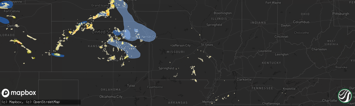
Hail Map in Missouri on July 4, 2023
The weather event in Missouri on July 4, 2023 includes Wind and Hail maps. 24 states and 951 cities were impacted and suffered possible damage. The total estimated number of properties impacted is 0.
Wind
Hail
0
Estimated number of impacted properties by a 1.00" hail or larger0
Estimated number of impacted properties by a 1.75" hail or larger0
Estimated number of impacted properties by a 2.50" hail or largerStorm reports in Missouri
Missouri
| Date | Description |
|---|---|
| 07/04/20231:29 AM CDT | Trees blown down blocking one lane of highway d near lawson. |
| 07/04/20231:25 AM CDT | Report from mping: 3-inch tree limbs broken. |
| 07/04/20231:25 AM CDT | Report from mping: 3-in |
| 07/04/20231:12 AM CDT | Large tree branch across the road. |
| 07/04/20231:12 AM CDT | Large tree branch across the road. ( |
| 07/04/20231:10 AM CDT | A local report indicates 60 MPH wind near Independence |
| 07/04/202312:55 AM CDT | Delayed report of tree damage at ward parkway and 68th street. |
| 07/04/202312:55 AM CDT | Delayed report of tree damage at 49th street in west plaza. |
| 07/04/202312:46 AM CDT | Mkc asos measurement. |
| 07/04/202312:46 AM CDT | 11 inch diameter limb broken. |
| 07/04/202312:40 AM CDT | Reported via social media. |
| 07/04/202312:27 AM CDT | A local report indicates 63 MPH wind near 1 NW Kansas City Intl A |
| 07/04/202312:26 AM CDT | A local report indicates 61 MPH wind near 1 NW Kansas City Intl A |
| 07/04/202312:13 AM CDT | A local report indicates 63 MPH wind near 6 ENE Iatan |
| 07/04/202312:13 AM CDT | From personal weather station. Reported via social media. Time estimated by radar. |
| 07/04/202312:05 AM CDT | Report from mping: 1-inch tree limbs broken; timing estimated via radar. |
| 07/03/202311:55 PM CDT | A local report indicates 66 MPH wind near 1 NNE Saint Joseph Airp |
| 07/03/202311:47 PM CDT | A local report indicates 60 MPH wind near Atchison |
All States Impacted by Hail Map on July 4, 2023
Cities Impacted by Hail Map on July 4, 2023
- Scenic, SD
- Kyle, SD
- Interior, SD
- Pine Ridge, SD
- Caputa, SD
- Wall, SD
- New Underwood, SD
- Kadoka, SD
- Wasta, SD
- Owanka, SD
- Wanblee, SD
- Somerville, AL
- Union Grove, AL
- Arab, AL
- Hudson, WI
- River Falls, WI
- Roberts, WI
- Hastings, MN
- Cottage Grove, MN
- Saint Paul, MN
- Stillwater, MN
- Renville, MN
- Sacred Heart, MN
- Lake Andes, SD
- Wagner, SD
- Hurley, SD
- Bird Island, MN
- Honey Grove, TX
- Freeman, SD
- Viborg, SD
- Saint Paul Park, MN
- Inver Grove Heights, MN
- Mount Vernon, SD
- Mitchell, SD
- Buffalo Lake, MN
- Hector, MN
- Olivia, MN
- Danube, MN
- Utica, SD
- Lesterville, SD
- Avon, SD
- Irene, SD
- Tyndall, SD
- Sumner, TX
- Telephone, TX
- Scotland, SD
- Menno, SD
- Yankton, SD
- Tabor, SD
- Festus, MO
- Beldenville, WI
- Ellsworth, WI
- Afton, MN
- Colorado Springs, CO
- Peyton, CO
- Wheatland, WY
- Guernsey, WY
- Fort Laramie, WY
- Lingle, WY
- Yoder, WY
- Sanger, TX
- Calhan, CO
- Yoder, CO
- Humphrey, NE
- Lindsay, NE
- Genoa, NE
- Saint Edward, NE
- Platte Center, NE
- Monroe, NE
- Norfolk, NE
- Meadow Grove, NE
- Battle Creek, NE
- Pierce, NE
- Grinnell, KS
- Oakley, KS
- Columbus, NE
- Creston, NE
- Kensington, KS
- Agra, KS
- Cedar, KS
- Gaylord, KS
- Kirwin, KS
- Veteran, WY
- Torrington, WY
- Lyman, NE
- Gering, NE
- Morrill, NE
- Hoxie, KS
- Leoti, KS
- Manitou Springs, CO
- Cascade, CO
- Ordway, CO
- Manzanola, CO
- Sugar City, CO
- Rocky Ford, CO
- Olney Springs, CO
- Crowley, CO
- Selden, KS
- Morland, KS
- Campbell, NE
- Riverton, NE
- Inavale, NE
- Bladen, NE
- Sutton, NE
- Grafton, NE
- Henderson, NE
- Silver Creek, NE
- Duncan, NE
- Shelby, NE
- Osceola, NE
- Ponca, NE
- Dixon, NE
- Waterbury, NE
- Allen, NE
- Jackson, NE
- Sioux City, IA
- North Sioux City, SD
- Dakota City, NE
- South Sioux City, NE
- Lawton, IA
- Jefferson, SD
- Salix, IA
- Sergeant Bluff, IA
- Homer, NE
- Hubbard, NE
- Bronson, IA
- Emerson, NE
- Madison, NE
- Cherry Hill, NJ
- Ridgeville, SC
- Adams Run, SC
- Cottageville, SC
- Plattsburgh, NY
- West Chazy, NY
- Tunica, MS
- Fremont, MO
- Van Buren, MO
- Taylor, AR
- Hamilton, KS
- Mansfield, MO
- Irondale, MO
- Bismarck, MO
- Caledonia, MO
- Ironton, MO
- Brundidge, AL
- Banks, AL
- Sikes, LA
- Newcastle, NE
- Chester, IL
- Gillette, NJ
- Berkeley Heights, NJ
- Warren, NJ
- Watchung, NJ
- Alton, IA
- Hospers, IA
- Ellington, MO
- Leigh, NE
- Bunker Hill, IL
- Shipman, IL
- Osseo, WI
- Hixton, WI
- East Hardwick, VT
- Troy, AL
- Winona, KS
- Wrightstown, NJ
- Trenton, NJ
- Allentown, NJ
- Chesterfield, NJ
- Bellwood, NE
- La Junta, CO
- Saint Mary, MO
- Hartington, NE
- Jacksonville, FL
- Pemberton, NJ
- Benedict, NE
- Stromsburg, NE
- De Soto, MO
- Durant, MS
- Peru, NY
- Morgan, VT
- Usaf Academy, CO
- Alton, MO
- Model, CO
- Lamar, CO
- Water Valley, MS
- Batesville, MS
- Oxford, MS
- Columbus, NJ
- Jobstown, NJ
- Cream Ridge, NJ
- Stewart, MS
- Eupora, MS
- Wallace, KS
- Hinton, IA
- Doniphan, MO
- Fleming, GA
- Richmond Hill, GA
- Rouses Point, NY
- Yorktown, AR
- Gould, AR
- Star City, AR
- Sainte Genevieve, MO
- Perryville, MO
- Philipp, MS
- Doe Run, MO
- Park Hills, MO
- Elizabethtown, NY
- Warren, TX
- Tilden, NE
- Conway, MO
- Long Lane, MO
- Boone, CO
- Le Mars, IA
- Merrill, IA
- Mellwood, AR
- Taylor, MS
- Courtland, MS
- Stumpy Point, NC
- Newman Grove, NE
- Schuyler, NE
- Joint Base Mdl, NJ
- Robbinsville, NJ
- Forkland, AL
- West Helena, AR
- Greenback, TN
- Orlando, FL
- Hardeeville, SC
- Eminence, MO
- Salem, MO
- Sicily Island, LA
- Rising Star, TX
- Cisco, TX
- Carbon, TX
- Myrtle, MO
- Kountze, TX
- Charleston, MS
- Clarkson, NE
- Gatewood, MO
- Saint Johns, FL
- Orange City, IA
- Belvidere Center, VT
- Thomasville, AL
- Winona, MO
- Marion, IL
- Pittsburg, IL
- Summerville, SC
- Memphis, TN
- Germantown, TN
- Pueblo, CO
- Fouke, AR
- Winter, WI
- Clarksdale, MS
- Alligator, MS
- Alburgh, VT
- Champlain, NY
- Bolton, NC
- Crown Point, NY
- Ticonderoga, NY
- Tabor City, NC
- East Dublin, GA
- Wrightsville, GA
- Saint Augustine, FL
- Couch, MO
- Saint Cloud, FL
- Rentz, GA
- Morrisonville, NY
- Altona, NY
- Lake Waccamaw, NC
- Divide, CO
- Wakefield, NE
- Warm Springs, AR
- Boligee, AL
- Bound Brook, NJ
- Dunellen, NJ
- Martinsville, NJ
- Middlesex, NJ
- Mount Laurel, NJ
- Marlton, NJ
- Kingsley, IA
- Gilman, WI
- Mount Holly, NJ
- Bordentown, NJ
- Hainesport, NJ
- Vincentown, NJ
- Burlington, NJ
- Lumberton, NJ
- Medford, NJ
- Cookstown, NJ
- Hightstown, NJ
- New Egypt, NJ
- Glendora, MS
- Philadelphia, TN
- Loudon, TN
- Charleston, SC
- Goose Creek, SC
- Geneva, NE
- Glade, KS
- New London, MO
- Winter Park, FL
- Lyons, CO
- Fort Lupton, CO
- Longmont, CO
- Platteville, CO
- Mead, CO
- Johnstown, CO
- Milliken, CO
- Eureka, KS
- Hill City, KS
- Penokee, KS
- Lenora, KS
- Norton, KS
- Stockton, KS
- Phillipsburg, KS
- Tribune, KS
- Syracuse, KS
- Ayr, NE
- Blue Hill, NE
- Roseland, NE
- Fairfield, NE
- Glenvil, NE
- Lawrence, NE
- Clay Center, NE
- Deweese, NE
- Edgar, NE
- Nelson, NE
- Fairmont, NE
- McCool Junction, NE
- Shickley, NE
- Bruning, NE
- Strang, NE
- Carleton, NE
- Ong, NE
- Dwight, NE
- Valparaiso, NE
- Malmo, NE
- Bruno, NE
- Abie, NE
- Colon, NE
- Ulysses, NE
- Rising City, NE
- Linwood, NE
- Wahoo, NE
- Prague, NE
- Brainard, NE
- Weston, NE
- David City, NE
- Ceresco, NE
- Ithaca, NE
- Ashland, NE
- Waverly, NE
- Raymond, NE
- Memphis, NE
- Greenwood, NE
- Seward, NE
- Davey, NE
- Alvo, NE
- Elmwood, NE
- Eagle, NE
- Lincoln, NE
- Garland, NE
- Avoca, NE
- Bee, NE
- Weeping Water, NE
- Murdock, NE
- Palmyra, NE
- Pleasant Dale, NE
- Unadilla, NE
- Walton, NE
- Staplehurst, NE
- Bennet, NE
- Malcolm, NE
- Denton, NE
- Martell, NE
- Crete, NE
- Hickman, NE
- Adams, NE
- Roca, NE
- Milford, NE
- Surprise, NE
- Gresham, NE
- Waco, NE
- Utica, NE
- Goehner, NE
- Beaver Crossing, NE
- Kendall, KS
- Lakin, KS
- Coolidge, KS
- Oak, NE
- Davenport, NE
- Long Island, KS
- Almena, KS
- Prairie View, KS
- Deerfield, KS
- Holcomb, KS
- Granby, CO
- Parshall, CO
- Kremmling, CO
- Grand Lake, CO
- Hot Sulphur Springs, CO
- Rollinsville, CO
- Nederland, CO
- Tabernash, CO
- Winter Park, CO
- Ward, CO
- Fraser, CO
- Sprague, NE
- Hallam, NE
- Cook, NE
- Douglas, NE
- Firth, NE
- Syracuse, NE
- Burr, NE
- Panama, NE
- Sterling, NE
- Johnson, NE
- Tecumseh, NE
- Filley, NE
- Beatrice, NE
- Lewiston, NE
- Pickrell, NE
- Liberty, NE
- Clatonia, NE
- Cortland, NE
- Steinauer, NE
- Virginia, NE
- Elk Creek, NE
- Crab Orchard, NE
- Burchard, NE
- Jamestown, CO
- Central City, CO
- Boulder, CO
- Golden, CO
- Black Hawk, CO
- Eldorado Springs, CO
- Humboldt, NE
- Auburn, NE
- Table Rock, NE
- Pawnee City, NE
- Harvard, NE
- Saronville, NE
- Wilsey, KS
- Council Grove, KS
- Du Bois, NE
- Bern, KS
- Dawson, NE
- Salem, NE
- Baileyville, KS
- Seneca, KS
- Oneida, KS
- Sabetha, KS
- Buford, WY
- Tie Siding, WY
- Laramie, WY
- Cheyenne, WY
- Livermore, CO
- Red Feather Lakes, CO
- Granite Canon, WY
- Wellington, CO
- Laporte, CO
- Fort Collins, CO
- Verdon, NE
- Hiawatha, KS
- Morrill, KS
- Fairview, KS
- Powhattan, KS
- Horton, KS
- Soldier, KS
- Corning, KS
- Centralia, KS
- Vermillion, KS
- Frankfort, KS
- Wetmore, KS
- Circleville, KS
- Onaga, KS
- Netawaka, KS
- Axtell, KS
- Havensville, KS
- Goff, KS
- Westmoreland, KS
- Whiting, KS
- Oketo, KS
- Home, KS
- Summerfield, KS
- Wymore, NE
- Beattie, KS
- Blue Springs, NE
- Clay Center, KS
- Morganville, KS
- Green, KS
- Randolph, KS
- Leonardville, KS
- Riley, KS
- Manhattan, KS
- Milford, KS
- Wakefield, KS
- Junction City, KS
- Gypsum, KS
- Assaria, KS
- New Cambria, KS
- Lindsborg, KS
- Hope, KS
- Salina, KS
- Solomon, KS
- Abilene, KS
- Herington, KS
- Burdick, KS
- Woodbine, KS
- Enterprise, KS
- Chapman, KS
- Lost Springs, KS
- Ramona, KS
- White City, KS
- Tampa, KS
- Lincolnville, KS
- Durham, KS
- Everest, KS
- Robinson, KS
- Muscotah, KS
- Holton, KS
- Lancaster, KS
- Atchison, KS
- Effingham, KS
- Denton, KS
- Delia, KS
- Emmett, KS
- Hoyt, KS
- Saint Marys, KS
- Mayetta, KS
- Meriden, KS
- Valley Falls, KS
- Silver Lake, KS
- Nortonville, KS
- Topeka, KS
- Cummings, KS
- Denison, KS
- Rossville, KS
- Ozawkie, KS
- Maple Hill, KS
- Alma, KS
- Belvue, KS
- Wamego, KS
- Paxico, KS
- McFarland, KS
- Olsburg, KS
- Saint George, KS
- Auburn, KS
- Eskridge, KS
- Harveyville, KS
- Wakarusa, KS
- Carbondale, KS
- Burlingame, KS
- Tecumseh, KS
- Berryton, KS
- Grantville, KS
- Oskaloosa, KS
- Winchester, KS
- McLouth, KS
- Perry, KS
- Lecompton, KS
- Allen, KS
- Alta Vista, KS
- Dwight, KS
- Admire, KS
- Reading, KS
- Emporia, KS
- Americus, KS
- Strong City, KS
- Marion, KS
- Elmdale, KS
- Cottonwood Falls, KS
- Fairlee, VT
- Windsor, VT
- Franklin, NE
- Winnebago, NE
- Walthill, NE
- Macy, NE
- Upland, NE
- Sloan, IA
- Whiting, IA
- Tekamah, NE
- Craig, NE
- Stowe, VT
- Little Sioux, IA
- Blencoe, IA
- Onawa, IA
- Florissant, CO
- Minneapolis, KS
- Mason, TN
- Walden, CO
- Berthoud, CO
- Fort Edward, NY
- Argyle, NY
- Marienthal, KS
- Byhalia, MS
- Durand, WI
- Kinderhook, NY
- Stuyvesant, NY
- Selkirk, NY
- Castleton On Hudson, NY
- Valatie, NY
- Schodack Landing, NY
- Maynard, AR
- Pocahontas, AR
- Ravenden Springs, AR
- Rolla, MO
- Saint James, MO
- Bennington, KS
- Republican City, NE
- Schenectady, NY
- Ballston Lake, NY
- Amsterdam, NY
- Galway, NY
- Hernando, MS
- Clinton, NC
- Turkey, NC
- Monument, KS
- Mapleton, IA
- Glenmont, NY
- Ghent, NY
- Hudson, NY
- Ravena, NY
- Coeymans, NY
- Delmar, NY
- South Bethlehem, NY
- York, NE
- Punta Gorda, FL
- Maiden Rock, WI
- Bay City, WI
- Olive Branch, MS
- Colby, KS
- Athol, KS
- Morton, MS
- Pelahatchie, MS
- Brandon, MS
- Mendenhall, MS
- Greenwich, NY
- Schuylerville, NY
- Kingston, GA
- Taylorsville, GA
- Saint Pauls, NC
- Ellsworth, KS
- Clayton, LA
- Castana, IA
- Smithland, IA
- Rodney, IA
- Wasola, MO
- Exeter, NE
- Nelson, WI
- Mondovi, WI
- Stockholm, WI
- Plum City, WI
- Arkansaw, WI
- Holstein, NE
- Denton, TX
- Autryville, NC
- Stedman, NC
- Marion, SC
- Aynor, SC
- Nichols, SC
- Galivants Ferry, SC
- Mullins, SC
- Moville, IA
- Hornick, IA
- Rifle, CO
- Tipton, KS
- Longford, KS
- Duanesburg, NY
- Bloomington, NE
- Naponee, NE
- Hagaman, NY
- Portis, KS
- Pender, NE
- Bushton, KS
- Inland, NE
- Fredericktown, MO
- Potosi, MO
- Belgrade, MO
- Farmington, MO
- Parsons, TN
- Ireton, IA
- Rogers, NE
- Clarks, NE
- Morse Bluff, NE
- Walhalla, SC
- Thornfield, MO
- Squires, MO
- Drury, MO
- Norwood, MO
- Ava, MO
- Miltonvale, KS
- Osage City, KS
- Somerville, TN
- Oakland, TN
- Alton, KS
- Lake Placid, FL
- Bellvue, CO
- Rosalie, NE
- Bancroft, NE
- Pinson, AL
- Logan, KS
- Lyons, NE
- Barnes, KS
- Greenleaf, KS
- Luray, TN
- Huron, TN
- Henderson, TN
- Jacks Creek, TN
- Evergreen, CO
- Clifton, KS
- Palmer, KS
- Holly, CO
- Bogue, KS
- Cambridge, VT
- Smith Center, KS
- Woodbine, IA
- Logan, IA
- Elsberry, MO
- Osborne, KS
- Ballston Spa, NY
- Myakka City, FL
- Clayton, KS
- Jennings, KS
- Henning, TN
- Hillsboro, MO
- Warsaw, NC
- Decatur, NE
- Lonedell, MO
- Saint Clair, MO
- Batchtown, IL
- Hamburg, IL
- Mountain Grove, MO
- Bourbon, MO
- Fieldon, IL
- Hardin, IL
- Belvidere, NE
- Medon, TN
- Pinson, TN
- Fairbury, NE
- Dillon, SC
- Anthon, IA
- Toone, TN
- Hyde Park, VT
- Johnson, VT
- Waynesboro, TN
- Collinwood, TN
- Lake Cormorant, MS
- South Fulton, TN
- Remlap, AL
- Ladson, SC
- North Charleston, SC
- East Greenbush, NY
- Rensselaer, NY
- Concordia, KS
- Pine, CO
- Hendley, NE
- Fork, SC
- Stanton, TN
- Geneseo, KS
- Bolivar, TN
- Hildreth, NE
- Woodston, KS
- Slingerlands, NY
- Delphos, KS
- Cordova, NE
- Friend, NE
- Agency, MO
- Weston, MO
- Saint Joseph, MO
- Faucett, MO
- Bendena, KS
- Leavenworth, KS
- Highland, KS
- Wathena, KS
- Dearborn, MO
- Rushville, MO
- Troy, KS
- De Kalb, MO
- Easton, KS
- Camden Point, MO
- Liberty, MO
- Platte City, MO
- Kearney, MO
- Holt, MO
- Kansas City, MO
- Lathrop, MO
- Trimble, MO
- Farley, MO
- Fort Leavenworth, KS
- Edgerton, MO
- Gower, MO
- Lawson, MO
- Excelsior Springs, MO
- Plattsburg, MO
- Smithville, MO
- Lansing, KS
- Bonner Springs, KS
- Overland Park, KS
- Linwood, KS
- Prairie Village, KS
- Tonganoxie, KS
- Lenexa, KS
- Waldron, MO
- Kansas City, KS
- Riverside, MO
- De Soto, KS
- Basehor, KS
- Lawrence, KS
- Mission, KS
- Gardner, KS
- Shawnee, KS
- Olathe, KS
- Eudora, KS
- New Century, KS
- Lebo, KS
- Melvern, KS
- Le Roy, KS
- Garnett, KS
- Matfield Green, KS
- Olpe, KS
- Westphalia, KS
- Neosho Rapids, KS
- Welda, KS
- Gridley, KS
- Hartford, KS
- Madison, KS
- Waverly, KS
- Burlington, KS
- Morrisville, VT
- Cornish, NH
- Claremont, NH
- Lees Summit, MO
- Independence, MO
- Sibley, MO
- Oak Grove, MO
- Rayville, MO
- Leawood, KS
- Missouri City, MO
- Belton, MO
- Richmond, MO
- Bates City, MO
- Bucyrus, KS
- Napoleon, MO
- Camden, MO
- Blue Springs, MO
- Raymore, MO
- Stilwell, KS
- Greenwood, MO
- Grain Valley, MO
- Grandview, MO
- Orrick, MO
- Levasy, MO
- Lone Jack, MO
- Buckner, MO
- Iola, KS
- Kincaid, KS
- Neosho Falls, KS
- Colony, KS
- Yates Center, KS
- Piqua, KS
- La Harpe, KS
- Virgil, KS
- Humboldt, KS
- Toronto, KS
- Neal, KS
- Lyons, KS
- Chase, KS
- Lorraine, KS
- Inman, KS
- Little River, KS
- Linn, KS
- Sterling, KS
- Kanopolis, KS
- Cambridge, KS
- Latham, KS
- Denver, CO
- Pisgah, IA
- Littleton, CO
- Washington, KS
- Watkins, CO
- Aurora, CO
- Goddard, KS
- Garden Plain, KS
- Morrowville, KS
- Matheson, CO
- Limon, CO
- Hugo, CO
- Hutchinson, KS
- Buhler, KS
- Burrton, KS
- Cassoday, KS
- El Dorado, KS
- Burden, KS
- Karval, CO
- Marquette, KS
- Bentley, KS
- Maize, KS
- Colwich, KS
- Wichita, KS
- Kechi, KS
- Sedgwick, KS
- Valley Center, KS
- Newton, KS
- Greenwich, KS
- Mount Hope, KS
- Cedar Point, KS
- Bennett, CO
- Strasburg, CO
- Lehigh, KS
- Goessel, KS
- Hillsboro, KS
- Strum, WI
- Conifer, CO
- Brookville, KS
- Clark, CO
- Windom, KS
- Florence, KS
- Leon, KS
- Rosalia, KS
- Levant, KS
- Loveland, CO
- Fall River, KS
- Noble, MO
- Pollocksville, NC
- Deer Trail, CO
- Soldier, IA
- Halstead, KS
- Baldwin City, KS
- Estes Park, CO
- Atlanta, KS
- Kit Carson, CO
- Wild Horse, CO
- Loris, SC
- Turon, KS
- Stafford, KS
- Cunningham, KS
- Forestburg, TX
- Cheney, KS
- Wausau, WI
- Merrill, WI
- Antigo, WI
- Agate, CO
- Andale, KS
- Haven, KS
- Benton, KS
- Whitewater, KS
- Syracuse, MO
- Fortuna, MO
- Quenemo, KS
- Kingman, KS
- Pretty Prairie, KS
- Arlington, KS


