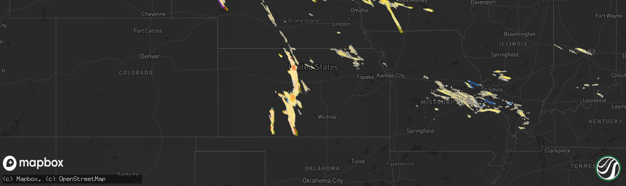
Hail Map in Kansas on July 16, 2023
The weather event in Kansas on July 16, 2023 includes Hail, Wind, and Tornado maps. 21 states and 795 cities were impacted and suffered possible damage. The total estimated number of properties impacted is 30,486.
Hail
Wind
Tornado
30,486
Estimated number of impacted properties by a 1.00" hail or larger21,495
Estimated number of impacted properties by a 1.75" hail or larger10,845
Estimated number of impacted properties by a 2.50" hail or largerStorm reports in Kansas
Kansas
| Date | Description |
|---|---|
| 07/16/20236:55 PM CDT | A local report indicates 1.00 inch wind near Macksville |
| 07/16/20236:50 PM CDT | A local report indicates 70 MPH wind near Larned |
| 07/16/20236:50 PM CDT | A local report indicates 1.00 inch wind near Larned |
| 07/16/20236:35 PM CDT | Report was received from social media. |
| 07/16/20236:30 PM CDT | Report from mping: 3-inch tree limbs broken; power poles broken. |
| 07/16/20236:30 PM CDT | Report from mping of 3-inch tree limbs broken; power poles broken. |
| 07/16/20236:27 PM CDT | Twitter picture sent of ping pong ball sized hail. |
| 07/16/20236:23 PM CDT | Law enforcement reported multiple power poles blown down. |
| 07/16/20236:15 PM CDT | Report sent via twitter of baseball sized hail with one softball sized piece of hail in the yard. Time is based on radar. |
| 07/16/20236:13 PM CDT | Hen egg to tennis ball size at eisenhower school. |
| 07/16/20236:08 PM CDT | Large trees down. 6 inch tree down. Also... Reported quarter size hail. |
| 07/16/20236:08 PM CDT | Report from mping: trees uprooted or snapped; roof blown off. |
| 07/16/20236:08 PM CDT | Large trees down and six inch diameter tree down. Quarter size hail reported as well. |
| 07/16/20236:08 PM CDT | Part of the roof of a church was torn off in town according to a public report relayed via kake and ksn. Time is based on other reports. |
| 07/16/20236:08 PM CDT | Report from mping of trees uprooted or snapped. Roof was blown off. |
| 07/16/20236:02 PM CDT | Report from mping: golf ball |
| 07/16/20236:02 PM CDT | A local report indicates 1.75 inch wind near 2 NE Great Bend |
| 07/16/20236:01 PM CDT | A local report indicates 1.75 inch wind near 2 E Great Bend |
| 07/16/20236:01 PM CDT | Report from mping: golf ball |
| 07/16/20236:01 PM CDT | A local report indicates 1.75 inch wind near 1 ENE Great Bend |
| 07/16/20235:59 PM CDT | Report from mping: golf ball |
| 07/16/20235:59 PM CDT | Numerous power poles completely snapped. Time is estimated. |
| 07/16/20235:59 PM CDT | A local report indicates 1.75 inch wind near 2 ENE Great Bend |
| 07/16/20235:58 PM CDT | 600 block of coolidge. |
| 07/16/20235:58 PM CDT | A local report indicates 1.00 inch wind near 2 E Great Bend |
| 07/16/20235:52 PM CDT | Sustained 45 to 50 mph with gusts of 55 to 60 mph. |
| 07/16/20235:35 PM CDT | Winds were estimated to be 60 to 70 mph. Time is estimated from radar. |
| 07/16/20235:34 PM CDT | Pea to dime size. |
| 07/16/20235:34 PM CDT | Mostly pea to dime sized hail. |
| 07/16/20235:28 PM CDT | Large tree limbs down. |
| 07/16/20235:28 PM CDT | Large tree limbs down. |
| 07/16/20235:25 PM CDT | A local report indicates 77 MPH wind near Russell Airport |
| 07/16/20235:21 PM CDT | A local report indicates 72 MPH wind near Russell Airport |
| 07/16/20235:21 PM CDT | Power lines down blocking the road. |
| 07/16/20235:21 PM CDT | Power lines down blocking the road. |
| 07/16/20235:20 PM CDT | All north windows are broken out at a farm. There are large limbs down as well. Time is estimated. |
| 07/16/20235:17 PM CDT | Semi overturned at mile marker 189 on interstate 70. |
| 07/16/20235:17 PM CDT | Semi overturned at mile marker 189 on interstate 70. |
| 07/16/20235:09 PM CDT | Brief tornado on interstate 70. |
| 07/16/20235:09 PM CDT | 5 power poles knocked on homer road from bunker hill to russell. |
| 07/16/20235:09 PM CDT | 5 power poles knocked down on homer road from bunker hill to russell. |
| 07/16/20235:04 PM CDT | A local report indicates 70 MPH wind near Russell Airport |
| 07/16/20234:58 PM CDT | A local report indicates 1.25 inch wind near 6 SSE Waldo |
| 07/16/20234:44 PM CDT | Time verified by radar. |
| 07/16/20234:44 PM CDT | Penny to quarter size hail... Covered the ground. |
| 07/16/20234:44 PM CDT | Time verified by radar. |
| 07/16/20234:44 PM CDT | Penny to quarter sized hail covered the ground. |
| 07/16/20234:25 PM CDT | Measured 58 mph gust. |
| 07/16/20234:25 PM CDT | A local report indicates 58 MPH wind near Waldo |
| 07/16/20234:19 PM CDT | A local report indicates 65 MPH wind near 10 ENE Natoma |
| 07/16/20234:16 PM CDT | A local report indicates 3.00 inch wind near 7 SSW Osborne |
| 07/16/20234:16 PM CDT | This is a corrected location from the earlier issued 3 inch hail report from 7ssw osborne. Hail size substantiated by emailed photo since posted on facebook and twitter |
| 07/16/20233:35 PM CDT | Delayed report of golf ball size hail that broke windows on home and vehicle and damaged vinyl siding. Time estimated from radar. |
| 07/16/20233:25 PM CDT | Social media report of ping pong ball hail in cedar... Ks. Time estimated from radar. |
| 07/16/20233:19 PM CDT | A local report indicates 1.75 inch wind near Phillipsburg |
| 07/16/20239:09 AM CDT | Relayed report from deputy. |
| 07/15/202310:05 PM CDT | A local report indicates 1.75 inch wind near Lake City |
| 07/15/20239:20 PM CDT | A local report indicates 1.50 inch wind near 3 SE Ford |
| 07/15/20239:13 PM CDT | A local report indicates 1.00 inch wind near 3 SE Ford |
| 07/15/20239:07 PM CDT | Report received from social media with pictures. |
| 07/15/20238:55 PM CDT | Report received from social media. |
| 07/15/20238:51 PM CDT | A local report indicates 1.50 inch wind near 6 NNW Ford |
| 07/15/20238:49 PM CDT | A local report indicates 60 MPH wind near 6 NNW Ford |
| 07/15/20238:40 PM CDT | Report received from social media with pictures. |
| 07/15/20237:42 PM CDT | A local report indicates 1.75 inch wind near 2 W Pratt |
| 07/15/20237:42 PM CDT | Time of event was corrected based on radar. |
| 07/15/20237:30 PM CDT | Report received through social media. |
| 07/15/20237:25 PM CDT | 4 inch tree limbs broken just south of us 54 and wes river road. |
| 07/15/20237:06 PM CDT | 3-inch tree limbs broken... And power poles broken in larned. |
All States Impacted by Hail Map on July 16, 2023
Cities Impacted by Hail Map on July 16, 2023
- Corning, KS
- Centralia, KS
- Goff, KS
- Talco, TX
- Mount Pleasant, TX
- Winfield, TX
- Mount Vernon, TX
- Cookville, TX
- Omaha, TX
- Scroggins, TX
- Leesburg, TX
- Pittsburg, TX
- Ore City, TX
- Daingerfield, TX
- Gilmer, TX
- Naples, TX
- Marietta, TX
- Hughes Springs, TX
- Avinger, TX
- Diana, TX
- Lone Star, TX
- Douglassville, TX
- Linden, TX
- Holdrege, NE
- Funk, NE
- Campbell, TX
- Cumby, TX
- Sulphur Springs, TX
- Havensville, KS
- Soldier, KS
- Colbert, OK
- Spearville, KS
- Emmett, KS
- Burchard, NE
- Axtell, KS
- Summerfield, KS
- Paris, TX
- Hanover, KS
- Point, TX
- Emory, TX
- Longview, TX
- Clatonia, NE
- Cortland, NE
- Hallam, NE
- Wetmore, KS
- Mill Creek, OK
- Mannsville, OK
- Riverdale, NE
- Windom, TX
- Honey Grove, TX
- Ben Franklin, TX
- Pecan Gap, TX
- Ladonia, TX
- Klondike, TX
- Cooper, TX
- Roxton, TX
- Bennington, OK
- Walters, OK
- Geronimo, OK
- Sumner, TX
- Arthur City, TX
- Holton, KS
- Pawnee City, NE
- Platte City, MO
- Dearborn, MO
- Weston, MO
- Telephone, TX
- Winnsboro, TX
- Waterville, KS
- Bremen, KS
- Home, KS
- Marysville, KS
- Onaga, KS
- Frankfort, KS
- Duncan, OK
- Quitman, TX
- Mineola, TX
- Alba, TX
- Blue Rapids, KS
- Powderly, TX
- Baileyville, KS
- Springer, OK
- Westville, FL
- Ponce De Leon, FL
- Hendrix, OK
- Delia, KS
- Vermillion, KS
- Ravenna, TX
- Petty, TX
- Ivanhoe, TX
- Arlington, TX
- Fort Worth, TX
- Beattie, KS
- Seneca, KS
- Wolfe City, TX
- Commerce, TX
- Wills Point, TX
- Davis, OK
- Bokchito, OK
- Savoy, TX
- Hollenberg, KS
- Oketo, KS
- Morrowville, KS
- Washington, KS
- Jefferson, TX
- Harleton, TX
- Marshall, TX
- Karnack, TX
- Bivins, TX
- Mooringsport, LA
- Waskom, TX
- Shreveport, LA
- Oil City, LA
- Belcher, LA
- Vivian, LA
- Blanchard, LA
- Warrenton, MO
- Wright City, MO
- Foristell, MO
- Wentzville, MO
- Marthasville, MO
- Haughton, LA
- Minden, LA
- Benton, LA
- Bossier City, LA
- Cotton Valley, LA
- Barksdale Afb, LA
- Princeton, LA
- Doyline, LA
- Defiance, MO
- O'Fallon, MO
- Lake Saint Louis, MO
- Kensington, KS
- Agra, KS
- Athol, KS
- Gaylord, KS
- Cedar, KS
- Phillipsburg, KS
- Sibley, LA
- Jamestown, LA
- Dubberly, LA
- Heflin, LA
- Homer, LA
- Athens, LA
- Arcadia, LA
- Dubach, LA
- Gibsland, LA
- Simsboro, LA
- Bienville, LA
- Quitman, LA
- Ruston, LA
- Shipman, IL
- Carlinville, IL
- Festus, MO
- Hillsboro, MO
- Pevely, MO
- Herculaneum, MO
- Osborne, KS
- Portis, KS
- Alton, KS
- Glade, KS
- Valmeyer, IL
- Crystal City, MO
- Prairie Du Rocher, IL
- Fults, IL
- Red Bud, IL
- Grambling, LA
- Farmerville, LA
- Choudrant, LA
- Downsville, LA
- Calhoun, LA
- Chatham, LA
- Eros, LA
- West Monroe, LA
- Waldo, KS
- Natoma, KS
- Columbia, LA
- Luray, KS
- Paradise, KS
- Lucas, KS
- Russell, KS
- Bunker Hill, KS
- Dorrance, KS
- Sorento, IL
- Walshville, IL
- Panama, IL
- Donnellson, IL
- Greenville, IL
- Wilson, KS
- Oelrichs, SD
- Chadron, NE
- Pine Ridge, SD
- Lebanon, IN
- Brownsburg, IN
- Zionsville, IN
- Pittsboro, IN
- Whitestown, IN
- Indianapolis, IN
- Hay Springs, NE
- Hoisington, KS
- Claflin, KS
- Holyrood, KS
- Great Bend, KS
- Ellinwood, KS
- Bison, KS
- Otis, KS
- Rush Center, KS
- Albert, KS
- Olmitz, KS
- Pawnee Rock, KS
- St John, KS
- Larned, KS
- Wounded Knee, SD
- Batesland, SD
- Manderson, SD
- Stover, MO
- Covington, IN
- Perrysville, IN
- Buffalo, MO
- Meta, MO
- Abita Springs, LA
- Covington, LA
- Herrin, IL
- Johnston City, IL
- Marion, IL
- Jena, LA
- Jonesville, LA
- Bland, MO
- Mount Sterling, MO
- Owensville, MO
- Hermann, MO
- Morrison, MO
- Ringgold, LA
- Mount Olive, IL
- Stoutland, MO
- Montreal, MO
- Kilgore, TX
- Dodson, LA
- Rocky Mount, MO
- Eldon, MO
- Como, TX
- Fidelity, IL
- Piasa, IL
- Brighton, IL
- Magnolia, AR
- Bogalusa, LA
- Quincy, MO
- Wheatland, MO
- Campti, LA
- Natchitoches, LA
- Edgemont, SD
- Nacogdoches, TX
- Franklinton, LA
- Kiln, MS
- Tullos, LA
- Jewell, KS
- Amite, LA
- Vancleave, MS
- Carmel, IN
- Lebanon, KS
- Smith Center, KS
- Phillips, WI
- Kentwood, LA
- Springhill, LA
- Taylor, AR
- Russellville, MO
- Barnett, MO
- Randall, KS
- Jamestown, KS
- Beloit, KS
- Moss Point, MS
- Belle, MO
- Sainte Genevieve, MO
- Castor, LA
- Saint Thomas, MO
- Henley, MO
- Tuscumbia, MO
- Logansport, LA
- Jupiter, FL
- Hobe Sound, FL
- Mansfield, LA
- Osyka, MS
- Freeburg, MO
- Argyle, MO
- Koeltztown, MO
- Jefferson City, MO
- Saint Elizabeth, MO
- Eugene, MO
- Westphalia, MO
- Staunton, IL
- Phillipsburg, MO
- Jeanerette, LA
- Baldwin, LA
- Franklin, LA
- Coushatta, LA
- Jonesburg, MO
- Cuba, MO
- Ashland, LA
- Sullivan, MO
- Richwoods, MO
- Lonedell, MO
- Netawaka, KS
- Glenmora, LA
- Joaquin, TX
- Grand Cane, LA
- Lisbon, LA
- Litchfield, IL
- Marksville, LA
- Hawkins, TX
- New Iberia, LA
- Delcambre, LA
- Madisonville, LA
- Glasco, KS
- Simpson, KS
- Sarepta, LA
- Plain Dealing, LA
- Magnolia, MS
- Centreville, MS
- Olla, LA
- Trout, LA
- Harrisonburg, LA
- New Douglas, IL
- Leasburg, MO
- Riverton, NE
- Carriere, MS
- Picayune, MS
- Cairo, GA
- Whigham, GA
- Robertsville, MO
- Belle Rose, LA
- Richland, MO
- Sikes, LA
- Hineston, LA
- Lettsworth, LA
- Bourbon, MO
- Bainbridge, GA
- Climax, GA
- Linn, MO
- Loose Creek, MO
- Damascus, GA
- Hallsville, TX
- Independence, LA
- Greenville, FL
- Monterey, LA
- Dittmer, MO
- Catawissa, MO
- Cedar Hill, MO
- Woodbine, GA
- Poplarville, MS
- Potosi, MO
- Goldonna, LA
- Natchez, MS
- Versailles, MO
- Olean, MO
- Gillespie, IL
- Butler, IL
- Chesterfield, IL
- Medora, IL
- Greensburg, LA
- Saint Charles, MO
- Saint Peters, MO
- Ponchatoula, LA
- Hammond, LA
- Pollock, LA
- Glen Elder, KS
- Pittsburg, IL
- Bush, LA
- Bunker Hill, IL
- Pocahontas, IL
- Worden, IL
- Livingston, IL
- Alhambra, IL
- Fayette, MS
- Union Church, MS
- Pattison, MS
- Lorman, MS
- Macksville, KS
- Belpre, KS
- Hazlehurst, MS
- Hermanville, MS
- Alliance, NE
- Ellsworth, NE
- Gordon, NE
- Merriman, NE
- Byers, KS
- Iuka, KS
- Pratt, KS
- Haviland, KS
- Lakeside, NE
- Bingham, NE
- Oshkosh, NE
- Coats, KS
- Sawyer, KS
- Nekoma, KS
- Ashby, NE
- Sun City, KS
- Medicine Lodge, KS
- Lewellen, NE
- Arthur, NE
- Lemoyne, NE
- Farmington, CT
- West Hartford, CT
- New Britain, CT
- Newington, CT
- Hartford, CT
- Wethersfield, CT
- East Hartford, CT
- Windsor, CT
- South Windsor, CT
- Berlin, CT
- Rocky Hill, CT
- East Berlin, CT
- Cromwell, CT
- Glastonbury, CT
- South Glastonbury, CT
- Manchester, CT
- Vernon Rockville, CT
- Bolton, CT
- Coventry, CT
- Stafford Springs, CT
- Tolland, CT
- Ellington, CT
- Willington, CT
- Storrs Mansfield, CT
- Keystone, NE
- Offerle, KS
- Bucklin, KS
- Ford, KS
- Lewis, KS
- Hudson, KS
- Sylvia, KS
- Lake City, KS
- Minneola, KS
- Ashland, KS
- Hardtner, KS
- Kiowa, KS
- Creal Springs, IL
- Fort Necessity, LA
- Winnsboro, LA
- Duson, LA
- Lafayette, LA
- Muscoda, WI
- Boscobel, WI
- Kingman, IN
- Veedersburg, IN
- Saint Marys, KS
- Mobile, AL
- Eight Mile, AL
- Dequincy, LA
- Ragley, LA
- New Ross, IN
- Ladoga, IN
- Roachdale, IN
- North Salem, IN
- Crawfordsville, IN
- Marshall, IN
- Greenfield, IN
- Ellsworth, KS
- Lorraine, KS
- Tallulah, LA
- Newellton, LA
- Rushville, NE
- Golconda, IL
- Simpson, IL
- Vienna, IL
- Waupaca, WI
- Amherst, WI
- Merrimac, WI
- North Freedom, WI
- Lodi, WI
- Baraboo, WI
- Prairie Du Sac, WI
- Circleville, KS
- Roxie, MS
- Campbellsburg, IN
- Clayton, LA
- Lake Charles, LA
- Mccordsville, IN
- Ferriday, LA
- Vicksburg, MS
- Sicily Island, LA
- Gilbert, LA
- West Frankfort, IL
- Carterville, IL
- Stonefort, IL
- Energy, IL
- Fort Lauderdale, FL
- Lucedale, MS
- Kanopolis, KS
- Sylvan Grove, KS
- Loganville, WI
- Plain, WI
- Woodville, MS
- Reeves, LA
- Wesson, MS
- Geneseo, KS
- Porterfield, WI
- Wallace, MI
- Neenah, WI
- Kinder, LA
- Mitchell, IN
- Orleans, IN
- Richland Center, WI
- Soldiers Grove, WI
- Blue River, WI
- Hillpoint, WI
- Rayne, LA
- Gays Mills, WI
- Cazenovia, WI
- Jennings, LA
- Sawyerville, IL
- Enterprise, LA
- Reedsville, WI
- Abbeville, LA
- Maurice, LA
- New Burnside, IL
- Menasha, WI
- Larsen, WI
- Loxley, AL
- Bay Minette, AL
- Stapleton, AL
- Broxton, GA
- Aimwell, LA
- Jamestown, IN
- Eddyville, IL
- Eden, WI
- Pepperell, MA
- Townsend, MA
- Hollis, NH
- Brookline, NH
- Merrimack, NH
- Nashua, NH
- Amherst, NH
- Bloomfield, CT
- Kimballton, IA
- Audubon, IA
- Elk Horn, IA
- Exira, IA
- Brayton, IA
- Anita, IA
- Stuart, IA
- Menlo, IA
- Sauk City, WI
- Poynette, WI
- Arlington, WI
- Fond Du Lac, WI
- Winterset, IA
- Earlham, IA
- Dexter, IA
- Saint Cloud, WI
- Campbellsport, WI
- Mount Calvary, WI
- Glenbeulah, WI
- Persia, IA
- Shelby, IA
- Avoca, IA
- Columbia, IL
- Saint Charles, IA
- Prole, IA
- Bevington, IA
- Indianola, IA
- Atlantic, IA
- Blackwell, MO
- De Soto, MO
- Coulterville, IL
- Pinckneyville, IL
- Tamaroa, IL
- Du Quoin, IL
- California, MO
- Lohman, MO
- Centertown, MO
- Marshall, MO
- Harlan, IA
- Oconto, NE
- Portsmouth, IA
- Lexington, NE
- Callaway, NE
- Danville, IN
- Eddyville, NE
- Campbell Hill, IL
- McCracken, KS
- Alexander, KS
- Deputy, IN
- Scottsburg, IN
- Woodbine, IA
- Panama, IA
- Gerald, MO
- Rosebud, MO
- New Bloomfield, MO
- Arnold, NE
- Saint Louis, MO
- Chamois, MO
- Vallonia, IN
- Tebbetts, MO
- Austin, IN
- Salem, IN
- Galatia, IL
- Downs, KS
- High Ridge, MO
- Eureka, MO
- House Springs, MO
- Rio Grande City, TX
- Wilcox, NE
- Leslie, MO
- Beaufort, MO
- Stafford, KS
- Saint Clair, MO
- Goshen, KY
- Charlestown, IN
- Union, MO
- Marissa, IL
- Adair, IA
- Hartsburg, MO
- Jamestown, MO
- Boonville, MO
- Columbia, MO
- Wooldridge, MO
- Prairie Home, MO
- Ashland, MO
- Bonnots Mill, MO
- Holts Summit, MO
- Mulkeytown, IL
- Turon, KS
- Comanche, OK
- Bloomsdale, MO
- North Vernon, IN
- Vernon, IN
- New Athens, IL
- Imperial, MO
- Pacific, MO
- Ballwin, MO
- Fenton, MO
- Freeburg, IL
- Waterloo, IL
- Millstadt, IL
- East Carondelet, IL
- Wildwood, MO
- Arnold, MO
- Valley Park, MO
- Belleville, IL
- Smithton, IL
- Sherwood, WI
- New Haven, MO
- New Palestine, IN
- Brownstown, IN
- Crestwood, KY
- Buckner, KY
- La Grange, KY
- Marysville, IN
- Nabb, IN
- Otisco, IN
- Percy, IL
- Cutler, IL
- Sesser, IL
- Nelson, MO
- Blackwater, MO
- Wright, KS
- Dodge City, KS
- Crothersville, IN
- Hamlin, IA
- Fontanelle, IA
- Bridgewater, IA
- Soldier, IA
- Moorhead, IA
- Dunlap, IA
- Logan, IA
- Neola, IA
- Minden, IA
- Herman, NE
- Tekamah, NE
- Craig, NE
- Blair, NE
- Greenfield, IA
- Creston, IA
- Prescott, IA
- Orient, IA
- Saint Mary, MO
- Elgin, NE
- Petersburg, NE
- Albion, NE
- Cromwell, IA
- Newman Grove, NE
- Lenox, IA
- Shannon City, IA
- Perryville, MO
- Decatur, NE
- Lindsay, NE
- Laurel, NE
- Dixon, NE
- Coleridge, NE
- Diagonal, IA
- Mount Ayr, IA
- Saint Edward, NE
- Madison, NE
- Humphrey, NE
- Wayne, NE
- Concord, NE
- Blencoe, IA
- Little Sioux, IA
- Knoxville, IA
- Harvey, IA
- Tracy, IA
- Bussey, IA
- Oskaloosa, IA
- Creston, NE
- Wakefield, NE
- Eddyville, IA
- Leighton, IA
- Leigh, NE
- Hatfield, MO
- Eagleville, MO
- Martinsville, MO
- Kellerton, IA
- Franklin, NE
- Bloomington, NE
- Pisgah, IA
- Marne, IA
- Wiota, IA
- Kiron, IA
- Vail, IA
- Deloit, IA
- Arcadia, IA
- Breda, IA
- Westside, IA
- Gray, IA
- Manning, IA
- Manilla, IA
- Casey, IA
- Aspinwall, IA
- Irwin, IA
- Naponee, NE
- Hildreth, NE
- Oakland, NE
- Karnak, IL
- Belknap, IL
- Boss, MO
- Davisville, MO
- Ellis Grove, IL
- Walsh, IL
- Platte Center, NE
- Bonne Terre, MO
- Park Hills, MO
- Leadwood, MO
- Mineral Point, MO
- Central City, NE
- Marquette, NE
- Hordville, NE
- Lyons, NE
- Royalton, IL
- Freeman Spur, IL
- Orient, IL
- Zeigler, IL
- Steelville, MO
- Raleigh, IL
- Irondale, MO
- Farmington, MO
- French Village, MO
- Cadet, MO
- Elkville, IL
- Vergennes, IL
- Saint Marys, IA
- Patterson, IA
- Viburnum, MO
- Bixby, MO
- Cypress, IL
- Sumner, NE
- Broken Bow, NE
- Overton, NE
- Onawa, IA
- Belgrade, MO
- Columbus, NE
- Saint James, MO
- Whittington, IL
- Benton, IL
- Scheller, IL
- Chester, IL
- Vichy, MO
- Vienna, MO
- Fletcher, MO
- Axtell, NE
- Elm Creek, NE
- Hancock, IA
- Missouri Valley, IA
- Anselmo, NE
- Hampton, NE
- Bradshaw, NE
- Polk, NE
- Mondamin, IA
- Stanton, NE
- Norfolk, NE
- Massena, IA
- Tingley, IA
- Kirkman, IA
- Fulton, MO
- Redfield, IA


