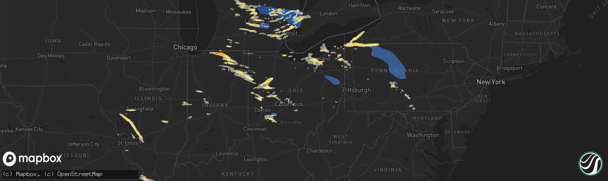
Hail Map in Ohio on July 20, 2023
The weather event in Ohio on July 20, 2023 includes Hail, Wind, and Tornado maps. 22 states and 1,246 cities were impacted and suffered possible damage. The total estimated number of properties impacted is 116,106.
Hail
Wind
Tornado
116,106
Estimated number of impacted properties by a 1.00" hail or larger28,767
Estimated number of impacted properties by a 1.75" hail or larger0
Estimated number of impacted properties by a 2.50" hail or largerStorm reports in Ohio
Ohio
| Date | Description |
|---|---|
| 07/20/20236:58 PM CDT | Tree down on boneta rd between route 18 and ridgewood. |
| 07/20/20236:55 PM CDT | Tree down. Time estimated from radar. |
| 07/20/20236:54 PM CDT | Multiple trees down. Time estimated from radar. |
| 07/20/20236:50 PM CDT | Tree downed onto road in brunswick. Time estimated via radar. |
| 07/20/20236:50 PM CDT | Reports of several trees down across howland township. |
| 07/20/20236:50 PM CDT | Tree down onto park ledge drive. |
| 07/20/20236:49 PM CDT | A local report indicates 1.00 inch wind near 1 ESE Parma |
| 07/20/20236:49 PM CDT | Two trees downed across road near bloomville. Time estimated via radar. |
| 07/20/20236:49 PM CDT | . |
| 07/20/20236:45 PM CDT | Report from mping: ping pong ball |
| 07/20/20236:41 PM CDT | A few downed trees and power outages reported in the new london area. Time estimated via radar. |
| 07/20/20236:40 PM CDT | Corrects previous hail report from 1 ese parma. |
| 07/20/20236:40 PM CDT | Report from mping: half dollar |
| 07/20/20236:34 PM CDT | Large section of tree downed on n center street. One power pole broken. Time estimated from radar. |
| 07/20/20236:27 PM CDT | Trees and power lines down. Time estimated from radar. |
| 07/20/20236:27 PM CDT | Tree downed. Time estimated via radar. |
| 07/20/20236:26 PM CDT | Nickel to quarter sized hail at nws cleveland office. |
| 07/20/20236:25 PM CDT | 1.5 inch hail. |
| 07/20/20236:22 PM CDT | Large tree limb down 4 miles northwest of mantua. Time estimated via radar. |
| 07/20/20236:20 PM CDT | Retired nws employee reports 1 and a half inch hail in parma. |
| 07/20/20236:20 PM CDT | Large tree branch on west 54th. |
| 07/20/20236:18 PM CDT | Quarter to golf ball-sized hail in parma and parma heights. |
| 07/20/20236:11 PM CDT | Large tree branch snapped at lakewood park. |
| 07/20/20236:05 PM CDT | Report from mping: quarter |
| 07/20/20236:05 PM CDT | A local report indicates 2.00 inch wind near Westlake |
| 07/20/20236:05 PM CDT | Two trees down in north olmsted. |
| 07/20/20236:04 PM CDT | Report from mping: quarter |
| 07/20/20236:00 PM CDT | Report forwarded via social media. |
| 07/20/20235:57 PM CDT | Report from mping: quarter |
| 07/20/20235:56 PM CDT | A local report indicates 1.00 inch wind near Avon |
| 07/20/20235:54 PM CDT | Social media photo of measured hail stones. |
| 07/20/20235:52 PM CDT | Two trees down on a house. Time estimated from radar. |
| 07/20/20235:50 PM CDT | Report from mping: quarter |
| 07/20/20235:46 PM CDT | A few tree limbs down on jefferson street. |
| 07/20/20235:45 PM CDT | Emergency manager reports numerous trees down between wren... Oh and ohio city... Oh. |
| 07/20/20235:45 PM CDT | Emergency manaille cattaraugus ny 4234 7845 tree down in the village of franklinville. |
| 07/20/20235:43 PM CDT | Tree down on north main street in rockford. |
| 07/20/20235:42 PM CDT | Large branch down. Time estimated from radar. |
| 07/20/20235:40 PM CDT | Tree down on house on auburn rd. |
| 07/20/20235:39 PM CDT | Trees down. Time estimated from radar. |
| 07/20/20235:33 PM CDT | Report from mping: half dollar |
| 07/20/20235:32 PM CDT | -delayed report- multiple large limbs and trees down in conneaut... Some onto roadways. |
| 07/20/20235:31 PM CDT | Tree down on house. Time estimated from radar. |
| 07/20/20235:30 PM CDT | Buoy station faio1 fairport... Oh. |
| 07/20/20235:30 PM CDT | A local report indicates 1.25 inch wind near Harrod |
| 07/20/20235:30 PM CDT | Trees down. Time estimated from radar. |
| 07/20/20235:28 PM CDT | -delayed report- tree limbs downed in painesville. |
| 07/20/20235:27 PM CDT | Widespread tree damage in fairport harbor. Time estimated via radar. |
| 07/20/20235:27 PM CDT | -delayed report- siding partially peeled off the second story of a house in fairport harbor. |
| 07/20/20235:24 PM CDT | Emergency manager reports tree down on a house in ohio city in van wert county. One person injured and trapped. Also powerlines down in ohio city as well. |
| 07/20/20235:24 PM CDT | Corrects previous tstm wnd dmg report from ohio city to update number of injuries. Emergency manager reports tree down on a house in ohio city in van wert county. Two p |
| 07/20/20235:24 PM CDT | *** 1 fatal *** corrects previous tstm wnd dmg report from ohio city. 1 fatality confirmed. Second occupant not injured. Emergency manager reports tree down on an overh |
| 07/20/20235:18 PM CDT | Asos station ktdz toledo. |
| 07/20/20235:18 PM CDT | Buoy station faio1 fairport... Oh. |
| 07/20/20235:18 PM CDT | Power pole snapped and hit a car... Large tree branch on wires near the yacht club and large tree uprooted. |
| 07/20/20235:18 PM CDT | -delayed report- two pictures received on social media of a tree and large limb downed on cars in separate residential driveways in mentor. |
| 07/20/20235:17 PM CDT | Tree limb and power line downed. Time estimated via radar. |
| 07/20/20235:17 PM CDT | -delayed report- numerous reports from a retired nws employee... Broadcast meteorologist... And the public of widespread... Extensive tree and power-line damage in ment |
| 07/20/20235:05 PM CDT | Trees down. Time estimated from radar. |
| 07/20/20234:40 PM CDT | Report from mping: half dollar |
| 07/20/20234:39 PM CDT | Report from mping: quarter |
| 07/20/20234:07 PM CDT | Large tree down in kunkle. Time estimated via radar. |
| 07/20/20233:57 PM CDT | Report from mping: half dollar |
| 07/19/20239:18 PM CDT | 2 trees down. Time estimated from radar. |
| 07/19/20239:04 PM CDT | Tree down. Time estimated from radar. |
| 07/19/20238:55 PM CDT | One large tree downed on w main street. Time estimated from radar. |
| 07/19/20238:45 PM CDT | Tree down on annesley road. |
| 07/19/20238:41 PM CDT | Numerous branches on atioch road... Trees down. Time estimated from radar. |
| 07/19/20238:41 PM CDT | Trees down. Time estimated from radar. |
| 07/19/20238:39 PM CDT | Tree down. |
| 07/19/20238:38 PM CDT | Tree down on state route 164 and spring valley road. |
| 07/19/20238:38 PM CDT | Tree down. |
| 07/19/20238:38 PM CDT | Roof damage to a barn. |
| 07/19/20238:30 PM CDT | Numerous trees down along old state route 73. |
| 07/19/20238:26 PM CDT | Trees and wires down. Time estimated from radar. |
| 07/19/20238:25 PM CDT | A local report indicates 71 MPH wind near 2 ESE Wilmington |
| 07/19/20238:25 PM CDT | Tree down on route 45 and route 558. |
| 07/19/20238:24 PM CDT | Tree down on gamble road. |
| 07/19/20238:12 PM CDT | Large branch down. Time estimated from radar. |
| 07/19/20238:09 PM CDT | Trees down on power lines. Time estimated from radar. |
| 07/19/20238:07 PM CDT | Trees down. Time estimated from radar. |
| 07/19/20238:02 PM CDT | Fallen tree onto roof of house. |
| 07/19/20238:00 PM CDT | Scattered tree damage across knox county... Especially western and southwestern portions of the county. Time estimated via radar. |
| 07/19/20237:58 PM CDT | Large branch and wires down near fisher and hague roads. Time estimated from radar. |
| 07/19/20237:47 PM CDT | Trees down and telephone poles snapped. Time estimated from radar. |
| 07/19/20237:40 PM CDT | Several trees down and blocking roads in new franklin. |
| 07/19/20237:40 PM CDT | Numerous large tree limbs down - time estimated from radar. |
| 07/19/20237:38 PM CDT | Trees down along u.s. 23 in delaware. |
| 07/19/20237:38 PM CDT | Tree limb downed onto road in the mechanicsburg/wayne twp area. A few other wires reported downed in the county. Time estimated via radar. |
| 07/19/20237:21 PM CDT | Three cars submerged in water at w117 and berea rd. |
| 07/19/20237:10 PM CDT | Numerous branches down - time estimated by radar. |
| 07/19/20237:10 PM CDT | Large red oak tree snapped 15-20 ft up and fell on house. |
| 07/19/20237:08 PM CDT | Trees down countywide. Time estimated from radar. |
| 07/19/20237:07 PM CDT | A few trees and wires downed onto roadways between nova and nankin. Time estimated via radar. |
| 07/19/20237:07 PM CDT | A few trees and wires downed onto roadways between nova and nankin. Time estimated via radar. |
| 07/19/20237:02 PM CDT | Tree down on yellow creek rd near sand run rd. |
| 07/19/20237:00 PM CDT | Several trees/wires down across liberty township. |
All States Impacted by Hail Map on July 20, 2023
Cities Impacted by Hail Map on July 20, 2023
- Bonne Terre, MO
- Farmington, MO
- Roodhouse, IL
- White Hall, IL
- Greenfield, IL
- Hettick, IL
- New Berlin, IL
- Carlinville, IL
- Shipman, IL
- Gillespie, IL
- Paducah, KY
- Brookport, IL
- Ledbetter, KY
- Gilbertsville, KY
- Smithland, KY
- Calvert City, KY
- Grand Rivers, KY
- Kuttawa, KY
- Eddyville, KY
- Sterling, CO
- Iliff, CO
- Princeton, KY
- Cadiz, KY
- Cerulean, KY
- Gracey, KY
- Crofton, KY
- Hopkinsville, KY
- Fleming, CO
- Pembroke, KY
- Trenton, KY
- Elkton, KY
- Guthrie, KY
- Clarksville, TN
- Allensville, KY
- Adams, TN
- Olmstead, KY
- Springfield, TN
- Cedar Hill, TN
- Adairville, KY
- Greenbrier, TN
- White House, TN
- Goodlettsville, TN
- Hendersonville, TN
- Cottontown, TN
- Madison, TN
- Gallatin, TN
- Bannister, MI
- Brant, MI
- Elsie, MI
- Ashley, MI
- Oakley, MI
- Henderson, MI
- Chesaning, MI
- Old Hickory, TN
- Mount Juliet, TN
- Lebanon, TN
- Hermitage, TN
- Stewart, TN
- Metropolis, IL
- Jacksonville, IL
- Murrayville, IL
- Carlyle, IL
- Winchester, IL
- Sheridan, MI
- French Village, MO
- Sedgewickville, MO
- Friedheim, MO
- Perryville, MO
- Greenville, MI
- Edwardsville, IL
- Padroni, CO
- Waterloo, IL
- Grand Chain, IL
- Sainte Genevieve, MO
- Saint Mary, MO
- Stanton, MI
- Hersey, MI
- Reed City, MI
- Evart, MI
- Oak Ridge, MO
- Daisy, MO
- Patton, MO
- Ullin, IL
- Olmsted, IL
- Kevil, KY
- Pulaski, IL
- Alexander, IL
- Jackson, MO
- Cape Girardeau, MO
- Jonesboro, IL
- McClure, IL
- Lake City, PA
- East Springfield, PA
- Girard, PA
- Osage Beach, MO
- Kaiser, MO
- Linn Creek, MO
- Thebes, IL
- Tamms, IL
- Kirk, CO
- Lakeview, MI
- Pocahontas, IL
- Crossville, TN
- Oak Grove, KY
- Pentwater, MI
- Ludington, MI
- Orlinda, TN
- Benld, IL
- Chesterfield, IL
- Sidney, MI
- Fredericktown, MO
- Russellville, KY
- Howard City, MI
- Morley, MI
- Fort Campbell, KY
- Potosi, MO
- Alhambra, IL
- Livingston, IL
- Staunton, IL
- New Douglas, IL
- Baxter, TN
- Gowen, MI
- De Soto, MO
- Valles Mines, MO
- Aviston, IL
- Festus, MO
- Bloomsdale, MO
- Rockford, MI
- Merino, CO
- Lake, MI
- Breese, IL
- Highland, IL
- Palmyra, IL
- Sawyerville, IL
- Mount Olive, IL
- Golden Eagle, IL
- Bunker Hill, IL
- Wilsonville, IL
- Fenwick, MI
- Vestaburg, MI
- Six Lakes, MI
- Coral, MI
- Newaygo, MI
- Trufant, MI
- White Cloud, MI
- Crystal, MI
- Moro, IL
- Mounds, IL
- Olive Branch, IL
- Villa Ridge, IL
- Brumley, MO
- La Center, KY
- Barlow, KY
- Dongola, IL
- West Paducah, KY
- Karnak, IL
- Cypress, IL
- Stoneham, CO
- Park Hills, MO
- Murfreesboro, TN
- New Lothrop, MI
- Owosso, MI
- Montrose, MI
- Corunna, MI
- Dewitt, MI
- Bath, MI
- Laingsburg, MI
- Flint, MI
- Clio, MI
- Flushing, MI
- Lennon, MI
- Swartz Creek, MI
- Mount Morris, MI
- Fairview, PA
- Erie, PA
- McKean, PA
- Harborcreek, PA
- North East, PA
- Ripley, NY
- Burton, MI
- Davison, MI
- Genesee, MI
- Schoolcraft, MI
- Vicksburg, MI
- Lapeer, MI
- Lascassas, TN
- Auburntown, TN
- Watertown, TN
- Milton, TN
- Liberty, TN
- Alexandria, TN
- Dowelltown, TN
- Smithville, TN
- Woodbury, TN
- Readyville, TN
- Mcminnville, TN
- Bradyville, TN
- Morrison, TN
- Saint Johns, MI
- Ovid, MI
- Durand, MI
- Holt, MI
- Leslie, MI
- Mason, MI
- Dansville, MI
- Williamston, MI
- Webberville, MI
- Fowlerville, MI
- Stockbridge, MI
- Brighton, MI
- Gregory, MI
- Howell, MI
- Pinckney, MI
- Capac, MI
- Imlay City, MI
- Allenton, MI
- Almont, MI
- Dryden, MI
- Otisville, MI
- Grand Blanc, MI
- Goodrich, MI
- Atlas, MI
- Oxford, MI
- Metamora, MI
- Hadley, MI
- Ortonville, MI
- Columbiaville, MI
- Detroit, MI
- Highland Park, MI
- Ferndale, MI
- Warren, MI
- Hamtramck, MI
- Hazel Park, MI
- South Bend, IN
- Mishawaka, IN
- Osceola, IN
- Eastpointe, MI
- Saint Clair Shores, MI
- Roseville, MI
- Harper Woods, MI
- Avoca, MI
- Emmett, MI
- Jeddo, MI
- North Street, MI
- Clinton Township, MI
- Harrison Township, MI
- Elkhart, IN
- Goshen, IN
- Clarkston, MI
- Rock Island, TN
- Fort Gratiot, MI
- Center Line, MI
- Bennett, CO
- Columbus, MI
- Saint Clair, MI
- Casco, MI
- East China, MI
- Marysville, MI
- Divide, CO
- Woodland Park, CO
- Green Mountain Falls, CO
- Cascade, CO
- Colorado Springs, CO
- Attica, MI
- Romeo, MI
- Washington, MI
- Leonard, MI
- Rochester, MI
- Oakland, MI
- Ray, MI
- Macomb, MI
- Utica, MI
- Armada, MI
- New Baltimore, MI
- New Haven, MI
- Harsens Island, MI
- Fair Haven, MI
- Algonac, MI
- Marine City, MI
- Richmond, MI
- Smiths Creek, MI
- Goodells, MI
- Memphis, MI
- Yale, MI
- Port Huron, MI
- Manitou Springs, CO
- Middlebury, IN
- Millersburg, IN
- Elizabeth, CO
- Albion, PA
- Cranesville, PA
- Edinboro, PA
- Kiowa, CO
- West Springfield, PA
- Ypsilanti, MI
- Ann Arbor, MI
- Canton, MI
- Belleville, MI
- Wayne, MI
- Dexter, MI
- Chelsea, MI
- Peyton, CO
- Elbert, CO
- Strasburg, CO
- Byers, CO
- Fort Morgan, CO
- Calhan, CO
- Ramah, CO
- Wallace, KS
- Sharon Springs, KS
- Leoti, KS
- Winona, KS
- Marienthal, KS
- Scott City, KS
- Simla, CO
- Boncarbo, CO
- Trinidad, CO
- Waterford, PA
- Holcomb, KS
- Garden City, KS
- Deerfield, KS
- Yoder, CO
- Union City, PA
- Walsenburg, CO
- Lakin, KS
- Wakeman, OH
- Oberlin, OH
- Chardon, OH
- Brookpark, OH
- Montville, OH
- Norwalk, OH
- Jefferson, OH
- Wellington, OH
- Beachwood, OH
- Grafton, OH
- New London, OH
- Kingsville, OH
- Independence, OH
- Berea, OH
- Springboro, PA
- Rock Creek, OH
- Pierpont, OH
- North Fairfield, OH
- Lagrange, OH
- Conneaut, OH
- Gates Mills, OH
- Olmsted Falls, OH
- Chesterland, OH
- Collins, OH
- Cleveland, OH
- Thompson, OH
- Columbia Station, OH
- Martin, OH
- Graytown, OH
- Oak Harbor, OH
- Curtice, OH
- Matheson, CO
- Denver, CO
- Morrison, CO
- Golden, CO
- Ingalls, KS
- Wattsburg, PA
- Littleton, CO
- Englewood, CO
- Canon City, CO
- Penrose, CO
- Fort Wayne, IN
- Yoder, IN
- Hoagland, IN
- Decatur, IN
- Monroeville, IN
- Ohio City, OH
- Convoy, OH
- Van Wert, OH
- Rush, CO
- Fowler, CO
- Chatsworth, GA
- Dalton, GA
- Ellijay, GA
- Calhoun, GA
- Resaca, GA
- Ranger, GA
- Talking Rock, GA
- Fairmount, GA
- Waleska, GA
- Jasper, GA
- Ball Ground, GA
- Canton, GA
- Alpharetta, GA
- Tate, GA
- Suwanee, GA
- Gainesville, GA
- Marble Hill, GA
- Dawsonville, GA
- Flowery Branch, GA
- Cumming, GA
- Buford, GA
- Corry, PA
- Cimarron, KS
- Florence, CO
- Wapakoneta, OH
- Lima, OH
- Manzanola, CO
- Harrod, OH
- Lafayette, OH
- Ada, OH
- Alger, OH
- Ordway, CO
- Hugo, CO
- Roggen, CO
- Mentor, OH
- Painesville, OH
- Grand River, OH
- Bluffton, OH
- Pueblo, CO
- Forest, OH
- Dunkirk, OH
- Sugar City, CO
- Rocky Ford, CO
- Olney Springs, CO
- Oakwood, GA
- Pendergrass, GA
- Talmo, GA
- Hoschton, GA
- Braselton, GA
- Jefferson, GA
- Dacula, GA
- Auburn, GA
- Lawrenceville, GA
- Winder, GA
- Statham, GA
- Bogart, GA
- Athens, GA
- Watkinsville, GA
- Colbert, GA
- Arnoldsville, GA
- Lexington, GA
- Crawford, GA
- Winterville, GA
- Nicholson, GA
- Lakeview, OH
- Huntsville, OH
- Belle Center, OH
- La Junta, CO
- Roundhead, OH
- Karval, CO
- Columbus, PA
- Bear Lake, PA
- Spring Creek, PA
- Youngsville, PA
- Pittsfield, PA
- Sugar Grove, PA
- Warren, PA
- Dodge City, KS
- Wright, KS
- Avon, OH
- Westlake, OH
- Bay Village, OH
- Rocky River, OH
- Arlington, CO
- North Olmsted, OH
- Model, CO
- Deer Trail, CO
- Russell, PA
- Spearville, KS
- Stephens, GA
- Rayle, GA
- Washington, GA
- Byron, MI
- Perry, MI
- Saint Charles, MI
- Central City, CO
- Black Hawk, CO
- Toney, AL
- Athens, AL
- Lancaster, TN
- South Lyon, MI
- Commerce Township, MI
- Downey, ID
- Lake Orion, MI
- South Pittsburg, TN
- Tracy City, TN
- Sequatchie, TN
- Monteagle, TN
- Three Rivers, MI
- Constantine, MI
- Dimondale, MI
- Eaton Rapids, MI
- Potterville, MI
- Wartrace, TN
- Shelbyville, TN
- Normandy, TN
- Aguilar, CO
- Walling, TN
- Copperhill, TN
- Blue Ridge, GA
- McCaysville, GA
- Ashtabula, OH
- Suches, GA
- Dahlonega, GA
- Belvidere, TN
- Huntland, TN
- Parker, CO
- Flintstone, GA
- Sparta, TN
- Quebeck, TN
- Linden, MI
- Woodrow, CO
- Akron, CO
- Edon, OH
- Montpelier, OH
- East Lansing, MI
- Okemos, MI
- Haslett, MI
- Laotto, IN
- Auburn, IN
- Leo, IN
- Garrett, IN
- Huntertown, IN
- Evergreen, CO
- Waterford, MI
- Farmington, MI
- Novi, MI
- Livonia, MI
- Northville, MI
- Springport, MI
- Onondaga, MI
- Olivet, MI
- Rives Junction, MI
- Jackson, MI
- Bellevue, MI
- Charlotte, MI
- Pulaski, TN
- Prospect, TN
- Leoma, TN
- Goodspring, TN
- Maxwell, NM
- Raton, NM
- Cross Plains, TN
- West Lafayette, IN
- Lafayette, IN
- Westpoint, IN
- Hollytree, AL
- Princeton, AL
- Estillfork, AL
- New Market, AL
- Angola, IN
- Sterling Heights, MI
- Weston, CO
- Saline, MI
- Neoga, IL
- Trilla, IL
- Windsor, IL
- Strasburg, IL
- Clermont, GA
- Cornelia, GA
- Lula, GA
- Alto, GA
- Trenton, GA
- Morganton, GA
- Mineral Bluff, GA
- Darlington, IN
- Albion, IN
- Pierceton, IN
- Larwill, IN
- Kimmell, IN
- Cromwell, IN
- North Webster, IN
- South Whitley, IN
- Mendon, MI
- Antwerp, OH
- Woodburn, IN
- Grabill, IN
- Harlan, IN
- Manning, SC
- Manchester, TN
- Epworth, GA
- Tampa, FL
- Brandon, FL
- Riverview, FL
- Fraser, MI
- Redford, MI
- Tullahoma, TN
- Laramie, WY
- Fowler, MI
- Maple Rapids, MI
- Georgetown, IL
- Westville, IL
- Saint Marys, OH
- Chattanooga, TN
- Whiteside, TN
- Cayuga, IN
- Decatur, TN
- Dayton, TN
- Kremmling, CO
- Granger, IN
- Milford, IN
- Leesburg, IN
- Turtletown, TN
- Benton, TN
- Calhoun, TN
- Reliance, TN
- Riceville, TN
- Charleston, TN
- Old Fort, TN
- Delano, TN
- Spencerville, IN
- Lansing, MI
- Madison, AL
- Huntsville, AL
- Harvest, AL
- Centreville, MI
- Jones, MI
- Ridge Farm, IL
- Kingman, IN
- Dana, IN
- Catlin, IL
- Indianola, IL
- Etna Green, IN
- Winona Lake, IN
- Arcola, IN
- Ossian, IN
- Warsaw, IN
- Roanoke, IN
- Columbia City, IN
- New Haven, IN
- Buena Vista, NM
- Terre Haute, IN
- Troy, MI
- New Paris, IN
- Syracuse, IN
- Ligonier, IN
- Mount Clemens, MI
- Carson City, MI
- Hubbardston, MI
- Clayton, IN
- Stilesville, IN
- Monrovia, IN
- Claypool, IN
- Fenton, MI
- Holly, MI
- Davisburg, MI
- West Terre Haute, IN
- Nappanee, IN
- Avilla, IN
- New Carlisle, IN
- Churubusco, IN
- Kendallville, IN
- Wawaka, IN
- Topeka, IN
- Lake George, CO
- Bloomfield Hills, MI
- Birmingham, MI
- Clawson, MI
- Franklin, MI
- West Bloomfield, MI
- Royal Oak, MI
- Southfield, MI
- Whitwell, TN
- New Boston, MI
- Allen Park, MI
- Dearborn Heights, MI
- Dearborn, MI
- Romulus, MI
- Melvindale, MI
- Taylor, MI
- Inkster, MI
- Westland, MI
- Farmdale, OH
- Cortland, OH
- Watkins, CO
- Aurora, CO
- Portland, TN
- Otterbein, IN
- Plymouth, MI
- Guild, TN
- Crawfordsville, IN
- Thorntown, IN
- Advance, IN
- Lebanon, IN
- Jamestown, IN
- Petersburg, TN
- Mulberry, TN
- Fayetteville, TN
- Munith, MI
- Grass Lake, MI
- Kelso, TN
- Flintville, TN
- Elora, TN
- Sherwood, TN
- Silver Point, TN
- Franktown, CO
- Fort Payne, AL
- Mentone, AL
- Valley Head, AL
- Castle Rock, CO
- Rock River, WY
- Middleton, MI
- Hollywood, AL
- Stevenson, AL
- Scottsboro, AL
- Hazel Green, AL
- Fackler, AL
- Meridianville, AL
- Woodville, AL
- Flat Rock, AL
- Sumner, MI
- North Bloomfield, OH
- Riverview, MI
- Trenton, MI
- Grosse Ile, MI
- Wyandotte, MI
- Southgate, MI
- Florissant, CO
- Lynchburg, TN
- Pikeville, TN
- Perrinton, MI
- Blairsville, GA
- Athens, TN
- Cleveland, TN
- Georgetown, TN
- Mooresville, IN
- Belfast, TN
- Sherwood, MI
- Leonidas, MI
- Colon, MI
- Pisgah, AL
- Lowell, MI
- Saranac, MI
- New Knoxville, OH
- New Bremen, OH
- Celina, OH
- Marshall, MI
- Bancroft, MI
- Cleveland, GA
- Bourbon, IN
- Cherry Log, GA
- Ithaca, MI
- Grand Ledge, MI
- Pewamo, MI
- Muir, MI
- Beersheba Springs, TN
- Altamont, TN
- Genoa, CO
- Limon, CO
- Las Animas, CO
- Lincoln Park, MI
- Bucklin, KS
- Offerle, KS
- Mullinville, KS
- Ford, KS
- Greensburg, KS
- Haviland, KS
- Kinsley, KS
- Irvine, PA
- Clarendon, PA
- Sheffield, PA
- Tionesta, PA
- Ludlow, PA
- Lewis Run, PA
- James City, PA
- Marienville, PA
- Mount Jewett, PA
- Kane, PA
- Tiona, PA
- Wilcox, PA
- Johnsonburg, PA
- Ridgway, PA
- Smethport, PA
- Saint Marys, PA
- Hazel Hurst, PA
- Coats, KS
- Pratt, KS
- Cheraw, CO
- Arriba, CO
- Flagler, CO
- Hasty, CO
- Piqua, OH
- Troy, OH
- Covington, OH
- Emporium, PA
- Kersey, PA
- Force, PA
- Benezett, PA
- Byrnedale, PA
- Weedville, PA
- Clearfield, PA
- Crosby, PA
- Driftwood, PA
- Penfield, PA
- Frenchville, PA
- Kim, CO
- Middlebranch, OH
- Canton, OH
- North Canton, OH
- Alliance, OH
- Louisville, OH
- Paris, OH
- Robertsville, OH
- East Canton, OH
- Minerva, OH
- Homeworth, OH
- Kensington, OH
- East Rochester, OH
- Carrollton, OH
- Mechanicstown, OH
- Salem, OH
- Salineville, OH
- Beloit, OH
- Lisbon, OH
- Summitville, OH
- Hanoverton, OH
- Woodland, PA
- Karthaus, PA
- Sinnamahoning, PA
- Beech Creek, PA
- Pottersdale, PA
- Westport, PA
- Morrisdale, PA
- Wilmington, OH
- Jamestown, OH
- Sabina, OH
- Jeffersonville, OH
- Washington Court House, OH
- Bigler, PA
- Mineral Springs, PA
- West Decatur, PA
- Hammondsville, OH
- Wellsville, OH
- Burlington, CO
- Arapahoe, CO
- Lamar, CO
- Pritchett, CO
- Springfield, CO
- Julian, PA
- Philipsburg, PA
- Drifting, PA
- Grassflat, PA
- Snow Shoe, PA
- Winburne, PA
- Allport, PA
- Hawk Run, PA
- Clarence, PA
- Wallaceton, PA
- Munson, PA
- Lanse, PA
- Kylertown, PA
- Moshannon, PA
- Osceola Mills, PA
- Port Matilda, PA
- Bellefonte, PA
- State College, PA
- Fleming, PA
- Orviston, PA
- Walsh, CO
- Two Buttes, CO
- Langston, AL
- Guntersville, AL
- Albertville, AL
- Groveoak, AL
- Geraldine, AL
- Vilas, CO
- Weskan, KS
- Tribune, KS
- University Park, PA
- Crossville, AL
- Syracuse, KS
- Campo, CO
- Elkhart, KS
- Goodwell, OK
- Boise City, OK
- Keyes, OK
- Hudson, OH
- Twinsburg, OH
- Northfield, OH
- Macedonia, OH
- Bellaire, OH
- Saint Clairsville, OH
- Jacobsburg, OH
- Brecksville, OH
- Broadview Heights, OH
- Strongsville, OH
- Carlton, GA
- Elberton, GA
- Orwell, OH
- Idledale, CO
- Otis, CO
- Cedartown, GA
- Archbold, OH
- Cope, CO
- Anton, CO
- West Unity, OH
- West Liberty, OH
- Rosewood, OH
- East Liberty, OH
- Plain City, OH
- Conover, OH
- North Lewisburg, OH
- Cable, OH
- Saint Paris, OH
- Irwin, OH
- Zanesfield, OH
- Marysville, OH
- Urbana, OH
- Milford Center, OH
- Woodstock, OH
- De Graff, OH
- Mingo, OH
- Glen Easton, WV
- Cameron, WV
- Moundsville, WV
- Proctor, WV
- Lawrenceburg, TN
- London, OH
- Jackson Center, OH
- Lewistown, OH
- Murrayville, GA
- Glen Dale, WV
- Dawson, AL
- Fyffe, AL
- Grant, AL
- Bancroft, ID
- Wren, OH
- Willshire, OH
- Mentone, IN
- Gadsden, AL
- Vienna, OH
- Brookfield, OH
- Centerville, PA
- Russia, OH
- Fletcher, OH
- Bradford, OH
- Houston, OH
- Versailles, OH
- Medina, OH
- Seville, OH
- Burkettsville, OH
- Rossburg, OH
- New Weston, OH
- Saint Henry, OH
- Fort Recovery, OH
- Waynesfield, OH
- Lakewood, OH
- North Ridgeville, OH
- Bedford, OH
- Edgefield, SC
- Jetmore, KS
- Agate, CO
- Clarks Mills, PA
- Hull, GA
- Huntington, IN
- Rockford, OH
- Markle, IN
- Mendon, OH
- Zanesville, IN
- Homer, GA
- Anna, OH
- Dayton, OH
- Keenesburg, CO
- Hudson, CO
- Brush, CO
- Section, AL
- New Hope, AL
- Gurley, AL
- Brownsboro, AL
- Owens Cross Roads, AL
- Madison, OH
- Geneva, OH
- Joes, CO
- Rome, OH
- Andover, OH
- Dorset, OH
- Myrtle Beach, SC
- North Royalton, OH
- Saint Stephen, SC
- Jamestown, SC
- Sidney, OH
- Sapello, NM
- New Vienna, OH
- Commerce, GA
- Comer, GA
- Clifton, ID
- Kit Carson, CO
- Lane, SC
- Pineville, SC
- New Hampshire, OH
- Rushsylvania, OH
- Russells Point, OH
- Unionville, TN
- Yorkshire, OH
- Centre, AL
- Leesburg, AL
- Danielsville, GA
- Williamsfield, OH
- Rockvale, TN
- Christiana, TN
- Henagar, AL
- Dutton, AL
- Boone, CO
- Oregonia, OH
- Pioneer, OH
- Leesburg, OH
- Greenville, PA
- Transfer, PA
- Parshall, CO
- Collinsville, AL
- Orlando, FL
- Longs, SC
- Farrell, PA
- West Middlesex, PA
- Wheatland, PA
- Hubbard, OH
- Hermitage, PA
- Kinsman, OH
- Cambridge Springs, PA
- Port Clinton, OH
- North Myrtle Beach, SC
- Avon Lake, OH
- Sheffield Lake, OH
- Elyria, OH
- Lorain, OH
- Maysville, GA
- Carnesville, GA
- Hilliard, OH
- Columbus, OH
- Litchfield, OH
- Bellefontaine, OH
- Lester, AL
- Greeleyville, SC
- Richwood, OH
- Middle Bass, OH
- Put In Bay, OH
- Lindon, CO
- Bell Buckle, TN
- Wesley Chapel, FL
- Cheyenne Wells, CO
- Mason, TN
- Drummonds, TN
- Osceola, AR
- Atoka, TN
- Munford, TN
- Brighton, TN
- Henning, TN
- Covington, TN
- Burlison, TN
- Dublin, OH
- Monroeville, OH
- Gillsville, GA
- Powell, OH
- Westerville, OH
- Punta Gorda, FL
- Hinckley, OH
- Clarksville, OH
- Waynesville, OH
- New Wilmington, PA
- Mercer, PA
- Ballard, WV
- Piedmont, AL
- Lancaster, OH
- Carroll, OH
- Pulaski, PA
- Kittanning, PA
- Austinburg, OH
- Zephyrhills, FL
- Dade City, FL
- Lewisburg, TN
- Port William, OH
- Haviland, OH
- Grover Hill, OH
- Sandusky, OH
- Columbus Grove, OH
- Beallsville, OH
- West Jefferson, OH
- Marietta, GA
- Fredonia, PA
- Sharpsville, PA
- Burghill, OH
- Xenia, OH
- Harveysburg, OH
- Chagrin Falls, OH
- Solon, OH
- Amherst, OH
- Richfield, OH
- Valley City, OH
- Brunswick, OH
- Ridgeway, OH
- Botkins, OH
- Montezuma, OH
- Uniopolis, OH
- Dola, OH
- Jenera, OH
- Pickerington, OH
- Reynoldsburg, OH
- Dallas, GA
- Jackson, TN
- Humboldt, TN
- Hugoton, KS
- Rolla, KS
- Turpin, OK
- Liberal, KS
- Kismet, KS
- Forgan, OK
- Gate, OK
- Laverne, OK
- Beaver, OK
- Texhoma, OK
- Maple Heights, OH
- Meade, KS
- Minneola, KS
- Fowler, KS
- Mattoon, IL
- Drummond, OK
- Lahoma, OK
- Enid, OK
- Waukomis, OK
- Fairmont, OK
- Covington, OK
- Garber, OK
- Perry, OK
- Rye, CO
- Cameron, SC
- Blairs Mills, PA
- Shade Gap, PA
- Oakland, TN
- Sheridan Lake, CO
- Burlington, WV
- Purgitsville, WV
- Romney, WV
- Beulah, CO
- Montezuma, KS
- Arlington, TN
- Stanton, TN
- Cordova, TN
- Rossville, TN
- Memphis, TN
- Millington, TN
- Eads, TN
- Somerville, TN
- Williston, TN
- Kimbolton, OH
- Keyser, WV
- Newburg, WV
- Independence, WV
- Reedsville, WV
- Kingwood, WV
- Georgetown, SC
- Colorado City, CO
- Sardis, TN
- Saltillo, TN
- Belmont, OH
- Enville, TN
- Lexington, TN
- Reagan, TN
- Bison, OK
- Hennessey, OK
- Fairfield, PA
- Orrtanna, PA
- Spring Run, PA
- Newburg, PA
- Grenville, NM
- Minor Hill, TN
- Willis, MI
- Mapleton Depot, PA
- Huntingdon, PA
- Medina, TN
- Fayetteville, PA
- Waynesboro, PA
- Chambersburg, PA
- Bath Springs, TN
- Clifton, TN
- Scotts Hill, TN
- Waynesboro, TN
- Bellwood, PA
- Hollidaysburg, PA
- Tyrone, PA
- Williamsburg, PA
- Fallentimber, PA
- Blandburg, PA
- Altoona, PA
- Swink, CO
- Hickory, KY
- Mayfield, KY
- Pierceville, KS
- Orrstown, PA
- Dry Run, PA
- Doylesburg, PA
- Orangeburg, SC
- Brownsville, TN
- Ripley, TN
- Mill Creek, PA
- Copeland, KS
- Alva, OK
- Blanchester, OH
- Medon, TN
- Pinson, TN
- Coldwater, KS
- Protection, KS
- Dysart, PA
- Osage, OK
- Dacoma, OK
- Pottsville, AR
- Russellville, AR
- Felt, OK
- Mannford, OK
- Terlton, OK
- Jennings, OK
- Hesston, PA
- Roswell, GA
- Cartersville, GA
- Tipton, PA
- Bedford, PA
- Orbisonia, PA
- Cleveland, OK
- Drumright, OK
- Yale, OK
- Acworth, GA
- Emerson, GA
- Shippensburg, PA
- Shirleysburg, PA
- Muskogee, OK
- Colt, AR
- Palestine, AR
- Forrest City, AR
- Dover, AR
- Clayton, NM
- Marianna, AR
- Brickeys, AR
- Hominy, OK
- James Creek, PA
- McVeytown, PA
- Mount Union, PA
- Meno, OK
- Carrier, OK
- West Memphis, AR
- Porter, OK
- Coweta, OK
- Atkins, AR
- Paint Rock, AL
- Trenton, AL
- Collierville, TN
- Germantown, TN
- Moscow, TN
- Menlo, GA
- Hattieville, AR
- Robinsonville, MS
- Parma, MI


