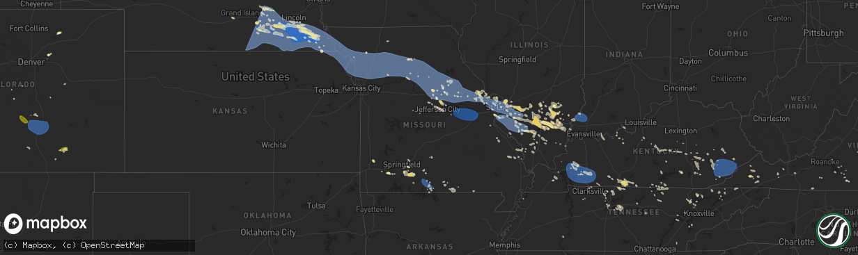
Hail Map in Missouri on July 29, 2023
The weather event in Missouri on July 29, 2023 includes Wind, Hail, and Tornado maps. 30 states and 1,258 cities were impacted and suffered possible damage. The total estimated number of properties impacted is 271.
Wind
Hail
Tornado
271
Estimated number of impacted properties by a 1.00" hail or larger0
Estimated number of impacted properties by a 1.75" hail or larger0
Estimated number of impacted properties by a 2.50" hail or largerStorm reports in Missouri
Missouri
| Date | Description |
|---|---|
| 07/29/20236:06 PM CDT | Tree down in town. |
| 07/29/20236:00 PM CDT | Healthy tree limbs down just north of aurora. |
| 07/29/20235:40 PM CDT | Large tree limbs down. Weather station just north of town measured 50mph. |
| 07/29/20234:55 PM CDT | Awos station kpcd perryville mo. |
| 07/29/20234:15 PM CDT | Lost power. Location is approximate. |
| 07/29/20234:12 PM CDT | A local report indicates 60 MPH wind near 2 E Shrewsbury |
| 07/29/20234:03 PM CDT | Area around kirkwood continued to gust around 60 mph. The area has lost power. |
| 07/29/20234:00 PM CDT | Trees and powerlines down in the cedar hill area. |
| 07/29/20234:00 PM CDT | 12 inch diameter tree down near hwy 94. 4 inch diameter branch down near hwy 94. Report from social media. Time is estimated. |
| 07/29/20233:55 PM CDT | 6 inch tree limbs down. |
| 07/29/20233:55 PM CDT | Multiple tree limbs down. One landed on a powerline. Photos submitted via social media. Time estimated by radar. |
| 07/29/20233:53 PM CDT | Roof soffit and a few shingle removed from residence. Report submitted via social media. Time estimated by radar. |
| 07/29/20233:50 PM CDT | Report submitted via social media. |
| 07/29/20233:50 PM CDT | Large branches down. |
| 07/29/20233:46 PM CDT | Large maple tree blown over at the corner of sutton and richmond in maplewood. Report accompanied by photo courtesy of kmov-tv. Time estimated by radar. |
| 07/29/20233:46 PM CDT | Large tree branch down just southwest of george winter park. Photo submitted via social media. Time estimated by radar. |
| 07/29/20233:45 PM CDT | 4-6 inch tree limbs down. Location is approximate. Estimated 50 mph wind gusts. |
| 07/29/20233:41 PM CDT | Multiple photos of tree damage at a residence near highway 270 west of kirkwood. Photos submitted on social media. Time estimated by radar. |
| 07/29/20233:40 PM CDT | Large tree branches down. |
| 07/29/20233:39 PM CDT | Multiple trees down near st. Matthews and manor hill in ofallon. Time estimated by radar. |
| 07/29/20233:37 PM CDT | Multiple tree branches down. Largest limb was about 10 inches in diameter which knocked down a residential fence. Time estimated by radar. |
| 07/29/20233:33 PM CDT | Spotter measured the gust with an anemometer installed at their residence. |
| 07/29/20233:30 PM CDT | Small tree down... Flashing torn from roof. |
| 07/29/20233:29 PM CDT | 40 ft tree down at clintonview court in st charles city. |
| 07/29/20233:29 PM CDT | St. Charles county emergency operations center reporting multiple trees and wires down across the county. Transformer fire reported near sawyer and w clay. |
| 07/29/20233:28 PM CDT | 10 inch diameter tree down on hwy p/bryan road near mexico road. Time estimated from radar. |
| 07/29/20233:28 PM CDT | Large limb down partially covering highway hh. Photos submitted via social media. Time estimated by radar. |
| 07/29/20233:25 PM CDT | 6 inch tree limbs down. A limb fell on house and caused gutter damage. |
| 07/29/20233:23 PM CDT | A local report indicates 60 MPH wind near 4 NNW Saint Peters |
| 07/29/20233:23 PM CDT | Large tree snapped at the base. Photo submitted via social media. Time estimated by radar. |
| 07/29/20233:21 PM CDT | Modot will be closing the roadway near the junction of highway b and highway c in northern st. Charles county due to multiple powerlines down in the area. Time of event |
| 07/29/20233:20 PM CDT | Several tree limbs down. Wind gusts estimated to be 60-70 mph. |
| 07/29/20233:20 PM CDT | Several tree limbs down. Wind gusts estimated to be 60-70 mph. |
| 07/29/20233:17 PM CDT | Several trees down in the area of feise road and highway k. Pictures accompanied report via social media. Time of occurrence estimated by radar. |
| 07/29/20233:16 PM CDT | Tree reported down around st. Clair. Time estimated by radar. |
| 07/29/20233:16 PM CDT | Mature tree fallen on house. 1 foot diameter tree fallen on house. Time estimate from radar. |
| 07/29/20233:15 PM CDT | Trees approx. 50 ft. Tall and 8-10 in. Diameter. Several houses lost siding in riverdale neighborhood |
| 07/29/20233:15 PM CDT | 6-8 inch tree snapped and crossroads elementary. Time estimate from radar. |
| 07/29/20233:14 PM CDT | Trees down in gasconade county. Time estimate from radar. |
| 07/29/20233:14 PM CDT | Corrects previous tstm wnd dmg report from owensville. Trees down on power lines in gasconade county. Time estimate from radar. |
| 07/29/20233:12 PM CDT | Large limb down over a residential driveway. Photos submitted via social media. Time estimated by radar. |
| 07/29/20233:12 PM CDT | Multiple limbs down off magnolia drive. Report submitted via social media with photos. Time estimated by radar. |
| 07/29/20233:07 PM CDT | Trees reported down in the union area. Time estimated by radar. |
| 07/29/20233:00 PM CDT | Power lines down. Time estimate from radar. |
| 07/29/20232:55 PM CDT | Multiple trees down south of troy. Largest limbs were 6-10 inches in diameter. Spotter recorded 53 mph gust at his personal weather station their residence in troy. |
| 07/29/20232:55 PM CDT | Shingles peeled off of roof. Picture from social media. Time estimate from radar. |
| 07/29/20232:53 PM CDT | Caller estimated winds of 65-70 mph ahead of the main line of thunderstorms. |
| 07/29/20232:53 PM CDT | 4-5 ft diameter tree fell on residence near west cherry and 4th street. Em stated that multiple areas around the county suffered tree damage. Repeater to the monroe fir |
| 07/29/20232:51 PM CDT | Local affiliate estimated gusts to be 60 mph or higher. Courtesy of ktvi-tv. |
| 07/29/20232:42 PM CDT | Tree down on bear creek bridge. Time estimate from radar. |
| 07/29/20232:41 PM CDT | Multiple areas suffered tree and powerline damage. Most extensive was along the stretch of highway 47 between warrenton and hawk point. Time estimated by radar. |
| 07/29/20232:40 PM CDT | Multiple tree damage. Time estimated from radar. |
| 07/29/20232:40 PM CDT | Corrects previous tstm wnd dmg report from bay. Trees down on power lines in gasconade county. Time estimate from radar. |
| 07/29/20232:34 PM CDT | Trees down. Time estimate from radar. |
| 07/29/20232:30 PM CDT | *** 1 inj *** emergency management reported a large tree down on an occupied vehicle. Occupant suffered injuries with emergency personnel responding to the scene. Time |
| 07/29/20232:30 PM CDT | Two powerlines down and bounced off a car... Condition of car unknown. Time estimate from radar. |
| 07/29/20232:29 PM CDT | Transformer blew. Time estimate from radar. |
| 07/29/20232:25 PM CDT | Trees down along hwy j. Time estimate from radar. |
| 07/29/20232:20 PM CDT | Trees down. Time estimate from radar. |
| 07/29/20232:20 PM CDT | Observation taken with handheld kestrel anemometer just west of middletown. Gusts of 50-60 mph continues after the initial outflow for approximately 20 minutes. |
| 07/29/20232:18 PM CDT | Time estimate from radar. 70 mph winds were persistent for 10/15 minutes. |
| 07/29/20232:08 PM CDT | Tree down across hwy 19. Time estimated by radar. |
| 07/29/20232:08 PM CDT | Fallen trees on powerlines. Time estimate from radar. |
| 07/29/20232:08 PM CDT | Fallen tree on power line. Time estimate from radar. |
| 07/29/20232:04 PM CDT | Large limbs down near santa fe. Time estimate from radar. |
| 07/29/20231:55 PM CDT | Utility line down. Time estimate from radar. |
| 07/29/20231:51 PM CDT | Multiple power outages from trees on power lines in fulton city limits. Multiple trees down in fulton city limits. Time estimate from radar. |
| 07/29/20231:51 PM CDT | Electric line down at 100 block of west street. Time estimated from radar. |
| 07/29/20231:46 PM CDT | Large tree limb down 2 miles northeast of mexico mo. Time estimated by radar. |
| 07/29/20231:44 PM CDT | Estimated gust along outflow running ahead of the main line of thunderstorms. Em relayed the report from ham radio operator. Time estimated by radar. |
| 07/29/20231:44 PM CDT | Tree limb down on powerline near south morris and west breckenridge. Time estimated by radar. |
| 07/29/20231:41 PM CDT | A local report indicates 59 MPH wind near 3 NE Ashland |
| 07/29/20231:30 PM CDT | Large trees down. |
| 07/29/20231:30 PM CDT | Trees down on a car and home. |
| 07/29/20231:30 PM CDT | Tree down on home. |
| 07/29/20231:27 PM CDT | Power pole snapped. |
| 07/29/20231:25 PM CDT | Small limbs down in the area. Multiple power outages reported. Time estimated by radar. |
| 07/29/20231:25 PM CDT | Streetlight in roadway at 600 block of heidman road. Time estimated from radar. |
| 07/29/20231:25 PM CDT | Large tree down on deck and part of house. |
| 07/29/20231:25 PM CDT | Trees down. |
| 07/29/20231:24 PM CDT | Rescue of person blown from patio hanging off the ledge at high rise apartment building. Time estimated from radar. |
| 07/29/20231:23 PM CDT | Steel roof peeled off of home. |
| 07/29/20231:20 PM CDT | A local report indicates 60 MPH wind near Green City |
| 07/29/20231:18 PM CDT | 8 inch tree limb broken. |
| 07/29/20231:17 PM CDT | Several small limbs down in the area. Spotter estimated winds to be near 60 mph. |
| 07/29/20231:17 PM CDT | Nws employee stated that winds were solidly at 60 mph. Large tree limbs down in the area. One limb down near elm street that is about 18 inches in diameter. |
| 07/29/20231:17 PM CDT | Emergency management has relayed several reports of tree and power line damage. Downed trees have blocked some roadway within the columbia city limits. |
| 07/29/20231:16 PM CDT | Power lines down near worley and providence inside city limits. Power outages and traffic lights out in town. |
| 07/29/20231:15 PM CDT | Em reporting thousands without power across boone county between 1:15 and 1:45pm. |
| 07/29/20231:10 PM CDT | Estimated wind of 60-70 mph from caseys gas station employee. |
| 07/29/202312:55 PM CDT | 60-70 mph. |
| 07/29/202312:52 PM CDT | A local report indicates 60 MPH wind near 1 N Marceline |
| 07/29/202312:52 PM CDT | Gust of 65 and multiple 8-10 inch limbs broken. |
| 07/29/202312:32 PM CDT | Tree and powerline down. |
| 07/29/202312:29 PM CDT | Sheriff office reports 60 mph winds. |
| 07/29/202312:23 PM CDT | Several reports of 60 mph. |
| 07/29/202312:20 PM CDT | 6 inch tree limb broken. |
| 07/29/202312:14 PM CDT | 60 mph wind and a few small tree limbs broken. |
| 07/29/202311:50 AM CDT | Several 1-2 inch tree limbs broken. |
| 07/29/202311:45 AM CDT | Sign blown down and 8-10 inch tree limbs broken in town. |
| 07/29/202311:39 AM CDT | A local report indicates 60 MPH wind near Breckenridge |
| 07/29/202311:36 AM CDT | 60-70 mph wind reported. |
| 07/29/202311:25 AM CDT | A local report indicates 60 MPH wind near 3 NE Pattonsburg |
| 07/29/202311:22 AM CDT | Report of trees and powerlines down in cowgill. |
| 07/29/202311:12 AM CDT | A local report indicates 60 MPH wind near Mcfall |
| 07/29/202311:01 AM CDT | A local report indicates 71 MPH wind near 1 NW Cameron |
| 07/29/202311:01 AM CDT | Estimate of 60-70 mph wind. |
| 07/29/202311:00 AM CDT | 50 to 60 mph winds. |
| 07/29/202310:55 AM CDT | A local report indicates 60 MPH wind near Osborn |
| 07/29/202310:49 AM CDT | Tree blocked road. |
| 07/29/202310:40 AM CDT | A local report indicates 72 MPH wind near 6 ENE Iatan |
| 07/29/202310:33 AM CDT | A local report indicates 65 MPH wind near 3 ESE Saint Joseph |
| 07/29/202310:33 AM CDT | Trees blocking multiple roads in st. Joseph. |
| 07/29/20239:58 AM CDT | Estimated wind gust at the dollar general in mound city. |
| 07/29/20239:57 AM CDT | Estimate of 50 to 60 mph with 1 inch limbs broken. |
| 07/28/20238:52 PM CDT | Several limbs down in thayer... Power outages throughout town. |
| 07/28/20238:27 PM CDT | A local report indicates 60 MPH wind near 2 SSW Moody |
| 07/28/20238:27 PM CDT | Trees down on 142 east of yy in howell county. |
| 07/28/20238:15 PM CDT | Report of tree across road at cloud 9 ranch on 160. |
| 07/28/20238:15 PM CDT | Per bakersfield fire department. Several trees down on o hwy... Highway 101 and smokey road. |
| 07/28/20238:05 PM CDT | Delayed report. Several trees down near highway 5 and highway w south of gainesville. |
| 07/28/20238:00 PM CDT | Eastern douglas county fire department reporting numerous trees down in the county. Tree down on highway 14 one mile east of highway ac. |
| 07/28/20237:50 PM CDT | Limbs down. Also had a 60mph estimated report with the storms. |
| 07/28/20237:38 PM CDT | Tree in the road on highway p southeast of ava. |
| 07/28/20237:30 PM CDT | Report of tree down on a highway 4-5 miles south of ava. Also several reports of estimated 60mph in the area. |
| 07/28/20237:23 PM CDT | Tree down on y-521 blocking the dirt road this is just west of ava. |
| 07/28/20237:22 PM CDT | Tree down on west highway 76 near goodhope. Also reports of limbs down in this area. |
All States Impacted by Hail Map on July 29, 2023
Cities Impacted by Hail Map on July 29, 2023
- Waterloo, IA
- Winthrop, IA
- Independence, IA
- Jesup, IA
- Dunkerton, IA
- Rowley, IA
- Fairbank, IA
- Brandon, IA
- Mount Auburn, IA
- Walker, IA
- Vinton, IA
- La Porte City, IA
- Atkins, IA
- Cedar Rapids, IA
- Center Point, IA
- Shellsburg, IA
- Quasqueton, IA
- Fairfax, IA
- Palo, IA
- Urbana, IA
- Durango, IA
- Bernard, IA
- Hopkinton, IA
- Coggon, IA
- Worthington, IA
- Central City, IA
- Robins, IA
- Delhi, IA
- Manchester, IA
- Marion, IA
- Ryan, IA
- Langworthy, IA
- Springville, IA
- Monticello, IA
- Alburnett, IA
- Farley, IA
- Dubuque, IA
- Earlville, IA
- Epworth, IA
- Peosta, IA
- Toddville, IA
- Dyersville, IA
- Anamosa, IA
- Cascade, IA
- Masonville, IA
- Prairieburg, IA
- Delaware, IA
- Hiawatha, IA
- Akron, CO
- Yuma, CO
- Joes, CO
- Cope, CO
- Tucson, AZ
- Cleveland, GA
- Clermont, GA
- Dahlonega, GA
- Murrayville, GA
- Dawsonville, GA
- Cartersville, GA
- Sutton, NE
- McCool Junction, NE
- York, NE
- Henderson, NE
- Grafton, NE
- Guide Rock, NE
- Edgar, NE
- Nelson, NE
- Superior, NE
- Bradshaw, NE
- Clay Center, NE
- Saronville, NE
- Oak, NE
- Geneva, NE
- Ong, NE
- Fairmont, NE
- Stromsburg, NE
- Benedict, NE
- Waco, NE
- Davenport, NE
- Shickley, NE
- Deshler, NE
- Ruskin, NE
- Hardy, NE
- Ohiowa, NE
- Strang, NE
- Carleton, NE
- Exeter, NE
- Bruning, NE
- Milligan, NE
- Tobias, NE
- Western, NE
- Gresham, NE
- Milford, NE
- Seward, NE
- Utica, NE
- Dorchester, NE
- Beaver Crossing, NE
- Crete, NE
- Friend, NE
- Cordova, NE
- Hebron, NE
- Belvidere, NE
- Daykin, NE
- Fairbury, NE
- Wilber, NE
- Alexandria, NE
- Swanton, NE
- Plymouth, NE
- De Witt, NE
- Jansen, NE
- Goehner, NE
- Pleasant Dale, NE
- Denton, NE
- Martell, NE
- Hallam, NE
- Cortland, NE
- Clatonia, NE
- Beatrice, NE
- Pickrell, NE
- Gilead, NE
- Steele City, NE
- Odell, NE
- Diller, NE
- Endicott, NE
- Blue Springs, NE
- Wymore, NE
- Sprague, NE
- Roca, NE
- Firth, NE
- Filley, NE
- Adams, NE
- Hickman, NE
- Bennet, NE
- Liberty, NE
- Virginia, NE
- Panama, NE
- Lincoln, NE
- Crab Orchard, NE
- Tecumseh, NE
- Douglas, NE
- Sterling, NE
- Palmyra, NE
- Burr, NE
- Unadilla, NE
- Syracuse, NE
- Cook, NE
- Elk Creek, NE
- Lewiston, NE
- Steinauer, NE
- Burchard, NE
- Talmage, NE
- Johnson, NE
- Auburn, NE
- Table Rock, NE
- Humboldt, NE
- Brock, NE
- Pawnee City, NE
- Brownville, NE
- Julian, NE
- Du Bois, NE
- Peru, NE
- Nebraska City, NE
- Dawson, NE
- Stella, NE
- Nemaha, NE
- Salem, NE
- Verdon, NE
- Shubert, NE
- Falls City, NE
- Rock Port, MO
- Fairfax, MO
- Craig, MO
- Rulo, NE
- Mound City, MO
- Forest City, MO
- Hiawatha, KS
- Sabetha, KS
- Morrill, KS
- White Cloud, KS
- Maitland, MO
- Oregon, MO
- Fillmore, MO
- Saint Joseph, MO
- Robinson, KS
- Wathena, KS
- Highland, KS
- Amazonia, MO
- Savannah, MO
- Troy, KS
- Cosby, MO
- Elwood, KS
- Barneston, NE
- Easton, MO
- Stewartsville, MO
- Agency, MO
- Clarksdale, MO
- Helena, MO
- Rosendale, MO
- Union Star, MO
- Maysville, MO
- Amity, MO
- Gower, MO
- Faucett, MO
- Denton, KS
- Bendena, KS
- Rushville, MO
- Dearborn, MO
- De Kalb, MO
- Atchison, KS
- Weston, MO
- Leavenworth, KS
- Platte City, MO
- Camden Point, MO
- Osborn, MO
- Edgerton, MO
- Winston, MO
- Smithville, MO
- Weatherby, MO
- Cameron, MO
- Trimble, MO
- Plattsburg, MO
- Lathrop, MO
- Turney, MO
- Excelsior Springs, MO
- Kearney, MO
- Holt, MO
- Liberty, MO
- Kingston, MO
- Gallatin, MO
- Hamilton, MO
- Altamont, MO
- Kidder, MO
- Polo, MO
- Lawson, MO
- Rayville, MO
- Cowgill, MO
- Richmond, MO
- Hardin, MO
- Braymer, MO
- Norborne, MO
- Breckenridge, MO
- Ludlow, MO
- Jamesport, MO
- Carrollton, MO
- Dawn, MO
- Bogard, MO
- Lock Springs, MO
- Chillicothe, MO
- Mooresville, MO
- Utica, MO
- Tina, MO
- Hale, MO
- Brunswick, MO
- Triplett, MO
- De Witt, MO
- Bosworth, MO
- Sumner, MO
- Slater, MO
- Dalton, MO
- Miami, MO
- Meadville, MO
- Wheeling, MO
- Mendon, MO
- Salisbury, MO
- Keytesville, MO
- Glasgow, MO
- Chula, MO
- Brookfield, MO
- Rothville, MO
- Laclede, MO
- Marceline, MO
- Linneus, MO
- New Cambria, MO
- Bucklin, MO
- Armstrong, MO
- Fayette, MO
- Clifton Hill, MO
- Callao, MO
- Huntsville, MO
- Bevier, MO
- Excello, MO
- Higbee, MO
- Rocheport, MO
- Columbia, MO
- Harrisburg, MO
- Macon, MO
- Sturgeon, MO
- Moberly, MO
- Cairo, MO
- Clark, MO
- Ashland, MO
- Hallsville, MO
- Centralia, MO
- Jacksonville, MO
- Madison, MO
- Holliday, MO
- Freedom, NH
- Madison, NH
- Brownfield, ME
- Porter, ME
- Ashley, IL
- Mount Vernon, IL
- Dix, IL
- Marissa, IL
- Saint Libory, IL
- Mascoutah, IL
- Ewing, IL
- Belle Rive, IL
- Ina, IL
- Carmi, IL
- Enfield, IL
- Nashville, IL
- Hoyleton, IL
- Waltonville, IL
- Woodlawn, IL
- Whigham, GA
- Cairo, GA
- McLeansboro, IL
- Pelham, GA
- Bonnie, IL
- Du Bois, IL
- Dahlgren, IL
- Springerton, IL
- New Harmony, IN
- Hartville, MO
- Bradfordsville, KY
- Gravel Switch, KY
- Macedonia, IL
- Opdyke, IL
- Carrier Mills, IL
- Marion, IL
- Lenzburg, IL
- Addieville, IL
- Keenes, IL
- Polk, NE
- Centralia, IL
- Scheller, IL
- Walnut Hill, IL
- Okawville, IL
- Oakdale, IL
- Whittington, IL
- Wayne City, IL
- Fulton, MO
- Thompson, MO
- Paris, MO
- Rush Hill, MO
- Mexico, MO
- Kingdom City, MO
- Auxvasse, MO
- Perry, MO
- Santa Fe, MO
- Laddonia, MO
- Benton City, MO
- Goffstown, NH
- Manchester, NH
- Farber, MO
- Vandalia, MO
- Martinsburg, MO
- Williamsburg, MO
- Montgomery City, MO
- Steedman, MO
- Wellsville, MO
- Portland, MO
- Rhineland, MO
- New Florence, MO
- Middletown, MO
- Warrenton, MO
- Truxton, MO
- Jonesburg, MO
- Bellflower, MO
- High Hill, MO
- Hermann, MO
- Hawk Point, MO
- Troy, MO
- Wright City, MO
- Silex, MO
- Moscow Mills, MO
- Truesdale, MO
- Foristell, MO
- Busy, KY
- Bulan, KY
- Hyden, KY
- Hazard, KY
- Bonnyman, KY
- Wooton, KY
- Krypton, KY
- Hindman, KY
- Combs, KY
- Carrie, KY
- Delphia, KY
- Smilax, KY
- Linefork, KY
- Viper, KY
- Partridge, KY
- Cornettsville, KY
- Slemp, KY
- Happy, KY
- Neon, KY
- Deane, KY
- Seco, KY
- Vicco, KY
- Sassafras, KY
- Whitesburg, KY
- Letcher, KY
- Jenkins, KY
- Jeff, KY
- Millstone, KY
- Thornton, KY
- Yeaddiss, KY
- Eolia, KY
- Ermine, KY
- Jeremiah, KY
- Mayking, KY
- Benham, KY
- Premium, KY
- Pine Top, KY
- Mallie, KY
- Redfox, KY
- Scuddy, KY
- Cumberland, KY
- Lynch, KY
- Hallie, KY
- Blackey, KY
- Gordon, KY
- Roxana, KY
- Littcarr, KY
- Isom, KY
- Helton, KY
- Wendover, KY
- Evarts, KY
- Stinnett, KY
- Putney, KY
- Chappell, KY
- Baxter, KY
- Mozelle, KY
- Bledsoe, KY
- Big Laurel, KY
- Essie, KY
- Warbranch, KY
- Totz, KY
- Dwarf, KY
- Emmalena, KY
- Morrison, MO
- Bland, MO
- Mount Sterling, MO
- Owensville, MO
- Gerald, MO
- Washington, MO
- Leslie, MO
- Rosebud, MO
- Berger, MO
- New Haven, MO
- Union, MO
- Beaufort, MO
- Clarence, MO
- Boyds, MD
- Clarksburg, MD
- Damascus, MD
- Gaithersburg, MD
- Germantown, MD
- Mount Airy, MD
- Dickerson, MD
- Barnesville, MD
- Sullivan, MO
- Villa Ridge, MO
- Saint Clair, MO
- Saint Peters, MO
- Saint Charles, MO
- O'Fallon, MO
- Wentzville, MO
- Lake Saint Louis, MO
- Old Monroe, MO
- Maryland Heights, MO
- Saint Louis, MO
- Glen Echo, MD
- Potomac, MD
- Cabin John, MD
- Bethesda, MD
- Washington, DC
- Chevy Chase, MD
- Earth City, MO
- Hazelwood, MO
- Bridgeton, MO
- Florissant, MO
- Chesterfield, MO
- Saint Ann, MO
- Alexandria, VA
- Falls Church, VA
- Arlington, VA
- Annandale, VA
- McLean, VA
- Capitol Heights, MD
- Oxon Hill, MD
- Clinton, MD
- Suitland, MD
- Andrews Air Force Base, MD
- Upper Marlboro, MD
- Fort Washington, MD
- Temple Hills, MD
- District Heights, MD
- Naval Anacost Annex, DC
- Bowie, MD
- Annapolis, MD
- Edgewater, MD
- Gambrills, MD
- Odenton, MD
- Crownsville, MD
- Crofton, MD
- Davidsonville, MD
- Riva, MD
- Shady Side, MD
- Galesville, MD
- West River, MD
- Harwood, MD
- Fort Myer, VA
- Ballwin, MO
- East Saint Louis, IL
- Lovejoy, IL
- Madison, IL
- East Carondelet, IL
- Granite City, IL
- Venice, IL
- Fairview Heights, IL
- Lebanon, IL
- Belleville, IL
- O'Fallon, IL
- Troy, IL
- Dupo, IL
- Collinsville, IL
- Caseyville, IL
- Millstadt, IL
- Freeburg, IL
- Scott Air Force Base, IL
- Waterloo, IL
- Valmeyer, IL
- Columbia, IL
- Smithton, IL
- New Athens, IL
- Red Bud, IL
- Hecker, IL
- Flora, IL
- Clay City, IL
- Chestertown, MD
- Worton, MD
- Millington, MD
- Still Pond, MD
- Kennedyville, MD
- Stevensville, MD
- Claiborne, MD
- Mcdaniel, MD
- Wittman, MD
- Saint Michaels, MD
- Bozman, MD
- Sherwood, MD
- Royal Oak, MD
- Neavitt, MD
- New Baden, IL
- Trenton, IL
- Albers, IL
- Bartelso, IL
- Waynesville, NC
- Model, CO
- Aurora, MO
- Marionville, MO
- Galena, MD
- Massey, MD
- Clayton, DE
- Townsend, DE
- Crumpton, MD
- Chester, IL
- Walsh, IL
- Coulterville, IL
- Pinckneyville, IL
- Ellis Grove, IL
- Evansville, IL
- Steeleville, IL
- Du Quoin, IL
- Percy, IL
- Sparta, IL
- Tilden, IL
- Tamaroa, IL
- Cutler, IL
- Baldwin, IL
- Rehoboth Beach, DE
- Brooklyn, CT
- Marine, IL
- Edwardsville, IL
- Saint Jacob, IL
- Brussels, IL
- Golden Eagle, IL
- Sainte Genevieve, MO
- Fairfield, IL
- Girdler, KY
- Hinkle, KY
- Cannon, KY
- Barbourville, KY
- Rogersville, MO
- Albany, KY
- Byrdstown, TN
- Clanton, AL
- Jemison, AL
- Nokesville, VA
- Gainesville, VA
- Bristow, VA
- Bedford, NH
- New Bloomfield, MO
- Ashburn, VA
- Leesburg, VA
- Farmington, MO
- Forest, MS
- Allensville, KY
- Ceres, VA
- Glen Arm, MD
- Abingdon, MD
- Hydes, MD
- Phoenix, MD
- Kingsville, MD
- Gunpowder, MD
- Edgewood, MD
- Joppa, MD
- Nottingham, MD
- White Marsh, MD
- Upper Falls, MD
- Fallston, MD
- Fork, MD
- Baldwin, MD
- Perry Hall, MD
- Eidson, TN
- Rogersville, TN
- Sneedville, TN
- Pelahatchie, MS
- Pall Mall, TN
- Ten Mile, TN
- Kingston, TN
- Rockwood, TN
- Booneville, KY
- Ricetown, KY
- McKee, KY
- Port Tobacco, MD
- La Plata, MD
- Jackson, KY
- Carterville, IL
- Bluford, IL
- Iuka, IL
- Salem, IL
- Dante, VA
- Bee, VA
- Cleveland, VA
- Monticello, KY
- Springfield, TN
- Greenbrier, TN
- Vest, KY
- Rocky Top, TN
- Jacksboro, TN
- Caryville, TN
- Morton, MS
- Brandon, MS
- Cottontown, TN
- Cross Plains, TN
- New Tazewell, TN
- Sharps Chapel, TN
- Speedwell, TN
- Tebbetts, MO
- Bonnots Mill, MO
- Jefferson City, MO
- Hartsburg, MO
- Holts Summit, MO
- La Vergne, TN
- Mount Juliet, TN
- Lebanon, TN
- Hermitage, TN
- Crawford, TN
- Allred, TN
- Rickman, TN
- Grand Tower, IL
- Wolf Lake, IL
- Carlyle, IL
- Jackson, MO
- Portland, TN
- Westmoreland, TN
- Bethpage, TN
- Mulkeytown, IL
- Spickard, MO
- Kingman, AZ
- Hackberry, AZ
- La Follette, TN
- Scottsville, KY
- Adolphus, KY
- Duffield, VA
- Goodlettsville, TN
- Joelton, TN
- Whites Creek, TN
- Cape Girardeau, MO
- Mokane, MO
- Winfield, MO
- Castlewood, VA
- Lebanon, VA
- Somerset, KY
- Burnside, KY
- Millersville, MO
- Marble Hill, MO
- Thorsby, AL
- Saint Paul, VA
- Kyles Ford, TN
- Springfield, KY
- Lebanon, KY
- Johnston City, IL
- West Frankfort, IL
- Thompsonville, IL
- Pittsburg, IL
- Magee, MS
- Mendenhall, MS
- Alto Pass, IL
- Jakin, GA
- Donalsonville, GA
- Annville, KY
- Tyner, KY
- Knoxville, TN
- Heiskell, TN
- Arnold, MO
- Gray, KY
- Lake, MS
- Andersonville, TN
- Maynardville, TN
- Liberty, KY
- Pinola, MS
- Stanford, KY
- Crab Orchard, KY
- Birchleaf, VA
- Clinchco, VA
- Haysi, VA
- Glen Carbon, IL
- Verona, MO
- Christopher, IL
- Sesser, IL
- Benton, IL
- Royalton, IL
- Jamestown, TN
- Altenburg, MO
- Pulaski, MS
- Nashville, TN
- Bowman, ND
- Irvine, KY
- Alma, IL
- Laurel, MD
- Richmond, KY
- Atkins, VA
- Auburn, KY
- Jamestown, MO
- Centertown, MO
- Raton, NM
- Woodburn, KY
- Bowling Green, KY
- Johnsonville, IL
- Carbondale, IL
- Newark, DE
- Woodstown, NJ
- Bear, DE
- New Castle, DE
- Pennsville, NJ
- Salem, NJ
- Xenia, IL
- Hendersonville, TN
- White House, TN
- Lily, KY
- London, KY
- Corbin, KY
- Burkesville, KY
- Tompkinsville, KY
- Columbiana, AL
- Shelby, AL
- Versailles, MO
- Walsenburg, CO
- Lorton, VA
- Fort Belvoir, VA
- Crane, MO
- Springfield, VA
- Elkville, IL
- Parksville, KY
- White Plains, MD
- Waldorf, MD
- Max Meadows, VA
- Draper, VA
- Harriman, TN
- Nicholasville, KY
- Russellville, TN
- Whitesburg, TN
- Accokeek, MD
- Batchtown, IL
- Foley, MO
- Harrogate, TN
- Tazewell, TN
- Breese, IL
- Aviston, IL
- Germantown, IL
- Livingston, TN
- Mooresburg, TN
- Maryville, IL
- West Blocton, AL
- Alvaton, KY
- Fountain Run, KY
- Franklin, KY
- Billings, MO
- Manchester, KY
- Hiram, ME
- Sedalia, CO
- Ashford, AL
- Thaxton, VA
- Geff, IL
- Rinard, IL
- Cisne, IL
- Sims, IL
- Hilham, TN
- Allons, TN
- Ava, IL
- Campbell Hill, IL
- Burfordville, MO
- Fairfax, VA
- Bryans Road, MD
- Vienna, VA
- Clifton, VA
- Great Falls, VA
- Burke, VA
- Dunn Loring, VA
- Woodbridge, VA
- Fairfax Station, VA
- Indian Head, MD
- Weogufka, AL
- Phenix City, AL
- Mountain Grove, MO
- Stuart, VA
- Galatia, IL
- Carthage, MO
- Jasper, MO
- Golden City, MO
- Surgoinsville, TN
- Gate City, VA
- Church Hill, TN
- Abingdon, VA
- Junction City, KY
- Kite, KY
- Topmost, KY
- Greenback, TN
- Maryville, TN
- Herrin, IL
- Energy, IL
- Windsor, KY
- Philadelphia, TN
- Wallins Creek, KY
- Harlan, KY
- Gordon, AL
- Jamestown, KY
- Russell Springs, KY
- Barnhill, IL
- Bristol, VA
- Sextons Creek, KY
- Clarksville, TN
- Mount Airy, NC
- West Alton, MO
- Monroe, TN
- Buckhorn, KY
- Sizerock, KY
- Thousandsticks, KY
- Bear Branch, KY
- Oneida, KY
- Glade Valley, NC
- Gamaliel, KY
- Freistatt, MO
- Mill Shoals, IL
- Crossville, IL
- Burnt Prairie, IL
- Norwood, MO
- Ava, MO
- Anna, IL
- Lake George, CO
- Festus, MO
- Mount Vernon, KY
- Berea, KY
- Sentinel Butte, ND
- Beach, ND
- Fairfield, ND
- Ludlow, SD
- East Bridgewater, MA
- Brockton, MA
- South Easton, MA
- West Bridgewater, MA
- Sand Coulee, MT
- Belt, MT
- Great Falls, MT
- Mount Carmel, IL
- Patoka, IN
- Owensville, IN
- Hazleton, IN
- Princeton, IN
- Francisco, IN
- Decker, IN
- Fort Branch, IN
- Fredonia, KY
- Princeton, KY
- Dawson Springs, KY
- Gainesville, MO
- Brixey, MO
- Squires, MO
- Noble, MO
- Zanoni, MO
- Wasola, MO
- Thornfield, MO
- Hardenville, MO
- Crofton, KY
- Saint Charles, KY
- White Plains, KY
- Cerulean, KY
- Hopkinsville, KY
- Rockvale, CO
- Canon City, CO
- Wetmore, CO
- Florence, CO
- Orchard, CO
- Grassy Butte, ND
- Killdeer, ND
- Dunn Center, ND
- Medora, ND
- Belfield, ND
- New England, ND
- Amidon, ND
- Rhame, ND
- Geyser, MT
- Geraldine, MT
- Highwood, MT
- Elkton, KY
- Pembroke, KY
- Eddyville, KY
- Herndon, KY
- Trenton, KY
- Cadiz, KY
- Oak Grove, KY
- Gracey, KY
- Solomons, MD
- Lexington Park, MD
- Great Mills, MD
- Callaway, MD
- California, MD
- Patuxent River, MD
- Saint Inigoes, MD
- Drayden, MD
- Ridge, MD
- Dameron, MD
- Valley Lee, MD
- Scotland, MD
- Park Hall, MD
- Lusby, MD
- Bennett, CO
- Halliday, ND
- Scranton, ND
- Reva, SD
- Prairie City, SD
- Mud Butte, SD
- Faith, SD
- Buffalo, SD
- Newell, SD
- Enning, SD
- Union Center, SD
- White Owl, SD
- Moccasin, MT
- Moore, MT
- Lewistown, MT
- Hobson, MT
- Grass Range, MT
- Wall, SD
- Howes, SD
- Wasta, SD
- Forest Grove, MT
- Winnett, MT
- Quinn, SD
- Philip, SD
- Colorado City, CO
- Penrose, CO
- Pueblo, CO
- Beulah, CO
- Rye, CO
- Avondale, CO
- Walnut Ridge, AR
- Beech Grove, AR
- Bono, AR
- Ararat, NC
- Dobson, NC
- Oak Ridge, TN
- Union Star, KY
- Lynch Station, VA
- Irvington, KY
- Pamplin, VA
- Appomattox, VA
- Marion, NC
- Denton, MT
- Statesville, NC
- Marietta, SC
- Cleveland, SC
- Cumberland Furnace, TN
- Cumberland City, TN
- Vanleer, TN
- Boston, KY
- Lebanon Junction, KY
- Shepherdsville, KY
- Dillwyn, VA
- Fordland, MO
- Bruner, MO
- Lucedale, MS
- Thayer, MO
- Mammoth Spring, AR
- Koshkonong, MO
- Sonoita, AZ
- Vail, AZ
- Rousseau, KY
- Springfield, MO
- West Plains, MO
- Hurt, VA
- Penhook, VA
- Union Hall, VA
- Sandy Level, VA
- Caret, VA
- Guffey, CO
- Buena Vista, GA
- Americus, GA
- Plains, GA
- Shellman, GA
- Ellaville, GA
- Chestnut Mound, TN
- Elmwood, TN
- Georgetown, DE
- Elberfeld, IN
- Lynnville, IN
- Oakland City, IN
- Chatham, VA
- Keeling, VA
- Sparta, MO
- Ozark, MO
- Chadwick, MO
- Oldfield, MO
- Sturgis, KY
- Norris, TN
- Gretna, VA
- Elkin, NC
- Columbia, AL
- Headland, AL
- Webb, AL
- East Bend, NC
- Higden, AR
- Bridgeville, DE
- Seaford, DE
- Edgemont, AR
- Shirley, AR
- Hustle, VA
- Port Royal, VA
- Dale, IN
- Lancaster, KY
- Batesville, AR
- Marcella, AR
- Locust Grove, AR
- Kinmundy, IL
- Ferrum, VA
- Mountain Home, AR
- Lynchburg, MO
- Monett, MO
- Mount Vernon, MO
- Camden, MS
- Williamsburg, KY
- Doniphan, MO
- Gatewood, MO
- Preston, GA
- Richland, GA
- Weston, GA
- Graff, MO
- Boonville, NC
- Dewey, AZ
- Prescott Valley, AZ
- Reliance, TN
- Aurora, NE
- Tiptonville, TN
- Ridgely, TN
- Bryantown, MD
- Equality, IL
- Harrisburg, IL
- Kell, IL
- Junction, IL
- Louisville, IL
- Noble, IL
- Honaker, VA
- Chandler, IN
- Evansville, IN
- Calvert City, KY
- Mistletoe, KY
- Buckingham, VA
- Scottsville, VA
- Howardsville, VA
- Salem, KY
- Siloam, NC
- Irvington, IL
- Richview, IL
- Harned, KY
- Garfield, KY
- Vernon Hill, VA
- Java, VA
- Pocahontas, AR
- Golden Gate, IL
- Occoquan, VA
- Pomfret, MD
- Philpot, KY
- Grandview, IN
- Lewisport, KY
- Maceo, KY
- Opelika, AL
- Salem, AL
- Pippa Passes, KY
- Bone Gap, IL
- Albion, IL
- Texico, IL
- Seale, AL
- Warsaw, VA
- Hardinsburg, KY
- Webster, KY
- Thurmond, NC
- Roaring Gap, NC
- Haubstadt, IN
- Oakman, AL
- Sparta, TN
- Mayfield, KY
- Stearns, KY
- Pinnacle, NC
- Millsboro, DE
- Showell, MD
- Frankford, DE
- Delmar, DE
- Whaleyville, MD
- Willards, MD
- Laurel, DE
- Bishopville, MD
- Berlin, MD
- Loretto, KY
- Altha, FL
- Fountain, FL
- Canton, MS
- Dawson, GA
- State Road, NC
- Cynthiana, IN
- Stephensport, KY
- Marbury, MD
- Bunnell, FL
- Antioch, TN
- Mauckport, IN
- Central, IN
- Battletown, KY
- Columbus, NC
- Mill Spring, NC
- Cartersville, VA
- Cumberland, VA
- Powhatan, VA
- Buncombe, IL
- Gladstone, VA
- Bradleyville, MO
- Garrison, MO
- Sandgap, KY
- Nixa, MO
- Denton, MD
- Lake City, AR
- Woodford, VA
- Spotsylvania, VA
- Fredericksburg, VA
- Ellery, IL
- Henry, VA
- East Flat Rock, NC
- Flat Rock, NC
- Hendersonville, NC
- Bowersville, GA
- Hartwell, GA
- Mountain View, AR
- Benton, KY
- Symsonia, KY
- Huddleston, VA
- Kadoka, SD
- Ingomar, MT
- Carthage, TN
- Winifred, MT
- Berthold, ND
- Des Lacs, ND
- Matheson, CO
- Reeder, ND
- Cunningham, TN
- Stanley, ND
- Calhan, CO
- Tecumseh, MO
- Zahl, ND
- Seymour, MO
- Plaza, ND
- Grenora, ND
- Long Valley, SD
- Fairburn, GA
- White River, SD
- Palermo, ND
- Cobden, IL
- Makanda, IL
- Clarkridge, AR
- Corydon, IN
- Decatur, GA
- Ellenwood, GA
- Mansfield, MO
- Browns, IL
- Ross, ND
- Wilder, TN
- Macon, GA
- Wanblee, SD
- Oak Ridge, MO
- Atlanta, GA
- Smyrna, GA
- Marietta, GA
- Parshall, ND
- Garrison, ND
- Roseglen, ND
- Clinton, TN
- Marshfield, MO
- Strafford, MO
- Naylor, MO
- Hinsdale, MT
- Richland, MT
- Opheim, MT
- Peerless, MT
- Larslan, MT
- Glentana, MT
- Scobey, MT
- Wolf Point, MT
- Frazer, MT
- Poplar, MT
- Brockton, MT
- Flaxville, MT
- Homestead, MT
- Medicine Lake, MT
- Froid, MT
- Richardton, ND
- Hebron, ND
- New Leipzig, ND
- Glen Ullin, ND
- Elgin, ND
- Carson, ND
- Dagmar, MT
- Antelope, MT
- Reserve, MT
- Musselshell, MT
- Wood River, NE
- Williston, ND
- Bainville, MT
- Westby, MT
- Benton, TN
- Vonore, TN
- Savannah, TN
- Prim, AR
- Almont, ND
- New Salem, ND
- Taylor, ND
- Flasher, ND


