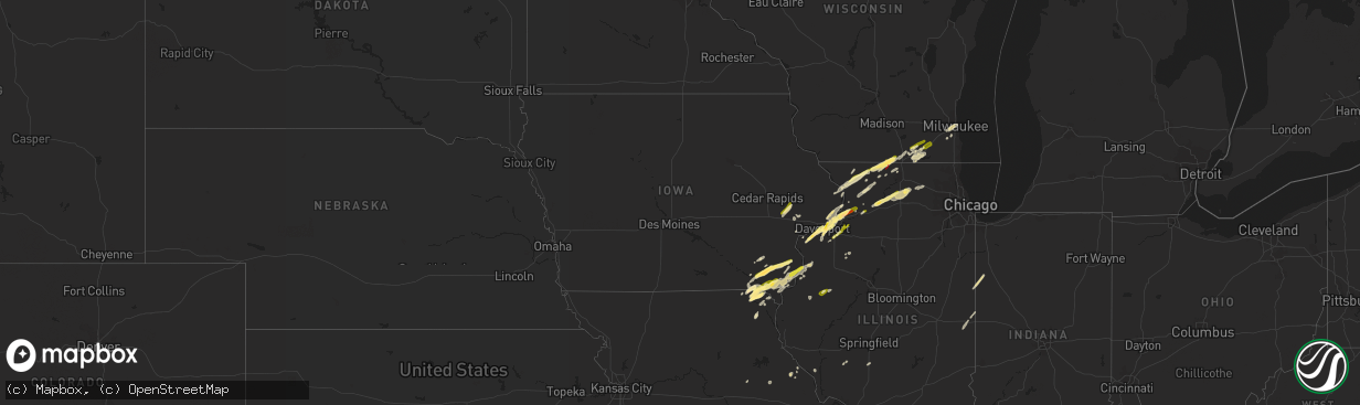
Hail Map in Iowa on March 4, 2024
The weather event in Iowa on March 4, 2024 includes Hail, Wind, and Tornado maps. 9 states and 455 cities were impacted and suffered possible damage. The total estimated number of properties impacted is 26,718.
Hail
Wind
Tornado
26,718
Estimated number of impacted properties by a 1.00" hail or larger402
Estimated number of impacted properties by a 1.75" hail or larger0
Estimated number of impacted properties by a 2.50" hail or largerStorm reports in Iowa
Iowa
| Date | Description |
|---|---|
| 03/04/20245:43 PM CST | Reported at caseys. |
| 03/04/20245:37 PM CST | A local report indicates 1.00 inch wind near 1 E West Burlington |
| 03/04/20244:18 PM CST | Delayed report... Lasted 5-10 min with 30 mph winds. Time estimated from radar. |
| 03/04/20244:00 PM CST | Quarter hail at i-280 and highway 61. |
| 03/04/20243:35 PM CST | Delayed report via social media picture. |
| 03/04/20242:53 PM CST | Nickel to quarter sized hail. |
| 03/04/20242:51 PM CST | A local report indicates 1.00 inch wind near 1 NE Bettendorf |
| 03/04/20242:51 PM CST | A local report indicates 1.00 inch wind near 2 WSW Bettendorf |
| 03/04/20242:50 PM CST | Dime to quarter size hail. |
| 03/04/20242:50 PM CST | Numerous small stones but a few stones to ping pong ball size. Time estimated using radar. |
| 03/04/20242:50 PM CST | Via social media picture. |
| 03/04/20242:49 PM CST | Dime to quarter size hail. |
| 03/03/20248:34 PM CST | A local report indicates 1.00 inch wind near 4 NE Cedar Bluff |
| 03/03/20247:18 PM CST | Largest stones were quarter size. Picture from social media. |
All States Impacted by Hail Map on March 4, 2024
Cities Impacted by Hail Map on March 4, 2024
- Port Sulphur, LA
- Pollock, LA
- Georgetown, LA
- Mount Carroll, IL
- Elizabeth, IL
- Stockton, IL
- Pearl City, IL
- Monroe, LA
- Lena, IL
- Freeport, IL
- Cedarville, IL
- Dakota, IL
- Strong, AR
- Huttig, AR
- Rock City, IL
- Davis, IL
- Durand, IL
- Hermitage, AR
- Bettendorf, IA
- Brodhead, WI
- Beloit, WI
- Sterlington, LA
- Bastrop, LA
- Jersey, AR
- Banks, AR
- Warren, AR
- Orion, IL
- Osco, IL
- Geneseo, IL
- Trout, LA
- Tullos, LA
- Olla, LA
- Prophetstown, IL
- Kelly, LA
- Grayson, LA
- Columbia, LA
- Taylor Ridge, IL
- Illinois City, IL
- Reynolds, IL
- Keosauqua, IA
- Stockport, IA
- Hillsboro, IA
- Salem, IA
- Mount Pleasant, IA
- Bernice, LA
- Andalusia, IL
- Spearsville, LA
- Milan, IL
- Arbela, MO
- Luray, MO
- Mount Sterling, IA
- Farmington, IA
- Bonaparte, IA
- Kahoka, MO
- Donnellson, IA
- Lillie, LA
- Buffalo, IA
- Blue Grass, IA
- Davenport, IA
- New London, IA
- Rock Island, IL
- West Point, IA
- Moline, IL
- East Moline, IL
- Le Claire, IA
- Port Byron, IL
- Cordova, IL
- Hillsdale, IL
- Albany, IL
- Erie, IL
- Fulton, IL
- Fenton, IL
- Pickens, AR
- Whitewater, WI
- Avalon, WI
- Delavan, WI
- Tillar, AR
- Elkhorn, WI
- East Troy, WI
- Morrison, IL
- Dumas, AR
- Hampton, AR
- Louann, AR
- Princeton, IA
- Sherrard, IL
- Lynn Center, IL
- Shannon, IL
- Silvis, IL
- El Dorado, AR
- Marrero, LA
- Milledgeville, IL
- Lanark, IL
- Forreston, IL
- Chadwick, IL
- Bonita, LA
- Jones, LA
- Hamburg, AR
- Montrose, AR
- Rockton, IL
- Lake Village, AR
- Collinston, LA
- Pecatonica, IL
- Dermott, AR
- Lafitte, LA
- Braithwaite, LA
- Savanna, IL
- Sabula, IA
- Long Grove, IA
- Camanche, IA
- Eldridge, IA
- Chatham, LA
- La Place, LA
- Coal Valley, IL
- Pleasant Valley, IA
- Janesville, WI
- Miles, IA
- Lettsworth, LA
- Simmesport, LA
- Moreauville, LA
- Farmerville, LA
- West Monroe, LA
- Marion, LA
- Oak Ridge, LA
- Jonesville, LA
- Pineville, LA
- Dry Prong, LA
- Clinton, IA
- Hampton, IL
- Carbon Cliff, IL
- Athens, LA
- Dubberly, LA
- Rapids City, IL
- Yarmouth, IA
- Mount Union, IA
- Morning Sun, IA
- Mediapolis, IA
- Dixon, IL
- Oregon, IL
- Pine Bluff, AR
- Grady, AR
- Altheimer, AR
- Sterling, IL
- Rock Falls, IL
- Burlington, WI
- Meraux, LA
- Violet, LA
- New Orleans, LA
- Gillett, AR
- Chana, IL
- Ashton, IL
- Franklin Grove, IL
- Rochelle, IL
- Davis Junction, IL
- Holcomb, IL
- West Burlington, IA
- Burlington, IA
- De Witt, AR
- Humphrey, AR
- Wabbaseka, AR
- Humnoke, AR
- Esmond, IL
- Kirkland, IL
- Poplar Bluff, MO
- Harrisburg, AR
- Trumann, AR
- Bay, AR
- Jonesboro, AR
- Bushnell, IL
- Good Hope, IL
- Prairie City, IL
- Macomb, IL
- Iowa City, IA
- West Branch, IA
- Solon, IA
- Tipton, IA
- Mechanicsville, IA
- Rockford, IL
- Harrell, AR
- Saint Patrick, MO
- Carlisle, AR
- Darien, WI
- Machesney Park, IL
- Sharon, WI
- Zalma, MO
- Sturdivant, MO
- Batesville, AR
- Cave City, AR
- Ridott, IL
- Franklin, WI
- Genoa, IL
- Hampshire, IL
- Winnebago, IL
- Wever, IA
- Fort Madison, IA
- Denmark, IA
- Bloomfield, MO
- Puxico, MO
- Dudley, MO
- Cantril, IA
- Carthage, AR
- Searcy, AR
- Junction City, AR
- Malta, IL
- Lindenwood, IL
- Monroe Center, IL
- Clare, IL
- Kingston, IL
- Beebe, AR
- Wheatley, AR
- Brinkley, AR
- Cotton Plant, AR
- Muskego, WI
- Montrose, IA
- England, AR
- Bluffton, TX
- Buchanan Dam, TX
- Clarendon, AR
- Bennett, IA
- Casscoe, AR
- Holly Grove, AR
- Stuttgart, AR
- Roe, AR
- Goodwin, AR
- Moro, AR
- Hazen, AR
- Gladstone, IL
- Danville, IA
- Middletown, IA
- Memphis, MO
- Oquawka, IL
- Little York, IL
- Monmouth, IL
- Carman, IL
- Seaton, IL
- Sperry, IA
- Milwaukee, WI
- Clinton, WI
- Williams Bay, WI
- Walworth, WI
- Capron, IL
- Lake Geneva, WI
- Stronghurst, IL
- Baileyville, IL
- German Valley, IL
- Birmingham, IA
- Gould, AR
- Cherry Valley, AR
- Leola, AR
- Saint Bernard, LA
- Oil Trough, AR
- Clinton, AR
- Watson, AR
- Winchester, AR
- Marked Tree, AR
- Moscow, IA
- Atalissa, IA
- Muscatine, IA
- Wynne, AR
- Parkin, AR
- Forrest City, AR
- Widener, AR
- Weiner, AR
- Brookland, AR
- Heth, AR
- Magnolia, AR
- Emerson, AR
- McRae, AR
- Wayland, MO
- New Berlin, WI
- Paragould, AR
- Sparkman, AR
- Joy, IL
- Hales Corners, WI
- Newport, AR
- Tichnor, AR
- Crocketts Bluff, AR
- Lockridge, IA
- Graff, MO
- Cabool, MO
- Hico, TX
- Iredell, TX
- Marble Hill, MO
- Nashville, AR
- Dierks, AR
- Ava, MO
- Hermitage, MO
- Preston, MO
- Laddonia, MO
- Witts Springs, AR
- Glenallen, MO
- Louisiana, MO
- Bowling Green, MO
- Waynesville, MO
- Saint Robert, MO
- Fort Leonard Wood, MO
- Fairfield, IA
- Brighton, IA
- Mount Judea, AR
- Neelyville, MO
- Scotland, AR
- Avon, IL
- La Belle, MO
- Mountain Grove, MO
- Patton, MO
- Murfreesboro, AR
- Kirby, AR
- Stanwood, IA
- Nebo, IL
- Colchester, IL
- Galva, IL
- Amity, AR
- Altona, IL
- Langley, AR
- Delight, AR
- Newhope, AR
- Glenwood, AR
- Umpire, AR
- Centralia, MO
- Victoria, IL
- Deer, AR
- Marshall, AR
- Buras, LA
- Powell, TX
- Corsicana, TX
- Kerens, TX
- Trinidad, TX
- Malakoff, TX
- Athens, TX
- Mabank, TX
- Eustace, TX
- Palestine, TX
- Frankston, TX
- Larue, TX
- Chandler, TX
- Flint, TX
- Bullard, TX
- Tyler, TX
- Farmersville, IL
- Chester, AR
- Cedarville, AR
- Rudy, AR
- Camdenton, MO
- Milford, IL
- Earl Park, IN
- Coushatta, LA
- Hemphill, TX
- Kaufman, TX
- Wills Point, TX
- Grapeland, TX
- Jacksonville, TX
- Oakwood, TX
- Buffalo, TX
- Stoutland, MO
- Mansfield, LA
- Shirley, AR
- Richland, MO
- Leslie, AR
- Tilly, AR
- Carthage, TX
- Terrell, TX
- Montreal, MO
- Saint Elizabeth, MO
- Iberia, MO
- Tuscumbia, MO
- Grand Cane, LA
- Logansport, LA
- Quinlan, TX
- Greenville, TX
- Lone Oak, TX
- Hector, AR
- Dennard, AR
- Jerusalem, AR
- Pelsor, AR
- Hagarville, AR
- Alto, TX
- Kentland, IN
- Lewisville, AR
- Taylor, AR
- Chireno, TX
- Huntington, TX
- Etoile, TX
- Linn Creek, MO
- Mountainburg, AR
- Ozark, AR
- Van Buren, AR
- Center, TX
- Jessieville, AR
- Hot Springs Village, AR
- Springhill, LA
- Arp, TX
- Troup, TX
- Henderson, TX
- Overton, TX
- Uniontown, AR
- Natural Dam, AR
- Russellville, MO
- Pettigrew, AR
- Rice, TX
- Shreveport, LA
- Middletown, MO
- Bismarck, IL
- West Lebanon, IN
- Bronson, TX
- Danville, IL
- Fairmount, IL
- Catlin, IL
- Alma, IL
- Osage Beach, MO
- Kaiser, MO
- Groveton, TX
- Tuskahoma, OK
- San Augustine, TX
- Crockett, TX
- Pittsburg, TX
- Muldrow, OK
- Roodhouse, IL
- Palmyra, IL
- Florien, LA
- Crocker, MO
- Ringgold, LA
- Tunas, MO
- Urbana, MO
- Clarksville, AR
- Hartman, AR
- Cookson, OK
- Bradley, AR
- Lufkin, TX
- Paris, AR
- Modesto, IL
- Lebanon, MO
- Arkadelphia, AR
- Winslow, AR
- Many, LA
- Dodson, LA
- Park Hill, OK
- Vian, OK
- Brumley, MO
- Whitehouse, TX
- Streetman, TX
- Fairfield, TX
- Campbell, TX
- Selman City, TX
- Sulphur Springs, TX
- Lake Ozark, MO
- Sunrise Beach, MO
- Tennessee Colony, TX
- Eldridge, MO
- Rusk, TX
- Point, TX
- Como, TX
- Macks Creek, MO
- Roach, MO
- Roland, OK
- Bryant, IA
- Goodland, IN


