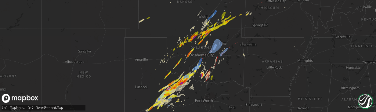
Hail Map in Oklahoma on April 27, 2024
The weather event in Oklahoma on April 27, 2024 includes Hail, Wind, and Tornado maps. 11 states and 783 cities were impacted and suffered possible damage. The total estimated number of properties impacted is 61,386.
Hail
Wind
Tornado
61,386
Estimated number of impacted properties by a 1.00" hail or larger20,113
Estimated number of impacted properties by a 1.75" hail or larger13,540
Estimated number of impacted properties by a 2.50" hail or largerStorm reports in Oklahoma
Oklahoma
| Date | Description |
|---|---|
| 04/27/20246:54 PM CDT | Visual cone tornado reported buried in precip. |
| 04/27/20246:54 PM CDT | Visual cone tornado reported buried in precip. ( |
| 04/27/20246:40 PM CDT | A local report indicates 60 MPH wind near 2 W Grandfield |
| 04/27/20246:20 PM CDT | A local report indicates 1.00 inch wind near 3 W Ceres |
| 04/27/20246:05 PM CDT | A local report indicates 1.00 inch wind near 5 SW Grandfield |
| 04/27/20245:48 PM CDT | Nwschat report. |
| 04/27/20244:54 PM CDT | Report from mping... Time is radar estimated. |
| 04/27/20244:30 PM CDT | Damage also reported about 4 miles nnw of calumet. |
| 04/27/20243:27 PM CDT | 1 mile west of us-177... 1 mile south of noble county line. |
| 04/27/20243:17 PM CDT | Report from mping... Time is radar estimated. |
| 04/27/20243:17 PM CDT | Report from mping... Time is radar estimated. |
| 04/27/20242:42 PM CDT | Multiple twitter photos. |
| 04/27/20242:41 PM CDT | Report from mping... Time is radar estimated. |
| 04/27/20242:40 PM CDT | Report from mping. |
| 04/27/20242:39 PM CDT | Report from mping. |
| 04/27/20242:38 PM CDT | Report from mping... Time is radar estimated. |
| 04/27/20242:35 PM CDT | Report from mping. |
| 04/27/20242:35 PM CDT | Report from mping. |
| 04/27/20242:32 PM CDT | Report from mping... Time is radar estimated. |
| 04/27/20241:21 PM CDT | Buildings and trees damaged. |
| 04/27/20241:06 PM CDT | A local report indicates 1.00 inch wind near 6 SW Eldorado |
| 04/27/202411:19 AM CDT | A local report indicates 1.75 inch wind near 3 SW Seiling |
| 04/27/202411:19 AM CDT | A local report indicates 1.75 inch wind near 3 SSW Seiling |
| 04/27/202411:19 AM CDT | A local report indicates 1.75 inch wind near 3 SW Seiling |
| 04/27/202411:08 AM CDT | Report from mping: half dollar |
| 04/27/20241:37 AM CDT | Tornado brought down trees at hwy 412 alt and 540 road |
| 04/27/20241:27 AM CDT | Tds observed on radar; time estimated by radar. |
| 04/27/20241:25 AM CDT | Wind damage report from mping; time estimated by radar. |
| 04/27/20241:22 AM CDT | Wind damage report from m-ping; time estimated by radar. |
| 04/27/20241:21 AM CDT | Wind damage report from mping; 3 inch tree limbs snapped; time estimated by radar. |
| 04/27/202412:59 AM CDT | Tds observed on radar; time estimated by radar. |
| 04/27/202412:58 AM CDT | Power poles down 1/4 mi south of hwy 51 and hwy 69 junction in wagoner; time estimated by radar. |
| 04/27/202412:45 AM CDT | A local report indicates 70 MPH wind near 2.5 W Clarksville |
| 04/27/202412:35 AM CDT | A local report indicates 64 MPH wind near 5 SSE Haskell |
| 04/27/202412:26 AM CDT | 2 inch diameter tree limb fell; time estimated by radar. |
| 04/27/202412:12 AM CDT | A local report indicates a tornado near Morris |
| 04/27/202412:11 AM CDT | Quite a bit of tree damage...power lines down...minor structural damage...time estimated by radar. |
| 04/27/202412:10 AM CDT | A local report indicates 72 MPH wind near Okmulgee |
| 04/27/202412:08 AM CDT | Wind damage report from mping; 1-2 inch tree limbs snapped; time estimated by radar. |
| 04/27/202412:05 AM CDT | A local report indicates 59 MPH wind near Foraker |
| 04/27/202412:00 AM CDT | 3-inch tree limbs broken; power poles broken; from mping; time estimated by radar. |
| 04/26/202411:27 PM CDT | Wind damage report from mping...time estimated by radar as circulation passed over. |
| 04/26/202411:15 PM CDT | Tree damage; time estimated by radar. |
| 04/26/202411:10 PM CDT | Extensive damage to buildings and trees reported in marietta. |
| 04/26/202411:07 PM CDT | House heavily damaged 2.5 miles east of hwy 48; time estimated by radar. |
| 04/26/202411:04 PM CDT | Tds observed entering okfuskee county; time estimated by radar. |
| 04/26/202411:00 PM CDT | Hwy 33 & 99. |
| 04/26/202410:56 PM CDT | Strong winds blew roof off a building in drumright. |
| 04/26/202410:39 PM CDT | Large tds impacting western holdenville... With widespread damage reported. |
| 04/26/202410:39 PM CDT | *** 1 fatal *** large tds impacting near spaulding... Western holdenville and areas north of holdenville. Widespread damage reported. |
| 04/26/202410:38 PM CDT | A local report indicates a tornado near 6 SSE Francis |
| 04/26/202410:24 PM CDT | Noticeable tds as tornado moved through town. Widespread damage reported across sulphur. |
| 04/26/20249:57 PM CDT | Twitter photo as tornado moved through ardmore. |
| 04/26/20249:42 PM CDT | Nwschat report. |
| 04/26/20249:35 PM CDT | A local report indicates 59 MPH wind near 2 NW Norman |
| 04/26/20249:28 PM CDT | Notable damage at homeland; strong radar signature matches at this time; additional damage around norman. |
| 04/26/20249:20 PM CDT | Tornado debris signature on radar. |
| 04/26/20249:10 PM CDT | Corrects previous hail report from fox for time to be radar estimate. Nwschat report. |
| 04/26/20249:00 PM CDT | Report from mping... Time is radar estimated. |
| 04/26/20248:57 PM CDT | Report from mping. |
| 04/26/20248:53 PM CDT | Tornado debris signature on radar. |
| 04/26/20248:43 PM CDT | Report from mping. |
| 04/26/20248:20 PM CDT | Delayed report...radar confirmed tds... One of two in close proximity. |
| 04/26/20248:03 PM CDT | Nwschat report. |
| 04/26/20247:41 PM CDT | Picture on twitter. |
| 04/26/20247:39 PM CDT | Nwschat relayed report. |
| 04/26/20247:35 PM CDT | Picture on broadcast tv with measurement... Time is radar estimated. |
| 04/26/20247:26 PM CDT | A local report indicates 1.00 inch wind near 16 WSW Apperson |
| 04/26/20247:26 PM CDT | Report from mping... Time is radar estimated. |
| 04/26/20247:11 PM CDT | Report from mping. |
All States Impacted by Hail Map on April 27, 2024
Cities Impacted by Hail Map on April 27, 2024
- Bono, AR
- Shamrock, TX
- Wellington, TX
- Lakeview, TX
- Cheyenne, OK
- Sayre, OK
- Sweetwater, OK
- Wheeler, TX
- Mclean, TX
- Quail, TX
- Reydon, OK
- Hammon, OK
- Leedey, OK
- Okeene, OK
- Longdale, OK
- Briscoe, TX
- Isabella, OK
- Fairview, OK
- Ringwood, OK
- Ames, OK
- Taloga, OK
- Camargo, OK
- Meno, OK
- Paducah, TX
- Vici, OK
- Durham, OK
- Goltry, OK
- Carrier, OK
- Lahoma, OK
- Enid, OK
- Nash, OK
- Kremlin, OK
- Pond Creek, OK
- Seiling, OK
- Chester, OK
- Mutual, OK
- Mooreland, OK
- Medford, OK
- Helena, OK
- Jet, OK
- Waynoka, OK
- Braman, OK
- Cleo Springs, OK
- Aline, OK
- Quanah, TX
- Wellington, KS
- Wakefield, KS
- Abilene, KS
- Crowell, TX
- Canton, OK
- Jayton, TX
- South Haven, KS
- Geuda Springs, KS
- Oxford, KS
- Erick, OK
- Oakwood, OK
- Longford, KS
- Belle Plaine, KS
- Carmen, OK
- Aspermont, TX
- Junction City, KS
- Cherokee, OK
- Mulvane, KS
- Clay Center, KS
- Amorita, OK
- Grandfield, OK
- Winfield, KS
- Udall, KS
- Riley, KS
- Rose Hill, KS
- Douglass, KS
- Eldorado, OK
- Butler, OK
- Rock, KS
- Randolph, KS
- Leonardville, KS
- Green, KS
- Onaga, KS
- Dawson, NE
- Sabetha, KS
- Bern, KS
- Olsburg, KS
- Old Glory, TX
- Dacoma, OK
- Atlanta, KS
- Leon, KS
- Duke, OK
- Blue Rapids, KS
- Greenleaf, KS
- Elk City, OK
- Augusta, KS
- Altus, OK
- Blair, OK
- El Dorado, KS
- Rosalia, KS
- Eureka, KS
- Fairmont, OK
- Westmoreland, KS
- Hiawatha, KS
- Garber, OK
- Douglas, OK
- Barnes, KS
- Salem, NE
- Verdon, NE
- Seymour, TX
- Palmer, KS
- Hunter, OK
- Frankfort, KS
- White Cloud, KS
- Fairfax, MO
- Vermillion, KS
- Barnard, KS
- Mangum, OK
- Olustee, OK
- Lamont, OK
- Covington, OK
- Nardin, OK
- Axtell, KS
- Billings, OK
- Tonkawa, OK
- Lone Wolf, OK
- Skidmore, MO
- Caldwell, KS
- O'Brien, TX
- Craig, MO
- Centralia, KS
- Waterville, KS
- Falls City, NE
- Deer Creek, OK
- Knox City, TX
- Guthrie, OK
- Blackwell, OK
- Ponca City, OK
- Hobart, OK
- Corning, KS
- Goff, KS
- Brownell, KS
- La Crosse, KS
- Burlington Junction, MO
- Clearfield, IA
- Benton, IA
- Blockton, IA
- Diagonal, IA
- Mound City, MO
- Forest City, MO
- Bison, KS
- Wakita, OK
- Newkirk, OK
- Arkansas City, KS
- Vernon, TX
- Hays, KS
- Rock Port, MO
- Rulo, NE
- Maitland, MO
- Oneida, KS
- Seneca, KS
- Bazine, KS
- McCracken, KS
- Shannon City, IA
- Schoenchen, KS
- Liebenthal, KS
- Ransom, KS
- Ellis, KS
- Graham, MO
- Coyle, OK
- Perry, OK
- Two Buttes, CO
- Sentinel, OK
- Rocky, OK
- Cordell, OK
- Barnard, MO
- Maryville, MO
- Fairview, KS
- Stillwater, OK
- Walsh, CO
- Lenox, IA
- Knoxville, IA
- Victoria, KS
- Peck, KS
- Munday, TX
- Mountain View, OK
- Dexter, KS
- Conception Junction, MO
- Electra, TX
- Pleasantville, IA
- Otley, IA
- Imogene, IA
- Ridott, IL
- Freeport, IL
- Dakota, IL
- Morrison, OK
- Maple City, KS
- Morrill, KS
- Baileyville, KS
- Oregon, MO
- Carnegie, OK
- Ravenwood, MO
- Hydro, OK
- Cambridge, KS
- Pella, IA
- Randolph, IA
- Emerson, IA
- Malvern, IA
- Hastings, IA
- Sully, IA
- Marland, OK
- New Virginia, IA
- Gorham, KS
- Rock City, IL
- Afton, IA
- Natoma, KS
- Mayfield, KS
- Bolckow, MO
- Colony, OK
- Corn, OK
- Monroe, IA
- Reasnor, IA
- Indianola, IA
- Lookeba, OK
- Hinton, OK
- Harrold, TX
- Paradise, KS
- Weatherford, OK
- Milo, IA
- Ackworth, IA
- Oklaunion, TX
- Villisca, IA
- Elliott, IA
- Clyde, MO
- Goree, TX
- Davidson, OK
- Lynnville, IA
- Searsboro, IA
- Grinnell, IA
- Cedar Vale, KS
- Stanberry, MO
- Gentry, MO
- Sheridan, MO
- Conception, MO
- Worth, MO
- Parnell, MO
- Lewis, IA
- Waukomis, OK
- Cumberland, IA
- Bison, OK
- Atlantic, IA
- Waldo, KS
- Geary, OK
- Montezuma, IA
- Grant City, MO
- Denver, MO
- Hatfield, MO
- Martinsville, MO
- Calumet, OK
- Grenola, KS
- Hollister, OK
- Loveland, OK
- Frederick, OK
- Shidler, OK
- Wiota, IA
- King City, MO
- Union Star, MO
- Moline, KS
- Howard, KS
- Okarche, OK
- McFall, MO
- Epworth, IA
- Farley, IA
- Dyersville, IA
- Albany, MO
- Center Point, IA
- Walker, IA
- Newton, IA
- Malcom, IA
- Durango, IA
- Dubuque, IA
- Sherrill, IA
- Kingfisher, OK
- Kaw City, OK
- Mount Ayr, IA
- Gilman City, MO
- Trenton, MO
- Coggon, IA
- Ridgeway, MO
- Eagleville, MO
- Pattonsburg, MO
- Princeton, MO
- Bethany, MO
- Spickard, MO
- Elk Falls, KS
- Cuba City, WI
- Hazel Green, WI
- Potosi, WI
- Kieler, WI
- Platteville, WI
- Rochester, TX
- Rule, TX
- Ryan, IA
- New Hampton, MO
- Jameson, MO
- Cambridge, WI
- Deerfield, WI
- Hennessey, OK
- Watonga, OK
- Dover, OK
- Deep River, IA
- Brooklyn, IA
- Guernsey, IA
- Severy, KS
- Indiahoma, OK
- Newtown, MO
- Victor, IA
- Ladora, IA
- Delhi, IA
- Fall River, KS
- Longton, KS
- Manchester, IA
- Johnson Creek, WI
- Lake Mills, WI
- Watertown, WI
- Waterloo, WI
- Fredonia, KS
- Toronto, KS
- Virgil, KS
- Yates Center, KS
- Marshall, OK
- Neosho, WI
- Holy Cross, IA
- Belmont, WI
- Darlington, WI
- Shullsburg, WI
- Marengo, IA
- Lucien, OK
- Sedan, KS
- Coffey, MO
- Lucerne, MO
- Mulhall, OK
- Orlando, OK
- Buffalo, KS
- Lebanon, WI
- Jamesport, MO
- Rubicon, WI
- Iowa Park, TX
- Harris, MO
- Benedict, KS
- Hamlin, TX
- Argyle, WI
- Worthington, IA
- Earlville, IA
- Roby, TX
- Pollock, MO
- Pawhuska, OK
- Galt, MO
- Hustisford, WI
- Milan, MO
- Red Rock, OK
- Sweetwater, TX
- Hermleigh, TX
- Blanchardville, WI
- Rotan, TX
- Peru, KS
- Laredo, MO
- Hale, MO
- Tina, MO
- Chanute, KS
- Humboldt, KS
- Burkburnett, TX
- Chautauqua, KS
- Unionville, MO
- Holliday, TX
- Madison, WI
- Monticello, WI
- La Harpe, KS
- Monroe, WI
- Sheboygan Falls, WI
- Sheboygan, WI
- Janesville, IA
- Cedar Falls, IA
- Denver, IA
- New Vienna, IA
- Iola, KS
- Devol, OK
- Havana, KS
- Elk City, KS
- Randlett, OK
- New Glarus, WI
- Walters, OK
- Black Earth, WI
- Cross Plains, WI
- Dane, WI
- Waunakee, WI
- Middleton, WI
- Lodi, WI
- Green City, MO
- Bucyrus, KS
- Altoona, KS
- Waverly, IA
- Tripoli, IA
- Sumner, IA
- Readlyn, IA
- Crawford, OK
- Sumner, MO
- Owensville, MO
- Cuba, MO
- Moran, KS
- Independence, KS
- Kohler, WI
- Rogers City, MI
- North English, IA
- Elkhart, KS
- Deforest, WI
- Neodesha, KS
- Waucoma, IA
- Hawkeye, IA
- Fredericksburg, IA
- Laclede, MO
- Bronson, KS
- Kincaid, KS
- Marshall, WI
- Meadville, MO
- Bogard, MO
- Johnson, KS
- Grinnell, KS
- Selden, KS
- Oberlin, KS
- Erie, KS
- Arlington, WI
- Morrisonville, WI
- Bloomfield, IA
- Albany, WI
- Rio, WI
- Snyder, TX
- Temple, OK
- Wichita Falls, TX
- Brookfield, MO
- Savonburg, KS
- Niotaze, KS
- Poynette, WI
- Columbus, WI
- Fall River, WI
- Hoxie, KS
- Grainfield, KS
- Thompsonville, MI
- Copemish, MI
- Kingsley, MI
- Fife Lake, MI
- Oakley, KS
- Stark, KS
- Thayer, KS
- Milton, IA
- Douds, IA
- Comanche, OK
- Elsmore, KS
- Floris, IA
- Duncan, OK
- Geronimo, OK
- Cherryvale, KS
- Randolph, WI
- Beaver Dam, WI
- Dresden, KS
- Weinert, TX
- Hollandale, WI
- Mount Horeb, WI
- South Boardman, MI
- Juneau, WI
- Iron Ridge, WI
- Uniontown, KS
- Sheppard Afb, TX
- Reeseville, WI
- Burnett, WI
- Belleville, WI
- Marlow, OK
- Waupun, WI
- Ulysses, KS
- Norcatur, KS
- Redfield, KS
- Manistee, MI
- Onekama, MI
- Verona, WI
- Morland, KS
- Brooklyn, WI
- Sharon, OK
- Bear Lake, MI
- Roscoe, TX
- Maryneal, TX
- Oregon, WI
- Penokee, KS
- Hill City, KS
- Galesburg, KS
- Waurika, OK
- Rush Springs, OK
- Norton, KS
- Brethren, MI
- Kaleva, MI
- Bradley, OK
- Lawton, OK
- Mineral Point, WI
- Loraine, TX
- Haskell, TX
- Coahoma, TX
- Westbrook, TX
- Big Spring, TX
- Saint Paul, KS
- Ninnekah, OK
- Lindsay, OK
- Kingston, OK
- Gordonville, TX
- Alex, OK
- Blanchard, OK
- Fort Scott, KS
- Madill, OK
- Wilsonville, NE
- Hendley, NE
- Hepler, KS
- Mannsville, OK
- Tishomingo, OK
- Wilson, OK
- Lenora, KS
- Ringling, OK
- Beaver City, NE
- Collyer, KS
- Wakeeney, KS
- Medicine Lodge, KS
- Colorado City, TX
- Walnut, KS
- Kalkaska, MI
- Healdton, OK
- Saint Jo, TX
- Muenster, TX
- Purcell, OK
- Washington, OK
- Deerfield, MO
- Buckley, MI
- Ardmore, OK
- Springer, OK
- Mill Creek, OK
- Ludington, MI
- Free Soil, MI
- Mancelona, MI
- Richards, MO
- Prairie View, KS
- Logan, KS
- Midland, TX
- Oxford, NE
- Stamford, NE
- Grayling, MI
- Elmore City, OK
- Pauls Valley, OK
- Burden, KS
- Hennepin, OK
- McCamey, TX
- Mechanicsburg, IL
- Buffalo, IL
- Norman, OK
- Waverly, NE
- Ceresco, NE
- Palco, KS
- Ogallah, KS
- Phillipsburg, KS
- Garden City, TX
- Midkiff, TX
- Ozona, TX
- Ithaca, NE
- Wahoo, NE
- Glade, KS
- Greenwood, NE
- Ashland, NE
- Paoli, OK
- Graham, OK
- Noble, OK
- Ratliff City, OK
- Iraan, TX
- Bessie, OK
- Apache, OK
- Fletcher, OK
- Foss, OK
- Elgin, OK
- Oklahoma City, OK
- Maysville, OK
- Stonewall, OK
- Roff, OK
- Waldron, KS
- Piedmont, KS
- Plainville, KS
- Lexington, OK
- Throckmorton, TX
- Walker, MO
- El Dorado Springs, MO
- Harwood, MO
- Choctaw, OK
- Farlington, KS
- Harrah, OK
- Davis, OK
- Garland, KS
- Whitewater, WI
- Chestnut, IL
- Schell City, MO
- Fort Stockton, TX
- Rankin, TX
- Arcadia, KS
- Bronaugh, MO
- Wynnewood, OK
- Manchester, OK
- Anthony, KS
- Almena, KS
- Newcastle, OK
- Dougherty, OK
- Sulphur, OK
- Burneyville, OK
- Overbrook, OK
- Ada, OK
- Nevada, MO
- Moundville, MO
- Lone Grove, OK
- Elkhorn, WI
- Allen, OK
- Latham, KS
- Orleans, NE
- Chandler, OK
- Milan, KS
- Holdenville, OK
- Sasakwa, OK
- Waukesha, WI
- Meeker, OK
- Sparks, OK
- Sedalia, MO
- Big Lake, TX
- Stamford, TX
- Lewistown, MO
- La Belle, MO
- Davenport, OK
- Stroud, OK
- Hastings, OK
- Anson, TX
- Sylvester, TX
- McCaulley, TX
- Olney, TX
- Newcastle, TX
- Norwich, KS
- Milton, KS
- Milo, MO
- Byers, TX
- Avoca, TX
- Sterling City, TX
- Gainesville, TX
- Wewoka, OK
- Trent, TX
- Wetumka, OK
- Okemah, OK
- Marietta, OK
- Cole Camp, MO
- Mora, MO
- Merkel, TX
- Robert Lee, TX
- Petrolia, TX
- Windsor, MO
- Lincoln, MO
- Cushing, OK
- Depew, OK
- Bristow, OK
- Paden, OK
- Prague, OK
- Cleveland, OK
- Jennings, OK
- Yale, OK
- Drumright, OK
- Mannford, OK
- Kellyville, OK
- Terlton, OK
- Hominy, OK
- Osage, OK
- Sapulpa, OK
- Sand Springs, OK
- Prue, OK
- Skiatook, OK
- Tulsa, OK
- Loco, OK
- Blackwell, TX
- Warsaw, MO
- Lueders, TX
- Barnhart, TX
- Hawley, TX
- Castle, OK
- Windthorst, TX
- Henrietta, TX
- Abilene, TX
- Osceola, MO
- Tye, TX
- Fitzhugh, OK
- Bellevue, TX
- Bronte, TX
- Tuscola, TX
- Wingate, TX
- Fittstown, OK
- Norton, TX
- Winters, TX
- Henryetta, OK
- Okmulgee, OK
- Morris, OK
- Albany, TX
- Eldorado, TX
- Woodson, TX
- Beggs, OK
- Calvin, OK
- Ovalo, TX
- Buffalo Gap, TX
- Weleetka, OK
- Dyess Afb, TX
- Haskell, OK
- Boynton, OK
- Mounds, OK
- Nocona, TX
- Clyde, TX
- Lawn, TX
- San Angelo, TX
- Porter, OK
- Coweta, OK
- Mcalester, OK
- Lamar, OK
- Moran, TX
- Graham, TX
- Breckenridge, TX
- Bixby, OK
- Atwood, OK
- Hanna, OK
- Dustin, OK
- Bowie, TX
- Baird, TX
- Jacksboro, TX
- Ballinger, TX
- Eufaula, OK
- Rowena, TX
- Cisco, TX
- Miles, TX
- Comstock, TX
- Stuart, OK
- Cross Plains, TX
- Ranger, TX
- Paint Rock, TX
- Peggs, OK
- Locust Grove, OK
- Eastland, TX
- Rose, OK
- Alvord, TX
- Sonora, TX
- Burlington, OK
- Burbank, OK
- Voss, TX
- Decatur, TX
- Millersview, TX
- Doole, TX
- Brownwood, TX
- Santa Anna, TX
- Coleman, TX
- Gouldbusk, TX
- Guilford, MO
- Junction, TX
- Roosevelt, TX
- Valera, TX
- Mount Hope, KS
- Rocksprings, TX
- Del Rio, TX
- Burrton, KS
- Haven, KS
- Blanket, TX
- Early, TX
- Halstead, KS
- Comanche, TX
- Sedgwick, KS
- Zephyr, TX
- Mullin, TX
- Gustine, TX
- Dublin, TX
- Roland, OK
- Muldrow, OK
- Van Buren, AR
- San Saba, TX
- Fort Smith, AR
- Brackettville, TX
- Arkoma, OK
- Pickering, MO
- Keosauqua, IA
- Birmingham, IA


