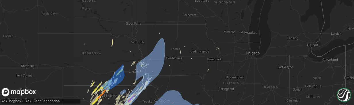
Hail Map in Iowa on May 6, 2024
The weather event in Iowa on May 6, 2024 includes Hail, Wind, and Tornado maps. 16 states and 1,500 cities were impacted and suffered possible damage. The total estimated number of properties impacted is 0.
Hail
Wind
Tornado
0
Estimated number of impacted properties by a 1.00" hail or larger0
Estimated number of impacted properties by a 1.75" hail or larger0
Estimated number of impacted properties by a 2.50" hail or largerStorm reports in Iowa
Iowa
| Date | Description |
|---|---|
| 05/06/20245:17 AM CDT | A local report indicates 1.00 inch wind near 2 WSW Riverdale |
| 05/06/20245:03 AM CDT | Many tree branches down in grand mound. Time estimated from radar. |
| 05/06/20245:03 AM CDT | Damage to the roof of a building. Owner says the roof paneling is rated to 90 mph. |
| 05/06/20244:56 AM CDT | Numerous branches down near vanderveer park. Some branches several inches thick. |
| 05/06/20244:56 AM CDT | Large tree down along with small branches through town. Time based on radar. |
| 05/06/20244:55 AM CDT | Large tree limbs down on a house. Public report via social media. Time estimated by radar. |
| 05/06/20244:35 AM CDT | A local report indicates 62 MPH wind near 2 S Sweetland Center |
| 05/06/20244:13 AM CDT | Trees down in west branch. Time based on radar. |
| 05/06/20244:08 AM CDT | 2 to 4 inch diameter branches down. |
| 05/06/20244:01 AM CDT | Branches down at this location. Report from social media. |
| 05/06/20243:45 AM CDT | Tree down. Report from social media. |
| 05/06/20243:35 AM CDT | Trees down between mt union and mt pleasant. |
| 05/06/20243:35 AM CDT | Awos station kmpz mount pleasant arpt. |
| 05/06/20243:30 AM CDT | Numerous reports of branches down on south side of town along with a couple of trees. Time based on radar. |
| 05/06/20243:05 AM CDT | Van horne rwis at us 30 and ia218. |
| 05/06/20242:59 AM CDT | Siding ripped from house and tree branches down. Report from social media... Time estimated by radar. |
| 05/06/20242:45 AM CDT | Branches down. Time based on radar. |
| 05/06/20242:29 AM CDT | Asos station kotm ottumwa regional airport. |
| 05/06/20242:18 AM CDT | Asos station kmiw marshalltown airport. |
| 05/06/20241:34 AM CDT | Emergency manager reported a tree fallen on a home. Power lines also down in the area. Time estimated from radar. |
| 05/06/20241:10 AM CDT | Trained spotter reported a tree and large branches down at the intersection of s23 and hwy 92. Time estimated from radar. |
| 05/06/202412:47 AM CDT | Emergency manager reported damage south of osceola... Including a snapped tree 2 feet in diameter and the western portion of the roof ripped off of a home. Time estimat |
| 05/05/202411:15 PM CDT | Large tree down along 3rd st. From who tv. Time estimated by radar. |
| 05/05/202410:04 PM CDT | Personal weather station. |
| 05/05/20249:59 PM CDT | Personal weather station measured gust. |
| 05/05/20249:31 PM CDT | From a personal weather station. |
| 05/05/20249:30 PM CDT | Empty grain bin blown off its foundation. Time estimated from radar. |
| 05/05/20249:21 PM CDT | From a personal weather station. |
| 05/05/20249:19 PM CDT | From a personal weather station. |
| 05/05/20249:18 PM CDT | Tornado debris signature confirmed on radar. |
| 05/05/20249:17 PM CDT | Power poles snapped. Likely from a tornado. |
| 05/05/20249:16 PM CDT | Tornado debris signature confirmed on radar. |
| 05/05/20249:16 PM CDT | Damage to a residence... Likely from a tornado. |
| 05/05/20249:15 PM CDT | Em reports that part of the roof of the new car wash in sutherland was ripped off... And several homes had tree branches land on them. |
| 05/05/20249:14 PM CDT | Power lines across the road. Possible damage to a residence likely from a tornado. |
| 05/05/20249:13 PM CDT | This ef1 tornado touched down at 9:10pm 2 miles southeast of minden causing ef1 damage to a transmission line. It then traveled northeast and damaged outbuildings and b |
| 05/05/20249:08 PM CDT | Large tree snapped. Several additional trees sheared off the top. |
| 05/05/20249:08 PM CDT | High tension powerlines blown down. |
| 05/05/20249:08 PM CDT | High tension power lines blown down. |
| 05/05/20249:07 PM CDT | Brief ef-1 tornado damage was observed 4 miles west/northwest of macedonia where two large trees were snapped and then lifted about a mile northeast of where one home s |
| 05/05/20249:05 PM CDT | From a personal weather station. |
| 05/05/20248:59 PM CDT | From a personal weather station. |
| 05/05/20248:58 PM CDT | From a personal weather station. |
| 05/05/20248:52 PM CDT | Damage to a home and multiple outbuildings. |
| 05/05/20248:48 PM CDT | An ef-1 tornado developed and snapped trees at a home on lucas road... Moving quickly to the northeast where it cut a 30 yard wide swath of snapped trees and branches. |
| 05/05/20248:09 PM CDT | Farm outbuildings had extreme roof damage. Time of damage estimated from radar. |
| 05/05/20247:25 PM CDT | Mesonet station rsyi4 sibley. |
All States Impacted by Hail Map on May 6, 2024
Cities Impacted by Hail Map on May 6, 2024
- Hoxie, KS
- Hermosa, SD
- Caputa, SD
- Jennings, KS
- Clayton, KS
- Norton, KS
- Penokee, KS
- Morland, KS
- Wilsonville, NE
- Hendley, NE
- Beaver City, NE
- Hill City, KS
- Lenora, KS
- Almena, KS
- Logan, KS
- Edison, NE
- Oxford, NE
- Wakeeney, KS
- Collyer, KS
- Arapahoe, NE
- Hammond, MT
- Boyes, MT
- Ekalaka, MT
- Prairie View, KS
- Louisville, GA
- Phillipsburg, KS
- Newell, SD
- Bogue, KS
- Quinn, SD
- Stockton, KS
- Long Island, KS
- Blythe, GA
- Augusta, GA
- Damar, KS
- Utica, KS
- Palco, KS
- Alma, NE
- Philip, SD
- Wall, SD
- Ogallah, KS
- Ellis, KS
- Spearville, KS
- Republican City, NE
- Wright, KS
- Ford, KS
- Harlem, GA
- Grovetown, GA
- Nicholson, GA
- Jefferson, GA
- Athens, GA
- Glade, KS
- Hayesville, NC
- Dodge City, KS
- Bucklin, KS
- Plainville, KS
- Offerle, KS
- Kinsley, KS
- Morrison, TN
- Altamont, TN
- Naponee, NE
- Mud Butte, SD
- Mountain Rest, SC
- Mcminnville, TN
- Beersheba Springs, TN
- Lewis, KS
- Hull, GA
- Lebanon, TN
- Colbert, GA
- Milesville, SD
- Cherry Creek, SD
- Linden, TN
- Mount Juliet, TN
- Salem, SC
- Tamassee, SC
- Howes, SD
- Agra, KS
- Kensington, KS
- Bloomington, NE
- Smith Center, KS
- Lobelville, TN
- Centerville, TN
- Bon Aqua, TN
- Lyles, TN
- Kirwin, KS
- North Augusta, SC
- Walhalla, SC
- Pickens, SC
- Woodston, KS
- Fairview, TN
- Franklin, TN
- Primm Springs, TN
- Garfield, KS
- Larned, KS
- Franklin, NE
- Riverton, NE
- Alton, KS
- Gaylord, KS
- Hays, KS
- Bethpage, TN
- Castalian Springs, TN
- Greensburg, KS
- Hartsville, TN
- Watertown, TN
- Tallahassee, FL
- Comer, GA
- Martin, GA
- Westminster, SC
- Toccoa, GA
- Cedar, KS
- Pawnee Rock, KS
- Protection, KS
- Coldwater, KS
- Murfreesboro, TN
- Athol, KS
- Gordonsville, TN
- Carthage, TN
- Thompsons Station, TN
- Murphy, NC
- Sunset, SC
- Six Mile, SC
- Edgefield, SC
- Easley, SC
- Inavale, NE
- Saluda, SC
- Johnston, SC
- Haviland, KS
- Alzada, MT
- Ewing, NE
- Matthews, GA
- Liberty, SC
- Catharine, KS
- Brush Creek, TN
- Albert, KS
- Otis, KS
- Natoma, KS
- Riddleton, TN
- Campbell, NE
- College Grove, TN
- Duck River, TN
- Hampshire, TN
- Williamsport, TN
- Mount Pleasant, TN
- Lebanon, KS
- Faith, SD
- Dupree, SD
- Inman, NE
- Sharon, OK
- Portis, KS
- Buffalo Valley, TN
- Page, NE
- Great Bend, KS
- Bladen, NE
- Elmwood, TN
- Chestnut Mound, TN
- Arnett, OK
- Thedford, NE
- Columbia, TN
- Woodward, OK
- Arrington, TN
- Rockvale, TN
- Eagleville, TN
- Orchard, NE
- Oneill, NE
- Red Cloud, NE
- Wilmore, KS
- Hoisington, KS
- Central, SC
- Waterford, MS
- Potts Camp, MS
- Greenville, SC
- Mooreland, OK
- Blue Hill, NE
- Burr Oak, KS
- Esbon, KS
- Mankato, KS
- Guide Rock, NE
- Glenvil, NE
- Ayr, NE
- Lawrence, NE
- St John, KS
- Smithville, TN
- Pratt, KS
- Byers, KS
- Iuka, KS
- Capitol, MT
- Piedmont, SC
- Nashville, TN
- Sylvania, GA
- Fairfax, SC
- Cheyenne, OK
- Claflin, KS
- Vici, OK
- Pendleton, SC
- Anderson, SC
- Antioch, TN
- Crawford, OK
- Liberty, TN
- Dowelltown, TN
- Demorest, GA
- Seneca, SC
- Baxter, TN
- Cookeville, TN
- Coats, KS
- Waynoka, OK
- Mutual, OK
- Williamston, SC
- Hammon, OK
- Pelzer, SC
- Leedey, OK
- Gatlinburg, TN
- Sparta, TN
- Sun City, KS
- Christiana, TN
- Hermitage, TN
- Inland, NE
- Hastings, NE
- Trumbull, NE
- Superior, NE
- Fairfield, NE
- Giltner, NE
- Deweese, NE
- Harvard, NE
- Nelson, NE
- Clay Center, NE
- Ellinwood, KS
- Holyrood, KS
- Bushton, KS
- Lorraine, KS
- Simpsonville, SC
- Smoaks, SC
- Ruffin, SC
- Gray Court, SC
- Fountain Inn, SC
- Stafford, KS
- Macksville, KS
- Woodruff, SC
- Only, TN
- McEwen, TN
- Nunnelly, TN
- Silver Point, TN
- Walling, TN
- Luray, SC
- Estill, SC
- Chester, OK
- Bell Buckle, TN
- Fairview, OK
- Alva, OK
- Taloga, OK
- Edgar, NE
- Camargo, OK
- Cosby, TN
- Sevierville, TN
- Turon, KS
- Beechgrove, TN
- Henderson, NE
- Stromsburg, NE
- Sutton, NE
- Bradshaw, NE
- Aurora, NE
- Benedict, NE
- Oak, NE
- Polk, NE
- Saronville, NE
- Hampton, NE
- Bradyville, TN
- Manchester, TN
- Geneva, NE
- Shickley, NE
- Ong, NE
- Davenport, NE
- Grafton, NE
- McCool Junction, NE
- Ruskin, NE
- Fairmont, NE
- York, NE
- Deshler, NE
- Ellsworth, KS
- Sylvia, KS
- Lincoln, KS
- Lyons, KS
- Quebeck, TN
- Doyle, TN
- Enoree, SC
- Mauldin, SC
- Plevna, KS
- Seiling, OK
- Ridgeland, SC
- Newport, TN
- Oakwood, OK
- Kanopolis, KS
- Walterboro, SC
- Winnsboro, SC
- Spencer, TN
- Abbyville, KS
- Sterling, KS
- Cleo Springs, OK
- Aline, OK
- Orangeburg, SC
- Cottageville, SC
- Ridgeville, SC
- Union, SC
- Clinton, SC
- Osceola, NE
- Gresham, NE
- Shelby, NE
- Waco, NE
- Carmen, OK
- Belvidere, NE
- Bruning, NE
- Strang, NE
- Carleton, NE
- Hebron, NE
- Hardy, NE
- Helena, OK
- Canton, OK
- Saint George, SC
- Tescott, KS
- Brookville, KS
- Whitmire, SC
- Commerce, GA
- Concordia, KS
- Aurora, KS
- Butler, OK
- Sawyer, KS
- Nickerson, KS
- Bells, TN
- Gadsden, TN
- Ohiowa, NE
- Exeter, NE
- Milligan, NE
- Longdale, OK
- Southard, OK
- Belleville, KS
- Clyde, KS
- Agenda, KS
- Clifton, KS
- Goltry, OK
- Jet, OK
- Miltonvale, KS
- Minneapolis, KS
- Delphos, KS
- Guyton, GA
- Laurens, SC
- Salina, KS
- Windom, KS
- Inman, KS
- Hutchinson, KS
- Little River, KS
- Greeneville, TN
- Putnam, OK
- Marshall, NC
- Hillsboro, TN
- Nash, OK
- Pond Creek, OK
- Okeene, OK
- Isabella, OK
- Lemmon, SD
- Watonga, OK
- Mcpherson, KS
- Lindsborg, KS
- Tillman, SC
- Hardeeville, SC
- Sayre, OK
- Lucas, KS
- Osborne, KS
- Luray, KS
- Bennington, KS
- Wisner, NE
- Clay Center, KS
- Marquette, KS
- Hitchcock, OK
- Custer City, OK
- Kingfisher, OK
- Gypsum, KS
- Hettinger, ND
- Afton, TN
- Chuckey, TN
- Bloomingdale, GA
- Spring Hill, TN
- Elk City, OK
- Assaria, KS
- Galva, KS
- Solomon, KS
- Linn, KS
- Hennessey, OK
- Ames, OK
- Abilene, KS
- Hope, KS
- Drummond, OK
- Waukomis, OK
- Chapman, KS
- Enterprise, KS
- Medford, OK
- Tampa, KS
- Durham, KS
- Enid, OK
- Washington, KS
- Morganville, KS
- Rincon, GA
- Ellabell, GA
- New Cambria, KS
- Limestone, TN
- Telford, TN
- Talmage, KS
- Woodbine, KS
- Wakefield, KS
- Clinton, OK
- Arapaho, OK
- Weatherford, OK
- Junction City, KS
- Dwight, NE
- Palmer, KS
- Longford, KS
- Bison, OK
- Lewisburg, TN
- Port Wentworth, GA
- Florence, SC
- Scooba, MS
- Abbeville, SC
- Donalds, SC
- Fort Riley, KS
- Milford, KS
- Riley, KS
- Lamont, OK
- Deer Creek, OK
- Manhattan, KS
- Ogden, KS
- Randolph, KS
- Leonardville, KS
- Thomas, OK
- Odell, NE
- Wymore, NE
- Blue Springs, NE
- Weston, NE
- Prague, NE
- Valparaiso, NE
- Malmo, NE
- Honea Path, SC
- Greenleaf, KS
- Barnard, KS
- Beatrice, NE
- Chapel Hill, TN
- Lascassas, TN
- Granite Falls, NC
- Nardin, OK
- Marshall, OK
- Douglas, OK
- Fairmont, OK
- Olsburg, KS
- Blue Rapids, KS
- Colon, NE
- Cedar Bluffs, NE
- Hodges, SC
- Waterville, KS
- Barnes, KS
- Adams, NE
- Filley, NE
- Virginia, NE
- Readyville, TN
- Blackwell, OK
- Braman, OK
- Saint George, KS
- Frankfort, KS
- Westmoreland, KS
- Covington, OK
- Lucien, OK
- Orlando, OK
- Vermillion, KS
- Axtell, KS
- Ames, NE
- South Haven, KS
- Oxford, KS
- Geuda Springs, KS
- Glasco, KS
- Beloit, KS
- Cedar Vale, KS
- Taylorsville, NC
- Beverly, KS
- Ware Shoals, SC
- Oketo, KS
- Pigeon Forge, TN
- Woodbury, TN
- Perry, OK
- Waterloo, SC
- Unadilla, NE
- Newkirk, OK
- Arkansas City, KS
- Belton, SC
- Winfield, KS
- Lincoln, NE
- Bethune, SC
- Kershaw, SC
- Chase, KS
- Geary, OK
- Grenola, KS
- Cambridge, KS
- Dexter, KS
- Severy, KS
- Onaga, KS
- Rock, KS
- Baileyville, KS
- West Union, SC
- Greenfield, OK
- Loyal, OK
- Table Rock, NE
- Johnson, NE
- Humboldt, NE
- Auburn, NE
- Shidler, OK
- Geneseo, KS
- Cushing, OK
- Lenoir, NC
- Statesville, NC
- Stony Point, NC
- Dandridge, TN
- Brentwood, TN
- Syracuse, NE
- Avoca, NE
- Elmwood, NE
- Weeping Water, NE
- Lancaster, TN
- Seneca, KS
- Goff, KS
- Corning, KS
- Centralia, KS
- Home, KS
- Marysville, KS
- Summerfield, KS
- Liberty, NE
- Steinauer, NE
- Beattie, KS
- Burchard, NE
- Du Bois, NE
- Pawnee City, NE
- Green, KS
- Tecumseh, NE
- Crab Orchard, NE
- La Vista, NE
- Papillion, NE
- Omaha, NE
- Springfield, NE
- Yale, OK
- Brock, NE
- Omega, OK
- Valley, NE
- Okarche, OK
- Calumet, OK
- Elkhorn, NE
- Bennington, NE
- Cross Hill, SC
- Kennard, NE
- Bern, KS
- Sterling, NE
- Falun, KS
- Panama, NE
- Walton, NE
- Hickman, NE
- Roca, NE
- Bennet, NE
- Firth, NE
- Palmyra, NE
- Douglas, NE
- Waverly, NE
- Pickrell, NE
- Eagle, NE
- Burr, NE
- Murdock, NE
- Ceresco, NE
- Alvo, NE
- Wahoo, NE
- Ashland, NE
- Ithaca, NE
- Greenwood, NE
- Gretna, NE
- Mead, NE
- Dunbar, NE
- Manley, NE
- South Bend, NE
- Glenwood, IA
- Otoe, NE
- Nebraska City, NE
- Nehawka, NE
- Murray, NE
- Union, NE
- Yutan, NE
- Memphis, NE
- Pacific Junction, IA
- Cedar Creek, NE
- Plattsmouth, NE
- Louisville, NE
- Bellevue, NE
- Waterloo, NE
- Council Bluffs, IA
- Boys Town, NE
- Crescent, IA
- Offutt Afb, NE
- Fort Calhoun, NE
- Carter Lake, IA
- Blair, NE
- Washington, NE
- Cook, NE
- Hamburg, IA
- Lorton, NE
- Sidney, IA
- Talmage, NE
- Thurman, IA
- Percival, IA
- Tabor, IA
- Mountville, SC
- Shenandoah, IA
- Dawson, NE
- Stella, NE
- Verdon, NE
- Fort Stewart, GA
- Hiddenite, NC
- Norris, SC
- Sabetha, KS
- Oneida, KS
- Terlton, OK
- Rock Port, MO
- Brownville, NE
- Nemaha, NE
- Peru, NE
- Elk Creek, NE
- Julian, NE
- Riverton, IA
- Shubert, NE
- Morrill, KS
- Salem, NE
- Watson, MO
- Falls City, NE
- Cleveland, OK
- Logan, IA
- Honey Creek, IA
- Underwood, IA
- Malvern, IA
- Missouri Valley, IA
- Silver City, IA
- Hastings, IA
- Oakland, IA
- Randolph, IA
- McClelland, IA
- Mineola, IA
- Henderson, IA
- Minden, IA
- Emerson, IA
- Macedonia, IA
- Treynor, IA
- Carson, IA
- Neola, IA
- Imogene, IA
- Farragut, IA
- Tarkio, MO
- Westboro, MO
- Fairfax, MO
- Osage, OK
- Hominy, OK
- Townville, SC
- Arlington, NE
- Fleming, GA
- Fairfax, OK
- Pawnee, OK
- Howard, KS
- Fall River, KS
- Stillwater, OK
- Sedan, KS
- Shelby, IA
- Northboro, IA
- Coin, IA
- Craig, MO
- Blanchard, IA
- Essex, IA
- Red Oak, IA
- Hancock, IA
- Walnut, IA
- Persia, IA
- Griswold, IA
- Elliott, IA
- Avoca, IA
- Woodbine, IA
- Harlan, IA
- Earling, IA
- Panama, IA
- Dunlap, IA
- Portsmouth, IA
- Burden, KS
- Atlanta, KS
- Latham, KS
- Piedmont, KS
- Eureka, KS
- Richmond Hill, GA
- Wellsville, KS
- Barnsdall, OK
- Crescent, OK
- Moline, KS
- Elk Falls, KS
- Independence, KS
- Longton, KS
- Elk City, KS
- Caney, KS
- Niotaze, KS
- Peru, KS
- Havana, KS
- Bartlesville, OK
- Manilla, IA
- Irwin, IA
- Westphalia, IA
- Defiance, IA
- Kirkman, IA
- Brayton, IA
- Atlantic, IA
- Exira, IA
- Audubon, IA
- Marne, IA
- Kimballton, IA
- Elk Horn, IA
- Lewis, IA
- Wiota, IA
- Clarinda, IA
- Grant, IA
- Yorktown, IA
- Villisca, IA
- Corning, IA
- Cumberland, IA
- Stanton, IA
- Braddyville, IA
- College Springs, IA
- Elmo, MO
- Cleveland, NC
- Dobson, NC
- Cashion, OK
- Eudora, KS
- Fredonia, KS
- Neal, KS
- Toronto, KS
- Virgil, KS
- Neosho Falls, KS
- Buffalo, KS
- Neodesha, KS
- Yates Center, KS
- Le Roy, KS
- Benedict, KS
- Gridley, KS
- Burlington, KS
- Piqua, KS
- Cherryvale, KS
- Thayer, KS
- Chanute, KS
- Mound Valley, KS
- Coffeyville, KS
- Liberty, KS
- Tyro, KS
- Altoona, KS
- Dearing, KS
- Edna, KS
- Parsons, KS
- Dennis, KS
- Altamont, KS
- Galesburg, KS
- Humboldt, KS
- Iola, KS
- Dewey, OK
- Erie, KS
- Girard, KS
- Savonburg, KS
- McCune, KS
- Columbus, KS
- Walnut, KS
- West Mineral, KS
- Chetopa, KS
- Scammon, KS
- Saint Paul, KS
- Colony, KS
- Oswego, KS
- Mapleton, KS
- Moran, KS
- Redfield, KS
- Uniontown, KS
- Weir, KS
- Pittsburg, KS
- Mound City, KS
- Welda, KS
- Fort Scott, KS
- Kincaid, KS
- Hepler, KS
- Bronson, KS
- Farlington, KS
- Westphalia, KS
- Stark, KS
- Blue Mound, KS
- La Harpe, KS
- Elsmore, KS
- Cherokee, KS
- Centerville, KS
- Garnett, KS
- Wynona, OK
- Guthrie, OK
- Pawhuska, OK
- Mulhall, OK
- Edmond, OK
- Carroll, IA
- Wall Lake, IA
- Arcadia, IA
- Vail, IA
- Sac City, IA
- Westside, IA
- Manning, IA
- Lake View, IA
- Breda, IA
- Halbur, IA
- Aspinwall, IA
- Templeton, IA
- Auburn, IA
- Denison, IA
- Gray, IA
- Dow City, IA
- Anita, IA
- Coon Rapids, IA
- Guthrie Center, IA
- Dedham, IA
- Adair, IA
- Hamlin, IA
- Bridgewater, IA
- Carbon, IA
- Fontanelle, IA
- Nodaway, IA
- Massena, IA
- New Market, IA
- Gravity, IA
- Prescott, IA
- Shambaugh, IA
- Lenox, IA
- Skidmore, MO
- Burlington Junction, MO
- Clearmont, MO
- Rulo, NE
- Bedford, IA
- Coyle, OK
- Ochelata, OK
- Meridian, OK
- Muskogee, OK
- Dover, OK
- Skiatook, OK
- Ramona, OK
- Talala, OK
- Wagoner, OK
- Perkins, OK
- Wellston, OK
- Nowata, OK
- Delaware, OK
- Ottawa, KS
- Rantoul, KS
- Porter, OK
- Carney, OK
- Tryon, OK
- Carnegie, OK
- Fort Cobb, OK
- Galena, KS
- Locust Grove, OK
- Cordell, OK
- Roosevelt, OK
- Agra, OK
- Gracemont, OK
- Binger, OK
- Anadarko, OK
- Lidderdale, IA
- Palmer, IA
- Jolley, IA
- Rockwell City, IA
- Glidden, IA
- Fonda, IA
- Pocahontas, IA
- Lake City, IA
- Lanesboro, IA
- Lohrville, IA
- Manson, IA
- Lytton, IA
- Pomeroy, IA
- Sharpsburg, IA
- Casey, IA
- Greenfield, IA
- Creston, IA
- Orient, IA
- Stuart, IA
- Churdan, IA
- Menlo, IA
- Gowrie, IA
- Jefferson, IA
- Bagley, IA
- Yale, IA
- Bayard, IA
- Panora, IA
- Ralston, IA
- Scranton, IA
- Somers, IA
- Paton, IA
- Farnhamville, IA
- Chandler, OK
- Stroud, OK
- Salina, OK
- Rose, OK
- Eucha, OK
- Jennings, OK
- Drumright, OK
- Welch, OK
- Colcord, OK
- Arcadia, OK
- Luther, OK
- Mountain View, OK
- Greeley, KS
- Lane, KS
- Richmond, KS
- Baldwin City, KS
- Williamsburg, KS
- Princeton, KS
- Parker, KS
- Waverly, KS
- Lenapah, OK
- S Coffeyville, OK
- Wann, OK
- Bronaugh, MO
- Amoret, MO
- Vinita, OK
- Mulberry, KS
- Arma, KS
- Osawatomie, KS
- Fontana, KS
- Bartlett, KS
- Deerfield, MO
- Fulton, KS
- Pleasanton, KS
- La Cygne, KS
- Paola, KS
- Copan, OK
- Franklin, KS
- Liberal, MO
- Rich Hill, MO
- Prescott, KS
- Butler, MO
- Mindenmines, MO
- Frontenac, KS
- Foster, MO
- Amsterdam, MO
- Richards, MO
- Hume, MO
- Arcadia, KS
- Garland, KS
- Baxter Springs, KS
- Chelsea, OK
- Bluejacket, OK
- Miami, OK
- Afton, OK
- Moundville, MO
- Treece, KS
- Asbury, MO
- North Miami, OK
- Nevada, MO
- Opolis, KS
- Commerce, OK
- Picher, OK
- Adair, OK
- Big Cabin, OK
- Riverton, KS
- Joplin, MO
- Carl Junction, MO
- Fairland, OK
- Wyandotte, OK
- Quapaw, OK
- New Century, KS
- Olathe, KS
- Mission, KS
- Louisburg, KS
- Edgerton, KS
- Gardner, KS
- Bonner Springs, KS
- Stilwell, KS
- Belton, MO
- Kansas City, KS
- Lenexa, KS
- Linwood, KS
- Basehor, KS
- Leawood, KS
- De Soto, KS
- Cleveland, MO
- Kansas City, MO
- Spring Hill, KS
- Bucyrus, KS
- Adrian, MO
- Peculiar, MO
- Drexel, MO
- Prairie Village, KS
- Freeman, MO
- Shawnee, KS
- Overland Park, KS
- Callender, IA
- Clare, IA
- Barnum, IA
- Moorland, IA
- Knierim, IA
- Gilmore City, IA
- Jay, OK
- Glencoe, OK
- Spavinaw, OK
- Curlew, IA
- Tahlequah, OK
- Mannford, OK
- Minco, OK
- Ripley, OK
- Lookeba, OK
- Davenport, OK
- Grandview, MO
- Independence, MO
- Lees Summit, MO
- Pleasant Hill, MO
- Archie, MO
- Harrisonville, MO
- Raymore, MO
- Greenwood, MO
- Blue Springs, MO
- Garden City, MO
- East Lynne, MO
- Grain Valley, MO
- Creighton, MO
- Pocasset, OK
- Mallard, IA
- Emmetsburg, IA
- Kansas, OK
- Twin Oaks, OK
- Sand Springs, OK
- Jones, OK
- Proctor, OK
- Tuttle, OK
- Blanchard, OK
- Newcastle, OK
- Oklahoma City, OK
- Mustang, OK
- Union City, OK
- Yukon, OK
- Wheatland, OK
- Depew, OK
- Tulsa, OK
- Union Star, MO
- King City, MO
- Decatur, AR
- Gravette, AR
- Maysville, AR
- Gentry, AR
- Noel, MO
- Loveland, OK
- Bristow, OK
- Choctaw, OK
- Spencer, OK
- Harrah, OK
- Newalla, OK
- Walters, OK
- Norman, OK
- Bella Vista, AR
- Pineville, MO
- Carthage, MO
- Oronogo, MO
- Seneca, MO
- Webb City, MO
- Diamond, MO
- Carterville, MO
- Duenweg, MO
- Neosho, MO
- Jasper, MO
- Granby, MO
- Stotts City, MO
- Brighton, MO
- Warsaw, MO
- Arcola, MO
- Strasburg, MO
- Fair Play, MO
- Bolivar, MO
- Warrensburg, MO
- Sarcoxie, MO
- Clever, MO
- Chilhowee, MO
- Stockton, MO
- Willard, MO
- Blairstown, MO
- Marionville, MO
- Lincoln, MO
- Rockville, MO
- Fair Grove, MO
- Pierce City, MO
- Mount Vernon, MO
- Nixa, MO
- Osceola, MO
- Monett, MO
- Billings, MO
- Buckner, MO
- Appleton City, MO
- Clinton, MO
- Oak Grove, MO
- Cross Timbers, MO
- Windsor, MO
- Ash Grove, MO
- Edwards, MO
- Alba, MO
- Lone Jack, MO
- Urich, MO
- Avilla, MO
- Knob Noster, MO
- Montrose, MO
- Collins, MO
- Purcell, MO
- Verona, MO
- Schell City, MO
- Milo, MO
- Louisburg, MO
- Hermitage, MO
- Sheldon, MO
- Preston, MO
- Dadeville, MO
- Reeds, MO
- Morrisville, MO
- Weaubleau, MO
- Centerview, MO
- Lowry City, MO
- Walnut Grove, MO
- Aldrich, MO
- South Greenfield, MO
- Quincy, MO
- Freistatt, MO
- Pittsburg, MO
- Aurora, MO
- Golden City, MO
- Lamar, MO
- Walker, MO
- Deepwater, MO
- Half Way, MO
- Bois D Arc, MO
- La Russell, MO
- Greenfield, MO
- Republic, MO
- Urbana, MO
- Humansville, MO
- Pleasant Hope, MO
- Odessa, MO
- Lockwood, MO
- Leeton, MO
- Green Ridge, MO
- Miller, MO
- Calhoun, MO
- Dunnegan, MO
- Brookline, MO
- Flemington, MO
- Buffalo, MO
- Bates City, MO
- Wentworth, MO
- Harwood, MO
- Neck City, MO
- Holden, MO
- El Dorado Springs, MO
- Everton, MO
- Halltown, MO
- Jerico Springs, MO
- Polk, MO
- Kingsville, MO
- Springfield, MO
- Wheatland, MO
- Higginsville, MO
- Shawnee, OK
- Mcloud, OK
- Meeker, OK
- Jenks, OK
- Broken Arrow, OK
- Catoosa, OK
- Stella, MO
- Geronimo, OK
- Powell, MO
- Rocky Comfort, MO
- Washington, OK
- Okemah, OK
- Castle, OK
- Murray, IA
- Lorimor, IA
- Noble, OK
- Okmulgee, OK
- Beggs, OK
- Tecumseh, OK
- Fairview, MO
- Wheaton, MO
- Earlsboro, OK
- Purcell, OK
- Seminole, OK
- Morris, OK
- Duncan, OK
- Boynton, OK
- Chouteau, OK
- Oktaha, OK
- Haskell, OK
- Purdy, MO
- Wewoka, OK
- Harleyville, SC
- Crane, MO
- Taft, OK
- Fort Gibson, OK
- Highlandville, MO
- Oaks, OK
- Checotah, OK
- Peggs, OK
- Sparta, MO
- Council Hill, OK
- Cape Fair, MO
- Braggs, OK
- Park Hill, OK
- Wellington, MO
- Lexington, MO
- Mayview, MO
- Sibley, MO
- Napoleon, MO
- Corder, MO
- Whiteman Air Force Base, MO
- Concordia, MO
- Sedalia, MO
- Levasy, MO
- Cole Camp, MO
- Alma, MO
- Ionia, MO
- Henrietta, MO
- Malta Bend, MO
- Houstonia, MO
- Camden, MO
- Sweet Springs, MO
- Marshall, MO
- Hughesville, MO
- Blackburn, MO
- Orrick, MO
- La Monte, MO
- Otterville, MO
- Nelson, MO
- Stover, MO
- Mora, MO
- Smithton, MO
- Blackwater, MO
- Pilot Grove, MO
- Slater, MO
- Florence, MO
- Russellville, MO
- Latham, MO
- Auxvasse, MO
- Camdenton, MO
- Harrisburg, MO
- Fortuna, MO
- Fayette, MO
- Higbee, MO
- New Franklin, MO
- Sunrise Beach, MO
- Arrow Rock, MO
- Barnett, MO
- Boonville, MO
- Bunceton, MO
- Rocheport, MO
- Sturgeon, MO
- Franklin, MO
- Syracuse, MO
- Centralia, MO
- Prairie Home, MO
- Versailles, MO
- Ashland, MO
- Macks Creek, MO
- Roach, MO
- Climax Springs, MO
- Centertown, MO
- Gravois Mills, MO
- Tipton, MO
- Hartsburg, MO
- Rocky Mount, MO
- Columbia, MO
- Clarksburg, MO
- Eldon, MO
- Clark, MO
- Hallsville, MO
- Tunas, MO
- Thompson, MO
- Mexico, MO
- Jamestown, MO
- Wooldridge, MO
- Glasgow, MO
- California, MO
- Waverly, MO
- Olean, MO
- Saint Thomas, MO
- Fulton, MO
- Kingdom City, MO
- Eugene, MO
- Jefferson City, MO
- Kaiser, MO
- Tuscumbia, MO
- Linn Creek, MO
- Tebbetts, MO
- New Bloomfield, MO
- Holts Summit, MO
- Bonnots Mill, MO
- Osage Beach, MO
- Westphalia, MO
- Lohman, MO
- Lake Ozark, MO
- Henley, MO
- Mokane, MO
- Strafford, MO
- Rogersville, MO
- Ozark, MO
- Marshfield, MO
- Elkland, MO
- Fordland, MO
- Long Lane, MO
- Chadwick, MO
- Oldfield, MO
- Bruner, MO
- Niangua, MO
- Seymour, MO
- Conway, MO
- Cookson, OK
- Welling, OK
- Galena, MO
- Dustin, OK
- Stilwell, OK
- Eufaula, OK
- Reeds Spring, MO
- Ava, MO
- Mansfield, MO
- Hartville, MO
- Grovespring, MO
- Lebanon, MO
- Falcon, MO
- Laquey, MO
- Bunch, OK
- Warner, OK
- Porum, OK
- Webbers Falls, OK
- Stigler, OK
- Vian, OK
- Gore, OK
- Sallisaw, OK
- Muldrow, OK
- Richland, MO
- Fort Leonard Wood, MO
- Edgar Springs, MO
- Duke, MO
- Newburg, MO
- Waynesville, MO
- Saint Robert, MO
- Dixon, MO
- Devils Elbow, MO
- Parthenon, AR
- Jasper, AR
- Melbourne, IA
- Rhodes, IA
- Baxter, IA
- State Center, IA
- Watts, OK
- Westville, OK
- Hanna, OK
- Rhineland, MO
- Williamsburg, MO
- Loose Creek, MO
- Montgomery City, MO
- Freeburg, MO
- Steedman, MO
- Meta, MO
- Hermann, MO
- Koeltztown, MO
- Belle, MO
- Morrison, MO
- Chamois, MO
- Bland, MO
- Portland, MO
- Linn, MO
- Mount Sterling, MO
- Drury, MO
- Norwood, MO
- Vanzant, MO
- Macomb, MO
- Mountain Grove, MO
- Jerome, MO
- Rolla, MO
- Vichy, MO
- Vienna, MO
- Brinktown, MO
- Crocker, MO
- Natural Dam, AR
- Evansville, AR
- Canehill, AR
- Prairie Grove, AR
- West Fork, AR
- Conrad, IA
- Beaman, IA
- Van Buren, AR
- Alma, AR
- Charleston, AR
- Cecil, AR
- Gans, OK
- Roland, OK
- Rudy, AR
- Mountainburg, AR
- Uniontown, AR
- Cedarville, AR
- Dyer, AR
- Lavaca, AR
- Mulberry, AR
- Fort Smith, AR
- Arkoma, OK
- Winslow, AR
- Chester, AR
- Elkins, AR
- Keota, OK
- Ozark, AR
- Riverside, MO
- Missouri City, MO
- Holt, MO
- Excelsior Springs, MO
- Kearney, MO
- Liberty, MO
- Smithville, MO
- Cameron, MO
- Rayville, MO
- Norborne, MO
- Braymer, MO
- Lathrop, MO
- Polo, MO
- Hardin, MO
- Richmond, MO
- Hamilton, MO
- Cowgill, MO
- Lawson, MO
- Dover, MO
- Kingston, MO
- Carrollton, MO
- Trimble, MO
- Breckenridge, MO
- Ludlow, MO
- Dawn, MO
- Bogard, MO
- Miami, MO
- Bosworth, MO
- Chillicothe, MO
- Hale, MO
- Gilliam, MO
- De Witt, MO
- Tina, MO
- Kidder, MO
- Turney, MO
- Triplett, MO
- Brunswick, MO
- Sumner, MO
- Fayetteville, AR
- Deep River, IA
- Altus, AR
- Coal Hill, AR
- Cabool, MO
- Graff, MO
- Clarksville, AR
- Hartman, AR
- Ozone, AR
- Lamar, AR
- Sullivan, MO
- Bourbon, MO
- Oark, AR
- Hagarville, AR
- Eminence, MO
- Summersville, MO
- Pelsor, AR
- Dover, AR
- Burlington, IA
- Gladstone, IL
- Hector, AR
- New Boston, IL
- Joy, IL
- Monmouth, IL
- Kirkwood, IL
- Aledo, IL
- Little York, IL
- Alexis, IL
- Milan, IL
- Yellville, AR
- Flippin, AR
- Berwick, IL
- Avon, IL
- Sherrard, IL
- Coal Valley, IL
- Moline, IL
- Miles, IA
- Sabula, IA
- De Witt, IA
- Bellevue, IA
- Preston, IA
- Savanna, IL
- Galena, IL
- Pekin, IL
- Delavan, IL
- Tremont, IL
- Mackinaw, IL
- Danvers, IL
- Deer Creek, IL
- Goodfield, IL
- Bettendorf, IA


