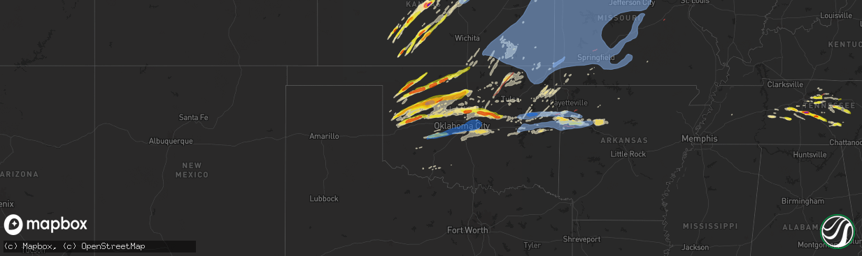
Hail Map in Oklahoma on May 6, 2024
The weather event in Oklahoma on May 6, 2024 includes Hail, Wind, and Tornado maps. 16 states and 1,500 cities were impacted and suffered possible damage. The total estimated number of properties impacted is 29,978.
Hail
Wind
Tornado
29,978
Estimated number of impacted properties by a 1.00" hail or larger11,941
Estimated number of impacted properties by a 1.75" hail or larger1,175
Estimated number of impacted properties by a 2.50" hail or largerStorm reports in Oklahoma
Oklahoma
| Date | Description |
|---|---|
| 05/06/20246:59 PM CDT | Spotternetwork report. Trees uprooted... Power lines snapped... Single home structure damage. Time is radar estimate. Possible tornado damage. |
| 05/06/20246:57 PM CDT | Report from mping. |
| 05/06/20246:55 PM CDT | Power poles down and tree damage at hwy 51 and south hwy 132. |
| 05/06/20246:45 PM CDT | A local report indicates 1.75 inch wind near Okeene |
| 05/06/20246:43 PM CDT | A local report indicates a tornado near 4 SE Okeene |
| 05/06/20246:37 PM CDT | Report from mping. |
| 05/06/20246:35 PM CDT | Photo relayed through nwschat. |
| 05/06/20246:15 PM CDT | A local report indicates 65 MPH wind near 3 N Putnam |
| 05/06/20246:10 PM CDT | Twitter photo with noted melting; time estimated based on radar. |
| 05/06/20246:09 PM CDT | Report relayed by nws employee. |
| 05/06/20245:55 PM CDT | A local report indicates 1.75 inch wind near Oakwood |
| 05/06/20245:33 PM CDT | Time estimated based on radar. |
| 05/06/20245:15 PM CDT | A local report indicates 61 MPH wind near 7 SSW Alva |
| 05/06/20245:09 PM CDT | A local report indicates 82 MPH wind near 9 N Chester |
| 05/06/20244:20 PM CDT | A local report indicates 1.75 inch wind near 4 SE Woodward |
| 05/06/20244:18 PM CDT | Report from mping. |
| 05/06/20244:10 PM CDT | Corrects previous hail report from 4 se woodward. Time estimated based on radar. |
| 05/06/202411:42 AM CDT | Corrects previous tstm wnd gst report from 2 se valley brook. Time estimated from radar. Report from 89th and bryant. |
| 05/06/202411:42 AM CDT | Corrects previous tstm wnd gst report from 2 se valley brook. Corrects previous tstm wnd gst report from 2 se valley brook. Time estimated from radar. Report from 89th |
| 05/06/202411:38 AM CDT | Fence damage. Facebook report with picture. Time estimated from radar. |
| 05/06/202410:38 AM CDT | Sw 119th between s. Western and s. Penn. Damaged power poles. Facebook report with picture. Time est. From radar. |
| 05/06/20241:29 AM CDT | 60 mph gust at davis field |
| 05/06/20241:20 AM CDT | Power outages and trees broken. Time estimated via radar. |
| 05/06/20241:17 AM CDT | Estimated winds. Trees blocking roads near davis airport. |
| 05/06/202412:50 AM CDT | Several reports of tree damage... Plus damage to carports and a couple of barns in muskogee county. Time of report based on radar data. |
| 05/06/202412:43 AM CDT | Nwschat report. |
| 05/06/202412:34 AM CDT | 50 to 60 mph winds reported near okmulgee by broadcast media storm chaser. |
| 05/06/202412:12 AM CDT | Downed tree limbs. Fb report. Time est. From radar. |
| 05/05/202411:56 PM CDT | A local report indicates 65 MPH wind near 8 SE Oklahoma City |
| 05/05/202411:56 PM CDT | Down trees. Buck rd. Next to twin lakes. Fb report. Time estimated from radar. |
| 05/05/202411:55 PM CDT | 3-inch tree limbs broken; power poles broken. |
| 05/05/202411:55 PM CDT | A local report indicates 66 MPH wind near Tinker Air Force Base |
| 05/05/202411:55 PM CDT | 3-inch tre |
| 05/05/202411:51 PM CDT | Nwschat report. |
| 05/05/202411:50 PM CDT | Powerlines and tree limbs blown down. Radar estimated time. |
| 05/05/202411:48 PM CDT | Snapped tree trunk. Midwest city near reno. Fb report. Time estimated from radar. |
| 05/05/202411:47 PM CDT | Downed tree. Facebook report with picture. Time est. From radar. |
| 05/05/202411:46 PM CDT | South side of wood fence gone. North rock creek. Facebook with picture. Time estimated from radar. |
| 05/05/202411:45 PM CDT | Powerline down. Spotter network report. Radar estimated time. |
| 05/05/202411:44 PM CDT | Downed tree. Facebook report with picture. Time based on radar. |
| 05/05/202411:44 PM CDT | Corrects previous tstm wnd dmg report from 3 wnw moore. Sw 119th between s. Western and s. Penn. Damaged power poles. Facebook report with picture. Time est. From radar |
| 05/05/202411:43 PM CDT | Power poles down on bryant between se 19th and se 4th street. Fb report. Time estimated on radar. |
| 05/05/202411:42 PM CDT | Overturned semi-trailer. Time estimated from radar. Facebook report with picture. |
| 05/05/202411:42 PM CDT | Damage to webster middle school soccer goals. Facebook report with picture. Time estimated from radar. |
| 05/05/202411:42 PM CDT | Corrects previous tstm wnd gst report from 2 se valley brook. Corrects previous tstm wnd gst report from 2 se valley brook. Corrects previous tstm wnd gst report from 2 |
| 05/05/202411:42 PM CDT | A local report indicates 1.00 inch wind near 2 SE Valley Brook |
| 05/05/202411:39 PM CDT | Snapped tree. |
| 05/05/202411:38 PM CDT | A local report indicates 69 MPH wind near 6 SW Oklahoma City |
| 05/05/202411:35 PM CDT | Report from mping: golf ball |
| 05/05/202411:30 PM CDT | A local report indicates 71 MPH wind near 2 SSW Minco |
| 05/05/202411:30 PM CDT | Report from mping: 3-inch tree limbs broken; power poles broken. |
| 05/05/202411:30 PM CDT | Powerlines and tree branches blown down. Radar estimated time. |
| 05/05/202411:30 PM CDT | Damaged power poles |
| 05/05/202411:27 PM CDT | Report from mping. |
| 05/05/202411:25 PM CDT | Report from mping. |
| 05/05/202411:25 PM CDT | A local report indicates 64 MPH wind near 2 SSW Minco |
| 05/05/202411:20 PM CDT | A local report indicates 59 MPH wind near 2 SSW Minco |
| 05/05/202411:02 PM CDT | Report from mping. |
| 05/05/202411:00 PM CDT | Damage to welch schools... Including to the roof of the gymnasium. |
| 05/05/202410:50 PM CDT | Vinita mesonet. |
| 05/05/202410:45 PM CDT | A local report indicates 59 MPH wind near 4 NNW Fort Cobb |
| 05/05/202410:39 PM CDT | Report from mping. |
| 05/05/202410:26 PM CDT | Damage to homes and power lines down approximately 1 mile south and 2 miles east of south coffeyville. |
| 05/05/202410:24 PM CDT | A local report indicates 1.75 inch wind near 7 SSE Guthrie |
| 05/05/202410:22 PM CDT | Report from mping. |
| 05/05/202410:21 PM CDT | Report from mping. |
| 05/05/202410:20 PM CDT | A local report indicates 59 MPH wind near Talala |
| 05/05/202410:04 PM CDT | A local report indicates 59 MPH wind near 3 NW Stillwater |
| 05/05/202410:00 PM CDT | Damage near the hampton inn at 75 and tuxedo blvd in bartlesville likely due to a tornado. |
| 05/05/20249:40 PM CDT | Corrects previous rain report from 4 sse marshall. Its wind... Not rain. |
| 05/05/20249:40 PM CDT | Multiple reports of structural damage and multiple chaser photos and videos of a tornado in and near barnsdall. |
| 05/05/20249:24 PM CDT | Hominy pd report relayed via emergency management. |
| 05/05/20249:13 PM CDT | Re |
| 05/05/20249:13 PM CDT | Report from mping; time is estimated based on radar. |
| 05/05/20249:04 PM CDT | 65 to 75 mph winds estimated by a broadcast media storm chaser on highway 60 east of burbank. |
| 05/05/20248:12 PM CDT | Snapped power lines reported via spotter network; time estimated based on radar. |
| 05/05/20247:53 PM CDT | Relayed via nwschat; at the intersection of state hwy 74 and flynn rd. |
| 05/05/20247:45 PM CDT | Uprooted tree. Facebook report with picture. |
| 05/05/20247:27 PM CDT | Initial spotternetwork report of a rope tornado... Also confirmed by broadcast media. |
| 05/05/20247:27 PM CDT | Barn destroyed. 8 miles east and 5 miles north of hennessey. Facebook report. |
| 05/05/20247:15 PM CDT | Report from mping. |
All States Impacted by Hail Map on May 6, 2024
Cities Impacted by Hail Map on May 6, 2024
- Hoxie, KS
- Hermosa, SD
- Caputa, SD
- Jennings, KS
- Clayton, KS
- Norton, KS
- Penokee, KS
- Morland, KS
- Wilsonville, NE
- Hendley, NE
- Beaver City, NE
- Hill City, KS
- Lenora, KS
- Almena, KS
- Logan, KS
- Edison, NE
- Oxford, NE
- Wakeeney, KS
- Collyer, KS
- Arapahoe, NE
- Hammond, MT
- Boyes, MT
- Ekalaka, MT
- Prairie View, KS
- Louisville, GA
- Phillipsburg, KS
- Newell, SD
- Bogue, KS
- Quinn, SD
- Stockton, KS
- Long Island, KS
- Blythe, GA
- Augusta, GA
- Damar, KS
- Utica, KS
- Palco, KS
- Alma, NE
- Philip, SD
- Wall, SD
- Ogallah, KS
- Ellis, KS
- Spearville, KS
- Republican City, NE
- Wright, KS
- Ford, KS
- Harlem, GA
- Grovetown, GA
- Nicholson, GA
- Jefferson, GA
- Athens, GA
- Glade, KS
- Hayesville, NC
- Dodge City, KS
- Bucklin, KS
- Plainville, KS
- Offerle, KS
- Kinsley, KS
- Morrison, TN
- Altamont, TN
- Naponee, NE
- Mud Butte, SD
- Mountain Rest, SC
- Mcminnville, TN
- Beersheba Springs, TN
- Lewis, KS
- Hull, GA
- Lebanon, TN
- Colbert, GA
- Milesville, SD
- Cherry Creek, SD
- Linden, TN
- Mount Juliet, TN
- Salem, SC
- Tamassee, SC
- Howes, SD
- Agra, KS
- Kensington, KS
- Bloomington, NE
- Smith Center, KS
- Lobelville, TN
- Centerville, TN
- Bon Aqua, TN
- Lyles, TN
- Kirwin, KS
- North Augusta, SC
- Walhalla, SC
- Pickens, SC
- Woodston, KS
- Fairview, TN
- Franklin, TN
- Primm Springs, TN
- Garfield, KS
- Larned, KS
- Franklin, NE
- Riverton, NE
- Alton, KS
- Gaylord, KS
- Hays, KS
- Bethpage, TN
- Castalian Springs, TN
- Greensburg, KS
- Hartsville, TN
- Watertown, TN
- Tallahassee, FL
- Comer, GA
- Martin, GA
- Westminster, SC
- Toccoa, GA
- Cedar, KS
- Pawnee Rock, KS
- Protection, KS
- Coldwater, KS
- Murfreesboro, TN
- Athol, KS
- Gordonsville, TN
- Carthage, TN
- Thompsons Station, TN
- Murphy, NC
- Sunset, SC
- Six Mile, SC
- Edgefield, SC
- Easley, SC
- Inavale, NE
- Saluda, SC
- Johnston, SC
- Haviland, KS
- Alzada, MT
- Ewing, NE
- Matthews, GA
- Liberty, SC
- Catharine, KS
- Brush Creek, TN
- Albert, KS
- Otis, KS
- Natoma, KS
- Riddleton, TN
- Campbell, NE
- College Grove, TN
- Duck River, TN
- Hampshire, TN
- Williamsport, TN
- Mount Pleasant, TN
- Lebanon, KS
- Faith, SD
- Dupree, SD
- Inman, NE
- Sharon, OK
- Portis, KS
- Buffalo Valley, TN
- Page, NE
- Great Bend, KS
- Bladen, NE
- Elmwood, TN
- Chestnut Mound, TN
- Arnett, OK
- Thedford, NE
- Columbia, TN
- Woodward, OK
- Arrington, TN
- Rockvale, TN
- Eagleville, TN
- Orchard, NE
- Oneill, NE
- Red Cloud, NE
- Wilmore, KS
- Hoisington, KS
- Central, SC
- Waterford, MS
- Potts Camp, MS
- Greenville, SC
- Mooreland, OK
- Blue Hill, NE
- Burr Oak, KS
- Esbon, KS
- Mankato, KS
- Guide Rock, NE
- Glenvil, NE
- Ayr, NE
- Lawrence, NE
- St John, KS
- Smithville, TN
- Pratt, KS
- Byers, KS
- Iuka, KS
- Capitol, MT
- Piedmont, SC
- Nashville, TN
- Sylvania, GA
- Fairfax, SC
- Cheyenne, OK
- Claflin, KS
- Vici, OK
- Pendleton, SC
- Anderson, SC
- Antioch, TN
- Crawford, OK
- Liberty, TN
- Dowelltown, TN
- Demorest, GA
- Seneca, SC
- Baxter, TN
- Cookeville, TN
- Coats, KS
- Waynoka, OK
- Mutual, OK
- Williamston, SC
- Hammon, OK
- Pelzer, SC
- Leedey, OK
- Gatlinburg, TN
- Sparta, TN
- Sun City, KS
- Christiana, TN
- Hermitage, TN
- Inland, NE
- Hastings, NE
- Trumbull, NE
- Superior, NE
- Fairfield, NE
- Giltner, NE
- Deweese, NE
- Harvard, NE
- Nelson, NE
- Clay Center, NE
- Ellinwood, KS
- Holyrood, KS
- Bushton, KS
- Lorraine, KS
- Simpsonville, SC
- Smoaks, SC
- Ruffin, SC
- Gray Court, SC
- Fountain Inn, SC
- Stafford, KS
- Macksville, KS
- Woodruff, SC
- Only, TN
- McEwen, TN
- Nunnelly, TN
- Silver Point, TN
- Walling, TN
- Luray, SC
- Estill, SC
- Chester, OK
- Bell Buckle, TN
- Fairview, OK
- Alva, OK
- Taloga, OK
- Edgar, NE
- Camargo, OK
- Cosby, TN
- Sevierville, TN
- Turon, KS
- Beechgrove, TN
- Henderson, NE
- Stromsburg, NE
- Sutton, NE
- Bradshaw, NE
- Aurora, NE
- Benedict, NE
- Oak, NE
- Polk, NE
- Saronville, NE
- Hampton, NE
- Bradyville, TN
- Manchester, TN
- Geneva, NE
- Shickley, NE
- Ong, NE
- Davenport, NE
- Grafton, NE
- McCool Junction, NE
- Ruskin, NE
- Fairmont, NE
- York, NE
- Deshler, NE
- Ellsworth, KS
- Sylvia, KS
- Lincoln, KS
- Lyons, KS
- Quebeck, TN
- Doyle, TN
- Enoree, SC
- Mauldin, SC
- Plevna, KS
- Seiling, OK
- Ridgeland, SC
- Newport, TN
- Oakwood, OK
- Kanopolis, KS
- Walterboro, SC
- Winnsboro, SC
- Spencer, TN
- Abbyville, KS
- Sterling, KS
- Cleo Springs, OK
- Aline, OK
- Orangeburg, SC
- Cottageville, SC
- Ridgeville, SC
- Union, SC
- Clinton, SC
- Osceola, NE
- Gresham, NE
- Shelby, NE
- Waco, NE
- Carmen, OK
- Belvidere, NE
- Bruning, NE
- Strang, NE
- Carleton, NE
- Hebron, NE
- Hardy, NE
- Helena, OK
- Canton, OK
- Saint George, SC
- Tescott, KS
- Brookville, KS
- Whitmire, SC
- Commerce, GA
- Concordia, KS
- Aurora, KS
- Butler, OK
- Sawyer, KS
- Nickerson, KS
- Bells, TN
- Gadsden, TN
- Ohiowa, NE
- Exeter, NE
- Milligan, NE
- Longdale, OK
- Southard, OK
- Belleville, KS
- Clyde, KS
- Agenda, KS
- Clifton, KS
- Goltry, OK
- Jet, OK
- Miltonvale, KS
- Minneapolis, KS
- Delphos, KS
- Guyton, GA
- Laurens, SC
- Salina, KS
- Windom, KS
- Inman, KS
- Hutchinson, KS
- Little River, KS
- Greeneville, TN
- Putnam, OK
- Marshall, NC
- Hillsboro, TN
- Nash, OK
- Pond Creek, OK
- Okeene, OK
- Isabella, OK
- Lemmon, SD
- Watonga, OK
- Mcpherson, KS
- Lindsborg, KS
- Tillman, SC
- Hardeeville, SC
- Sayre, OK
- Lucas, KS
- Osborne, KS
- Luray, KS
- Bennington, KS
- Wisner, NE
- Clay Center, KS
- Marquette, KS
- Hitchcock, OK
- Custer City, OK
- Kingfisher, OK
- Gypsum, KS
- Hettinger, ND
- Afton, TN
- Chuckey, TN
- Bloomingdale, GA
- Spring Hill, TN
- Elk City, OK
- Assaria, KS
- Galva, KS
- Solomon, KS
- Linn, KS
- Hennessey, OK
- Ames, OK
- Abilene, KS
- Hope, KS
- Drummond, OK
- Waukomis, OK
- Chapman, KS
- Enterprise, KS
- Medford, OK
- Tampa, KS
- Durham, KS
- Enid, OK
- Washington, KS
- Morganville, KS
- Rincon, GA
- Ellabell, GA
- New Cambria, KS
- Limestone, TN
- Telford, TN
- Talmage, KS
- Woodbine, KS
- Wakefield, KS
- Clinton, OK
- Arapaho, OK
- Weatherford, OK
- Junction City, KS
- Dwight, NE
- Palmer, KS
- Longford, KS
- Bison, OK
- Lewisburg, TN
- Port Wentworth, GA
- Florence, SC
- Scooba, MS
- Abbeville, SC
- Donalds, SC
- Fort Riley, KS
- Milford, KS
- Riley, KS
- Lamont, OK
- Deer Creek, OK
- Manhattan, KS
- Ogden, KS
- Randolph, KS
- Leonardville, KS
- Thomas, OK
- Odell, NE
- Wymore, NE
- Blue Springs, NE
- Weston, NE
- Prague, NE
- Valparaiso, NE
- Malmo, NE
- Honea Path, SC
- Greenleaf, KS
- Barnard, KS
- Beatrice, NE
- Chapel Hill, TN
- Lascassas, TN
- Granite Falls, NC
- Nardin, OK
- Marshall, OK
- Douglas, OK
- Fairmont, OK
- Olsburg, KS
- Blue Rapids, KS
- Colon, NE
- Cedar Bluffs, NE
- Hodges, SC
- Waterville, KS
- Barnes, KS
- Adams, NE
- Filley, NE
- Virginia, NE
- Readyville, TN
- Blackwell, OK
- Braman, OK
- Saint George, KS
- Frankfort, KS
- Westmoreland, KS
- Covington, OK
- Lucien, OK
- Orlando, OK
- Vermillion, KS
- Axtell, KS
- Ames, NE
- South Haven, KS
- Oxford, KS
- Geuda Springs, KS
- Glasco, KS
- Beloit, KS
- Cedar Vale, KS
- Taylorsville, NC
- Beverly, KS
- Ware Shoals, SC
- Oketo, KS
- Pigeon Forge, TN
- Woodbury, TN
- Perry, OK
- Waterloo, SC
- Unadilla, NE
- Newkirk, OK
- Arkansas City, KS
- Belton, SC
- Winfield, KS
- Lincoln, NE
- Bethune, SC
- Kershaw, SC
- Chase, KS
- Geary, OK
- Grenola, KS
- Cambridge, KS
- Dexter, KS
- Severy, KS
- Onaga, KS
- Rock, KS
- Baileyville, KS
- West Union, SC
- Greenfield, OK
- Loyal, OK
- Table Rock, NE
- Johnson, NE
- Humboldt, NE
- Auburn, NE
- Shidler, OK
- Geneseo, KS
- Cushing, OK
- Lenoir, NC
- Statesville, NC
- Stony Point, NC
- Dandridge, TN
- Brentwood, TN
- Syracuse, NE
- Avoca, NE
- Elmwood, NE
- Weeping Water, NE
- Lancaster, TN
- Seneca, KS
- Goff, KS
- Corning, KS
- Centralia, KS
- Home, KS
- Marysville, KS
- Summerfield, KS
- Liberty, NE
- Steinauer, NE
- Beattie, KS
- Burchard, NE
- Du Bois, NE
- Pawnee City, NE
- Green, KS
- Tecumseh, NE
- Crab Orchard, NE
- La Vista, NE
- Papillion, NE
- Omaha, NE
- Springfield, NE
- Yale, OK
- Brock, NE
- Omega, OK
- Valley, NE
- Okarche, OK
- Calumet, OK
- Elkhorn, NE
- Bennington, NE
- Cross Hill, SC
- Kennard, NE
- Bern, KS
- Sterling, NE
- Falun, KS
- Panama, NE
- Walton, NE
- Hickman, NE
- Roca, NE
- Bennet, NE
- Firth, NE
- Palmyra, NE
- Douglas, NE
- Waverly, NE
- Pickrell, NE
- Eagle, NE
- Burr, NE
- Murdock, NE
- Ceresco, NE
- Alvo, NE
- Wahoo, NE
- Ashland, NE
- Ithaca, NE
- Greenwood, NE
- Gretna, NE
- Mead, NE
- Dunbar, NE
- Manley, NE
- South Bend, NE
- Glenwood, IA
- Otoe, NE
- Nebraska City, NE
- Nehawka, NE
- Murray, NE
- Union, NE
- Yutan, NE
- Memphis, NE
- Pacific Junction, IA
- Cedar Creek, NE
- Plattsmouth, NE
- Louisville, NE
- Bellevue, NE
- Waterloo, NE
- Council Bluffs, IA
- Boys Town, NE
- Crescent, IA
- Offutt Afb, NE
- Fort Calhoun, NE
- Carter Lake, IA
- Blair, NE
- Washington, NE
- Cook, NE
- Hamburg, IA
- Lorton, NE
- Sidney, IA
- Talmage, NE
- Thurman, IA
- Percival, IA
- Tabor, IA
- Mountville, SC
- Shenandoah, IA
- Dawson, NE
- Stella, NE
- Verdon, NE
- Fort Stewart, GA
- Hiddenite, NC
- Norris, SC
- Sabetha, KS
- Oneida, KS
- Terlton, OK
- Rock Port, MO
- Brownville, NE
- Nemaha, NE
- Peru, NE
- Elk Creek, NE
- Julian, NE
- Riverton, IA
- Shubert, NE
- Morrill, KS
- Salem, NE
- Watson, MO
- Falls City, NE
- Cleveland, OK
- Logan, IA
- Honey Creek, IA
- Underwood, IA
- Malvern, IA
- Missouri Valley, IA
- Silver City, IA
- Hastings, IA
- Oakland, IA
- Randolph, IA
- McClelland, IA
- Mineola, IA
- Henderson, IA
- Minden, IA
- Emerson, IA
- Macedonia, IA
- Treynor, IA
- Carson, IA
- Neola, IA
- Imogene, IA
- Farragut, IA
- Tarkio, MO
- Westboro, MO
- Fairfax, MO
- Osage, OK
- Hominy, OK
- Townville, SC
- Arlington, NE
- Fleming, GA
- Fairfax, OK
- Pawnee, OK
- Howard, KS
- Fall River, KS
- Stillwater, OK
- Sedan, KS
- Shelby, IA
- Northboro, IA
- Coin, IA
- Craig, MO
- Blanchard, IA
- Essex, IA
- Red Oak, IA
- Hancock, IA
- Walnut, IA
- Persia, IA
- Griswold, IA
- Elliott, IA
- Avoca, IA
- Woodbine, IA
- Harlan, IA
- Earling, IA
- Panama, IA
- Dunlap, IA
- Portsmouth, IA
- Burden, KS
- Atlanta, KS
- Latham, KS
- Piedmont, KS
- Eureka, KS
- Richmond Hill, GA
- Wellsville, KS
- Barnsdall, OK
- Crescent, OK
- Moline, KS
- Elk Falls, KS
- Independence, KS
- Longton, KS
- Elk City, KS
- Caney, KS
- Niotaze, KS
- Peru, KS
- Havana, KS
- Bartlesville, OK
- Manilla, IA
- Irwin, IA
- Westphalia, IA
- Defiance, IA
- Kirkman, IA
- Brayton, IA
- Atlantic, IA
- Exira, IA
- Audubon, IA
- Marne, IA
- Kimballton, IA
- Elk Horn, IA
- Lewis, IA
- Wiota, IA
- Clarinda, IA
- Grant, IA
- Yorktown, IA
- Villisca, IA
- Corning, IA
- Cumberland, IA
- Stanton, IA
- Braddyville, IA
- College Springs, IA
- Elmo, MO
- Cleveland, NC
- Dobson, NC
- Cashion, OK
- Eudora, KS
- Fredonia, KS
- Neal, KS
- Toronto, KS
- Virgil, KS
- Neosho Falls, KS
- Buffalo, KS
- Neodesha, KS
- Yates Center, KS
- Le Roy, KS
- Benedict, KS
- Gridley, KS
- Burlington, KS
- Piqua, KS
- Cherryvale, KS
- Thayer, KS
- Chanute, KS
- Mound Valley, KS
- Coffeyville, KS
- Liberty, KS
- Tyro, KS
- Altoona, KS
- Dearing, KS
- Edna, KS
- Parsons, KS
- Dennis, KS
- Altamont, KS
- Galesburg, KS
- Humboldt, KS
- Iola, KS
- Dewey, OK
- Erie, KS
- Girard, KS
- Savonburg, KS
- McCune, KS
- Columbus, KS
- Walnut, KS
- West Mineral, KS
- Chetopa, KS
- Scammon, KS
- Saint Paul, KS
- Colony, KS
- Oswego, KS
- Mapleton, KS
- Moran, KS
- Redfield, KS
- Uniontown, KS
- Weir, KS
- Pittsburg, KS
- Mound City, KS
- Welda, KS
- Fort Scott, KS
- Kincaid, KS
- Hepler, KS
- Bronson, KS
- Farlington, KS
- Westphalia, KS
- Stark, KS
- Blue Mound, KS
- La Harpe, KS
- Elsmore, KS
- Cherokee, KS
- Centerville, KS
- Garnett, KS
- Wynona, OK
- Guthrie, OK
- Pawhuska, OK
- Mulhall, OK
- Edmond, OK
- Carroll, IA
- Wall Lake, IA
- Arcadia, IA
- Vail, IA
- Sac City, IA
- Westside, IA
- Manning, IA
- Lake View, IA
- Breda, IA
- Halbur, IA
- Aspinwall, IA
- Templeton, IA
- Auburn, IA
- Denison, IA
- Gray, IA
- Dow City, IA
- Anita, IA
- Coon Rapids, IA
- Guthrie Center, IA
- Dedham, IA
- Adair, IA
- Hamlin, IA
- Bridgewater, IA
- Carbon, IA
- Fontanelle, IA
- Nodaway, IA
- Massena, IA
- New Market, IA
- Gravity, IA
- Prescott, IA
- Shambaugh, IA
- Lenox, IA
- Skidmore, MO
- Burlington Junction, MO
- Clearmont, MO
- Rulo, NE
- Bedford, IA
- Coyle, OK
- Ochelata, OK
- Meridian, OK
- Muskogee, OK
- Dover, OK
- Skiatook, OK
- Ramona, OK
- Talala, OK
- Wagoner, OK
- Perkins, OK
- Wellston, OK
- Nowata, OK
- Delaware, OK
- Ottawa, KS
- Rantoul, KS
- Porter, OK
- Carney, OK
- Tryon, OK
- Carnegie, OK
- Fort Cobb, OK
- Galena, KS
- Locust Grove, OK
- Cordell, OK
- Roosevelt, OK
- Agra, OK
- Gracemont, OK
- Binger, OK
- Anadarko, OK
- Lidderdale, IA
- Palmer, IA
- Jolley, IA
- Rockwell City, IA
- Glidden, IA
- Fonda, IA
- Pocahontas, IA
- Lake City, IA
- Lanesboro, IA
- Lohrville, IA
- Manson, IA
- Lytton, IA
- Pomeroy, IA
- Sharpsburg, IA
- Casey, IA
- Greenfield, IA
- Creston, IA
- Orient, IA
- Stuart, IA
- Churdan, IA
- Menlo, IA
- Gowrie, IA
- Jefferson, IA
- Bagley, IA
- Yale, IA
- Bayard, IA
- Panora, IA
- Ralston, IA
- Scranton, IA
- Somers, IA
- Paton, IA
- Farnhamville, IA
- Chandler, OK
- Stroud, OK
- Salina, OK
- Rose, OK
- Eucha, OK
- Jennings, OK
- Drumright, OK
- Welch, OK
- Colcord, OK
- Arcadia, OK
- Luther, OK
- Mountain View, OK
- Greeley, KS
- Lane, KS
- Richmond, KS
- Baldwin City, KS
- Williamsburg, KS
- Princeton, KS
- Parker, KS
- Waverly, KS
- Lenapah, OK
- S Coffeyville, OK
- Wann, OK
- Bronaugh, MO
- Amoret, MO
- Vinita, OK
- Mulberry, KS
- Arma, KS
- Osawatomie, KS
- Fontana, KS
- Bartlett, KS
- Deerfield, MO
- Fulton, KS
- Pleasanton, KS
- La Cygne, KS
- Paola, KS
- Copan, OK
- Franklin, KS
- Liberal, MO
- Rich Hill, MO
- Prescott, KS
- Butler, MO
- Mindenmines, MO
- Frontenac, KS
- Foster, MO
- Amsterdam, MO
- Richards, MO
- Hume, MO
- Arcadia, KS
- Garland, KS
- Baxter Springs, KS
- Chelsea, OK
- Bluejacket, OK
- Miami, OK
- Afton, OK
- Moundville, MO
- Treece, KS
- Asbury, MO
- North Miami, OK
- Nevada, MO
- Opolis, KS
- Commerce, OK
- Picher, OK
- Adair, OK
- Big Cabin, OK
- Riverton, KS
- Joplin, MO
- Carl Junction, MO
- Fairland, OK
- Wyandotte, OK
- Quapaw, OK
- New Century, KS
- Olathe, KS
- Mission, KS
- Louisburg, KS
- Edgerton, KS
- Gardner, KS
- Bonner Springs, KS
- Stilwell, KS
- Belton, MO
- Kansas City, KS
- Lenexa, KS
- Linwood, KS
- Basehor, KS
- Leawood, KS
- De Soto, KS
- Cleveland, MO
- Kansas City, MO
- Spring Hill, KS
- Bucyrus, KS
- Adrian, MO
- Peculiar, MO
- Drexel, MO
- Prairie Village, KS
- Freeman, MO
- Shawnee, KS
- Overland Park, KS
- Callender, IA
- Clare, IA
- Barnum, IA
- Moorland, IA
- Knierim, IA
- Gilmore City, IA
- Jay, OK
- Glencoe, OK
- Spavinaw, OK
- Curlew, IA
- Tahlequah, OK
- Mannford, OK
- Minco, OK
- Ripley, OK
- Lookeba, OK
- Davenport, OK
- Grandview, MO
- Independence, MO
- Lees Summit, MO
- Pleasant Hill, MO
- Archie, MO
- Harrisonville, MO
- Raymore, MO
- Greenwood, MO
- Blue Springs, MO
- Garden City, MO
- East Lynne, MO
- Grain Valley, MO
- Creighton, MO
- Pocasset, OK
- Mallard, IA
- Emmetsburg, IA
- Kansas, OK
- Twin Oaks, OK
- Sand Springs, OK
- Jones, OK
- Proctor, OK
- Tuttle, OK
- Blanchard, OK
- Newcastle, OK
- Oklahoma City, OK
- Mustang, OK
- Union City, OK
- Yukon, OK
- Wheatland, OK
- Depew, OK
- Tulsa, OK
- Union Star, MO
- King City, MO
- Decatur, AR
- Gravette, AR
- Maysville, AR
- Gentry, AR
- Noel, MO
- Loveland, OK
- Bristow, OK
- Choctaw, OK
- Spencer, OK
- Harrah, OK
- Newalla, OK
- Walters, OK
- Norman, OK
- Bella Vista, AR
- Pineville, MO
- Carthage, MO
- Oronogo, MO
- Seneca, MO
- Webb City, MO
- Diamond, MO
- Carterville, MO
- Duenweg, MO
- Neosho, MO
- Jasper, MO
- Granby, MO
- Stotts City, MO
- Brighton, MO
- Warsaw, MO
- Arcola, MO
- Strasburg, MO
- Fair Play, MO
- Bolivar, MO
- Warrensburg, MO
- Sarcoxie, MO
- Clever, MO
- Chilhowee, MO
- Stockton, MO
- Willard, MO
- Blairstown, MO
- Marionville, MO
- Lincoln, MO
- Rockville, MO
- Fair Grove, MO
- Pierce City, MO
- Mount Vernon, MO
- Nixa, MO
- Osceola, MO
- Monett, MO
- Billings, MO
- Buckner, MO
- Appleton City, MO
- Clinton, MO
- Oak Grove, MO
- Cross Timbers, MO
- Windsor, MO
- Ash Grove, MO
- Edwards, MO
- Alba, MO
- Lone Jack, MO
- Urich, MO
- Avilla, MO
- Knob Noster, MO
- Montrose, MO
- Collins, MO
- Purcell, MO
- Verona, MO
- Schell City, MO
- Milo, MO
- Louisburg, MO
- Hermitage, MO
- Sheldon, MO
- Preston, MO
- Dadeville, MO
- Reeds, MO
- Morrisville, MO
- Weaubleau, MO
- Centerview, MO
- Lowry City, MO
- Walnut Grove, MO
- Aldrich, MO
- South Greenfield, MO
- Quincy, MO
- Freistatt, MO
- Pittsburg, MO
- Aurora, MO
- Golden City, MO
- Lamar, MO
- Walker, MO
- Deepwater, MO
- Half Way, MO
- Bois D Arc, MO
- La Russell, MO
- Greenfield, MO
- Republic, MO
- Urbana, MO
- Humansville, MO
- Pleasant Hope, MO
- Odessa, MO
- Lockwood, MO
- Leeton, MO
- Green Ridge, MO
- Miller, MO
- Calhoun, MO
- Dunnegan, MO
- Brookline, MO
- Flemington, MO
- Buffalo, MO
- Bates City, MO
- Wentworth, MO
- Harwood, MO
- Neck City, MO
- Holden, MO
- El Dorado Springs, MO
- Everton, MO
- Halltown, MO
- Jerico Springs, MO
- Polk, MO
- Kingsville, MO
- Springfield, MO
- Wheatland, MO
- Higginsville, MO
- Shawnee, OK
- Mcloud, OK
- Meeker, OK
- Jenks, OK
- Broken Arrow, OK
- Catoosa, OK
- Stella, MO
- Geronimo, OK
- Powell, MO
- Rocky Comfort, MO
- Washington, OK
- Okemah, OK
- Castle, OK
- Murray, IA
- Lorimor, IA
- Noble, OK
- Okmulgee, OK
- Beggs, OK
- Tecumseh, OK
- Fairview, MO
- Wheaton, MO
- Earlsboro, OK
- Purcell, OK
- Seminole, OK
- Morris, OK
- Duncan, OK
- Boynton, OK
- Chouteau, OK
- Oktaha, OK
- Haskell, OK
- Purdy, MO
- Wewoka, OK
- Harleyville, SC
- Crane, MO
- Taft, OK
- Fort Gibson, OK
- Highlandville, MO
- Oaks, OK
- Checotah, OK
- Peggs, OK
- Sparta, MO
- Council Hill, OK
- Cape Fair, MO
- Braggs, OK
- Park Hill, OK
- Wellington, MO
- Lexington, MO
- Mayview, MO
- Sibley, MO
- Napoleon, MO
- Corder, MO
- Whiteman Air Force Base, MO
- Concordia, MO
- Sedalia, MO
- Levasy, MO
- Cole Camp, MO
- Alma, MO
- Ionia, MO
- Henrietta, MO
- Malta Bend, MO
- Houstonia, MO
- Camden, MO
- Sweet Springs, MO
- Marshall, MO
- Hughesville, MO
- Blackburn, MO
- Orrick, MO
- La Monte, MO
- Otterville, MO
- Nelson, MO
- Stover, MO
- Mora, MO
- Smithton, MO
- Blackwater, MO
- Pilot Grove, MO
- Slater, MO
- Florence, MO
- Russellville, MO
- Latham, MO
- Auxvasse, MO
- Camdenton, MO
- Harrisburg, MO
- Fortuna, MO
- Fayette, MO
- Higbee, MO
- New Franklin, MO
- Sunrise Beach, MO
- Arrow Rock, MO
- Barnett, MO
- Boonville, MO
- Bunceton, MO
- Rocheport, MO
- Sturgeon, MO
- Franklin, MO
- Syracuse, MO
- Centralia, MO
- Prairie Home, MO
- Versailles, MO
- Ashland, MO
- Macks Creek, MO
- Roach, MO
- Climax Springs, MO
- Centertown, MO
- Gravois Mills, MO
- Tipton, MO
- Hartsburg, MO
- Rocky Mount, MO
- Columbia, MO
- Clarksburg, MO
- Eldon, MO
- Clark, MO
- Hallsville, MO
- Tunas, MO
- Thompson, MO
- Mexico, MO
- Jamestown, MO
- Wooldridge, MO
- Glasgow, MO
- California, MO
- Waverly, MO
- Olean, MO
- Saint Thomas, MO
- Fulton, MO
- Kingdom City, MO
- Eugene, MO
- Jefferson City, MO
- Kaiser, MO
- Tuscumbia, MO
- Linn Creek, MO
- Tebbetts, MO
- New Bloomfield, MO
- Holts Summit, MO
- Bonnots Mill, MO
- Osage Beach, MO
- Westphalia, MO
- Lohman, MO
- Lake Ozark, MO
- Henley, MO
- Mokane, MO
- Strafford, MO
- Rogersville, MO
- Ozark, MO
- Marshfield, MO
- Elkland, MO
- Fordland, MO
- Long Lane, MO
- Chadwick, MO
- Oldfield, MO
- Bruner, MO
- Niangua, MO
- Seymour, MO
- Conway, MO
- Cookson, OK
- Welling, OK
- Galena, MO
- Dustin, OK
- Stilwell, OK
- Eufaula, OK
- Reeds Spring, MO
- Ava, MO
- Mansfield, MO
- Hartville, MO
- Grovespring, MO
- Lebanon, MO
- Falcon, MO
- Laquey, MO
- Bunch, OK
- Warner, OK
- Porum, OK
- Webbers Falls, OK
- Stigler, OK
- Vian, OK
- Gore, OK
- Sallisaw, OK
- Muldrow, OK
- Richland, MO
- Fort Leonard Wood, MO
- Edgar Springs, MO
- Duke, MO
- Newburg, MO
- Waynesville, MO
- Saint Robert, MO
- Dixon, MO
- Devils Elbow, MO
- Parthenon, AR
- Jasper, AR
- Melbourne, IA
- Rhodes, IA
- Baxter, IA
- State Center, IA
- Watts, OK
- Westville, OK
- Hanna, OK
- Rhineland, MO
- Williamsburg, MO
- Loose Creek, MO
- Montgomery City, MO
- Freeburg, MO
- Steedman, MO
- Meta, MO
- Hermann, MO
- Koeltztown, MO
- Belle, MO
- Morrison, MO
- Chamois, MO
- Bland, MO
- Portland, MO
- Linn, MO
- Mount Sterling, MO
- Drury, MO
- Norwood, MO
- Vanzant, MO
- Macomb, MO
- Mountain Grove, MO
- Jerome, MO
- Rolla, MO
- Vichy, MO
- Vienna, MO
- Brinktown, MO
- Crocker, MO
- Natural Dam, AR
- Evansville, AR
- Canehill, AR
- Prairie Grove, AR
- West Fork, AR
- Conrad, IA
- Beaman, IA
- Van Buren, AR
- Alma, AR
- Charleston, AR
- Cecil, AR
- Gans, OK
- Roland, OK
- Rudy, AR
- Mountainburg, AR
- Uniontown, AR
- Cedarville, AR
- Dyer, AR
- Lavaca, AR
- Mulberry, AR
- Fort Smith, AR
- Arkoma, OK
- Winslow, AR
- Chester, AR
- Elkins, AR
- Keota, OK
- Ozark, AR
- Riverside, MO
- Missouri City, MO
- Holt, MO
- Excelsior Springs, MO
- Kearney, MO
- Liberty, MO
- Smithville, MO
- Cameron, MO
- Rayville, MO
- Norborne, MO
- Braymer, MO
- Lathrop, MO
- Polo, MO
- Hardin, MO
- Richmond, MO
- Hamilton, MO
- Cowgill, MO
- Lawson, MO
- Dover, MO
- Kingston, MO
- Carrollton, MO
- Trimble, MO
- Breckenridge, MO
- Ludlow, MO
- Dawn, MO
- Bogard, MO
- Miami, MO
- Bosworth, MO
- Chillicothe, MO
- Hale, MO
- Gilliam, MO
- De Witt, MO
- Tina, MO
- Kidder, MO
- Turney, MO
- Triplett, MO
- Brunswick, MO
- Sumner, MO
- Fayetteville, AR
- Deep River, IA
- Altus, AR
- Coal Hill, AR
- Cabool, MO
- Graff, MO
- Clarksville, AR
- Hartman, AR
- Ozone, AR
- Lamar, AR
- Sullivan, MO
- Bourbon, MO
- Oark, AR
- Hagarville, AR
- Eminence, MO
- Summersville, MO
- Pelsor, AR
- Dover, AR
- Burlington, IA
- Gladstone, IL
- Hector, AR
- New Boston, IL
- Joy, IL
- Monmouth, IL
- Kirkwood, IL
- Aledo, IL
- Little York, IL
- Alexis, IL
- Milan, IL
- Yellville, AR
- Flippin, AR
- Berwick, IL
- Avon, IL
- Sherrard, IL
- Coal Valley, IL
- Moline, IL
- Miles, IA
- Sabula, IA
- De Witt, IA
- Bellevue, IA
- Preston, IA
- Savanna, IL
- Galena, IL
- Pekin, IL
- Delavan, IL
- Tremont, IL
- Mackinaw, IL
- Danvers, IL
- Deer Creek, IL
- Goodfield, IL
- Bettendorf, IA


