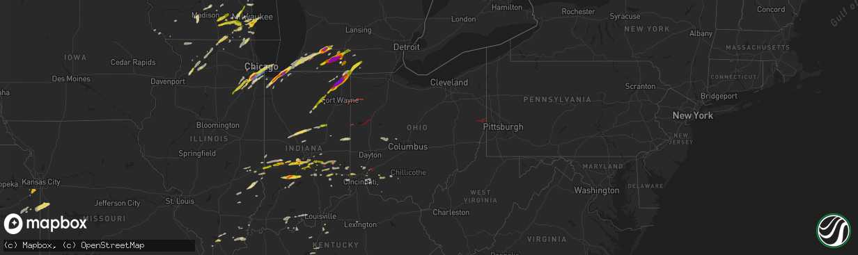
Hail Map in Ohio on May 7, 2024
The weather event in Ohio on May 7, 2024 includes Hail, Wind, and Tornado maps. 19 states and 876 cities were impacted and suffered possible damage. The total estimated number of properties impacted is 103.
Hail
Wind
Tornado
103
Estimated number of impacted properties by a 1.00" hail or larger0
Estimated number of impacted properties by a 1.75" hail or larger0
Estimated number of impacted properties by a 2.50" hail or largerStorm reports in Ohio
Ohio
| Date | Description |
|---|---|
| 05/07/20246:58 PM CDT | Large branches down; home insolation scattered. |
| 05/07/20246:51 PM CDT | Structural damage in macedon... Oh. Time estimated from radar. Possible tornado. |
| 05/07/20246:50 PM CDT | Ef2 tornado confirmed west of coldwater in mercer county ohio. Maximum winds of 120 mph. |
| 05/07/20246:45 PM CDT | Tree uprooted and branches down on sr49 and siegrist-jutte road. Time estimated from radar. Possible tornado. |
| 05/07/202412:20 PM CDT | Large tree and wires down near ridgeland place and montgomery road. |
| 05/07/202410:49 AM CDT | Multiple trees down... One of which causing damage to back porch of residence near intersection of rain rock road and rocky ford road. |
| 05/07/20248:21 AM CDT | Large tree branches thrown and several uprooted. Possible tornado. Time estimated. |
| 05/07/20248:21 AM CDT | Large tree branches thrown and several uprooted. Possible tornado. Time estimated. |
| 05/07/20242:12 AM CDT | Tree and power lines down. Time estimated from radar. |
| 05/07/20242:00 AM CDT | Tree down. Blocking both lanes of state route 522 in the 6700 block. Time estimated from radar. |
| 05/07/20241:54 AM CDT | Tree down blocking both lanes of county road 210. Time estimated from radar. |
| 05/07/202412:00 AM CDT | Radar confirmed tornado. Damage to trees and homes near county road 55. Time estimated on radar. |
| 05/07/202412:00 AM CDT | Damage to houses... Barns... And outbuildings. Possible tornado. |
| 05/06/202411:47 PM CDT | Wires down on heller drive. |
| 05/06/202411:27 PM CDT | House roof ripped off. Widespread trees/power lines down. Time estimated from tcmh tdwr and kpbz wsr-88d velocity data. |
| 05/06/202411:26 PM CDT | Significant wind damage with numerous trees down on vehicles in the neighborhood vicinity of township road 285. Area within about 3/4 mile radius has wind damage. Time |
| 05/06/202411:18 PM CDT | Nws storm survey team found an ef1 tornado with maximum gusts of 105mph that occurred early wednesday morning west of conesville. Additional details will be found in a |
| 05/06/202411:16 PM CDT | Several trees down in the franklin township area. |
| 05/06/202411:15 PM CDT | Major roof damage to house and downed trees. Garage destroyed. |
| 05/06/202411:14 PM CDT | Trees onto homes and garage destroyed. Possible tornado. |
| 05/06/202411:12 PM CDT | Multiple trees down. Time estimated by radar. |
| 05/06/202411:10 PM CDT | Downed power lines. |
| 05/06/202411:09 PM CDT | Corrects date for previous tstm wnd dmg report from 3 nnw frazeysburg. Possible tornado. New garage damaged. Time estimated from tcmh tdwr velocity signature. |
| 05/06/202411:03 PM CDT | Nws storm survey team found an ef1 tornado with maximum gusts of 100mph that occurred early wednesday morning north of frazeysburg. Additional details will be found in |
| 05/06/202411:00 PM CDT | Damage to barn and outbuilding in the 6800 block of licking valley road. Public report to nws pittsburgh relayed to nws wilmington. |
| 05/06/202410:59 PM CDT | Tree down along stoney road. |
| 05/06/202410:49 PM CDT | Nws storm survey confirms an ef0 tornado with maximum estimated wind speeds of 75 mph and a path length of 3.1 miles. Damage primarily to trees and outbuildings. |
| 05/06/20249:54 PM CDT | Report from mping: quarter |
| 05/06/20249:35 PM CDT | Tree fell into two houses. Time estimated from radar data. |
| 05/06/20249:29 PM CDT | Large tree snapped. Time estimated from radar. |
| 05/06/20249:27 PM CDT | Ef0 tornado confirmed west of clarksville in warren county ohio. Maximum winds of 80 mph. |
| 05/06/20249:27 PM CDT | Ef0 tornado confirmed north of blanchester in clinton county ohio. Maximum winds of 85 mph. |
| 05/06/20249:25 PM CDT | Numerous trees down near 92 irvin road near blanchester. Barn destroyed near the intersection of irvin road and route 133. |
| 05/06/20249:18 PM CDT | Large tree down... Damaging 2 houses. Time estimated from radar. |
| 05/06/20249:18 PM CDT | Ef0 tornado confirmed northeast of morrow in warren county ohio. Maximum winds of 80 mph. |
| 05/06/20249:16 PM CDT | Multiple trees and power poles down along mason morrow millgrove road. Time estimated from radar data. |
| 05/06/20249:15 PM CDT | Ef1 tornado confirmed near morrow in warren county ohio. Maximum winds of 95 mph. |
| 05/06/20249:14 PM CDT | Ef-0 tornado confirmed 2e lebanon in warren county ohio. Max winds of 65 mph. |
| 05/06/20249:13 PM CDT | Report from mping: quarter |
| 05/06/20249:13 PM CDT | Multiple trees and power lines down. Time estimated from radar data. |
| 05/06/20249:10 PM CDT | Ef-1 tornado confirmed 2ne south lebanon in warren county ohio. Max winds of 90 mph. |
| 05/06/20249:02 PM CDT | Multiple large trees damaged; outbuilding damage. Possible tor with cc dropout. |
| 05/06/20249:00 PM CDT | Several pine trees snapped. |
| 05/06/20248:57 PM CDT | Ef0 tornado confirmed in middletown in butler county ohio. Maximum winds of 80 mph. |
| 05/06/20248:56 PM CDT | Siding pulled from a metal building. Semi trailer rolled. Time estimated. |
| 05/06/20248:20 PM CDT | Ef1 tornado confirmed south-southeast of oxford... Ohio. Maximum winds of 110 mph. |
| 05/06/20248:17 PM CDT | Flying debris damaged a car. Time estimated. Possible tornado. |
| 05/06/20248:14 PM CDT | Approximately 50 trees downed in the pond run area of nile township. Time estimated. |
| 05/06/20248:13 PM CDT | Approximately 100 trees down in shawnee state forest per forest service manager. Time estimated. |
| 05/06/20247:56 PM CDT | Trained spotter observed a very brief tornado about 2 miles sse of belmore. A friend closer to the storm confirmed it visually on the ground for a few seconds. |
| 05/06/20247:54 PM CDT | A trained spotter reported a brief tornado touched down south of belmore... Oh at 8:54 pm edt may 7th. Videos confirm that a tornado did touch down in a field just east |
| 05/06/20247:44 PM CDT | Damage to multiple farm buildings. Possible tornado. |
| 05/06/20247:40 PM CDT | Numerous photos on facebook of a funnel cloud nearly on the ground between melrose and oakwood. Additional photos show the tornado on the ground near oakwood. Fairly ce |
| 05/06/20247:36 PM CDT | Photo on x/twitter between melrose and leipsic of a tornado on the ground. Time estimated by radar. |
| 05/06/20247:35 PM CDT | Corrects previous tstm wnd dmg report from 1 n greenville. Roof damage. Trees down on parkside drive. |
| 05/06/20247:31 PM CDT | Multiple trees down... Structural damage. Roofs destroyed. Possible tornado. |
| 05/06/20247:29 PM CDT | Small tree down on wagner avenue. Time estimated from radar data. |
| 05/06/20247:29 PM CDT | Tree blown down in front of house on south side of rhoades ave in greenville. |
| 05/06/20247:28 PM CDT | Damage to harmon field and press box is destroyed. Time estimated from radar. |
| 05/06/20247:28 PM CDT | Press box damaged at greenville high school football stadium. Time estimated from radar data. |
| 05/06/20247:24 PM CDT | Ef1 tornado confirmed in and near greenville in darke county ohio. Maximum winds of 110 mph. |
| 05/06/20247:20 PM CDT | Ef2 tornado confirmed west of new knoxville in mercer and auglaize counties in ohio. Maximum winds of 130 mph. |
| 05/06/20247:19 PM CDT | Mostly pea-sized hail... But a few stones as large as a quarter mixed in. |
| 05/06/20247:16 PM CDT | Emergency management sent drone footage which shows scoured dirt through a freshly plowed field along road 166 between road 191 and ohio 66. The track terminates near a |
| 05/06/20247:13 PM CDT | Report of tornado with visible soil lofted along highway 613 west of oakwood. |
| 05/06/20247:11 PM CDT | Several reports of funnel clouds and a touchdown were received from near latty east to south of melrose and west of oakwood. The most extensive damage occurred north of |
| 05/06/20247:09 PM CDT | Corrects time of previous tornado report from 2 w melrose. Additional review by emergency management and nws found damage near belmore... So the time and path length of |
| 05/06/20247:08 PM CDT | Van wert county ema relayed a photo of a tornado. Further investigation confirmed this damaged the house of a relative. Time estimated. |
| 05/06/20247:06 PM CDT | Small to medium limbs downed. |
All States Impacted by Hail Map on May 7, 2024
Cities Impacted by Hail Map on May 7, 2024
- Alma, AR
- Mulberry, AR
- Ozark, AR
- Melvin, TX
- Mount Washington, KY
- Prophetstown, IL
- Milledgeville, IL
- Polo, IL
- Sterling, IL
- Rock Falls, IL
- Lyndon, IL
- Dixon, IL
- Baileyville, IL
- Oregon, IL
- Mount Morris, IL
- Leaf River, IL
- Kinsman, IL
- Verona, IL
- Morris, IL
- Mazon, IL
- Winnebago, IL
- Byron, IL
- Channahon, IL
- Wilmington, IL
- Coal City, IL
- Minooka, IL
- Joliet, IL
- Rockford, IL
- Elwood, IL
- Shorewood, IL
- Forreston, IL
- Alsip, IL
- Homer Glen, IL
- Franklin Grove, IL
- Machesney Park, IL
- Roscoe, IL
- Loves Park, IL
- Clinton, WI
- Plainfield, IL
- Chicago, IL
- New Lenox, IL
- Manhattan, IL
- Mokena, IL
- Lockport, IL
- Evergreen Park, IL
- Orland Park, IL
- Lemont, IL
- Waukesha, WI
- Wales, WI
- Delafield, WI
- Oak Lawn, IL
- Caledonia, IL
- South Beloit, IL
- Poplar Grove, IL
- Tinley Park, IL
- Belvidere, IL
- Garden Prairie, IL
- Janesville, WI
- Romeoville, IL
- Beloit, WI
- Dousman, WI
- Capron, IL
- Harvard, IL
- Crest Hill, IL
- Morehead, KY
- Oak Forest, IL
- Palos Heights, IL
- Palos Park, IL
- Frankfort, IL
- Crestwood, IL
- Midlothian, IL
- Whitewater, WI
- Avalon, WI
- Delavan, WI
- Sharon, WI
- Darien, WI
- Pewaukee, WI
- Palos Hills, IL
- Worth, IL
- Chicago Ridge, IL
- Robbins, IL
- Blue Island, IL
- Riverdale, IL
- Verona, WI
- Owingsville, KY
- Salt Lick, KY
- Hickory Hills, IL
- Lyons, IL
- La Grange, IL
- Brookfield, IL
- Sussex, WI
- Hartland, WI
- Belleville, WI
- Walworth, WI
- Mount Horeb, WI
- Bridgeview, IL
- Willow Springs, IL
- Marengo, IL
- Cross Plains, WI
- Williams Bay, WI
- Cedar Lake, IN
- Elkhorn, WI
- Lake Geneva, WI
- Fontana, WI
- Hometown, IL
- La Grange Park, IL
- Burbank, IL
- Hobart, IN
- Portage, IN
- Merrillville, IN
- Menomonee Falls, WI
- Colgate, WI
- Valparaiso, IN
- Germantown, WI
- Richfield, WI
- Chesterton, IN
- Eagle, WI
- Martinsville, IL
- Panther, WV
- Casey, IL
- Burlington, WI
- Crown Point, IN
- Mohawk, WV
- Marshall, IL
- East Troy, WI
- Rochester, WI
- Waterford, WI
- Springfield, WI
- Hebron, IL
- Beverly Shores, IN
- Michigan City, IN
- Markham, IL
- Westville, IN
- Mukwonago, WI
- Mchenry, IL
- Iaeger, WV
- Ringwood, IL
- Spring Grove, IL
- Dennison, IL
- West Terre Haute, IN
- Franklin, WI
- Ingleside, IL
- Fox Lake, IL
- New Buffalo, MI
- Trevor, WI
- Salem, WI
- Round Lake, IL
- Antioch, IL
- Lake Villa, IL
- Franksville, WI
- Muskego, WI
- Oak Creek, WI
- Caledonia, WI
- Terre Haute, IN
- Union Pier, MI
- Dobson, NC
- Racine, WI
- South Milwaukee, WI
- Cudahy, WI
- Lakeside, MI
- Jesup, IA
- Clinton, IN
- La Porte, IN
- Bridgman, MI
- Baroda, MI
- Buchanan, MI
- Sawyer, MI
- Kenosha, WI
- Rutherfordton, NC
- Bristol, WI
- Gary, IN
- Sturtevant, WI
- Three Oaks, MI
- Downers Grove, IL
- Lisle, IL
- Woodridge, IL
- Union Grove, WI
- Berrien Springs, MI
- Brazil, IN
- Independence, IA
- Homewood, IL
- Country Club Hills, IL
- Harvey, IL
- Matteson, IL
- Hazel Crest, IL
- Flossmoor, IL
- New Troy, MI
- Staunton, IN
- Turtle Lake, WI
- Almena, WI
- Hillsdale, IN
- Darlington, IN
- Berrien Center, MI
- Eau Claire, MI
- Charleston, IL
- Reidsville, NC
- Harmony, IN
- Reelsville, IN
- Sodus, MI
- White Pigeon, MI
- Constantine, MI
- Dowagiac, MI
- Westfield, IL
- South Holland, IL
- Clarks Hill, IN
- Colfax, IN
- Frankfort, IN
- Dolton, IL
- Cumberland, WI
- Comstock, WI
- Calumet City, IL
- Knightsville, IN
- Saint Joseph, MI
- Benton Harbor, MI
- Union, MI
- Edwardsburg, MI
- Winthrop, IA
- Ferguson, NC
- Crawfordsville, IN
- Greencastle, IN
- Jones, MI
- Millers Creek, NC
- Wilkesboro, NC
- Decatur, MI
- Hartford, MI
- Lenoir, NC
- Boomer, NC
- Colfax, WI
- Wheeler, WI
- New Berlin, WI
- Michigantown, IN
- Vandalia, MI
- Cassopolis, MI
- Cloverdale, IN
- Osseo, WI
- Three Rivers, MI
- Mendon, MI
- Fillmore, IN
- North Wilkesboro, NC
- Hebron, IN
- Taylorsville, NC
- Highland, IN
- Hammond, IN
- Griffith, IN
- Masonville, IA
- Centreville, MI
- Tipton, IN
- Kempton, IN
- Forest, IN
- Paris, IL
- Carbon, IN
- Rosedale, IN
- Paw Paw, MI
- Lawton, MI
- Lake Station, IN
- Jamestown, IN
- Russiaville, IN
- Leonidas, MI
- Fulton, MI
- Putnamville, IN
- Coatesville, IN
- Colon, MI
- Athens, MI
- Sherwood, MI
- Union City, MI
- Kalamazoo, MI
- Jacksonville, NC
- Dundee, IA
- Whitestown, IN
- Lebanon, IN
- Mattawan, MI
- Calmar, IA
- Peru, IN
- Manchester, IA
- Stilesville, IN
- Sharpsville, IN
- Burlington, MI
- Portage, MI
- Tekonsha, MI
- North Manchester, IN
- Laketon, IN
- Camp Lejeune, NC
- Roann, IN
- Wabash, IN
- Denver, IN
- Westfield, IN
- Sheridan, IN
- Decorah, IA
- Tomah, WI
- Warrens, WI
- West Union, IL
- Harbert, MI
- Windfall, IN
- Greentown, IN
- Farmersburg, IN
- Shelburn, IN
- Elkin, NC
- Angola, IN
- Coldwater, MI
- Greenwood, IN
- Indianapolis, IN
- Mooresville, IN
- Ceresco, MI
- East Leroy, MI
- Liberty Mills, IN
- Claypool, IN
- South Whitley, IN
- State Road, NC
- Climax, MI
- Scotts, MI
- Galesburg, MI
- Marshall, MI
- Vicksburg, MI
- Pimento, IN
- Lewis, IN
- Martinsville, IN
- Stevensville, MI
- West Newton, IN
- Camby, IN
- Columbia City, IN
- Pierceton, IN
- Larwill, IN
- Jonesboro, IN
- Fairmount, IN
- Fairbanks, IN
- Whitehall, MI
- Montague, MI
- Battle Creek, MI
- Urbana, IN
- Lagro, IN
- Greeley, IA
- Edgewood, IA
- Churubusco, IN
- Albion, IN
- Huntington, IN
- Morgantown, IN
- Clay City, IN
- Trafalgar, IN
- Homer, MI
- Earlville, IA
- Dyersville, IA
- New Vienna, IA
- Poland, IN
- Cassville, WI
- Monrovia, IN
- Marion, IN
- Gas City, IN
- Upland, IN
- Avilla, IN
- Kendallville, IN
- Corunna, IN
- Waterloo, IN
- Hudson, IN
- Ashley, IN
- Siloam, NC
- Pinnacle, NC
- Watervliet, MI
- Laotto, IN
- Garrett, IN
- Albion, MI
- Franklin, IN
- Bargersville, IN
- Quincy, IN
- Beech Grove, IN
- Clayton, IN
- Cory, IN
- Coal City, IN
- Bowling Green, IN
- Durango, IA
- Dubuque, IA
- Peosta, IA
- Patricksburg, IN
- Plainfield, IN
- Shelbyville, IN
- Edinburgh, IN
- King, NC
- Pilot Mountain, NC
- Ronda, NC
- Silver Lake, IN
- Linden, WI
- Livingston, WI
- Montfort, WI
- Avon, IN
- Cascade, VA
- Axton, VA
- Danville, VA
- Brooklyn, IN
- Rice Lake, WI
- Stony Point, NC
- Ellettsville, IN
- Bloomington, IN
- Gosport, IN
- Sherrill, IA
- Spencer, IN
- Greenfield, IN
- Auburn, IN
- Dodgeville, WI
- Pleasant Lake, IN
- Hamilton, IN
- Wisconsin Dells, WI
- Guttenberg, IA
- Holy Cross, IA
- Manilla, IN
- Waldron, IN
- Germanton, NC
- Walnut Cove, NC
- New Market, AL
- Muncie, IN
- Montgomery, MI
- Fremont, IN
- Hazel Green, AL
- Warsaw, IN
- Whiteland, IN
- Milroy, IN
- Saint Paul, IN
- Schoolcraft, MI
- Cuba City, WI
- Oxford, WI
- Reading, MI
- Camden, MI
- Eden, NC
- Ararat, NC
- Boonville, NC
- Elora, TN
- Hillsdale, MI
- Needham, IN
- Homer, IN
- Boggstown, IN
- Fairland, IN
- Rushville, IN
- Richland, MI
- Augusta, MI
- Flintville, TN
- Edon, OH
- Osseo, MI
- North Adams, MI
- Jerome, MI
- Saint Meinrad, IN
- Ferdinand, IN
- Bristow, IN
- Evanston, IN
- Winchester, IN
- Farmland, IN
- Ruffin, NC
- Glenwood, IN
- Birdseye, IN
- Connersville, IN
- Wolcottville, IN
- Union City, IN
- Camp Douglas, WI
- Stockton, IL
- Laurel, IN
- Black River Falls, WI
- Rome City, IN
- Topeka, IN
- Nineveh, IN
- Greensburg, IN
- Coldwater, OH
- Fort Recovery, OH
- Dry Fork, VA
- Monroeville, IN
- Payne, OH
- Deforest, WI
- Waunakee, WI
- Madison, WI
- Lena, IL
- Lagrange, IN
- Flat Rock, IN
- Union City, OH
- Wawaka, IN
- Latty, OH
- Paulding, OH
- Haviland, OH
- Oakwood, OH
- Melrose, OH
- New Bremen, OH
- Saint Marys, OH
- New Knoxville, OH
- Wapakoneta, OH
- Sun Prairie, WI
- Windsor, WI
- Bronson, MI
- English, IN
- Stinesville, IN
- Metamora, IN
- Liberty, IN
- New Palestine, IN
- Westport, IN
- Fort Atkinson, WI
- Jefferson, WI
- Brookville, IN
- Milton, WI
- Edgerton, WI
- Oldenburg, IN
- Louisville, IL
- Cambridge, WI
- Depauw, IN
- Milltown, IN
- Leavenworth, IN
- Unionville, IN
- Columbus, IN
- Rio, WI
- Osgood, IN
- Sulphur, IN
- Johnson Creek, WI
- Helenville, WI
- Watertown, WI
- Sullivan, WI
- Deerfield, WI
- Columbus, WI
- Marshall, WI
- Waterloo, WI
- Ramsey, IN
- Oxford, OH
- Bath, IN
- Cedar Grove, IN
- Ingraham, IL
- Noble, IL
- Clay City, IL
- Palmyra, WI
- West Harrison, IN
- Okeana, OH
- Pittsford, MI
- Sunman, IN
- Batesville, IN
- Lake Mills, WI
- Waldron, MI
- North Prairie, WI
- Reeseville, WI
- Adams, WI
- Menlo, GA
- Concord, MI
- Hanover, MI
- Hope, IN
- Newton, IL
- Corydon, IN
- Big Bend, WI
- Hamilton, OH
- Trion, GA
- Summerville, GA
- Sainte Marie, IL
- Willow Hill, IL
- Oblong, IL
- Robinson, IL
- West Liberty, IL
- La Fayette, GA
- Milwaukee, WI
- Hutsonville, IL
- Sullivan, IN
- Stoy, IL
- West York, IL
- Guilford, IN
- Lawrenceburg, IN
- Elm Grove, WI
- Brookfield, WI
- Middletown, OH
- Fairfield, OH
- West Chester, OH
- Cable, OH
- Urbana, OH
- Trenton, OH
- Morrow, OH
- Lebanon, OH
- Oregonia, OH
- Cedarburg, WI
- Grafton, WI
- Greendale, WI
- Hales Corners, WI
- Cincinnati, OH
- Monroe, OH
- Woodstock, OH
- Mechanicsburg, OH
- Holton, IN
- Harrison, OH
- Kansasville, WI
- Cleves, OH
- South Lebanon, OH
- Clarksville, OH
- Roaring River, NC
- Loveland, OH
- Maineville, OH
- Butlerville, IN
- Mason, OH
- Jasonville, IN
- Ikes Fork, WV
- Lawrenceville, IL
- Irwin, OH
- Milford Center, OH
- Plain City, OH
- Marysville, OH
- Freedom, IN
- Worthington, IN
- Milan, IN
- Saukville, WI
- West Bend, WI
- Paragon, IN
- Riley, IN
- Centerpoint, IN
- Goshen, OH
- Clifford, IN
- Milford, OH
- Pleasant Plain, OH
- Solsberry, IN
- Bloomfield, IN
- Hartsville, IN
- Aurora, IN
- Moores Hill, IN
- Midland, OH
- Blanchester, OH
- Springville, IN
- Lynchburg, OH
- Martinsville, OH
- Jackson, MO
- Batavia, OH
- Fayetteville, OH
- Miamiville, OH
- Nashville, IN
- Makanda, IL
- Hillsboro, OH
- Amelia, OH
- Goreville, IL
- Marion, IL
- New Vienna, OH
- Williamsburg, OH
- Mount Orab, OH
- Bedford, IN
- Carbondale, IL
- Heltonville, IN
- Bridgeport, IL
- Norman, IN
- Creal Springs, IL
- Greenfield, OH
- Bainbridge, OH
- Seymour, IN
- Brownstown, IN
- Freetown, IN
- Pittsburg, IL
- Norris City, IL
- Waverly, OH
- Peebles, OH
- Stonefort, IL
- Carrier Mills, IL
- Mount Vernon, IN
- Chillicothe, OH
- Thompsonville, IL
- New Burnside, IL
- Harrisburg, IL
- Galatia, IL
- Junction, IL
- Equality, IL
- Ozark, IL
- Cairo, IL
- Hammondsville, OH
- Irondale, OH
- New Cumberland, WV
- Toronto, OH
- Chester, WV
- Georgetown, PA
- Weiner, AR
- Shawneetown, IL
- Wellsville, OH
- Eddyville, IL
- Amagon, AR
- Newport, AR
- Herod, IL
- Royal, AR
- Williamsville, MO
- Bonnerdale, AR
- Mound City, IL
- Beaver, PA
- Beaver Falls, PA
- McClure, IL
- Jonesboro, IL
- Jonesboro, AR
- Wappapello, MO
- Greenville, MO
- New Brighton, PA
- Mountain Pine, AR
- Hot Springs National Park, AR
- Sturgis, KY
- Anna, IL
- Pearcy, AR
- Buncombe, IL
- Morganfield, KY
- Advance, MO
- Mounds, IL
- Lewisport, KY
- Russellville, OH
- McGee, MO
- Barlow, KY
- La Center, KY
- Kevil, KY
- Tell City, IN
- Oran, MO
- Metropolis, IL
- Grand Chain, IL
- Stout, OH
- Bismarck, AR
- Hot Springs Village, AR
- Lonsdale, AR
- Burna, KY
- Olmsted, IL
- Golconda, IL
- Villa Ridge, IL
- Angola, NY
- Cannelton, IN
- Benton, AR
- Eden, NY
- Salem, KY
- Marion, KY
- Derby, NY
- Hamburg, NY
- Rome, IN
- Stephensport, KY
- Union Star, KY
- Hardinsburg, KY
- Elizabeth, IN
- Webster, KY
- Alexander, AR
- Penfield, NY
- Fairport, NY
- Macedon, NY
- Paron, AR
- Bryant, AR
- Little Rock, AR
- North Little Rock, AR
- Scott, AR
- Bardstown, KY
- Mabelvale, AR
- Clermont, KY
- Shepherdsville, KY
- Coxs Creek, KY
- Bauxite, AR
- Sherwood, AR
- Brookport, IL
- Cecilia, KY
- Elizabethtown, KY
- Boston, KY
- England, AR
- Rineyville, KY
- Hensley, AR
- Lexington, KY
- Lonoke, AR
- Keo, AR
- Bardwell, KY
- Wickliffe, KY
- Charleston, MO
- Orbisonia, PA
- Shade Gap, PA
- Carlisle, AR
- Humnoke, AR
- Blairs Mills, PA
- Cunningham, KY
- Redfield, AR
- Stuttgart, AR
- Hazen, AR
- Puryear, TN
- Hazel, KY
- Buchanan, TN
- West Paducah, KY
- Sheridan, AR
- Tucker, AR
- Ulm, AR
- New Concord, KY
- Murray, KY
- Cub Run, KY
- Munfordville, KY
- Bonnieville, KY
- Sonora, KY
- Upton, KY
- Magnolia, KY
- Hardin, KY
- Benton, KY
- Kirksey, KY
- Wabbaseka, AR
- Roe, AR
- De Valls Bluff, AR
- Humphrey, AR
- Dover, TN
- Mayfield, KY
- Paducah, KY
- Clarendon, AR
- Brinkley, AR
- Holly Grove, AR
- Almo, KY
- Hodgenville, KY
- Webster Springs, WV
- Big Rock, TN
- Indian Mound, TN
- Dexter, KY
- Cadiz, KY
- Bumpus Mills, TN
- Clarksville, TN
- Trenton, KY
- Woodlawn, TN
- Fort Campbell, KY
- La Fayette, KY
- Allensville, KY
- Guthrie, KY
- Herndon, KY
- Martin, TN
- Fountain Run, KY
- Scottsville, KY
- Oak Grove, KY
- Moro, AR
- Marianna, AR
- Dresden, TN
- Olmstead, KY
- Adairville, KY
- Aubrey, AR
- Russellville, KY
- Wingo, KY
- Adams, TN
- Cedar Hill, TN
- Springfield, TN
- Elkton, KY
- Franklin, KY
- Lebanon Junction, KY
- Greenbrier, TN
- Portageville, MO
- Orlinda, TN
- Cross Plains, TN
- Portland, TN
- Greeley, KS
- Parker, KS
- Lane, KS
- Garnett, KS
- Palmersville, TN
- Farmington, KY
- Paola, KS
- La Cygne, KS
- White House, TN
- Adolphus, KY
- Westmoreland, TN
- Osawatomie, KS
- Bethpage, TN
- Fontana, KS
- Hughes, AR
- Gallatin, TN
- Tiptonville, TN
- New Madrid, MO
- Louisburg, KS
- Drexel, MO
- Adrian, MO
- Amsterdam, MO
- Lilbourn, MO
- Marston, MO
- Hickman, KY
- Hendersonville, TN
- Cottontown, TN
- Sedalia, KY
- Burkesville, KY
- Lafayette, TN
- Albany, KY
- Scalf, KY
- Flat Lick, KY
- Walker, KY
- Harrisonville, MO
- Archie, MO
- Union City, TN
- Troy, TN
- Hornbeak, TN
- Manchester, KY
- Olathe, KS
- Garden City, MO
- Freeman, MO
- Overland Park, KS
- Hartsville, TN
- Ashland City, TN
- Gardner, KS
- Edgerton, KS
- Spring Hill, KS
- Elkhart, IN
- Borden, IN
- Memphis, IN
- Sellersburg, IN


