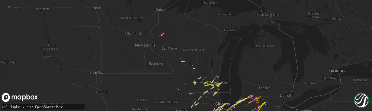
Hail Map in Wisconsin on May 7, 2024
The weather event in Wisconsin on May 7, 2024 includes Hail, Wind, and Tornado maps. 19 states and 876 cities were impacted and suffered possible damage. The total estimated number of properties impacted is 47,425.
Hail
Wind
Tornado
47,425
Estimated number of impacted properties by a 1.00" hail or larger231
Estimated number of impacted properties by a 1.75" hail or larger0
Estimated number of impacted properties by a 2.50" hail or largerStorm reports in Wisconsin
Wisconsin
| Date | Description |
|---|---|
| 05/07/20246:48 PM CDT | Dime to quarter size hail. |
| 05/07/20246:47 PM CDT | Report of 2 trees down in town of oxford and 1 tree down in village of westfield. Time estimated from radar. |
| 05/07/20246:33 PM CDT | Some quarter size... Most nickel size. Also reported by emergency manager. |
| 05/07/20245:30 PM CDT | Variable hail sizes up to 1 inch in diameter. Stripped leaves and branches off trees. |
| 05/07/20244:22 PM CDT | A local report indicates 1.75 inch wind near 3 SE Cumberland |
| 05/07/20243:42 PM CDT | Report from mping: quarter |
| 05/07/20243:38 PM CDT | Report from mping: quarter |
| 05/07/20243:36 PM CDT | Report from mping: quarter |
| 05/07/20243:32 PM CDT | Report from mping: half dollar |
| 05/07/20243:32 PM CDT | Report |
| 05/07/20243:31 PM CDT | Picture with measurement shown on wisn 12. |
| 05/07/20243:30 PM CDT | Report from mping: quarter |
| 05/07/20243:30 PM CDT | Photos of measured 1in hail from spotter on facebook. |
| 05/07/20243:30 PM CDT | Photos of hail provided via email. |
| 05/07/20243:30 PM CDT | A local report indicates 1.00 inch wind near 1 S South Milwaukee |
| 05/07/20242:38 PM CDT | Photos and video relayed by amateur radio showing snapped trees and tree limbs near prestwick drive in the geneva national golf community. Time estimated via radar. |
| 05/07/20242:24 PM CDT | A local report indicates 1.00 inch wind near Sussex |
| 05/07/20242:24 PM CDT | Semi rolled over near intersection of hwy 67 and us 14. Power lines down in area of walworth and fontana. Time estimated from radar. |
| 05/07/20242:23 PM CDT | Large tree branch down and leaning power pole near intersection of hwy 67 and county rd b. |
| 05/07/20242:21 PM CDT | Nws survey team confirmed an ef-0 with 80 mph winds across southern walworth county from east of sharon to west of walworth. |
| 05/07/20242:19 PM CDT | Nws storm survey confirmed a short lived ef-1 with 90 mph winds south of darien. |
| 05/07/20242:18 PM CDT | Report from mping: quarter |
| 05/06/20249:09 PM CDT | Report from mping: quarter |
| 05/06/20248:58 PM CDT | Several reports around town of trees... Limbs and power lines down. Time est by radar. |
| 05/06/20248:55 PM CDT | Multiple reports around town of trees... Limbs and power lines down. Time est by radar. |
| 05/06/20248:45 PM CDT | Report from mping: quarter |
| 05/06/20248:45 PM CDT | Tree down at the knob road and warren road intersection. Time estimated by radar. |
| 05/06/20248:39 PM CDT | Tree downed... Damaging a vehicle. |
| 05/06/20248:38 PM CDT | Public report of nickel to quarter size hail in mukwonago. Time estimated via radar. |
| 05/06/20248:35 PM CDT | Time estimated by radar. Report of tree down along sheridan springs road. |
| 05/06/20248:29 PM CDT | Multiple reports of trees and power lines down between southern delavan area and geneva area. No specific address at this time. Time estimated from radar. |
| 05/06/20248:25 PM CDT | Time estimated by radar. Trees damage reported across delavan. |
| 05/06/20248:25 PM CDT | Public report of broken tree limbs near the community of avalon. |
| 05/06/20247:41 PM CDT | Report of wires down at meadow lane/county rd vv. Time estimated by radar. |
| 05/06/20247:41 PM CDT | Report of wires down. Time estimated by radar. |
| 05/06/20247:00 PM CDT | Report from mping: quarter |
All States Impacted by Hail Map on May 7, 2024
Cities Impacted by Hail Map on May 7, 2024
- Alma, AR
- Mulberry, AR
- Ozark, AR
- Melvin, TX
- Mount Washington, KY
- Prophetstown, IL
- Milledgeville, IL
- Polo, IL
- Sterling, IL
- Rock Falls, IL
- Lyndon, IL
- Dixon, IL
- Baileyville, IL
- Oregon, IL
- Mount Morris, IL
- Leaf River, IL
- Kinsman, IL
- Verona, IL
- Morris, IL
- Mazon, IL
- Winnebago, IL
- Byron, IL
- Channahon, IL
- Wilmington, IL
- Coal City, IL
- Minooka, IL
- Joliet, IL
- Rockford, IL
- Elwood, IL
- Shorewood, IL
- Forreston, IL
- Alsip, IL
- Homer Glen, IL
- Franklin Grove, IL
- Machesney Park, IL
- Roscoe, IL
- Loves Park, IL
- Clinton, WI
- Plainfield, IL
- Chicago, IL
- New Lenox, IL
- Manhattan, IL
- Mokena, IL
- Lockport, IL
- Evergreen Park, IL
- Orland Park, IL
- Lemont, IL
- Waukesha, WI
- Wales, WI
- Delafield, WI
- Oak Lawn, IL
- Caledonia, IL
- South Beloit, IL
- Poplar Grove, IL
- Tinley Park, IL
- Belvidere, IL
- Garden Prairie, IL
- Janesville, WI
- Romeoville, IL
- Beloit, WI
- Dousman, WI
- Capron, IL
- Harvard, IL
- Crest Hill, IL
- Morehead, KY
- Oak Forest, IL
- Palos Heights, IL
- Palos Park, IL
- Frankfort, IL
- Crestwood, IL
- Midlothian, IL
- Whitewater, WI
- Avalon, WI
- Delavan, WI
- Sharon, WI
- Darien, WI
- Pewaukee, WI
- Palos Hills, IL
- Worth, IL
- Chicago Ridge, IL
- Robbins, IL
- Blue Island, IL
- Riverdale, IL
- Verona, WI
- Owingsville, KY
- Salt Lick, KY
- Hickory Hills, IL
- Lyons, IL
- La Grange, IL
- Brookfield, IL
- Sussex, WI
- Hartland, WI
- Belleville, WI
- Walworth, WI
- Mount Horeb, WI
- Bridgeview, IL
- Willow Springs, IL
- Marengo, IL
- Cross Plains, WI
- Williams Bay, WI
- Cedar Lake, IN
- Elkhorn, WI
- Lake Geneva, WI
- Fontana, WI
- Hometown, IL
- La Grange Park, IL
- Burbank, IL
- Hobart, IN
- Portage, IN
- Merrillville, IN
- Menomonee Falls, WI
- Colgate, WI
- Valparaiso, IN
- Germantown, WI
- Richfield, WI
- Chesterton, IN
- Eagle, WI
- Martinsville, IL
- Panther, WV
- Casey, IL
- Burlington, WI
- Crown Point, IN
- Mohawk, WV
- Marshall, IL
- East Troy, WI
- Rochester, WI
- Waterford, WI
- Springfield, WI
- Hebron, IL
- Beverly Shores, IN
- Michigan City, IN
- Markham, IL
- Westville, IN
- Mukwonago, WI
- Mchenry, IL
- Iaeger, WV
- Ringwood, IL
- Spring Grove, IL
- Dennison, IL
- West Terre Haute, IN
- Franklin, WI
- Ingleside, IL
- Fox Lake, IL
- New Buffalo, MI
- Trevor, WI
- Salem, WI
- Round Lake, IL
- Antioch, IL
- Lake Villa, IL
- Franksville, WI
- Muskego, WI
- Oak Creek, WI
- Caledonia, WI
- Terre Haute, IN
- Union Pier, MI
- Dobson, NC
- Racine, WI
- South Milwaukee, WI
- Cudahy, WI
- Lakeside, MI
- Jesup, IA
- Clinton, IN
- La Porte, IN
- Bridgman, MI
- Baroda, MI
- Buchanan, MI
- Sawyer, MI
- Kenosha, WI
- Rutherfordton, NC
- Bristol, WI
- Gary, IN
- Sturtevant, WI
- Three Oaks, MI
- Downers Grove, IL
- Lisle, IL
- Woodridge, IL
- Union Grove, WI
- Berrien Springs, MI
- Brazil, IN
- Independence, IA
- Homewood, IL
- Country Club Hills, IL
- Harvey, IL
- Matteson, IL
- Hazel Crest, IL
- Flossmoor, IL
- New Troy, MI
- Staunton, IN
- Turtle Lake, WI
- Almena, WI
- Hillsdale, IN
- Darlington, IN
- Berrien Center, MI
- Eau Claire, MI
- Charleston, IL
- Reidsville, NC
- Harmony, IN
- Reelsville, IN
- Sodus, MI
- White Pigeon, MI
- Constantine, MI
- Dowagiac, MI
- Westfield, IL
- South Holland, IL
- Clarks Hill, IN
- Colfax, IN
- Frankfort, IN
- Dolton, IL
- Cumberland, WI
- Comstock, WI
- Calumet City, IL
- Knightsville, IN
- Saint Joseph, MI
- Benton Harbor, MI
- Union, MI
- Edwardsburg, MI
- Winthrop, IA
- Ferguson, NC
- Crawfordsville, IN
- Greencastle, IN
- Jones, MI
- Millers Creek, NC
- Wilkesboro, NC
- Decatur, MI
- Hartford, MI
- Lenoir, NC
- Boomer, NC
- Colfax, WI
- Wheeler, WI
- New Berlin, WI
- Michigantown, IN
- Vandalia, MI
- Cassopolis, MI
- Cloverdale, IN
- Osseo, WI
- Three Rivers, MI
- Mendon, MI
- Fillmore, IN
- North Wilkesboro, NC
- Hebron, IN
- Taylorsville, NC
- Highland, IN
- Hammond, IN
- Griffith, IN
- Masonville, IA
- Centreville, MI
- Tipton, IN
- Kempton, IN
- Forest, IN
- Paris, IL
- Carbon, IN
- Rosedale, IN
- Paw Paw, MI
- Lawton, MI
- Lake Station, IN
- Jamestown, IN
- Russiaville, IN
- Leonidas, MI
- Fulton, MI
- Putnamville, IN
- Coatesville, IN
- Colon, MI
- Athens, MI
- Sherwood, MI
- Union City, MI
- Kalamazoo, MI
- Jacksonville, NC
- Dundee, IA
- Whitestown, IN
- Lebanon, IN
- Mattawan, MI
- Calmar, IA
- Peru, IN
- Manchester, IA
- Stilesville, IN
- Sharpsville, IN
- Burlington, MI
- Portage, MI
- Tekonsha, MI
- North Manchester, IN
- Laketon, IN
- Camp Lejeune, NC
- Roann, IN
- Wabash, IN
- Denver, IN
- Westfield, IN
- Sheridan, IN
- Decorah, IA
- Tomah, WI
- Warrens, WI
- West Union, IL
- Harbert, MI
- Windfall, IN
- Greentown, IN
- Farmersburg, IN
- Shelburn, IN
- Elkin, NC
- Angola, IN
- Coldwater, MI
- Greenwood, IN
- Indianapolis, IN
- Mooresville, IN
- Ceresco, MI
- East Leroy, MI
- Liberty Mills, IN
- Claypool, IN
- South Whitley, IN
- State Road, NC
- Climax, MI
- Scotts, MI
- Galesburg, MI
- Marshall, MI
- Vicksburg, MI
- Pimento, IN
- Lewis, IN
- Martinsville, IN
- Stevensville, MI
- West Newton, IN
- Camby, IN
- Columbia City, IN
- Pierceton, IN
- Larwill, IN
- Jonesboro, IN
- Fairmount, IN
- Fairbanks, IN
- Whitehall, MI
- Montague, MI
- Battle Creek, MI
- Urbana, IN
- Lagro, IN
- Greeley, IA
- Edgewood, IA
- Churubusco, IN
- Albion, IN
- Huntington, IN
- Morgantown, IN
- Clay City, IN
- Trafalgar, IN
- Homer, MI
- Earlville, IA
- Dyersville, IA
- New Vienna, IA
- Poland, IN
- Cassville, WI
- Monrovia, IN
- Marion, IN
- Gas City, IN
- Upland, IN
- Avilla, IN
- Kendallville, IN
- Corunna, IN
- Waterloo, IN
- Hudson, IN
- Ashley, IN
- Siloam, NC
- Pinnacle, NC
- Watervliet, MI
- Laotto, IN
- Garrett, IN
- Albion, MI
- Franklin, IN
- Bargersville, IN
- Quincy, IN
- Beech Grove, IN
- Clayton, IN
- Cory, IN
- Coal City, IN
- Bowling Green, IN
- Durango, IA
- Dubuque, IA
- Peosta, IA
- Patricksburg, IN
- Plainfield, IN
- Shelbyville, IN
- Edinburgh, IN
- King, NC
- Pilot Mountain, NC
- Ronda, NC
- Silver Lake, IN
- Linden, WI
- Livingston, WI
- Montfort, WI
- Avon, IN
- Cascade, VA
- Axton, VA
- Danville, VA
- Brooklyn, IN
- Rice Lake, WI
- Stony Point, NC
- Ellettsville, IN
- Bloomington, IN
- Gosport, IN
- Sherrill, IA
- Spencer, IN
- Greenfield, IN
- Auburn, IN
- Dodgeville, WI
- Pleasant Lake, IN
- Hamilton, IN
- Wisconsin Dells, WI
- Guttenberg, IA
- Holy Cross, IA
- Manilla, IN
- Waldron, IN
- Germanton, NC
- Walnut Cove, NC
- New Market, AL
- Muncie, IN
- Montgomery, MI
- Fremont, IN
- Hazel Green, AL
- Warsaw, IN
- Whiteland, IN
- Milroy, IN
- Saint Paul, IN
- Schoolcraft, MI
- Cuba City, WI
- Oxford, WI
- Reading, MI
- Camden, MI
- Eden, NC
- Ararat, NC
- Boonville, NC
- Elora, TN
- Hillsdale, MI
- Needham, IN
- Homer, IN
- Boggstown, IN
- Fairland, IN
- Rushville, IN
- Richland, MI
- Augusta, MI
- Flintville, TN
- Edon, OH
- Osseo, MI
- North Adams, MI
- Jerome, MI
- Saint Meinrad, IN
- Ferdinand, IN
- Bristow, IN
- Evanston, IN
- Winchester, IN
- Farmland, IN
- Ruffin, NC
- Glenwood, IN
- Birdseye, IN
- Connersville, IN
- Wolcottville, IN
- Union City, IN
- Camp Douglas, WI
- Stockton, IL
- Laurel, IN
- Black River Falls, WI
- Rome City, IN
- Topeka, IN
- Nineveh, IN
- Greensburg, IN
- Coldwater, OH
- Fort Recovery, OH
- Dry Fork, VA
- Monroeville, IN
- Payne, OH
- Deforest, WI
- Waunakee, WI
- Madison, WI
- Lena, IL
- Lagrange, IN
- Flat Rock, IN
- Union City, OH
- Wawaka, IN
- Latty, OH
- Paulding, OH
- Haviland, OH
- Oakwood, OH
- Melrose, OH
- New Bremen, OH
- Saint Marys, OH
- New Knoxville, OH
- Wapakoneta, OH
- Sun Prairie, WI
- Windsor, WI
- Bronson, MI
- English, IN
- Stinesville, IN
- Metamora, IN
- Liberty, IN
- New Palestine, IN
- Westport, IN
- Fort Atkinson, WI
- Jefferson, WI
- Brookville, IN
- Milton, WI
- Edgerton, WI
- Oldenburg, IN
- Louisville, IL
- Cambridge, WI
- Depauw, IN
- Milltown, IN
- Leavenworth, IN
- Unionville, IN
- Columbus, IN
- Rio, WI
- Osgood, IN
- Sulphur, IN
- Johnson Creek, WI
- Helenville, WI
- Watertown, WI
- Sullivan, WI
- Deerfield, WI
- Columbus, WI
- Marshall, WI
- Waterloo, WI
- Ramsey, IN
- Oxford, OH
- Bath, IN
- Cedar Grove, IN
- Ingraham, IL
- Noble, IL
- Clay City, IL
- Palmyra, WI
- West Harrison, IN
- Okeana, OH
- Pittsford, MI
- Sunman, IN
- Batesville, IN
- Lake Mills, WI
- Waldron, MI
- North Prairie, WI
- Reeseville, WI
- Adams, WI
- Menlo, GA
- Concord, MI
- Hanover, MI
- Hope, IN
- Newton, IL
- Corydon, IN
- Big Bend, WI
- Hamilton, OH
- Trion, GA
- Summerville, GA
- Sainte Marie, IL
- Willow Hill, IL
- Oblong, IL
- Robinson, IL
- West Liberty, IL
- La Fayette, GA
- Milwaukee, WI
- Hutsonville, IL
- Sullivan, IN
- Stoy, IL
- West York, IL
- Guilford, IN
- Lawrenceburg, IN
- Elm Grove, WI
- Brookfield, WI
- Middletown, OH
- Fairfield, OH
- West Chester, OH
- Cable, OH
- Urbana, OH
- Trenton, OH
- Morrow, OH
- Lebanon, OH
- Oregonia, OH
- Cedarburg, WI
- Grafton, WI
- Greendale, WI
- Hales Corners, WI
- Cincinnati, OH
- Monroe, OH
- Woodstock, OH
- Mechanicsburg, OH
- Holton, IN
- Harrison, OH
- Kansasville, WI
- Cleves, OH
- South Lebanon, OH
- Clarksville, OH
- Roaring River, NC
- Loveland, OH
- Maineville, OH
- Butlerville, IN
- Mason, OH
- Jasonville, IN
- Ikes Fork, WV
- Lawrenceville, IL
- Irwin, OH
- Milford Center, OH
- Plain City, OH
- Marysville, OH
- Freedom, IN
- Worthington, IN
- Milan, IN
- Saukville, WI
- West Bend, WI
- Paragon, IN
- Riley, IN
- Centerpoint, IN
- Goshen, OH
- Clifford, IN
- Milford, OH
- Pleasant Plain, OH
- Solsberry, IN
- Bloomfield, IN
- Hartsville, IN
- Aurora, IN
- Moores Hill, IN
- Midland, OH
- Blanchester, OH
- Springville, IN
- Lynchburg, OH
- Martinsville, OH
- Jackson, MO
- Batavia, OH
- Fayetteville, OH
- Miamiville, OH
- Nashville, IN
- Makanda, IL
- Hillsboro, OH
- Amelia, OH
- Goreville, IL
- Marion, IL
- New Vienna, OH
- Williamsburg, OH
- Mount Orab, OH
- Bedford, IN
- Carbondale, IL
- Heltonville, IN
- Bridgeport, IL
- Norman, IN
- Creal Springs, IL
- Greenfield, OH
- Bainbridge, OH
- Seymour, IN
- Brownstown, IN
- Freetown, IN
- Pittsburg, IL
- Norris City, IL
- Waverly, OH
- Peebles, OH
- Stonefort, IL
- Carrier Mills, IL
- Mount Vernon, IN
- Chillicothe, OH
- Thompsonville, IL
- New Burnside, IL
- Harrisburg, IL
- Galatia, IL
- Junction, IL
- Equality, IL
- Ozark, IL
- Cairo, IL
- Hammondsville, OH
- Irondale, OH
- New Cumberland, WV
- Toronto, OH
- Chester, WV
- Georgetown, PA
- Weiner, AR
- Shawneetown, IL
- Wellsville, OH
- Eddyville, IL
- Amagon, AR
- Newport, AR
- Herod, IL
- Royal, AR
- Williamsville, MO
- Bonnerdale, AR
- Mound City, IL
- Beaver, PA
- Beaver Falls, PA
- McClure, IL
- Jonesboro, IL
- Jonesboro, AR
- Wappapello, MO
- Greenville, MO
- New Brighton, PA
- Mountain Pine, AR
- Hot Springs National Park, AR
- Sturgis, KY
- Anna, IL
- Pearcy, AR
- Buncombe, IL
- Morganfield, KY
- Advance, MO
- Mounds, IL
- Lewisport, KY
- Russellville, OH
- McGee, MO
- Barlow, KY
- La Center, KY
- Kevil, KY
- Tell City, IN
- Oran, MO
- Metropolis, IL
- Grand Chain, IL
- Stout, OH
- Bismarck, AR
- Hot Springs Village, AR
- Lonsdale, AR
- Burna, KY
- Olmsted, IL
- Golconda, IL
- Villa Ridge, IL
- Angola, NY
- Cannelton, IN
- Benton, AR
- Eden, NY
- Salem, KY
- Marion, KY
- Derby, NY
- Hamburg, NY
- Rome, IN
- Stephensport, KY
- Union Star, KY
- Hardinsburg, KY
- Elizabeth, IN
- Webster, KY
- Alexander, AR
- Penfield, NY
- Fairport, NY
- Macedon, NY
- Paron, AR
- Bryant, AR
- Little Rock, AR
- North Little Rock, AR
- Scott, AR
- Bardstown, KY
- Mabelvale, AR
- Clermont, KY
- Shepherdsville, KY
- Coxs Creek, KY
- Bauxite, AR
- Sherwood, AR
- Brookport, IL
- Cecilia, KY
- Elizabethtown, KY
- Boston, KY
- England, AR
- Rineyville, KY
- Hensley, AR
- Lexington, KY
- Lonoke, AR
- Keo, AR
- Bardwell, KY
- Wickliffe, KY
- Charleston, MO
- Orbisonia, PA
- Shade Gap, PA
- Carlisle, AR
- Humnoke, AR
- Blairs Mills, PA
- Cunningham, KY
- Redfield, AR
- Stuttgart, AR
- Hazen, AR
- Puryear, TN
- Hazel, KY
- Buchanan, TN
- West Paducah, KY
- Sheridan, AR
- Tucker, AR
- Ulm, AR
- New Concord, KY
- Murray, KY
- Cub Run, KY
- Munfordville, KY
- Bonnieville, KY
- Sonora, KY
- Upton, KY
- Magnolia, KY
- Hardin, KY
- Benton, KY
- Kirksey, KY
- Wabbaseka, AR
- Roe, AR
- De Valls Bluff, AR
- Humphrey, AR
- Dover, TN
- Mayfield, KY
- Paducah, KY
- Clarendon, AR
- Brinkley, AR
- Holly Grove, AR
- Almo, KY
- Hodgenville, KY
- Webster Springs, WV
- Big Rock, TN
- Indian Mound, TN
- Dexter, KY
- Cadiz, KY
- Bumpus Mills, TN
- Clarksville, TN
- Trenton, KY
- Woodlawn, TN
- Fort Campbell, KY
- La Fayette, KY
- Allensville, KY
- Guthrie, KY
- Herndon, KY
- Martin, TN
- Fountain Run, KY
- Scottsville, KY
- Oak Grove, KY
- Moro, AR
- Marianna, AR
- Dresden, TN
- Olmstead, KY
- Adairville, KY
- Aubrey, AR
- Russellville, KY
- Wingo, KY
- Adams, TN
- Cedar Hill, TN
- Springfield, TN
- Elkton, KY
- Franklin, KY
- Lebanon Junction, KY
- Greenbrier, TN
- Portageville, MO
- Orlinda, TN
- Cross Plains, TN
- Portland, TN
- Greeley, KS
- Parker, KS
- Lane, KS
- Garnett, KS
- Palmersville, TN
- Farmington, KY
- Paola, KS
- La Cygne, KS
- White House, TN
- Adolphus, KY
- Westmoreland, TN
- Osawatomie, KS
- Bethpage, TN
- Fontana, KS
- Hughes, AR
- Gallatin, TN
- Tiptonville, TN
- New Madrid, MO
- Louisburg, KS
- Drexel, MO
- Adrian, MO
- Amsterdam, MO
- Lilbourn, MO
- Marston, MO
- Hickman, KY
- Hendersonville, TN
- Cottontown, TN
- Sedalia, KY
- Burkesville, KY
- Lafayette, TN
- Albany, KY
- Scalf, KY
- Flat Lick, KY
- Walker, KY
- Harrisonville, MO
- Archie, MO
- Union City, TN
- Troy, TN
- Hornbeak, TN
- Manchester, KY
- Olathe, KS
- Garden City, MO
- Freeman, MO
- Overland Park, KS
- Hartsville, TN
- Ashland City, TN
- Gardner, KS
- Edgerton, KS
- Spring Hill, KS
- Elkhart, IN
- Borden, IN
- Memphis, IN
- Sellersburg, IN


