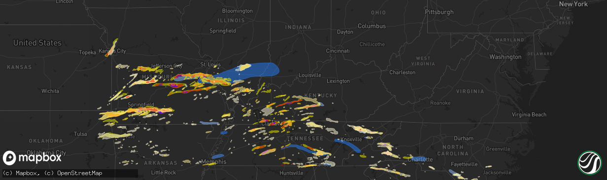
Hail Map in Kentucky on May 8, 2024
The weather event in Kentucky on May 8, 2024 includes Hail, Wind, and Tornado maps. 21 states and 1,905 cities were impacted and suffered possible damage. The total estimated number of properties impacted is 41,102.
Hail
Wind
Tornado
41,102
Estimated number of impacted properties by a 1.00" hail or larger10,875
Estimated number of impacted properties by a 1.75" hail or larger923
Estimated number of impacted properties by a 2.50" hail or largerStorm reports in Kentucky
Kentucky
| Date | Description |
|---|---|
| 05/08/20246:59 PM CDT | A tree was reported to have been blown down onto ky 834 w about 0.25 miles from ky 90. The event time is radar estimated. |
| 05/08/20246:59 PM CDT | Numerous power outages reported across butler county. Reported by wxornotbg on social media. |
| 05/08/20246:57 PM CDT | Trees and limbs down and ham radio antenna damaged on chester johnson road. |
| 05/08/20246:56 PM CDT | Powerlines were reported to have been blown down on old bethel church road. The event time is radar estimated. |
| 05/08/20246:50 PM CDT | Kentucky mesonet observation. |
| 05/08/20246:50 PM CDT | Few trees down in area of knifley road and holmes bend road. |
| 05/08/20246:40 PM CDT | Trees down on a house in campbellsville. |
| 05/08/20246:30 PM CDT | Generic information of trees and powerlines down across the county. |
| 05/08/20245:51 PM CDT | Power lines down over road. |
| 05/08/20245:25 PM CDT | Large tree fell on home and garage walls and roof blown down. Reported by public on social media with pictures. |
| 05/08/20245:20 PM CDT | Tree and powerline down across ky highway 210. |
| 05/08/20245:14 PM CDT | Delayed report of multiple trees down in fountain run. |
| 05/08/20244:38 PM CDT | Picture of golf ball size hail sent to the nws near rt 68 and mell rd. |
| 05/08/20244:25 PM CDT | Tree down over road... And water over road. |
| 05/08/20244:20 PM CDT | A few trees down near ky 551/ ky 70. |
| 05/08/20244:12 PM CDT | A local report indicates 1.00 inch wind near Pleasant Ridge |
| 05/08/20244:07 PM CDT | Media report of golf ball size hail near clarkson. |
| 05/08/20244:07 PM CDT | Media report of golf ball size hail south of clarkson. |
| 05/08/20244:03 PM CDT | Trees down reported. |
| 05/08/20244:02 PM CDT | Video shared on social media of a tornado over lake barkley. Location approximate. |
| 05/08/20244:01 PM CDT | A local report indicates 1.00 inch wind near 5 NNW Fort Campbell Nor |
| 05/08/20243:56 PM CDT | Trees down. |
| 05/08/20243:55 PM CDT | Report from mping: quarter |
| 05/08/20243:54 PM CDT | Quarter sized hail reported by public and shared by wxornotbg on social media. |
| 05/08/20243:40 PM CDT | Tree limbs down across ky highway 2094 in the waverly community. Time estimated by radar. |
| 05/08/20243:39 PM CDT | Telephone pole blown down on ky141 at tl bishop rd. |
| 05/08/20243:39 PM CDT | Telephone pole blown down on ky141 at tl bishopthe intersection of nc 211 and e main in aberdeen. |
| 05/08/20243:38 PM CDT | Corrects previous hail report from 1 ssw exie. Picture of golf ball size hail sent to the nws near rt 68 and mell rd. Time corrected. |
| 05/08/20243:35 PM CDT | Large trees uprooted... Tree fell on house. |
| 05/08/20243:35 PM CDT | Corrects previous tstm wnd dmg report from livermore. Large trees uprooted... Tree fell on house. Damage to porch. |
| 05/08/20243:17 PM CDT | Video showing quarter sized hail falling on residential property reported by public on social media. |
| 05/08/20243:15 PM CDT | Golfball size hail reported with pictures off of highway 88 near us31e. |
| 05/08/20243:10 PM CDT | Report from mping: quarter |
| 05/08/20243:08 PM CDT | Reported in the area of seymour-bear wallow rd and hwy 218. |
| 05/08/20243:02 PM CDT | Golf ball size hail reported in morgantown at the cross roads of provo rd and meredith rd. |
| 05/08/20243:00 PM CDT | A local report indicates 1.75 inch wind near 1 SE Drakesboro |
| 05/08/20243:00 PM CDT | Trees down... Hail damage to vehicles and one house with significant damage... Power outages reported. |
| 05/08/20242:53 PM CDT | A local report indicates 1.50 inch wind near 1 ESE Cave City |
| 05/08/20242:53 PM CDT | Trees down. |
| 05/08/20242:53 PM CDT | A local report indicates 1.75 inch wind near 1 ESE Cave City |
| 05/08/20242:45 PM CDT | A local report indicates 1.00 inch wind near 3 SSE Drakesboro |
| 05/08/20242:27 PM CDT | A local report indicates 1.00 inch wind near 2 NNE Smiths Grove |
| 05/08/20242:23 PM CDT | A local report indicates 1.00 inch wind near Oakland |
| 05/08/20242:05 PM CDT | Tree fell on a vacant home in sullivan. |
| 05/08/20241:19 PM CDT | Dime to quarter size hail. |
| 05/08/20241:11 PM CDT | Quarter sized hail reported by public and shared by broadcast media wnky news 40 on social media. |
| 05/08/20241:10 PM CDT | A local report indicates 1.75 inch wind near Lewisburg |
| 05/08/20241:06 PM CDT | Possible tornado damage to a barn. |
| 05/08/202412:45 PM CDT | Roof damage and an outhouse destroyed... Time estimated from radar. |
| 05/08/20248:19 AM CDT | About four trees snapped or uprooted. |
| 05/08/20248:19 AM CDT | Large trees down over road... Above ground pool side blown in. |
| 05/08/20248:16 AM CDT | Trees down on cedar street. |
| 05/08/20248:02 AM CDT | Large tree limbs down. |
| 05/08/20247:50 AM CDT | Trees down near symsonia. Time estimated. |
| 05/08/20247:31 AM CDT | Trees down with power outages. |
| 05/08/20247:12 AM CDT | Large tree down on power lines along highway 167 near patten creek rd. Time estimated by radar. |
| 05/08/20241:10 AM CDT | Trees/powerlines down along riverview dr. |
| 05/08/202412:32 AM CDT | Power lines down on old trenton road. |
| 05/08/202412:12 AM CDT | A local report indicates 1.00 inch wind near Hopkinsville |
| 05/07/20249:50 PM CDT | Widespread wind damage across the county. Homes damaged... Trees down and power poles snapped. |
| 05/07/20249:49 PM CDT | An ef-1 tornado touched down briefly 4 miles southwest of owensboro... Ky. One farm outbuilding was severely damaged... With heavy machinery tossed or pushed into nearb |
| 05/07/20249:44 PM CDT | Several large trees were uprooted along highway 56 west of west louisville. About 10 wooden power poles were snapped or suffered damage to cross-members. Nearly all dam |
| 05/07/20249:41 PM CDT | An ef-0 tornado touched down 3 miles west northwest of west louisville in western daviess county... Traveled 3.14 miles east southeast... And lifted at west louisville. |
| 05/07/20249:39 PM CDT | An ef-0 tornado touched down 2 miles northwest of st. Joseph in western daviess county... Traveled eastward 2.72 miles and lifted 1 mile northeast of st. Joseph. Numero |
| 05/07/20247:34 PM CDT | Report from the public of numerous trees down near the 2300 block of louisville rd. |
| 05/07/20247:34 PM CDT | Corrects wrong location on report. Report from the public of numerous trees down on louisville rd. |
| 05/07/20247:34 PM CDT | Corrects previous tstm wnd dmg report from warren county. Corrects wrong location on report. Report from the public of numerous trees down on louisville rd. |
| 05/07/20247:30 PM CDT | Social media report of a large tree down across ky 229 at intersection of robinson creek road with electric wires also down. Both lanes are blocked with traffic using t |
| 05/07/20247:29 PM CDT | Reported at friendship road and new holt road. |
| 05/07/20247:20 PM CDT | A local report indicates 1.00 inch wind near 3 W Lone Oak |
| 05/07/20247:12 PM CDT | Tree down on madisonville road near the mudsink community. Time estimated. |
| 05/07/20247:09 PM CDT | Report from mping: half dollar |
| 05/07/20247:05 PM CDT | Multiple trees down on caneyville rd near brownsville rd. Delayed report. |
| 05/07/20247:00 PM CDT | Multiple trees down on caneyville road between possum hollow road and dexterville road. |
| 05/07/20247:00 PM CDT | Trees down along carl pharris road. |
All States Impacted by Hail Map on May 8, 2024
Cities Impacted by Hail Map on May 8, 2024
- Hot Springs National Park, AR
- Little Rock, AR
- Scott, AR
- North Little Rock, AR
- Lonoke, AR
- England, AR
- Carlisle, AR
- Hazen, AR
- Stuttgart, AR
- De Valls Bluff, AR
- Clarendon, AR
- Roe, AR
- Shawnee, KS
- Mission, KS
- Prairie Village, KS
- Overland Park, KS
- Kansas City, MO
- Kansas City, KS
- Hickman, KY
- Monticello, KY
- Joelton, TN
- Whites Creek, TN
- Lenexa, KS
- Lafayette, TN
- Red Boiling Springs, TN
- Garden City, MO
- Harrisonville, MO
- Mayfield, KY
- Leawood, KS
- Creighton, MO
- Archie, MO
- Albany, KY
- Olathe, KS
- Riverside, MO
- Liberty, MO
- Clinton, KY
- Whitleyville, TN
- Goodlettsville, TN
- Moss, TN
- Gainesboro, TN
- Blairstown, MO
- Urich, MO
- Independence, MO
- Celina, TN
- Pall Mall, TN
- Trimble, MO
- Holt, MO
- Smithville, MO
- Plattsburg, MO
- Kearney, MO
- Lathrop, MO
- Montrose, MO
- Chilhowee, MO
- Holden, MO
- Hilham, TN
- East Prairie, MO
- Clinton, MO
- Hendersonville, TN
- Benton, KY
- Symsonia, KY
- Hickory, KY
- Stearns, KY
- Rickman, TN
- Cookeville, TN
- Deepwater, MO
- Oneida, TN
- Calhoun, MO
- Monroe, TN
- Allons, TN
- Livingston, TN
- Calvert City, KY
- Windsor, MO
- Alpine, TN
- Paducah, KY
- Allred, TN
- Boaz, KY
- Wilder, TN
- Jamestown, TN
- Lincoln, MO
- Ledbetter, KY
- Smithland, KY
- Ionia, MO
- Green Ridge, MO
- Cole Camp, MO
- Sedalia, MO
- Mora, MO
- La Follette, TN
- White House, TN
- Speedwell, TN
- Duff, TN
- Deer Lodge, TN
- Allardt, TN
- Sunbright, TN
- Stover, MO
- Lancing, TN
- Robbins, TN
- Versailles, MO
- New Tazewell, TN
- Sharps Chapel, TN
- Florence, MO
- Maynardville, TN
- Barnett, MO
- Cottontown, TN
- Washburn, TN
- Springfield, TN
- Greenbrier, TN
- Madison, TN
- Tazewell, TN
- Osage Beach, MO
- Sunrise Beach, MO
- Eldon, MO
- Russellville, MO
- California, MO
- Rutledge, TN
- Kaiser, MO
- Monterey, TN
- Tuscumbia, MO
- Thorn Hill, TN
- Oakdale, TN
- Wartburg, TN
- Latham, MO
- Lake Ozark, MO
- Morristown, TN
- Bean Station, TN
- Talbott, TN
- Eugene, MO
- Ulman, MO
- Iberia, MO
- Henley, MO
- Olean, MO
- Rocky Mount, MO
- Clarkrange, TN
- Jefferson City, MO
- Russellville, TN
- Meta, MO
- Saint Thomas, MO
- Westphalia, MO
- Dixon, MO
- Crocker, MO
- Saint Elizabeth, MO
- Mooresburg, TN
- Brinktown, MO
- Whitesburg, TN
- Bulls Gap, TN
- Mohawk, TN
- Jefferson City, TN
- Vienna, MO
- Argyle, MO
- Midway, TN
- Mosheim, TN
- Greeneville, TN
- Vichy, MO
- Belle, MO
- Knoxville, TN
- Freeburg, MO
- Linn, MO
- Koeltztown, MO
- Saint James, MO
- Bland, MO
- Owensville, MO
- Strawberry Plains, TN
- New Market, TN
- Rolla, MO
- Cuba, MO
- Dandridge, TN
- Afton, TN
- Cape Girardeau, MO
- White Pine, TN
- Newport, TN
- Sullivan, MO
- Bourbon, MO
- Rosebud, MO
- Limestone, TN
- Chuckey, TN
- Seymour, TN
- Jonesboro, IL
- Telford, TN
- Bybee, TN
- Leasburg, MO
- Jonesborough, TN
- Cobden, IL
- Anna, IL
- Parrottsville, TN
- Sevierville, TN
- Del Rio, TN
- Gerald, MO
- Buncombe, IL
- Vienna, IL
- Rogersville, TN
- Saint Clair, MO
- Goreville, IL
- Cosby, TN
- Lonedell, MO
- Richwoods, MO
- Creal Springs, IL
- Marion, IL
- Marshall, NC
- Hot Springs, NC
- Cherokee, NC
- Leslie, MO
- Hartford, TN
- Mars Hill, NC
- Weaverville, NC
- Grubville, MO
- Dittmer, MO
- Luebbering, MO
- Mountain Rest, SC
- Flag Pond, TN
- Fletcher, MO
- Barnardsville, NC
- Robertsville, MO
- Leicester, NC
- Alexander, NC
- Tamassee, SC
- Salem, SC
- Hopkinsville, KY
- Hillsboro, MO
- De Soto, IL
- Elkville, IL
- Murphysboro, IL
- De Soto, MO
- Burnsville, NC
- Mulkeytown, IL
- Royalton, IL
- Pembroke, KY
- Elkton, KY
- Summer Shade, KY
- Glasgow, KY
- Scottsville, KY
- Cedar Hill, MO
- Blackwell, MO
- Potosi, MO
- Christopher, IL
- Buckner, IL
- Sunset, SC
- Pickens, SC
- Six Mile, SC
- Benton, IL
- Festus, MO
- Old Fort, NC
- Hendersonville, NC
- Fletcher, NC
- Arden, NC
- Fairview, NC
- Chetopa, KS
- Lewisburg, KY
- Sharon Grove, KY
- Robbinsville, NC
- Union Mills, NC
- Bartlett, KS
- Black Mountain, NC
- Lucas, KY
- Waynesville, NC
- Lake Junaluska, NC
- Nevada, MO
- Clyde, NC
- Pevely, MO
- Herculaneum, MO
- Crystal City, MO
- Russellville, KY
- Oswego, KS
- House Springs, MO
- Drakesboro, KY
- Central City, KY
- Walker, MO
- Marion, NC
- Asheville, NC
- Beaver Dam, KY
- Gerton, NC
- Mills River, NC
- Erwin, TN
- Cadet, MO
- Valmeyer, IL
- Barnhart, MO
- Lake Lure, NC
- Easley, SC
- Cromwell, KY
- Waterloo, IL
- Fults, IL
- Mill Spring, NC
- Rutherfordton, NC
- Horse Branch, KY
- Rosine, KY
- Greenville, SC
- Caledonia, MO
- Belgrade, MO
- Harwood, MO
- Valles Mines, MO
- French Village, MO
- Auburn, KY
- Bloomsdale, MO
- El Dorado Springs, MO
- Bryson City, NC
- Bonne Terre, MO
- Irondale, MO
- Mineral Point, MO
- Bismarck, MO
- Park Hills, MO
- Franklin, NC
- Olaton, KY
- Leadwood, MO
- Prairie Du Rocher, IL
- Marion, KY
- Salem, KY
- Bluejacket, OK
- Welch, OK
- Nebo, NC
- Liberal, MO
- Oronogo, MO
- Jasper, MO
- Cullowhee, NC
- Schell City, MO
- Princeton, KY
- Dawson Springs, KY
- Morgantown, KY
- Rockfield, KY
- Sainte Genevieve, MO
- Sylva, NC
- Whittier, NC
- Saint Charles, KY
- Nortonville, KY
- Evansville, IL
- Modoc, IL
- Ellis Grove, IL
- Tyringham, MA
- Otis, MA
- Monterey, MA
- Blandford, MA
- East Otis, MA
- Great Barrington, MA
- Sheffield, MA
- South Egremont, MA
- Lamar, MO
- Caneyville, KY
- Falls Of Rough, KY
- Fredonia, KY
- Forest City, NC
- Spindale, NC
- Topton, NC
- Bowling Green, KY
- Bostic, NC
- Red Bud, IL
- Ellenboro, NC
- Walsh, IL
- Madisonville, KY
- Mortons Gap, KY
- White Plains, KY
- Graham, KY
- Sandisfield, MA
- Crofton, KY
- Chester, IL
- Farmington, MO
- Sturgis, KY
- Puryear, TN
- Hampton, KY
- Miami, OK
- Clay, KY
- Lawndale, NC
- Shelby, NC
- Tiptonville, TN
- Hornbeak, TN
- Butler, MO
- Appleton City, MO
- Nashville, TN
- Ashland City, TN
- Russell, MA
- Granville, MA
- Greenville, KY
- Osceola, MO
- Collins, MO
- Sparta, IL
- Mooresboro, NC
- Huntington, MA
- Westfield, MA
- Southampton, MA
- Tuckasegee, NC
- Pleasant View, TN
- Stockton, MO
- North Miami, OK
- Adams, TN
- Cedar Hill, TN
- Quapaw, OK
- Commerce, OK
- Beech Creek, KY
- Smiths Grove, KY
- Oakland, KY
- Simpsonville, SC
- Woodruff, SC
- Greer, SC
- Old Hickory, TN
- Vinita, OK
- Clarksville, TN
- Troy, TN
- Saint Mary, MO
- Ironton, MO
- Doe Run, MO
- Kings Mountain, NC
- Cherryville, NC
- Bessemer City, NC
- Holyoke, MA
- West Springfield, MA
- Chicopee, MA
- Afton, OK
- Beechmont, KY
- Jerico Springs, MO
- Lockwood, MO
- Browder, KY
- Belton, KY
- Arcola, MO
- Quincy, MO
- Weaubleau, MO
- Hazel, KY
- New Concord, KY
- Murray, KY
- Rosman, NC
- Balsam Grove, NC
- Lake Toxaway, NC
- Park City, KY
- Rocky Hill, KY
- Morganfield, KY
- Fountain Inn, SC
- Providence, KY
- Nebo, KY
- Amherst, MA
- Hadley, MA
- Northampton, MA
- Buchanan, TN
- Crouse, NC
- Elizabethtown, IL
- Cave In Rock, IL
- Eldridge, MO
- Melber, KY
- Union City, TN
- Steeleville, IL
- Rosiclare, IL
- Percy, IL
- Camdenton, MO
- Lebanon, MO
- Stoutland, MO
- Montreal, MO
- Roebuck, SC
- Pauline, SC
- Petersham, MA
- Enoree, SC
- Dallas, NC
- Cave City, KY
- Gastonia, NC
- Campbell Hill, IL
- Ava, IL
- Horse Cave, KY
- Coulterville, IL
- Cutler, IL
- Pinckneyville, IL
- Wheatland, MO
- Lincolnton, NC
- Manitou, KY
- Rochester, KY
- Fairland, OK
- Mauldin, SC
- Waverly, KY
- Wyandotte, OK
- Shutesbury, MA
- Carbondale, IL
- Fulton, KY
- South Fulton, TN
- Greenfield, TN
- Ludlow, MA
- Springfield, MA
- Indian Orchard, MA
- Wilbraham, MA
- Corydon, KY
- Gaffney, SC
- Ullin, IL
- Grand Chain, IL
- Karnak, IL
- Martin, TN
- Golden City, MO
- Austin, KY
- Pomona, IL
- Magnolia, MN
- Kanaranzi, MN
- Fredericktown, MO
- Rockwood, IL
- Athol, MA
- Templeton, MA
- Hubbardston, MA
- Gardner, MA
- Barre, MA
- Buffalo, SC
- Jonesville, SC
- Hardyville, KY
- Center, KY
- Uniontown, KY
- Kenneth, MN
- Cross Timbers, MO
- Hermitage, MO
- Cross Plains, TN
- Vergennes, IL
- Robards, KY
- Sebree, KY
- Hanson, KY
- Chatham, VA
- Brookport, IL
- Seneca, MO
- Neosho, MO
- Joplin, MO
- Dover, TN
- Knob Lick, KY
- Union, SC
- Monson, MA
- Palmer, MA
- Mount Holly, NC
- Gilbertsville, KY
- Reagan, TN
- Jacks Creek, TN
- Lexington, TN
- Huron, TN
- Perryville, MO
- Palmersville, TN
- Dresden, TN
- Luverne, MN
- Gleason, TN
- McKenzie, TN
- Columbus, KS
- New Haven, MO
- Richland, MO
- Greenfield, MO
- Blacksburg, SC
- Belknap, IL
- Dixon, KY
- Smyrna, SC
- Henderson, KY
- Sacramento, KY
- Big Rock, TN
- Cottage Grove, TN
- Slaughters, KY
- Weir, KS
- Paris, TN
- Lowell, NC
- Cramerton, NC
- Charlotte, NC
- McAdenville, NC
- Belmont, NC
- Stanley, NC
- Bumpus Mills, TN
- Three Rivers, MA
- Edwards, MO
- Warsaw, MO
- Preston, MO
- Matthews, NC
- Du Quoin, IL
- Jetson, KY
- Brownsville, KY
- Roundhill, KY
- Westminster, MA
- Wales, MA
- Henry, TN
- Dadeville, MO
- Rumsey, KY
- Scotts Hill, TN
- Sturbridge, MA
- Brimfield, MA
- Fiskdale, MA
- Hardin, KY
- Orlinda, TN
- Mount Vernon, IN
- Island, KY
- East Longmeadow, MA
- Hampden, MA
- Charlton, MA
- Holland, MA
- Edmonton, KY
- Gretna, VA
- Cadiz, KY
- York, SC
- Clover, SC
- Energy, IL
- Carterville, IL
- Herrin, IL
- Munfordville, KY
- Stafford Springs, CT
- Southbridge, MA
- Dudley, MA
- Chelsea, OK
- Dukedom, TN
- Grand Rivers, KY
- North Grosvenordale, CT
- Quinebaug, CT
- Woodstock Valley, CT
- Eastford, CT
- Pomfret Center, CT
- Woodstock, CT
- Greensburg, KY
- Concord, NC
- Midland, NC
- Harrisburg, NC
- Waynesville, MO
- Portland, TN
- Macks Creek, MO
- Climax Springs, MO
- Roach, MO
- Granby, MO
- Parsons, TN
- Decaturville, TN
- Darden, TN
- Cumberland City, TN
- Indian Mound, TN
- Livermore, KY
- Calhoun, KY
- Centertown, KY
- Dunmor, KY
- Fort Campbell, KY
- Woodlawn, TN
- Shoals, IN
- Almo, KY
- Monroe, NC
- Indian Trail, NC
- Golconda, IL
- Eddyville, IL
- Simpson, IL
- Adair, OK
- Dowell, IL
- Johnston City, IL
- Big Cabin, OK
- Mansfield, TN
- Pittsburg, IL
- Linden, TN
- Herndon, KY
- La Fayette, KY
- Newburg, MO
- Jerome, MO
- Springville, TN
- Linn Creek, MO
- Pierce City, MO
- Hartford, KY
- Stark City, MO
- Utica, KY
- Woodlawn, IL
- New Athens, IL
- Hecker, IL
- Addieville, IL
- Nashville, IL
- Lenzburg, IL
- Richview, IL
- Brumley, MO
- Ashley, IL
- Mount Vernon, IL
- Williams, IN
- Palmyra, TN
- Cunningham, TN
- Bee Spring, KY
- Leitchfield, KY
- Herod, IL
- Carlisle, SC
- Putnam, CT
- Thompson, CT
- Saint Robert, MO
- New Salem, IL
- Oxford, MA
- Webster, MA
- Ashford, CT
- Columbia, KY
- Campbellsville, KY
- Thompsonville, IL
- Clear Lake, SD
- Brandt, SD
- Stanfield, NC
- Big Sandy, TN
- Carrier Mills, IL
- Waynesboro, TN
- Clifton, TN
- Bath Springs, TN
- Makanda, IL
- Canby, MN
- Stewart, TN
- Beaufort, MO
- Clarkson, KY
- Cub Run, KY
- Goodman, MO
- Monett, MO
- Wentworth, MO
- Lobelville, TN
- Harrisburg, IL
- Mammoth Cave, KY
- Chester, SC
- Lunenburg, VA
- Victoria, VA
- Keysville, VA
- Galatia, IL
- Lometa, TX
- Fordsville, KY
- Dundee, KY
- Remsen, IA
- Marcus, IA
- Dayville, CT
- Chepachet, RI
- Westmoreland, TN
- Bethpage, TN
- Oak Grove, KY
- Maxton, NC
- Rowland, NC
- West Frankfort, IL
- Eddyville, KY
- Knifley, KY
- Junction, IL
- Stonefort, IL
- Alto Pass, IL
- Mindenmines, MO
- Marshville, NC
- Wingate, NC
- Gary, SD
- Pittsburg, KS
- Hohenwald, TN
- Oakboro, NC
- Lampasas, TX
- Opolis, KS
- Asbury, MO
- Licking, MO
- Duke, MO
- Pembroke, NC
- Eldorado, IL
- Verona, MO
- Centerville, TN
- Salem, MO
- Kenbridge, VA
- Cherryville, MO
- Waverly, TN
- Peachland, NC
- Lancaster, SC
- McEwen, TN
- Gravois Mills, MO
- Pryor, OK
- Trenton, KY
- Equality, IL
- Tennessee Ridge, TN
- Bonnieville, KY
- Taylors, SC
- Polkton, NC
- Grove, OK
- Cook Sta, MO
- Steelville, MO
- Roby, MO
- Beulah, MO
- Danielson, CT
- Adolphus, KY
- Anderson, MO
- Erin, TN
- Magnolia, KY
- Upton, KY
- Clarkton, NC
- Council, NC
- Norris City, IL
- Burna, KY
- Nunnelly, TN
- Liberty, KY
- Dunnville, KY
- Millwood, KY
- Wadesboro, NC
- Mount Vernon, MO
- Freistatt, MO
- Aurora, MO
- Guthrie, KY
- Fairmont, NC
- Lumberton, NC
- Sheldon, MO
- Bronaugh, MO
- Strang, OK
- Devils Elbow, MO
- Diamond, MO
- Ridgway, IL
- Shawneetown, IL
- Cumberland Furnace, TN
- Vanleer, TN
- Dickson, TN
- Charlotte, TN
- Marionville, MO
- Hampshire, TN
- Mount Pleasant, TN
- Billings, MO
- Crane, MO
- Clever, MO
- Edgar Springs, MO
- Lenox, MO
- Sneedville, TN
- Tiff City, MO
- Summertown, TN
- Orrum, NC
- Copperas Cove, TX
- Bon Aqua, TN
- Holland, KY
- Summersville, KY
- Carmi, IL
- Gatesville, TX
- Chapmansboro, TN
- Eucha, OK
- Milo, MO
- Fountain Run, KY
- Cassatt, SC
- Bishopville, SC
- Big Clifty, KY
- Monroe City, MO
- Palmyra, MO
- Brooklyn, CT
- Gamaliel, KY
- Mount Sherman, KY
- Fairview, MO
- Rocky Comfort, MO
- Stella, MO
- White Bluff, TN
- Bladenboro, NC
- Spavinaw, OK
- Riegelwood, NC
- Jay, OK
- Grantsburg, IL
- Kingston Springs, TN
- South West City, MO
- Noel, MO
- Davisville, MO
- Columbia, IL
- Holladay, TN
- Duck River, TN
- Sonora, KY
- White Mills, KY
- Buffalo, KY
- Tompkinsville, KY
- Mount Hermon, KY
- East Killingly, CT
- Foster, RI
- Sterling, CT
- Boss, MO
- Clayville, RI
- Hope, RI
- Moosup, CT
- Kodak, TN
- Nixa, MO
- Purdy, MO
- Wheaton, MO
- Imperial, MO
- Patrick, SC
- Hartsville, SC
- Belleville, IL
- Lanagan, MO
- Pineville, MO
- Lebanon, KY
- Gradyville, KY
- Millstadt, IL
- Kelly, NC
- Columbia, TN
- Locust Grove, OK
- Pegram, TN
- Fontana Dam, NC
- Oliver Springs, TN
- Evergreen, NC
- Yosemite, KY
- Brookline, MO
- Springfield, MO
- Ozark, MO
- Highlandville, MO
- Gravette, AR
- Fairview Heights, IL
- O'Fallon, IL
- Spring Hill, TN
- Rose, OK
- Salina, OK
- Mannsville, KY
- Bradfordsville, KY
- Elk Horn, KY
- Beaumont, KY
- Currie, NC
- Gallatin, TN
- Sulphur Springs, AR
- Powell, MO
- Mount Juliet, TN
- Hampton, CT
- Society Hill, SC
- Lamar, SC
- Bethune, SC
- Cassville, MO
- Butterfield, MO
- Rogersville, MO
- Bixby, MO
- McBee, SC
- Sparta, MO
- Viburnum, MO
- Belleview, MO
- Primm Springs, TN
- Lewisburg, TN
- Bolton, NC
- Lyles, TN
- Galena, MO
- Washburn, MO
- Southside, TN
- Peggs, OK
- Hulbert, OK
- Exeter, MO
- Hustonville, KY
- Bruner, MO
- Fordland, MO
- Colcord, OK
- Fort Hood, TX
- Darlington, SC
- Seymour, MO
- New Salem, MA
- Freeburg, IL
- Oakland, RI
- Harrisville, RI
- Mapleville, RI
- Timmonsville, SC
- Lebanon, TN
- College Grove, TN
- Delco, NC
- North Scituate, RI
- Cranston, RI
- Johnston, RI
- Providence, RI
- Tiverton, RI
- Fall River, MA
- Ava, MO
- Westport, MA
- North Dartmouth, MA
- New Bedford, MA
- Warwick, RI
- Riverside, RI
- Florence, SC
- Willington, CT
- Wellfleet, MA
- Franklin, TN
- Chaplin, CT
- Lowry City, MO
- Shannon, NC
- Castalian Springs, TN
- Pascoag, RI
- Chapel Hill, TN
- Eagleville, TN
- Ponce De Leon, MO
- Mascoutah, IL
- Hodgenville, KY
- Saint Pauls, NC
- Reeds Spring, MO
- Spokane, MO
- New Baden, IL
- Seligman, MO
- Tahlequah, OK
- Chestnutridge, MO
- Chadwick, MO
- Forsyth, MO
- Garrison, MO
- Mckinney, TX
- Princeton, TX
- Blue Ridge, TX
- Baldwin, IL
- Tamaroa, IL
- Kansas, OK
- Marissa, IL
- Oakdale, IL
- Tilden, IL
- Proctor, OK
- Scheller, IL
- Du Bois, IL
- Sesser, IL
- Waltonville, IL
- Ogden, IA
- Cape Fair, MO
- Hartsville, TN
- Boone, IA
- Albers, IL
- Thompsons Station, TN
- Barrington, RI
- Pea Ridge, AR
- Bella Vista, AR
- Bentonville, AR
- Centerton, AR
- Bremen, KY
- Eagle Rock, MO
- Warsaw, NC
- Turkey, NC
- Magnolia, NC
- Leland, NC
- Bethelridge, KY
- Eubank, KY
- Canmer, KY
- Oaks, OK
- Cambria, IL
- Franklin, KY
- Adairville, KY
- Alexis, NC
- Iron Station, NC
- Clinton, NC
- Watts, OK
- Westville, OK
- Greene, RI
- East Providence, RI
- Swansea, MA
- Seekonk, MA
- Twin Oaks, OK
- Warren, RI
- Bristol, RI
- Somerset, MA
- Fairhaven, MA
- Acushnet, MA
- Mattapoisett, MA
- Coventry, RI
- Rockvale, TN
- Christiana, TN
- Murfreesboro, TN
- Unionville, TN
- Mansfield, MO
- Bell Buckle, TN
- Oldfield, MO
- Plainfield, CT
- Canterbury, CT
- Central Village, CT
- Spencer, IA
- Fair Bluff, NC
- Rogers, AR
- Nichols, SC
- Germantown, IL
- McHenry, KY
- Shell Knob, MO
- Kimberling City, MO
- Chadbourn, NC
- Cerro Gordo, NC
- Kirksey, KY
- Gordonsville, TN
- Golden, MO
- Riddleton, TN
- Dixon Springs, TN
- Carthage, TN
- Kenansville, NC
- Garfield, AR
- Rockport, KY
- Truro, MA
- Eastham, MA
- Norwood, MO
- Macomb, MO
- Drury, MO
- Falmouth, MA
- North Falmouth, MA
- East Falmouth, MA
- Farmersville, TX
- Mashpee, MA
- Cotuit, MA
- Portsmouth, RI
- Siloam Springs, AR
- Summers, AR
- Lincoln, AR
- South Dartmouth, MA
- Kuttawa, KY
- West Warwick, RI
- East Greenwich, RI
- West Greenwich, RI
- Bennington, OK
- Buffalo Valley, TN
- Chestnut Mound, TN
- Elmwood, TN
- Taneyville, MO
- Walnut Shade, MO
- Berryville, AR
- Eureka Springs, AR
- Branson, MO
- Cerulean, KY
- Bokchito, OK
- Telephone, TX
- North Kingstown, RI
- Prudence Island, RI
- Fayetteville, AR
- Prairie Grove, AR
- Vanzant, MO
- Mountain Grove, MO
- Beulaville, NC
- Pink Hill, NC
- Boswell, OK
- Ames, IA
- Readyville, TN
- Bradleyville, MO
- Lexington, AL
- Centralia, IL
- Antlers, OK
- Atoka, OK
- Baxter, TN
- Bloomington Springs, TN
- Park Hill, OK
- Story City, IA
- Burkesville, KY
- Granville, TN
- Lampe, MO
- Odin, IL
- Sandoval, IL
- Hermitage, TN
- Porum, OK
- Kevil, KY
- Gilbert, IA
- Randall, IA
- Effingham, SC
- Cuttyhunk, MA
- Woods Hole, MA
- Little Compton, RI
- Woodbury, TN
- Mcminnville, TN
- Westport Point, MA
- Bradyville, TN
- Morrison, TN
- Moyers, OK
- Finley, OK
- Willow Springs, MO
- Cabool, MO
- Beechgrove, TN
- Wartrace, TN
- Manchester, TN
- Farmington, AR
- Stigler, OK
- Hermann, MO
- Richlands, NC
- Anderson, AL
- Five Points, TN
- Loretto, TN
- Dix, IL
- Kell, IL
- Texico, IL
- Iuka, IL
- Bluford, IL
- Salem, IL
- Oak Grove, AR
- Green Forest, AR
- Blue Eye, MO
- Squires, MO
- Irvington, IL
- Dutton, AL
- Section, AL
- Welling, OK
- Arthur City, TX
- Sumner, TX
- Shelbyville, TN
- Pulaski, TN
- Hollister, MO
- Cunningham, KY
- Culleoka, TN
- Walnut Hill, IL
- Cookson, OK
- Thornfield, MO
- Springdale, AR
- Hindsville, AR
- Laurinburg, NC
- Gibson, NC
- Laurel Hill, NC
- Trenton, NC
- Mountain View, MO
- Elkins, AR
- Okawville, IL
- Hoyleton, IL
- Ewing, IL
- Ina, IL
- Bonnie, IL
- Whittington, IL
- Opdyke, IL
- McLeansboro, IL
- Mill Shoals, IL
- Dahlgren, IL
- Geff, IL
- Keenes, IL
- Rinard, IL
- Sims, IL
- Springerton, IL
- Fairfield, IL
- Belle Rive, IL
- Wayne City, IL
- Barnhill, IL
- Cisne, IL
- Macedonia, IL
- Enfield, IL
- Johnsonville, IL
- Xenia, IL
- Clay City, IL
- Flora, IL
- Burnt Prairie, IL
- Golden Gate, IL
- Albion, IL
- Olney, IL
- Noble, IL
- West Salem, IL
- Claremont, IL
- Bone Gap, IL
- Bridgeport, IL
- Mount Carmel, IL
- Calhoun, IL
- Ellery, IL
- Browns, IL
- Mount Erie, IL
- Parkersburg, IL
- Sumner, IL
- Owensville, IN
- Allendale, IL
- Griffin, IN
- Bellmont, IL
- Crossville, IL
- Grayville, IL
- Coventry, CT
- Storrs Mansfield, CT
- Celeste, TX
- Metropolis, IL
- Sweeden, KY
- Stilwell, OK
- Pisgah, AL
- Henagar, AL
- Clayton, OK
- Snow, OK
- Berger, MO
- Danbury, IA
- Anthon, IA
- Lawrenceburg, TN
- Goodspring, TN
- Leoma, TN
- Minor Hill, TN
- West Paducah, KY
- Huntsville, AR
- Vineyard Haven, MA
- Hugo, OK
- Radcliffe, IA
- Fancy Farm, KY
- Arlington, KY
- Greenville, TX
- Suffolk, VA
- Kirbyville, MO
- Cedarcreek, MO
- Rogersville, AL
- Athens, AL
- Paris, TX
- Grant, OK
- Powderly, TX
- Prospect, TN
- Elkmont, AL
- West Fork, AR
- Shallotte, NC
- Supply, NC
- Mccurtain, OK
- Caddo Mills, TX
- Nevada, TX
- Zearing, IA
- Hubbard, IA
- Battle Creek, IA
- Correctionville, IA
- Canehill, AR
- Killen, AL
- McCallsburg, IA
- Garden City, IA
- Cornersville, TN
- Gracey, KY
- Town Creek, AL
- Evansville, AR
- Alpena, AR
- Wasola, MO
- Gainesville, MO
- Mansfield Center, CT
- Ardmore, TN
- Osterville, MA
- Rock Island, TN
- Spencer, TN
- Lester, AL
- Blossom, TX
- Detroit, TX
- Bagwell, TX
- North Windham, CT
- Tuskahoma, OK
- Dellrose, TN
- Wilburton, OK
- Talihina, OK
- Hillsboro, AL
- Courtland, AL
- Zanoni, MO
- Princeton, AL
- Winslow, AR
- Estillfork, AL
- Keota, OK
- New Providence, IA
- Bokoshe, OK
- Crossville, TN
- Wickliffe, KY
- Bardwell, KY
- Nantucket, MA
- Beersheba Springs, TN
- Altamont, TN
- Dunlap, TN
- Pikeville, TN
- Taft, TN
- Fayetteville, TN
- Broughton, IL
- Scottsboro, AL
- Eminence, MO
- Woodburn, KY
- Baltic, CT
- Scotland, CT
- Muscle Shoals, AL
- Ider, AL
- Tanner, AL
- Bunker, MO
- Langston, AL
- Dale, IL
- Loose Creek, MO
- Valley Head, AL
- Omaha, AR
- Harrison, AR
- Red Oak, OK
- Dora, MO
- Woodville, AL
- Flat Rock, AL
- Shady Point, OK
- Spiro, OK
- Rising Fawn, GA
- Campbell, TX
- Higdon, AL
- Chester, AR
- Exeter, RI
- West Plains, MO
- Pomona, MO
- Cameron, OK
- Chattanooga, TN
- Alvaton, KY
- Compton, AR
- Audubon, IA
- Stevenson, AL
- Ellington, MO
- New Haven, IL
- Black, MO
- Brush Creek, TN
- Chilmark, MA
- Chamois, MO
- Morrison, MO
- Edgartown, MA
- Tecumseh, MO
- Caulfield, MO
- Ponca, AR
- Kingston, AR
- Santa Fe, TN
- Hope Valley, RI
- Hollywood, AL
- Bonnots Mill, MO
- Olmstead, KY
- Normandy, TN
- Hillsboro, TN
- Tullahoma, TN
- Graysville, TN
- Palmer, TN
- Soddy Daisy, TN
- Menlo, GA
- Chickamauga, GA
- Lone Oak, TX
- Cumby, TX
- Sherwood, TN
- Bridgeport, AL
- South Pittsburg, TN
- Harvest, AL
- Madison, AL
- Huntsville, AL
- Mountainburg, AR
- Bakersfield, MO
- Annapolis, MO
- Jasper, AR
- Marble Falls, AR
- Saunderstown, RI
- West Kingston, RI
- Wyoming, RI
- Kingston, RI
- Wadesville, IN
- Evansville, IN
- Georgetown, TN
- La Fayette, GA
- Trenton, GA
- Pottersville, MO
- Lesterville, MO
- Centerville, MO
- Redford, MO
- Leighton, AL
- Rudy, AR
- Lead Hill, AR
- Yellville, AR
- Clarksville, TX
- Pocola, OK
- Ooltewah, TN
- Mulberry, AR
- Colo, IA
- Petersburg, TN
- Harriman, TN
- Brashear, TX
- Sale Creek, TN
- Idabel, OK
- Avery, TX
- Haworth, OK
- Jasper, TN
- Wakefield, RI
- Narragansett, RI
- Newport, RI
- Jamestown, RI
- Kingston, TN
- Oak Ridge, TN
- Lenoir City, TN
- Fort Payne, AL
- Dayton, TN
- Bryant, AL
- Flippin, AR
- Cotter, AR
- Ardmore, AL
- Toney, AL
- Flintville, TN
- Kelso, TN
- Arcadia, MO
- Gepp, AR
- Moody, MO
- Deer, AR
- Ozark, AR
- New Market, AL
- Theodosia, MO
- Birchwood, TN
- Harrison, TN
- Hollytree, AL
- Hixson, TN
- Parthenon, AR
- Coalmont, TN
- Gruetli Laager, TN
- Buzzards Bay, MA
- Protem, MO
- Rueter, MO
- New Harmony, IN
- Signal Mountain, TN
- Decatur, TN
- Coon Rapids, IA
- Dedham, IA
- Sulphur Springs, TX
- Decker, IN
- Vincennes, IN
- Patoka, IN
- Saint Francisville, IL
- Lawrenceville, IL
- Haubstadt, IN
- Hazleton, IN
- Lynnville, IN
- Oakland City, IN
- Spurgeon, IN
- Petersburg, IN
- Cynthiana, IN
- Francisco, IN
- Fort Branch, IN
- Monroe City, IN
- Princeton, IN
- Winslow, IN
- Poseyville, IN
- Elberfeld, IN
- Stendal, IN
- Tennyson, IN
- Dale, IN
- Velpen, IN
- Holland, IN
- Huntingburg, IN
- Wheatland, IN
- Otwell, IN
- Terrell, TX
- Carroll, IA
- Guild, TN
- Elizabeth, AR
- Henderson, AR
- Viola, AR
- Allensville, KY
- McDonald, TN
- Cleveland, TN
- De Kalb, TX
- Calhoun, TN
- Athens, TN
- Hartford, AR
- Huntington, AR
- Fackler, AL
- Parma, MO
- Centerville, MA
- Clinton, TN
- Mansfield, AR
- Whitwell, TN
- Quinlan, TX
- Gamaliel, AR
- Brownsboro, AL
- Bayard, IA
- Owens Cross Roads, AL
- Gurley, AL
- Point, TX
- Emory, TX
- Sturkie, AR
- Bertrand, MO
- Sikeston, MO
- Sequatchie, TN
- Riceville, TN
- Patton, MO
- Marquand, MO
- Charleston, MO
- Yantis, TX
- Bunch, OK
- Essex, MO
- Matthews, MO
- Canalou, MO
- Oark, AR
- Marshall, AR
- Saint Joe, AR
- Trion, GA
- Summerville, GA
- Western Grove, AR
- Como, TX
- Rock Spring, GA
- Watertown, TN
- Booneville, AR
- Huntland, TN
- Old Fort, TN
- Greenwood, AR
- Catron, MO
- Trenton, AL
- Paint Rock, AL
- Anniston, MO
- Owensboro, KY
- Frohna, MO
- Wills Point, TX
- Rocky Face, GA
- Pickton, TX
- Elora, TN
- Uniontown, MO
- Clarksville, AR
- Ozone, AR
- Belvidere, TN
- Salem, AR
- Mammoth Spring, AR
- Hartman, AR
- Altus, AR
- Altenburg, MO
- Aldrich, MO
- Rockwood, TN
- Farragut, TN
- Rockford, TN
- Friendsville, TN
- Louisville, TN
- Maryville, TN
- Alcoa, TN
- Walland, TN
- Edgewood, TX
- Apison, TN
- Villa Ridge, IL
- Clarkton, MO
- Malden, MO
- Gideon, MO
- Cairo, IL
- Magazine, AR
- Jackson, MO
- Wolf Lake, IL
- West Point, IL
- Bowen, IL
- Dalton, GA
- Winnsboro, TX
- Quitman, TX
- Couch, MO
- Dover, AR
- Hagarville, AR
- Barlow, KY
- Beaman, IA
- Gladbrook, IA
- Conrad, IA
- Townsend, TN
- Tallassee, TN
- Chatsworth, GA
- Jacob, IL
- Fruitvale, TX
- Grundy Center, IA
- Lincoln, IA
- Reinbeck, IA
- Waterloo, IA
- Hudson, IA
- Traer, IA
- La Porte City, IA
- Buckingham, IA
- Morrison, IA
- Dysart, IA
- Pleasant Shade, TN
- Hector, AR
- Mount Auburn, IA
- Myrtle, MO
- Marmaduke, AR
- Carthage, IL
- Scroggins, TX
- Ringgold, GA
- Resaca, GA
- Witts Springs, AR
- Leslie, AR
- Dennard, AR
- Mount Judea, AR
- Portageville, MO
- Jamaica, IA
- Warm Springs, AR
- Gatewood, MO
- Mound City, IL
- Grand Saline, TX
- Paris, AR
- Rector, AR
- Havana, AR
- Dongola, IL
- Brandon, IA
- Jesup, IA
- Griffithville, AR
- Murphy, NC
- New Madrid, MO
- Cypress, IL
- Dawson, IA
- Pittsburg, TX
- Leesburg, TX
- Gilmer, TX
- Doniphan, MO
- Maynard, AR
- Jerusalem, AR
- Ellijay, GA
- Marston, MO
- Lookout Mountain, GA
- Wildwood, GA
- Bluffton, AR
- Cushing, IA
- Holstein, IA
- Scotland, AR
- Russellville, AR
- Searcy, AR
- Hattieville, AR
- Cleveland, AR
- Ozark, IL
- Danville, AR
- Belleville, AR
- Kingsley, IA
- Columbus, KY
- Shirley, AR
- Corning, AR
- Success, AR
- Dexter, KY
- La Center, KY
- Clinton, AR
- Senath, MO
- Augusta, AR
- Perryville, AR
- Plainview, AR
- Mountain View, AR
- Broseley, MO
- Bernie, MO
- Qulin, MO
- Kennett, MO
- New Burnside, IL
- Atkins, AR
- Big Sandy, TX
- Hawkins, TX
- Bradford, AR
- Tiline, KY
- Ridgely, TN
- Tracy City, TN
- Center Ridge, AR
- Mentone, AL
- McCrory, AR
- Casa, AR
- Ore City, TX
- Prim, AR
- Edgemont, AR
- Dexter, MO
- Canton, TX
- Ben Wheeler, TX
- Des Arc, AR
- Cotton Plant, AR
- Dawsonville, GA
- Blue Ridge, GA
- Bee Branch, AR
- Higden, AR
- Choctaw, AR
- Only, TN
- Dahlonega, GA
- Damascus, AR
- Sedalia, KY
- Farmington, KY
- Ranger, GA
- Lilbourn, MO
- Drasco, AR
- Diana, TX
- Cleveland, SC
- Wingo, KY
- Marble Hill, GA
- Van, TX
- Tiger, GA
- Lakemont, GA
- Clarkesville, GA
- Brevard, NC
- Cedar Mountain, NC
- Burns, TN
- Adona, AR
- Perry, AR
- Houston, AR
- Murrayville, GA
- Clermont, GA
- Cleveland, GA
- Quitman, AR
- Greenbrier, AR
- Wynne, AR
- Zirconia, NC
- Pisgah Forest, NC
- Talking Rock, GA
- Oxly, MO
- Neelyville, MO
- Naylor, MO
- Bigelow, AR
- Campbell, MO
- Luxora, AR
- Hooks, TX
- New Boston, TX
- Jasper, GA
- Lula, GA
- Palestine, AR
- Hunter, AR
- Colt, AR
- Westminster, SC
- Demorest, GA
- Sugar Tree, TN
- Long Creek, SC
- Rose Bud, AR
- Heber Springs, AR
- Gainesville, GA
- Alto, GA
- Cornelia, GA
- Wheatley, AR
- Ashdown, AR
- Forrest City, AR
- Baldwin, GA
- Maud, TX
- Jefferson, TX
- Marshall, TX
- Wildersville, TN
- Karnack, TX
- Townville, SC
- Hartwell, GA
- Friendship, TN
- Seneca, SC
- Marion, AR
- Anderson, SC
- Sugar Valley, GA
- Homer, GA
- Carnesville, GA
- Toccoa, GA
- Caruthersville, MO
- Dyersburg, TN
- Starr, SC
- Texarkana, TX
- Texarkana, AR
- Commerce, GA
- Martin, GA
- Lavonia, GA
- Nash, TX
- Brighton, TN
- Mason, TN
- Millington, TN
- Arlington, TN
- Memphis, TN
- Atoka, TN
- Waleska, GA
- Rydal, GA
- Pendleton, SC
- Lyman, SC
- Royston, GA
- Canton, GA
- Abbeville, SC
- Iva, SC
- Duncan, SC
- Crawfordsville, AR
- Proctor, AR
- Belton, SC
- Williamston, SC
- Pelzer, SC
- Piedmont, SC
- Honea Path, SC
- Atwood, TN
- Milan, TN
- Moore, SC
- West Memphis, AR
- Lavinia, TN
- Calhoun, GA
- Armuchee, GA
- Bells, TN
- Donalds, SC
- Ball Ground, GA
- Due West, SC
- Stanton, TN
- Bruceton, TN
- Hollow Rock, TN
- Gray Court, SC
- Laurens, SC
- Hodges, SC
- Waterloo, SC
- Ware Shoals, SC
- Brownsville, TN
- Calhoun Falls, SC
- Camden, TN
- Denmark, TN
- Cedar Grove, TN
- Greenwood, SC
- Cumming, GA
- Eva, TN
- Ninety Six, SC
- Kinards, SC
- Silverstreet, SC
- Chappells, SC
- Newberry, SC
- New Johnsonville, TN
- Medon, TN
- Mercer, TN
- Nolensville, TN
- Flowery Branch, GA
- Oakwood, GA
- Pendergrass, GA
- Braselton, GA
- Talmo, GA
- Buford, GA
- Hurricane Mills, TN
- Saluda, SC
- Bolivar, TN
- Toone, TN
- Blair, SC
- Sardis, TN
- Fairmount, GA
- Jefferson, GA
- Collinwood, TN
- Hazel Green, AL
- Arrington, TN
- Nicholson, GA
- Athens, GA
- Brinkley, AR
- Hoschton, GA
- Williamsport, TN
- Danielsville, GA
- Hull, GA
- Colbert, GA
- Dewy Rose, GA
- Bowman, GA
- Carlton, GA
- Elberton, GA
- Comer, GA
- Lexington, GA
- Jefferson, SC
- Widener, AR
- Tignall, GA
- Madison, AR
- Ethridge, TN
- Hughes, AR
- Heth, AR
- Mount Carmel, SC
- McCormick, SC
- Troy, SC
- Bradley, SC
- Frankewing, TN
- Edmondson, AR
- Estill Springs, TN
- Watkinsville, GA
- Pelham, TN
- Winterville, GA
- Monteagle, TN
- Olive Branch, MS
- Germantown, TN
- Collierville, TN
- Robinsonville, MS
- Arnoldsville, GA
- Crawford, GA
- Sewanee, TN
- Evensville, TN
- Meridianville, AL
- Rayle, GA
- Cordova, TN
- Eads, TN
- Rossville, TN
- Byhalia, MS
- Washington, GA
- Dundee, MS
- Tunica, MS
- Grand Junction, TN
- Michigan City, MS
- Raywick, KY
- Decatur, AL
- Lincolnton, GA
- Russell Springs, KY
- Science Hill, KY
- McDaniels, KY
- Saulsbury, TN
- Middleton, TN
- Cohutta, GA
- Charleston, TN
- Ocoee, TN
- Pocahontas, TN
- Walnut, MS
- Crandall, GA
- Sarah, MS
- Crenshaw, MS
- Sledge, MS
- Ramer, TN
- Cherokee, AL
- Como, MS
- Waterloo, AL
- Florence, AL
- Cartersville, GA
- White, GA
- Tuscumbia, AL
- Russellville, AL
- Eastanollee, GA
- Mount Airy, GA
- Ivanhoe, NC
- Helen, GA
- Parkton, NC
- Lumber Bridge, NC


