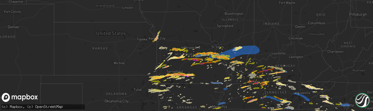
Hail Map in Missouri on May 8, 2024
The weather event in Missouri on May 8, 2024 includes Hail, Wind, and Tornado maps. 21 states and 1,905 cities were impacted and suffered possible damage. The total estimated number of properties impacted is 248,663.
Hail
Wind
Tornado
248,663
Estimated number of impacted properties by a 1.00" hail or larger107,216
Estimated number of impacted properties by a 1.75" hail or larger49,779
Estimated number of impacted properties by a 2.50" hail or largerStorm reports in Missouri
Missouri
| Date | Description |
|---|---|
| 05/08/20246:56 PM CDT | Mping report of quarter sized hail. |
| 05/08/20246:48 PM CDT | Corrects previous hail report from 4 e farmington. Social media report with photo. Time/location approximate... Augmented using radar. |
| 05/08/20246:48 PM CDT | Corrects previous report from 4 e farmington. Social media report with photo. Time approximate... Augmented using radar. |
| 05/08/20246:42 PM CDT | Penny to half dollar sized hail in farmington. |
| 05/08/20246:38 PM CDT | A local report indicates 1.00 inch wind near Mansfield |
| 05/08/20246:38 PM CDT | Report from mping: quarter |
| 05/08/20246:36 PM CDT | A local report indicates 2.75 inch wind near 4 NNE Ava |
| 05/08/20246:36 PM CDT | A local report indicates 2.75 inch wind near 4 NNE Ava |
| 05/08/20246:34 PM CDT | Fire department and police reports lots of hail about 2 in in ava. |
| 05/08/20246:34 PM CDT | Picture via email. Time estimated from radar. |
| 05/08/20246:30 PM CDT | Via social media picture. Delayed report. |
| 05/08/20246:30 PM CDT | Via social media picture. |
| 05/08/20246:30 PM CDT | Picture via email. Time estimated from radar. |
| 05/08/20246:30 PM CDT | Delayed report. |
| 05/08/20246:23 PM CDT | Report from mping... Quarter. |
| 05/08/20246:20 PM CDT | Picture of hail via contact. |
| 05/08/20246:18 PM CDT | Report from mping... Quarter 1.00 in. Time based on radar. |
| 05/08/20246:17 PM CDT | Report from mping: half dollar |
| 05/08/20246:16 PM CDT | A local report indicates 1.75 inch wind near 3 SSW Mansfield |
| 05/08/20246:16 PM CDT | Widespread power outage in ste gen and in surrounding areas. Lots of small limbs down .. |
| 05/08/20246:12 PM CDT | A local report indicates 2.75 inch wind near 2 SE Dogwood |
| 05/08/20246:07 PM CDT | Media reports 60 to 70 mph wind gust in bloomsdale. |
| 05/08/20246:06 PM CDT | Corrects previous non-tstm wnd dmg report from 2 ssw mineral point. Tree down blocking road at new diggins rd and cook subdivision rd. |
| 05/08/20246:06 PM CDT | Report from mping... Quarter size. Time based on radar. |
| 05/08/20246:05 PM CDT | Reported via weather net: quarter sized hail. |
| 05/08/20246:05 PM CDT | Large trees down in bloomsdale. One tree is on a house. |
| 05/08/20246:05 PM CDT | Delayed report. Lasted 2 to 3 minutes. |
| 05/08/20246:00 PM CDT | A local report indicates 1.25 inch wind near Rogersville |
| 05/08/20246:00 PM CDT | Hail quarter to half dollar size hail in rogersville vv and watts road. |
| 05/08/20246:00 PM CDT | Via social media picture. |
| 05/08/20245:56 PM CDT | A local report indicates 1.50 inch wind near 4 NNE Sparta |
| 05/08/20245:54 PM CDT | A local report indicates 1.75 inch wind near 1 N Oldfield |
| 05/08/20245:53 PM CDT | Tree down over the road. |
| 05/08/20245:52 PM CDT | Hail in sparta has increased to ping pong ball size and increased in heavy winds. |
| 05/08/20245:48 PM CDT | Report from mping: quarter 1.00 in. |
| 05/08/20245:48 PM CDT | Report from mping... Quarter. Time based on radar. |
| 05/08/20245:48 PM CDT | Via social media pic. Post reported it fell around 5 pm but radar shows 548 pm. |
| 05/08/20245:48 PM CDT | Report from mping: quarter 1.00 in. |
| 05/08/20245:42 PM CDT | Time based on radar. |
| 05/08/20245:40 PM CDT | Report from mping... 1-inch tree limbs broken... Shingles blown off. |
| 05/08/20245:40 PM CDT | A local report indicates 1.50 inch wind near 1 NE Nixa |
| 05/08/20245:40 PM CDT | Via social media picture. |
| 05/08/20245:40 PM CDT | Via social media pics. |
| 05/08/20245:40 PM CDT | Delayed report. |
| 05/08/20245:37 PM CDT | Hail rapidly changed from quarter to golf ball sized hail. |
| 05/08/20245:36 PM CDT | Report from mping... Hen egg 2.25 in. |
| 05/08/20245:36 PM CDT | A local report indicates 2.50 inch wind near 1 S Nixa |
| 05/08/20245:36 PM CDT | A local report indicates 1.50 inch wind near 2 W Ozark |
| 05/08/20245:35 PM CDT | Report from mping... Ping pong ball 1.50 in. |
| 05/08/20245:35 PM CDT | Quarters in potosi. |
| 05/08/20245:35 PM CDT | Report from mping... Quarter 1.00 in. |
| 05/08/20245:34 PM CDT | A local report indicates 2.00 inch wind near 1 S Nixa |
| 05/08/20245:34 PM CDT | A local report indicates 1.75 inch wind near 1 SSW Nixa |
| 05/08/20245:33 PM CDT | A local report indicates 2.00 inch wind near 2 S Nixa |
| 05/08/20245:31 PM CDT | Dime to quarter size hail 3 west of noel on highway 90 reported by fire. |
| 05/08/20245:31 PM CDT | Quarter size hail - gregg rd 1 miles south of hwy 14 on the west side of nixa. Also reported at mathews elementary. |
| 05/08/20245:31 PM CDT | Via social media picture. |
| 05/08/20245:28 PM CDT | Report from mping trees uprooted or snapped... Roof blown off. Time based on radar. |
| 05/08/20245:26 PM CDT | Report from mping... Quarter 1.00 in. |
| 05/08/20245:24 PM CDT | Time based on radar. |
| 05/08/20245:20 PM CDT | Report of quarter sized hail 9 wsw potosi. |
| 05/08/20245:18 PM CDT | A local report indicates 1.75 inch wind near 2 N Clever |
| 05/08/20245:12 PM CDT | Via social media pic. |
| 05/08/20245:08 PM CDT | Quarter sized hail at correctional facility in hillsboro. |
| 05/08/20245:05 PM CDT | A local report indicates 1.00 inch wind near El Dorado Springs |
| 05/08/20245:04 PM CDT | Spotter in marionville reporting golf ball size hail. |
| 05/08/20245:00 PM CDT | Marionville. 1700 hours. 1.5 - 2 inches. Via social media. |
| 05/08/20244:57 PM CDT | Report from mping... Quarter 1.00 in. |
| 05/08/20244:56 PM CDT | Report from mping... Half dollar 1.25 in. |
| 05/08/20244:56 PM CDT | Per dispatch... Caller reports golf ball sized hail in billings. |
| 05/08/20244:52 PM CDT | Powerlines down 60 and chappell rd... Monett. |
| 05/08/20244:51 PM CDT | 60/ western in marionville for golf ball sized hail. |
| 05/08/20244:48 PM CDT | Hail from 1 to 2 inches. Time based on radar. |
| 05/08/20244:47 PM CDT | Report from mping quarter 1.00 in. |
| 05/08/20244:45 PM CDT | Trees down 2230/1180 in aurora. Time based on rafar. |
| 05/08/20244:45 PM CDT | Report of golf ball size hail in aurora. Time based on radar. |
| 05/08/20244:45 PM CDT | Delayed report. |
| 05/08/20244:42 PM CDT | Report from mping... Homes... Buildings completely destroyed. Delayed report. Time based on radar. |
| 05/08/20244:40 PM CDT | Report from mping... Homes... Buildings completely destroyed. Time based on radar not time of report filed. |
| 05/08/20244:40 PM CDT | Delayed report of 1 to 1.5 inch hail around edgar springs. |
| 05/08/20244:35 PM CDT | Delayed report via social media of golf ball size hail. |
| 05/08/20244:34 PM CDT | Multiple trees down south of verona at farm road 5000 and farm road 1150. |
| 05/08/20244:30 PM CDT | Barn destroyed 4 east of monett. Trees blocking road. Time based on radar.... |
| 05/08/20244:30 PM CDT | Another barn destroyed... 18 wheeler trailer only... Flipped also east of monett. Time based on radar. |
| 05/08/20244:28 PM CDT | Multiple reports of a tornado in the monett area... Including trees down. |
| 05/08/20244:28 PM CDT | Multiple reports of a tornado in the monett ar |
| 05/08/20244:28 PM CDT | Multiple reports of a to |
| 05/08/20244:25 PM CDT | A local report indicates 1.25 inch wind near Rolla |
| 05/08/20244:25 PM CDT | A nws survey team confirmed that an ef-1 tornado occurred southeast of monett in northern barry county and tracked northeast into southern lawrence county before liftin |
| 05/08/20244:24 PM CDT | Report from mping... Ping pong ball 1.50 in. |
| 05/08/20244:24 PM CDT | Damage in monett. Mcdonald’s sign blown out. Debris landing on 60 west of town damage landed on spotters car... Could not tell the origin. |
| 05/08/20244:24 PM CDT | Report of large tree down east of the hospital south side of 60 hwy. |
| 05/08/20244:24 PM CDT | Report from mping... Quarter 1.00 in. Time based on radar. |
| 05/08/20244:24 PM CDT | Damage in monett. Mcdonaldâs sign blown out. Debris landing on 60 west of town damage landed on spotters car... Could not tell the origin. |
| 05/08/20244:15 PM CDT | A local report indicates 1.00 inch wind near 1 S Neosho |
| 05/08/20244:13 PM CDT | Via social media. |
| 05/08/20244:12 PM CDT | Report from mping... Golf ball 1.75 in. |
| 05/08/20244:12 PM CDT | A local report indicates 1.25 inch wind near 5 S Racine |
| 05/08/20244:12 PM CDT | Report from mping... Golf ball |
| 05/08/20244:09 PM CDT | Just over 1 inch size hail... Just west of rolla. |
| 05/08/20244:06 PM CDT | Major hail damage to cars... Roofs... Etc. |
| 05/08/20244:02 PM CDT | Via social media picture. |
| 05/08/20244:00 PM CDT | Unconfirmed social media report of half dollar sized hail 3 miles south of seneca on missouri highway 43 in newton county at 4 pm. |
| 05/08/20243:56 PM CDT | Camdenton north hwy 5 and old hwy 5 at the ozark amphitheater. |
| 05/08/20243:56 PM CDT | Lake regional clinic north highway 5 camdenton. |
| 05/08/20243:54 PM CDT | Report from mping... Half dollar 1.25 in. |
| 05/08/20243:54 PM CDT | Report from mping... Golf ball 1.75 in. |
| 05/08/20243:51 PM CDT | Between golf ball and tennis ball. Via social media pic. |
| 05/08/20243:50 PM CDT | Report from mping 3-inch tree limbs broken... Power poles broken. |
| 05/08/20243:50 PM CDT | Via social media. |
| 05/08/20243:49 PM CDT | A local report indicates 1.00 inch wind near Neosho |
| 05/08/20243:40 PM CDT | North of town on carnahan dr. |
| 05/08/20243:36 PM CDT | Report from mping... Homes... Buildings completely destroyed. Time based on radar. Reported at 723 pm. |
| 05/08/20243:30 PM CDT | Via social media picture. Stated they were located 10 min north of greenfield. |
| 05/08/20243:28 PM CDT | Report relayed through media. |
| 05/08/20243:24 PM CDT | A local report indicates 1.75 inch wind near Seneca |
| 05/08/20243:12 PM CDT | Trained spotter quarter sized hail north of cross timbers at lucas ranch headquarters in hickory county. |
| 05/08/20243:12 PM CDT | Time based on radar. |
| 05/08/20243:10 PM CDT | 1 inch hail in hermitage in hickory county. |
| 05/08/20243:10 PM CDT | Delayed report. |
| 05/08/20243:06 PM CDT | Via social media. |
| 05/08/20242:58 PM CDT | 20th and central. |
| 05/08/20242:48 PM CDT | A local report indicates 1.00 inch wind near 1 WSW Quincy |
| 05/08/20242:48 PM CDT | Hwy e near eldridge. |
| 05/08/20242:48 PM CDT | Hwy e near eldridge. 833 |
| 05/08/20242:35 PM CDT | A local report indicates 1.50 inch wind near 1 SW Gerster |
| 05/08/20242:32 PM CDT | Report from mping quarter 1.00 in. |
| 05/08/20242:25 PM CDT | Quarter sized hail in farmington pictured next to quarter. |
| 05/08/20242:06 PM CDT | Via twitter: size estimated from picture. |
| 05/08/20242:06 PM CDT | Via facebook. Picture of measured hailstone. |
| 05/08/20242:06 PM CDT | Corrects previous hail report from ste. Genevieve. Via facebook. Picture of measured hailstone. |
| 05/08/20242:06 PM CDT | Corrects previous hail report from ste. Genevieve. Corrects previous hail report from ste. Genevieve. Via facebook. Picture of measured hailstone. |
| 05/08/20242:01 PM CDT | Report from mping: quarter |
| 05/08/20241:58 PM CDT | Multiple reports of golf ball sized hail in ste. Gen. |
| 05/08/20241:58 PM CDT | Trees down on hwy p and barbary road. |
| 05/08/20241:51 PM CDT | Report from mping: quarter |
| 05/08/20241:48 PM CDT | Half dollar sized hail at hwy m and east st. |
| 05/08/20241:46 PM CDT | Quarter to golf ball sized hail reported in leadwood. |
| 05/08/20241:45 PM CDT | Reported via facebook with picture. Time reported from public. |
| 05/08/20241:44 PM CDT | Golf ball sized hail in irondale. |
| 05/08/20241:44 PM CDT | Golf ball sized hail in irondale. |
| 05/08/20241:40 PM CDT | Quarter sized hail reported north of irondale at hwy u and savoy road. |
| 05/08/20241:32 PM CDT | Tree down over power lines on gilday road south of potosi. Time estimated from radar. |
| 05/08/20241:25 PM CDT | Measured 2 to 2.5 inch hailstones. |
| 05/08/20241:19 PM CDT | Large tree uprooted in festus. Roots snap just below surface. |
| 05/08/20241:18 PM CDT | Social media photo of ping pong ball sized hail in horine... Mo. Time estimated from radar. |
| 05/08/20241:18 PM CDT | 1ft tree limb down in yard. Time estimated by radar. |
| 05/08/20241:16 PM CDT | Social media photo of ping pong ball sized hail. |
| 05/08/20241:15 PM CDT | Multiple reports of ping pong to golf ball sized hail from media... Emergency manager... And fire department. |
| 05/08/20241:14 PM CDT | Via facebook: golf ball sized hail estimated from picture. |
| 05/08/20241:14 PM CDT | Size estimated against a quarter. |
| 05/08/20241:14 PM CDT | Public report of quarter to half dollar sized hail. |
| 05/08/20241:13 PM CDT | Nickel to quarter sized hail. |
| 05/08/20241:11 PM CDT | Reports of golf ball to tennis ball sized hail in festus. |
| 05/08/20241:11 PM CDT | Report from mping: hen egg+ |
| 05/08/20241:10 PM CDT | Golf ball sized hail in herculaneum. |
| 05/08/20241:09 PM CDT | Relayed from amateur radio: golf ball sized hail reported. |
| 05/08/20241:09 PM CDT | Time estimated from radar. Social media photo showed approximately two inch hail. |
| 05/08/20241:02 PM CDT | Half dollar sized hail 3 se hematite. Time estimated from radar. |
| 05/08/20241:02 PM CDT | Up to golf ball sized hail measured. |
| 05/08/202412:54 PM CDT | Via twitter: report of baseball sized hail time estimated from radar. |
| 05/08/202412:54 PM CDT | Quarter sized hail estimated from picture. |
| 05/08/202412:54 PM CDT | Via twitter: size estimated from picture and time estimated from radar. |
| 05/08/202412:52 PM CDT | Trooper reports golf ball to baseball sized hail in hillsboro. |
| 05/08/202412:47 PM CDT | Golf ball sized hail at dittmer ridge road and hwy 30. |
| 05/08/202412:47 PM CDT | Golf ball sized hail at dittmer ridge road and hwy 30. |
| 05/08/202412:43 PM CDT | A local report indicates 1.00 inch wind near 2 ENE Morse Mill |
| 05/08/202412:31 PM CDT | Media relaying reports: baseball sized hail being reported west of hillsboro. |
| 05/08/202412:31 PM CDT | Nickel to quarter sized hail. |
| 05/08/202412:20 PM CDT | Quarter sized hail. |
| 05/08/202411:48 AM CDT | Marble to golf ball sized hail. Drifts of small hail with piles 10-12 inches deep. Stripped vegetation. |
| 05/08/202411:45 AM CDT | Meramec state park receiving quarter to golf ball sized hail. Relayed from park ranger. |
| 05/08/202411:42 AM CDT | Gas station attendant reported quarter sized hail. Time estimated from radar. |
| 05/08/202411:40 AM CDT | Quarter sized hail on i-44 eb at mm 232. |
| 05/08/202411:39 AM CDT | Relayed report of golf ball sized hail in sullivan. |
| 05/08/202411:33 AM CDT | Corrects previous tstm wnd dmg report from 1 e sullivan. Large tree snapped at base and tree branches down in sullivan. |
| 05/08/202411:08 AM CDT | Quarter sized hail. Time estimated from radar. |
| 05/08/202411:04 AM CDT | Corrects previous tornado report from 6 sw oak hill. An ef-1 tornado with peak winds of 95 mph touched down along jakes prairie road northwest of cuba. The tornado trac |
| 05/08/202410:40 AM CDT | The kvih aos recorded a 67 mph wind gust. |
| 05/08/202410:40 AM CDT | Delayed report of a tree down off highway 28 south of belle. |
| 05/08/20249:48 AM CDT | A local report indicates 1.00 inch wind near 3 ESE Etterville |
| 05/08/20249:42 AM CDT | A local report indicates 1.00 inch wind near Marys Home |
| 05/08/20249:35 AM CDT | High winds pushed in a large double garage door on an outbuilding. |
| 05/08/20249:33 AM CDT | A local report indicates 1.00 inch wind near Eugene |
| 05/08/20249:19 AM CDT | A local report indicates 1.00 inch wind near Versailles |
| 05/08/20249:18 AM CDT | A local report indicates 1.00 inch wind near High Point |
| 05/08/20249:15 AM CDT | A local report indicates 1.25 inch wind near 3 SE Versailles |
| 05/08/20249:08 AM CDT | A local report indicates 1.00 inch wind near Stover |
| 05/08/20248:51 AM CDT | A local report indicates 1.75 inch wind near 2 SE Cole Camp |
| 05/08/20248:47 AM CDT | Also reported torrential rainfall with rates near 7 inches per hour. |
| 05/08/20248:45 AM CDT | Sgf received report of tennis ball sized hail. Time estimated from radar. |
| 05/08/20248:43 AM CDT | A local report indicates 1.00 inch wind near Ionia |
| 05/08/20248:38 AM CDT | Quarter size hail near route zz. Time estimated from radar. |
| 05/08/20248:38 AM CDT | Quarter size hail near route zz. Time estimated from radar. |
| 05/08/20248:00 AM CDT | Downed wires and power outages near 1200th road. Time estimated from radar. |
| 05/08/20247:35 AM CDT | Report from mping: quarter |
| 05/08/20247:35 AM CDT | Report from mping: quarter |
| 05/08/20247:35 AM CDT | Reported in gladstone. |
| 05/08/20247:33 AM CDT | Social media report. Time estimated from radar. |
| 05/08/20247:29 AM CDT | Report from mping: ping pong ball |
| 05/08/20247:29 AM CDT | Report from mping: quarter |
| 05/08/20247:24 AM CDT | Time estimated from radar. |
| 05/08/20247:24 AM CDT | Social media report. Time estimated from radar. |
| 05/08/20247:23 AM CDT | Report from mping: quarter |
| 05/08/20247:20 AM CDT | Report from mping: quarter |
| 05/08/20247:19 AM CDT | Social media report. |
| 05/08/20247:18 AM CDT | Report from mping: quarter |
| 05/08/20247:18 AM CDT | Reported by wdaf. |
| 05/08/20247:17 AM CDT | Social media report. |
| 05/08/20247:17 AM CDT | Report from mping: quarter |
| 05/08/20247:15 AM CDT | Report from mping: quarter |
| 05/08/20247:15 AM CDT | A local report indicates 1.00 inch wind near 1 SSW Kansas City |
| 05/08/20247:13 AM CDT | Time confirmed by radar. |
| 05/08/20247:10 AM CDT | Downed wires and power outages near truman road. Time estimated from radar. |
| 05/08/20247:10 AM CDT | Corrects previous tstm wnd dmg report from archie. Downed trees and wires and power outages near truman road. Time estimated from radar. |
| 05/08/20247:08 AM CDT | Delayed report... Max size 1.50 inches... Hail covered the ground. |
| 05/08/20247:04 AM CDT | A local report indicates 1.00 inch wind near 6 S Harrisonville |
| 05/07/202411:45 PM CDT | Trees and power lines down across caruthersville. |
| 05/07/202411:15 PM CDT | Awos station kmaw malden. |
| 05/07/202411:11 PM CDT | Large tree down on patty lynn drive. Time is radar estimated. |
| 05/07/202411:10 PM CDT | Several tree tops removed and a couple of uprooted trees on falcon drive in kennett. Time is radar estimated. |
| 05/07/202410:45 PM CDT | Report from mping: trees uprooted or snapped. |
| 05/07/202410:20 PM CDT | A local report indicates 1.00 inch wind near East Prairie |
| 05/07/202410:00 PM CDT | Tree damage... Damage to power lines. |
| 05/07/20249:44 PM CDT | Report from mping of ping pong ball |
| 05/07/20249:30 PM CDT | Picture of a 6 to 10 inch limb snapped off of a tree. |
| 05/07/20249:15 PM CDT | Trees and lines down near dear run lake. Time estimated from radar. |
| 05/07/20249:15 PM CDT | Trees and lines down near dear ru |
| 05/07/20249:10 PM CDT | Via subreddit. Large tree of unknown health fallen in fredericktown. |
| 05/07/20249:08 PM CDT | Numerous reports of power outages in fredericktown. |
| 05/07/20249:06 PM CDT | An ef-0 tornado with peak winds of 85 mph touched down along madison county road 503 north of the intersection with madison county road 505... Just to the west of frede |
| 05/07/20249:01 PM CDT | An ef-1 tornado with max winds of 94mph touched down in arcadia... Mo causing damage to trees and a few structures. It tracked east and lifted about 5 minutes later 12 |
| 05/07/20249:01 PM CDT | Corrects previous tornado report from arcadia. An ef-1 tornado with peak winds of 93 mph touched down in arcadia... Mo and tracked east for two minutes before lifting w |
| 05/07/20248:53 PM CDT | A tornado touched down 4 miles north-northeast of des arc... Mo and tracked east-northeast before lifting roughly 1.5 miles away. |
| 05/07/20248:50 PM CDT | A brief ef-0 with maximum winds of 85 mph touched down southeast of annapolis... Causing tree damage for two minutes. |
| 05/07/20248:49 PM CDT | Trees down and debris off hwy k near annapolis. |
| 05/07/20248:49 PM CDT | Heavy tree damage and part of a school roof missing. |
| 05/07/20248:49 PM CDT | Report of power loss in annapolis. Exact cause unknown at this time. |
| 05/07/20248:49 PM CDT | An ef1 tornado with estimated peak winds of 110 mph touched down at the eastern extent of annapolis... Mo at 8:49 pm. The tornado tracked east-northeast directly throug |
| 05/07/20248:49 PM CDT | Corrects previous tornado report from annapolis. An ef1 tornado with estimated peak winds of 110 mph touched down at the western extent of annapolis... Mo at 8:49 pm. T |
| 05/07/20248:49 PM CDT | An ef-1 tornado with peak winds of 110mph touched down west of annapolis... Tracking east through the city and damaging several trees and a school. The tornado lifted t |
| 05/07/20248:46 PM CDT | Widespread tree damage reported by em. Time estimated from radar. |
| 05/07/20248:44 PM CDT | An ef1 tornado with peak winds of 93mph touched down 5 miles southwest of annapolis and tracked east-northeast to southwest madison county before lifting... Lasting for |
| 05/07/20248:10 PM CDT | Many trees and limbs down making roads impassable. Time estimated from radar. |
| 05/07/20247:49 PM CDT | Via social media picture. |
| 05/07/20247:35 PM CDT | Ping pong ball size hail in willow springs... Howell county... Per spotter. |
| 05/07/20247:35 PM CDT | Report from mping... Ping pong ball 1.50 in. |
| 05/07/20247:32 PM CDT | Quarter size hail in willow springs... Howell county... Per spotter. |
| 05/07/20247:30 PM CDT | Via social media. |
| 05/07/20247:25 PM CDT | There are reports of golf ball size hail 6 miles west of willow springs per a weather spotter. Time based on radar. |
| 05/07/20247:12 PM CDT | Report from mping... Trees uprooted or snapped... Roof blown off. Tie based on radar not report time of 8:59 pm. |
| 05/07/20247:06 PM CDT | The fire department reported 18 in di tress down across 95 why in drury. Time based on radar. |
| 05/07/20247:06 PM CDT | Report from mping... Trees uprooted or snapped... Roof blown off. Time based on radar not report time. |
| 05/07/20247:05 PM CDT | Report from mping... Quarter 1.00 in. |
| 05/07/20247:05 PM CDT | Spotter reports golf ball size hail in vanzant on st hwy 95 and hwy 76 with 60 mph winds. |
| 05/07/20247:03 PM CDT | Baseball size hail reported by vanzant and 76 highway. Reported by fire department. |
All States Impacted by Hail Map on May 8, 2024
Cities Impacted by Hail Map on May 8, 2024
- Hot Springs National Park, AR
- Little Rock, AR
- Scott, AR
- North Little Rock, AR
- Lonoke, AR
- England, AR
- Carlisle, AR
- Hazen, AR
- Stuttgart, AR
- De Valls Bluff, AR
- Clarendon, AR
- Roe, AR
- Shawnee, KS
- Mission, KS
- Prairie Village, KS
- Overland Park, KS
- Kansas City, MO
- Kansas City, KS
- Hickman, KY
- Monticello, KY
- Joelton, TN
- Whites Creek, TN
- Lenexa, KS
- Lafayette, TN
- Red Boiling Springs, TN
- Garden City, MO
- Harrisonville, MO
- Mayfield, KY
- Leawood, KS
- Creighton, MO
- Archie, MO
- Albany, KY
- Olathe, KS
- Riverside, MO
- Liberty, MO
- Clinton, KY
- Whitleyville, TN
- Goodlettsville, TN
- Moss, TN
- Gainesboro, TN
- Blairstown, MO
- Urich, MO
- Independence, MO
- Celina, TN
- Pall Mall, TN
- Trimble, MO
- Holt, MO
- Smithville, MO
- Plattsburg, MO
- Kearney, MO
- Lathrop, MO
- Montrose, MO
- Chilhowee, MO
- Holden, MO
- Hilham, TN
- East Prairie, MO
- Clinton, MO
- Hendersonville, TN
- Benton, KY
- Symsonia, KY
- Hickory, KY
- Stearns, KY
- Rickman, TN
- Cookeville, TN
- Deepwater, MO
- Oneida, TN
- Calhoun, MO
- Monroe, TN
- Allons, TN
- Livingston, TN
- Calvert City, KY
- Windsor, MO
- Alpine, TN
- Paducah, KY
- Allred, TN
- Boaz, KY
- Wilder, TN
- Jamestown, TN
- Lincoln, MO
- Ledbetter, KY
- Smithland, KY
- Ionia, MO
- Green Ridge, MO
- Cole Camp, MO
- Sedalia, MO
- Mora, MO
- La Follette, TN
- White House, TN
- Speedwell, TN
- Duff, TN
- Deer Lodge, TN
- Allardt, TN
- Sunbright, TN
- Stover, MO
- Lancing, TN
- Robbins, TN
- Versailles, MO
- New Tazewell, TN
- Sharps Chapel, TN
- Florence, MO
- Maynardville, TN
- Barnett, MO
- Cottontown, TN
- Washburn, TN
- Springfield, TN
- Greenbrier, TN
- Madison, TN
- Tazewell, TN
- Osage Beach, MO
- Sunrise Beach, MO
- Eldon, MO
- Russellville, MO
- California, MO
- Rutledge, TN
- Kaiser, MO
- Monterey, TN
- Tuscumbia, MO
- Thorn Hill, TN
- Oakdale, TN
- Wartburg, TN
- Latham, MO
- Lake Ozark, MO
- Morristown, TN
- Bean Station, TN
- Talbott, TN
- Eugene, MO
- Ulman, MO
- Iberia, MO
- Henley, MO
- Olean, MO
- Rocky Mount, MO
- Clarkrange, TN
- Jefferson City, MO
- Russellville, TN
- Meta, MO
- Saint Thomas, MO
- Westphalia, MO
- Dixon, MO
- Crocker, MO
- Saint Elizabeth, MO
- Mooresburg, TN
- Brinktown, MO
- Whitesburg, TN
- Bulls Gap, TN
- Mohawk, TN
- Jefferson City, TN
- Vienna, MO
- Argyle, MO
- Midway, TN
- Mosheim, TN
- Greeneville, TN
- Vichy, MO
- Belle, MO
- Knoxville, TN
- Freeburg, MO
- Linn, MO
- Koeltztown, MO
- Saint James, MO
- Bland, MO
- Owensville, MO
- Strawberry Plains, TN
- New Market, TN
- Rolla, MO
- Cuba, MO
- Dandridge, TN
- Afton, TN
- Cape Girardeau, MO
- White Pine, TN
- Newport, TN
- Sullivan, MO
- Bourbon, MO
- Rosebud, MO
- Limestone, TN
- Chuckey, TN
- Seymour, TN
- Jonesboro, IL
- Telford, TN
- Bybee, TN
- Leasburg, MO
- Jonesborough, TN
- Cobden, IL
- Anna, IL
- Parrottsville, TN
- Sevierville, TN
- Del Rio, TN
- Gerald, MO
- Buncombe, IL
- Vienna, IL
- Rogersville, TN
- Saint Clair, MO
- Goreville, IL
- Cosby, TN
- Lonedell, MO
- Richwoods, MO
- Creal Springs, IL
- Marion, IL
- Marshall, NC
- Hot Springs, NC
- Cherokee, NC
- Leslie, MO
- Hartford, TN
- Mars Hill, NC
- Weaverville, NC
- Grubville, MO
- Dittmer, MO
- Luebbering, MO
- Mountain Rest, SC
- Flag Pond, TN
- Fletcher, MO
- Barnardsville, NC
- Robertsville, MO
- Leicester, NC
- Alexander, NC
- Tamassee, SC
- Salem, SC
- Hopkinsville, KY
- Hillsboro, MO
- De Soto, IL
- Elkville, IL
- Murphysboro, IL
- De Soto, MO
- Burnsville, NC
- Mulkeytown, IL
- Royalton, IL
- Pembroke, KY
- Elkton, KY
- Summer Shade, KY
- Glasgow, KY
- Scottsville, KY
- Cedar Hill, MO
- Blackwell, MO
- Potosi, MO
- Christopher, IL
- Buckner, IL
- Sunset, SC
- Pickens, SC
- Six Mile, SC
- Benton, IL
- Festus, MO
- Old Fort, NC
- Hendersonville, NC
- Fletcher, NC
- Arden, NC
- Fairview, NC
- Chetopa, KS
- Lewisburg, KY
- Sharon Grove, KY
- Robbinsville, NC
- Union Mills, NC
- Bartlett, KS
- Black Mountain, NC
- Lucas, KY
- Waynesville, NC
- Lake Junaluska, NC
- Nevada, MO
- Clyde, NC
- Pevely, MO
- Herculaneum, MO
- Crystal City, MO
- Russellville, KY
- Oswego, KS
- House Springs, MO
- Drakesboro, KY
- Central City, KY
- Walker, MO
- Marion, NC
- Asheville, NC
- Beaver Dam, KY
- Gerton, NC
- Mills River, NC
- Erwin, TN
- Cadet, MO
- Valmeyer, IL
- Barnhart, MO
- Lake Lure, NC
- Easley, SC
- Cromwell, KY
- Waterloo, IL
- Fults, IL
- Mill Spring, NC
- Rutherfordton, NC
- Horse Branch, KY
- Rosine, KY
- Greenville, SC
- Caledonia, MO
- Belgrade, MO
- Harwood, MO
- Valles Mines, MO
- French Village, MO
- Auburn, KY
- Bloomsdale, MO
- El Dorado Springs, MO
- Bryson City, NC
- Bonne Terre, MO
- Irondale, MO
- Mineral Point, MO
- Bismarck, MO
- Park Hills, MO
- Franklin, NC
- Olaton, KY
- Leadwood, MO
- Prairie Du Rocher, IL
- Marion, KY
- Salem, KY
- Bluejacket, OK
- Welch, OK
- Nebo, NC
- Liberal, MO
- Oronogo, MO
- Jasper, MO
- Cullowhee, NC
- Schell City, MO
- Princeton, KY
- Dawson Springs, KY
- Morgantown, KY
- Rockfield, KY
- Sainte Genevieve, MO
- Sylva, NC
- Whittier, NC
- Saint Charles, KY
- Nortonville, KY
- Evansville, IL
- Modoc, IL
- Ellis Grove, IL
- Tyringham, MA
- Otis, MA
- Monterey, MA
- Blandford, MA
- East Otis, MA
- Great Barrington, MA
- Sheffield, MA
- South Egremont, MA
- Lamar, MO
- Caneyville, KY
- Falls Of Rough, KY
- Fredonia, KY
- Forest City, NC
- Spindale, NC
- Topton, NC
- Bowling Green, KY
- Bostic, NC
- Red Bud, IL
- Ellenboro, NC
- Walsh, IL
- Madisonville, KY
- Mortons Gap, KY
- White Plains, KY
- Graham, KY
- Sandisfield, MA
- Crofton, KY
- Chester, IL
- Farmington, MO
- Sturgis, KY
- Puryear, TN
- Hampton, KY
- Miami, OK
- Clay, KY
- Lawndale, NC
- Shelby, NC
- Tiptonville, TN
- Hornbeak, TN
- Butler, MO
- Appleton City, MO
- Nashville, TN
- Ashland City, TN
- Russell, MA
- Granville, MA
- Greenville, KY
- Osceola, MO
- Collins, MO
- Sparta, IL
- Mooresboro, NC
- Huntington, MA
- Westfield, MA
- Southampton, MA
- Tuckasegee, NC
- Pleasant View, TN
- Stockton, MO
- North Miami, OK
- Adams, TN
- Cedar Hill, TN
- Quapaw, OK
- Commerce, OK
- Beech Creek, KY
- Smiths Grove, KY
- Oakland, KY
- Simpsonville, SC
- Woodruff, SC
- Greer, SC
- Old Hickory, TN
- Vinita, OK
- Clarksville, TN
- Troy, TN
- Saint Mary, MO
- Ironton, MO
- Doe Run, MO
- Kings Mountain, NC
- Cherryville, NC
- Bessemer City, NC
- Holyoke, MA
- West Springfield, MA
- Chicopee, MA
- Afton, OK
- Beechmont, KY
- Jerico Springs, MO
- Lockwood, MO
- Browder, KY
- Belton, KY
- Arcola, MO
- Quincy, MO
- Weaubleau, MO
- Hazel, KY
- New Concord, KY
- Murray, KY
- Rosman, NC
- Balsam Grove, NC
- Lake Toxaway, NC
- Park City, KY
- Rocky Hill, KY
- Morganfield, KY
- Fountain Inn, SC
- Providence, KY
- Nebo, KY
- Amherst, MA
- Hadley, MA
- Northampton, MA
- Buchanan, TN
- Crouse, NC
- Elizabethtown, IL
- Cave In Rock, IL
- Eldridge, MO
- Melber, KY
- Union City, TN
- Steeleville, IL
- Rosiclare, IL
- Percy, IL
- Camdenton, MO
- Lebanon, MO
- Stoutland, MO
- Montreal, MO
- Roebuck, SC
- Pauline, SC
- Petersham, MA
- Enoree, SC
- Dallas, NC
- Cave City, KY
- Gastonia, NC
- Campbell Hill, IL
- Ava, IL
- Horse Cave, KY
- Coulterville, IL
- Cutler, IL
- Pinckneyville, IL
- Wheatland, MO
- Lincolnton, NC
- Manitou, KY
- Rochester, KY
- Fairland, OK
- Mauldin, SC
- Waverly, KY
- Wyandotte, OK
- Shutesbury, MA
- Carbondale, IL
- Fulton, KY
- South Fulton, TN
- Greenfield, TN
- Ludlow, MA
- Springfield, MA
- Indian Orchard, MA
- Wilbraham, MA
- Corydon, KY
- Gaffney, SC
- Ullin, IL
- Grand Chain, IL
- Karnak, IL
- Martin, TN
- Golden City, MO
- Austin, KY
- Pomona, IL
- Magnolia, MN
- Kanaranzi, MN
- Fredericktown, MO
- Rockwood, IL
- Athol, MA
- Templeton, MA
- Hubbardston, MA
- Gardner, MA
- Barre, MA
- Buffalo, SC
- Jonesville, SC
- Hardyville, KY
- Center, KY
- Uniontown, KY
- Kenneth, MN
- Cross Timbers, MO
- Hermitage, MO
- Cross Plains, TN
- Vergennes, IL
- Robards, KY
- Sebree, KY
- Hanson, KY
- Chatham, VA
- Brookport, IL
- Seneca, MO
- Neosho, MO
- Joplin, MO
- Dover, TN
- Knob Lick, KY
- Union, SC
- Monson, MA
- Palmer, MA
- Mount Holly, NC
- Gilbertsville, KY
- Reagan, TN
- Jacks Creek, TN
- Lexington, TN
- Huron, TN
- Perryville, MO
- Palmersville, TN
- Dresden, TN
- Luverne, MN
- Gleason, TN
- McKenzie, TN
- Columbus, KS
- New Haven, MO
- Richland, MO
- Greenfield, MO
- Blacksburg, SC
- Belknap, IL
- Dixon, KY
- Smyrna, SC
- Henderson, KY
- Sacramento, KY
- Big Rock, TN
- Cottage Grove, TN
- Slaughters, KY
- Weir, KS
- Paris, TN
- Lowell, NC
- Cramerton, NC
- Charlotte, NC
- McAdenville, NC
- Belmont, NC
- Stanley, NC
- Bumpus Mills, TN
- Three Rivers, MA
- Edwards, MO
- Warsaw, MO
- Preston, MO
- Matthews, NC
- Du Quoin, IL
- Jetson, KY
- Brownsville, KY
- Roundhill, KY
- Westminster, MA
- Wales, MA
- Henry, TN
- Dadeville, MO
- Rumsey, KY
- Scotts Hill, TN
- Sturbridge, MA
- Brimfield, MA
- Fiskdale, MA
- Hardin, KY
- Orlinda, TN
- Mount Vernon, IN
- Island, KY
- East Longmeadow, MA
- Hampden, MA
- Charlton, MA
- Holland, MA
- Edmonton, KY
- Gretna, VA
- Cadiz, KY
- York, SC
- Clover, SC
- Energy, IL
- Carterville, IL
- Herrin, IL
- Munfordville, KY
- Stafford Springs, CT
- Southbridge, MA
- Dudley, MA
- Chelsea, OK
- Dukedom, TN
- Grand Rivers, KY
- North Grosvenordale, CT
- Quinebaug, CT
- Woodstock Valley, CT
- Eastford, CT
- Pomfret Center, CT
- Woodstock, CT
- Greensburg, KY
- Concord, NC
- Midland, NC
- Harrisburg, NC
- Waynesville, MO
- Portland, TN
- Macks Creek, MO
- Climax Springs, MO
- Roach, MO
- Granby, MO
- Parsons, TN
- Decaturville, TN
- Darden, TN
- Cumberland City, TN
- Indian Mound, TN
- Livermore, KY
- Calhoun, KY
- Centertown, KY
- Dunmor, KY
- Fort Campbell, KY
- Woodlawn, TN
- Shoals, IN
- Almo, KY
- Monroe, NC
- Indian Trail, NC
- Golconda, IL
- Eddyville, IL
- Simpson, IL
- Adair, OK
- Dowell, IL
- Johnston City, IL
- Big Cabin, OK
- Mansfield, TN
- Pittsburg, IL
- Linden, TN
- Herndon, KY
- La Fayette, KY
- Newburg, MO
- Jerome, MO
- Springville, TN
- Linn Creek, MO
- Pierce City, MO
- Hartford, KY
- Stark City, MO
- Utica, KY
- Woodlawn, IL
- New Athens, IL
- Hecker, IL
- Addieville, IL
- Nashville, IL
- Lenzburg, IL
- Richview, IL
- Brumley, MO
- Ashley, IL
- Mount Vernon, IL
- Williams, IN
- Palmyra, TN
- Cunningham, TN
- Bee Spring, KY
- Leitchfield, KY
- Herod, IL
- Carlisle, SC
- Putnam, CT
- Thompson, CT
- Saint Robert, MO
- New Salem, IL
- Oxford, MA
- Webster, MA
- Ashford, CT
- Columbia, KY
- Campbellsville, KY
- Thompsonville, IL
- Clear Lake, SD
- Brandt, SD
- Stanfield, NC
- Big Sandy, TN
- Carrier Mills, IL
- Waynesboro, TN
- Clifton, TN
- Bath Springs, TN
- Makanda, IL
- Canby, MN
- Stewart, TN
- Beaufort, MO
- Clarkson, KY
- Cub Run, KY
- Goodman, MO
- Monett, MO
- Wentworth, MO
- Lobelville, TN
- Harrisburg, IL
- Mammoth Cave, KY
- Chester, SC
- Lunenburg, VA
- Victoria, VA
- Keysville, VA
- Galatia, IL
- Lometa, TX
- Fordsville, KY
- Dundee, KY
- Remsen, IA
- Marcus, IA
- Dayville, CT
- Chepachet, RI
- Westmoreland, TN
- Bethpage, TN
- Oak Grove, KY
- Maxton, NC
- Rowland, NC
- West Frankfort, IL
- Eddyville, KY
- Knifley, KY
- Junction, IL
- Stonefort, IL
- Alto Pass, IL
- Mindenmines, MO
- Marshville, NC
- Wingate, NC
- Gary, SD
- Pittsburg, KS
- Hohenwald, TN
- Oakboro, NC
- Lampasas, TX
- Opolis, KS
- Asbury, MO
- Licking, MO
- Duke, MO
- Pembroke, NC
- Eldorado, IL
- Verona, MO
- Centerville, TN
- Salem, MO
- Kenbridge, VA
- Cherryville, MO
- Waverly, TN
- Peachland, NC
- Lancaster, SC
- McEwen, TN
- Gravois Mills, MO
- Pryor, OK
- Trenton, KY
- Equality, IL
- Tennessee Ridge, TN
- Bonnieville, KY
- Taylors, SC
- Polkton, NC
- Grove, OK
- Cook Sta, MO
- Steelville, MO
- Roby, MO
- Beulah, MO
- Danielson, CT
- Adolphus, KY
- Anderson, MO
- Erin, TN
- Magnolia, KY
- Upton, KY
- Clarkton, NC
- Council, NC
- Norris City, IL
- Burna, KY
- Nunnelly, TN
- Liberty, KY
- Dunnville, KY
- Millwood, KY
- Wadesboro, NC
- Mount Vernon, MO
- Freistatt, MO
- Aurora, MO
- Guthrie, KY
- Fairmont, NC
- Lumberton, NC
- Sheldon, MO
- Bronaugh, MO
- Strang, OK
- Devils Elbow, MO
- Diamond, MO
- Ridgway, IL
- Shawneetown, IL
- Cumberland Furnace, TN
- Vanleer, TN
- Dickson, TN
- Charlotte, TN
- Marionville, MO
- Hampshire, TN
- Mount Pleasant, TN
- Billings, MO
- Crane, MO
- Clever, MO
- Edgar Springs, MO
- Lenox, MO
- Sneedville, TN
- Tiff City, MO
- Summertown, TN
- Orrum, NC
- Copperas Cove, TX
- Bon Aqua, TN
- Holland, KY
- Summersville, KY
- Carmi, IL
- Gatesville, TX
- Chapmansboro, TN
- Eucha, OK
- Milo, MO
- Fountain Run, KY
- Cassatt, SC
- Bishopville, SC
- Big Clifty, KY
- Monroe City, MO
- Palmyra, MO
- Brooklyn, CT
- Gamaliel, KY
- Mount Sherman, KY
- Fairview, MO
- Rocky Comfort, MO
- Stella, MO
- White Bluff, TN
- Bladenboro, NC
- Spavinaw, OK
- Riegelwood, NC
- Jay, OK
- Grantsburg, IL
- Kingston Springs, TN
- South West City, MO
- Noel, MO
- Davisville, MO
- Columbia, IL
- Holladay, TN
- Duck River, TN
- Sonora, KY
- White Mills, KY
- Buffalo, KY
- Tompkinsville, KY
- Mount Hermon, KY
- East Killingly, CT
- Foster, RI
- Sterling, CT
- Boss, MO
- Clayville, RI
- Hope, RI
- Moosup, CT
- Kodak, TN
- Nixa, MO
- Purdy, MO
- Wheaton, MO
- Imperial, MO
- Patrick, SC
- Hartsville, SC
- Belleville, IL
- Lanagan, MO
- Pineville, MO
- Lebanon, KY
- Gradyville, KY
- Millstadt, IL
- Kelly, NC
- Columbia, TN
- Locust Grove, OK
- Pegram, TN
- Fontana Dam, NC
- Oliver Springs, TN
- Evergreen, NC
- Yosemite, KY
- Brookline, MO
- Springfield, MO
- Ozark, MO
- Highlandville, MO
- Gravette, AR
- Fairview Heights, IL
- O'Fallon, IL
- Spring Hill, TN
- Rose, OK
- Salina, OK
- Mannsville, KY
- Bradfordsville, KY
- Elk Horn, KY
- Beaumont, KY
- Currie, NC
- Gallatin, TN
- Sulphur Springs, AR
- Powell, MO
- Mount Juliet, TN
- Hampton, CT
- Society Hill, SC
- Lamar, SC
- Bethune, SC
- Cassville, MO
- Butterfield, MO
- Rogersville, MO
- Bixby, MO
- McBee, SC
- Sparta, MO
- Viburnum, MO
- Belleview, MO
- Primm Springs, TN
- Lewisburg, TN
- Bolton, NC
- Lyles, TN
- Galena, MO
- Washburn, MO
- Southside, TN
- Peggs, OK
- Hulbert, OK
- Exeter, MO
- Hustonville, KY
- Bruner, MO
- Fordland, MO
- Colcord, OK
- Fort Hood, TX
- Darlington, SC
- Seymour, MO
- New Salem, MA
- Freeburg, IL
- Oakland, RI
- Harrisville, RI
- Mapleville, RI
- Timmonsville, SC
- Lebanon, TN
- College Grove, TN
- Delco, NC
- North Scituate, RI
- Cranston, RI
- Johnston, RI
- Providence, RI
- Tiverton, RI
- Fall River, MA
- Ava, MO
- Westport, MA
- North Dartmouth, MA
- New Bedford, MA
- Warwick, RI
- Riverside, RI
- Florence, SC
- Willington, CT
- Wellfleet, MA
- Franklin, TN
- Chaplin, CT
- Lowry City, MO
- Shannon, NC
- Castalian Springs, TN
- Pascoag, RI
- Chapel Hill, TN
- Eagleville, TN
- Ponce De Leon, MO
- Mascoutah, IL
- Hodgenville, KY
- Saint Pauls, NC
- Reeds Spring, MO
- Spokane, MO
- New Baden, IL
- Seligman, MO
- Tahlequah, OK
- Chestnutridge, MO
- Chadwick, MO
- Forsyth, MO
- Garrison, MO
- Mckinney, TX
- Princeton, TX
- Blue Ridge, TX
- Baldwin, IL
- Tamaroa, IL
- Kansas, OK
- Marissa, IL
- Oakdale, IL
- Tilden, IL
- Proctor, OK
- Scheller, IL
- Du Bois, IL
- Sesser, IL
- Waltonville, IL
- Ogden, IA
- Cape Fair, MO
- Hartsville, TN
- Boone, IA
- Albers, IL
- Thompsons Station, TN
- Barrington, RI
- Pea Ridge, AR
- Bella Vista, AR
- Bentonville, AR
- Centerton, AR
- Bremen, KY
- Eagle Rock, MO
- Warsaw, NC
- Turkey, NC
- Magnolia, NC
- Leland, NC
- Bethelridge, KY
- Eubank, KY
- Canmer, KY
- Oaks, OK
- Cambria, IL
- Franklin, KY
- Adairville, KY
- Alexis, NC
- Iron Station, NC
- Clinton, NC
- Watts, OK
- Westville, OK
- Greene, RI
- East Providence, RI
- Swansea, MA
- Seekonk, MA
- Twin Oaks, OK
- Warren, RI
- Bristol, RI
- Somerset, MA
- Fairhaven, MA
- Acushnet, MA
- Mattapoisett, MA
- Coventry, RI
- Rockvale, TN
- Christiana, TN
- Murfreesboro, TN
- Unionville, TN
- Mansfield, MO
- Bell Buckle, TN
- Oldfield, MO
- Plainfield, CT
- Canterbury, CT
- Central Village, CT
- Spencer, IA
- Fair Bluff, NC
- Rogers, AR
- Nichols, SC
- Germantown, IL
- McHenry, KY
- Shell Knob, MO
- Kimberling City, MO
- Chadbourn, NC
- Cerro Gordo, NC
- Kirksey, KY
- Gordonsville, TN
- Golden, MO
- Riddleton, TN
- Dixon Springs, TN
- Carthage, TN
- Kenansville, NC
- Garfield, AR
- Rockport, KY
- Truro, MA
- Eastham, MA
- Norwood, MO
- Macomb, MO
- Drury, MO
- Falmouth, MA
- North Falmouth, MA
- East Falmouth, MA
- Farmersville, TX
- Mashpee, MA
- Cotuit, MA
- Portsmouth, RI
- Siloam Springs, AR
- Summers, AR
- Lincoln, AR
- South Dartmouth, MA
- Kuttawa, KY
- West Warwick, RI
- East Greenwich, RI
- West Greenwich, RI
- Bennington, OK
- Buffalo Valley, TN
- Chestnut Mound, TN
- Elmwood, TN
- Taneyville, MO
- Walnut Shade, MO
- Berryville, AR
- Eureka Springs, AR
- Branson, MO
- Cerulean, KY
- Bokchito, OK
- Telephone, TX
- North Kingstown, RI
- Prudence Island, RI
- Fayetteville, AR
- Prairie Grove, AR
- Vanzant, MO
- Mountain Grove, MO
- Beulaville, NC
- Pink Hill, NC
- Boswell, OK
- Ames, IA
- Readyville, TN
- Bradleyville, MO
- Lexington, AL
- Centralia, IL
- Antlers, OK
- Atoka, OK
- Baxter, TN
- Bloomington Springs, TN
- Park Hill, OK
- Story City, IA
- Burkesville, KY
- Granville, TN
- Lampe, MO
- Odin, IL
- Sandoval, IL
- Hermitage, TN
- Porum, OK
- Kevil, KY
- Gilbert, IA
- Randall, IA
- Effingham, SC
- Cuttyhunk, MA
- Woods Hole, MA
- Little Compton, RI
- Woodbury, TN
- Mcminnville, TN
- Westport Point, MA
- Bradyville, TN
- Morrison, TN
- Moyers, OK
- Finley, OK
- Willow Springs, MO
- Cabool, MO
- Beechgrove, TN
- Wartrace, TN
- Manchester, TN
- Farmington, AR
- Stigler, OK
- Hermann, MO
- Richlands, NC
- Anderson, AL
- Five Points, TN
- Loretto, TN
- Dix, IL
- Kell, IL
- Texico, IL
- Iuka, IL
- Bluford, IL
- Salem, IL
- Oak Grove, AR
- Green Forest, AR
- Blue Eye, MO
- Squires, MO
- Irvington, IL
- Dutton, AL
- Section, AL
- Welling, OK
- Arthur City, TX
- Sumner, TX
- Shelbyville, TN
- Pulaski, TN
- Hollister, MO
- Cunningham, KY
- Culleoka, TN
- Walnut Hill, IL
- Cookson, OK
- Thornfield, MO
- Springdale, AR
- Hindsville, AR
- Laurinburg, NC
- Gibson, NC
- Laurel Hill, NC
- Trenton, NC
- Mountain View, MO
- Elkins, AR
- Okawville, IL
- Hoyleton, IL
- Ewing, IL
- Ina, IL
- Bonnie, IL
- Whittington, IL
- Opdyke, IL
- McLeansboro, IL
- Mill Shoals, IL
- Dahlgren, IL
- Geff, IL
- Keenes, IL
- Rinard, IL
- Sims, IL
- Springerton, IL
- Fairfield, IL
- Belle Rive, IL
- Wayne City, IL
- Barnhill, IL
- Cisne, IL
- Macedonia, IL
- Enfield, IL
- Johnsonville, IL
- Xenia, IL
- Clay City, IL
- Flora, IL
- Burnt Prairie, IL
- Golden Gate, IL
- Albion, IL
- Olney, IL
- Noble, IL
- West Salem, IL
- Claremont, IL
- Bone Gap, IL
- Bridgeport, IL
- Mount Carmel, IL
- Calhoun, IL
- Ellery, IL
- Browns, IL
- Mount Erie, IL
- Parkersburg, IL
- Sumner, IL
- Owensville, IN
- Allendale, IL
- Griffin, IN
- Bellmont, IL
- Crossville, IL
- Grayville, IL
- Coventry, CT
- Storrs Mansfield, CT
- Celeste, TX
- Metropolis, IL
- Sweeden, KY
- Stilwell, OK
- Pisgah, AL
- Henagar, AL
- Clayton, OK
- Snow, OK
- Berger, MO
- Danbury, IA
- Anthon, IA
- Lawrenceburg, TN
- Goodspring, TN
- Leoma, TN
- Minor Hill, TN
- West Paducah, KY
- Huntsville, AR
- Vineyard Haven, MA
- Hugo, OK
- Radcliffe, IA
- Fancy Farm, KY
- Arlington, KY
- Greenville, TX
- Suffolk, VA
- Kirbyville, MO
- Cedarcreek, MO
- Rogersville, AL
- Athens, AL
- Paris, TX
- Grant, OK
- Powderly, TX
- Prospect, TN
- Elkmont, AL
- West Fork, AR
- Shallotte, NC
- Supply, NC
- Mccurtain, OK
- Caddo Mills, TX
- Nevada, TX
- Zearing, IA
- Hubbard, IA
- Battle Creek, IA
- Correctionville, IA
- Canehill, AR
- Killen, AL
- McCallsburg, IA
- Garden City, IA
- Cornersville, TN
- Gracey, KY
- Town Creek, AL
- Evansville, AR
- Alpena, AR
- Wasola, MO
- Gainesville, MO
- Mansfield Center, CT
- Ardmore, TN
- Osterville, MA
- Rock Island, TN
- Spencer, TN
- Lester, AL
- Blossom, TX
- Detroit, TX
- Bagwell, TX
- North Windham, CT
- Tuskahoma, OK
- Dellrose, TN
- Wilburton, OK
- Talihina, OK
- Hillsboro, AL
- Courtland, AL
- Zanoni, MO
- Princeton, AL
- Winslow, AR
- Estillfork, AL
- Keota, OK
- New Providence, IA
- Bokoshe, OK
- Crossville, TN
- Wickliffe, KY
- Bardwell, KY
- Nantucket, MA
- Beersheba Springs, TN
- Altamont, TN
- Dunlap, TN
- Pikeville, TN
- Taft, TN
- Fayetteville, TN
- Broughton, IL
- Scottsboro, AL
- Eminence, MO
- Woodburn, KY
- Baltic, CT
- Scotland, CT
- Muscle Shoals, AL
- Ider, AL
- Tanner, AL
- Bunker, MO
- Langston, AL
- Dale, IL
- Loose Creek, MO
- Valley Head, AL
- Omaha, AR
- Harrison, AR
- Red Oak, OK
- Dora, MO
- Woodville, AL
- Flat Rock, AL
- Shady Point, OK
- Spiro, OK
- Rising Fawn, GA
- Campbell, TX
- Higdon, AL
- Chester, AR
- Exeter, RI
- West Plains, MO
- Pomona, MO
- Cameron, OK
- Chattanooga, TN
- Alvaton, KY
- Compton, AR
- Audubon, IA
- Stevenson, AL
- Ellington, MO
- New Haven, IL
- Black, MO
- Brush Creek, TN
- Chilmark, MA
- Chamois, MO
- Morrison, MO
- Edgartown, MA
- Tecumseh, MO
- Caulfield, MO
- Ponca, AR
- Kingston, AR
- Santa Fe, TN
- Hope Valley, RI
- Hollywood, AL
- Bonnots Mill, MO
- Olmstead, KY
- Normandy, TN
- Hillsboro, TN
- Tullahoma, TN
- Graysville, TN
- Palmer, TN
- Soddy Daisy, TN
- Menlo, GA
- Chickamauga, GA
- Lone Oak, TX
- Cumby, TX
- Sherwood, TN
- Bridgeport, AL
- South Pittsburg, TN
- Harvest, AL
- Madison, AL
- Huntsville, AL
- Mountainburg, AR
- Bakersfield, MO
- Annapolis, MO
- Jasper, AR
- Marble Falls, AR
- Saunderstown, RI
- West Kingston, RI
- Wyoming, RI
- Kingston, RI
- Wadesville, IN
- Evansville, IN
- Georgetown, TN
- La Fayette, GA
- Trenton, GA
- Pottersville, MO
- Lesterville, MO
- Centerville, MO
- Redford, MO
- Leighton, AL
- Rudy, AR
- Lead Hill, AR
- Yellville, AR
- Clarksville, TX
- Pocola, OK
- Ooltewah, TN
- Mulberry, AR
- Colo, IA
- Petersburg, TN
- Harriman, TN
- Brashear, TX
- Sale Creek, TN
- Idabel, OK
- Avery, TX
- Haworth, OK
- Jasper, TN
- Wakefield, RI
- Narragansett, RI
- Newport, RI
- Jamestown, RI
- Kingston, TN
- Oak Ridge, TN
- Lenoir City, TN
- Fort Payne, AL
- Dayton, TN
- Bryant, AL
- Flippin, AR
- Cotter, AR
- Ardmore, AL
- Toney, AL
- Flintville, TN
- Kelso, TN
- Arcadia, MO
- Gepp, AR
- Moody, MO
- Deer, AR
- Ozark, AR
- New Market, AL
- Theodosia, MO
- Birchwood, TN
- Harrison, TN
- Hollytree, AL
- Hixson, TN
- Parthenon, AR
- Coalmont, TN
- Gruetli Laager, TN
- Buzzards Bay, MA
- Protem, MO
- Rueter, MO
- New Harmony, IN
- Signal Mountain, TN
- Decatur, TN
- Coon Rapids, IA
- Dedham, IA
- Sulphur Springs, TX
- Decker, IN
- Vincennes, IN
- Patoka, IN
- Saint Francisville, IL
- Lawrenceville, IL
- Haubstadt, IN
- Hazleton, IN
- Lynnville, IN
- Oakland City, IN
- Spurgeon, IN
- Petersburg, IN
- Cynthiana, IN
- Francisco, IN
- Fort Branch, IN
- Monroe City, IN
- Princeton, IN
- Winslow, IN
- Poseyville, IN
- Elberfeld, IN
- Stendal, IN
- Tennyson, IN
- Dale, IN
- Velpen, IN
- Holland, IN
- Huntingburg, IN
- Wheatland, IN
- Otwell, IN
- Terrell, TX
- Carroll, IA
- Guild, TN
- Elizabeth, AR
- Henderson, AR
- Viola, AR
- Allensville, KY
- McDonald, TN
- Cleveland, TN
- De Kalb, TX
- Calhoun, TN
- Athens, TN
- Hartford, AR
- Huntington, AR
- Fackler, AL
- Parma, MO
- Centerville, MA
- Clinton, TN
- Mansfield, AR
- Whitwell, TN
- Quinlan, TX
- Gamaliel, AR
- Brownsboro, AL
- Bayard, IA
- Owens Cross Roads, AL
- Gurley, AL
- Point, TX
- Emory, TX
- Sturkie, AR
- Bertrand, MO
- Sikeston, MO
- Sequatchie, TN
- Riceville, TN
- Patton, MO
- Marquand, MO
- Charleston, MO
- Yantis, TX
- Bunch, OK
- Essex, MO
- Matthews, MO
- Canalou, MO
- Oark, AR
- Marshall, AR
- Saint Joe, AR
- Trion, GA
- Summerville, GA
- Western Grove, AR
- Como, TX
- Rock Spring, GA
- Watertown, TN
- Booneville, AR
- Huntland, TN
- Old Fort, TN
- Greenwood, AR
- Catron, MO
- Trenton, AL
- Paint Rock, AL
- Anniston, MO
- Owensboro, KY
- Frohna, MO
- Wills Point, TX
- Rocky Face, GA
- Pickton, TX
- Elora, TN
- Uniontown, MO
- Clarksville, AR
- Ozone, AR
- Belvidere, TN
- Salem, AR
- Mammoth Spring, AR
- Hartman, AR
- Altus, AR
- Altenburg, MO
- Aldrich, MO
- Rockwood, TN
- Farragut, TN
- Rockford, TN
- Friendsville, TN
- Louisville, TN
- Maryville, TN
- Alcoa, TN
- Walland, TN
- Edgewood, TX
- Apison, TN
- Villa Ridge, IL
- Clarkton, MO
- Malden, MO
- Gideon, MO
- Cairo, IL
- Magazine, AR
- Jackson, MO
- Wolf Lake, IL
- West Point, IL
- Bowen, IL
- Dalton, GA
- Winnsboro, TX
- Quitman, TX
- Couch, MO
- Dover, AR
- Hagarville, AR
- Barlow, KY
- Beaman, IA
- Gladbrook, IA
- Conrad, IA
- Townsend, TN
- Tallassee, TN
- Chatsworth, GA
- Jacob, IL
- Fruitvale, TX
- Grundy Center, IA
- Lincoln, IA
- Reinbeck, IA
- Waterloo, IA
- Hudson, IA
- Traer, IA
- La Porte City, IA
- Buckingham, IA
- Morrison, IA
- Dysart, IA
- Pleasant Shade, TN
- Hector, AR
- Mount Auburn, IA
- Myrtle, MO
- Marmaduke, AR
- Carthage, IL
- Scroggins, TX
- Ringgold, GA
- Resaca, GA
- Witts Springs, AR
- Leslie, AR
- Dennard, AR
- Mount Judea, AR
- Portageville, MO
- Jamaica, IA
- Warm Springs, AR
- Gatewood, MO
- Mound City, IL
- Grand Saline, TX
- Paris, AR
- Rector, AR
- Havana, AR
- Dongola, IL
- Brandon, IA
- Jesup, IA
- Griffithville, AR
- Murphy, NC
- New Madrid, MO
- Cypress, IL
- Dawson, IA
- Pittsburg, TX
- Leesburg, TX
- Gilmer, TX
- Doniphan, MO
- Maynard, AR
- Jerusalem, AR
- Ellijay, GA
- Marston, MO
- Lookout Mountain, GA
- Wildwood, GA
- Bluffton, AR
- Cushing, IA
- Holstein, IA
- Scotland, AR
- Russellville, AR
- Searcy, AR
- Hattieville, AR
- Cleveland, AR
- Ozark, IL
- Danville, AR
- Belleville, AR
- Kingsley, IA
- Columbus, KY
- Shirley, AR
- Corning, AR
- Success, AR
- Dexter, KY
- La Center, KY
- Clinton, AR
- Senath, MO
- Augusta, AR
- Perryville, AR
- Plainview, AR
- Mountain View, AR
- Broseley, MO
- Bernie, MO
- Qulin, MO
- Kennett, MO
- New Burnside, IL
- Atkins, AR
- Big Sandy, TX
- Hawkins, TX
- Bradford, AR
- Tiline, KY
- Ridgely, TN
- Tracy City, TN
- Center Ridge, AR
- Mentone, AL
- McCrory, AR
- Casa, AR
- Ore City, TX
- Prim, AR
- Edgemont, AR
- Dexter, MO
- Canton, TX
- Ben Wheeler, TX
- Des Arc, AR
- Cotton Plant, AR
- Dawsonville, GA
- Blue Ridge, GA
- Bee Branch, AR
- Higden, AR
- Choctaw, AR
- Only, TN
- Dahlonega, GA
- Damascus, AR
- Sedalia, KY
- Farmington, KY
- Ranger, GA
- Lilbourn, MO
- Drasco, AR
- Diana, TX
- Cleveland, SC
- Wingo, KY
- Marble Hill, GA
- Van, TX
- Tiger, GA
- Lakemont, GA
- Clarkesville, GA
- Brevard, NC
- Cedar Mountain, NC
- Burns, TN
- Adona, AR
- Perry, AR
- Houston, AR
- Murrayville, GA
- Clermont, GA
- Cleveland, GA
- Quitman, AR
- Greenbrier, AR
- Wynne, AR
- Zirconia, NC
- Pisgah Forest, NC
- Talking Rock, GA
- Oxly, MO
- Neelyville, MO
- Naylor, MO
- Bigelow, AR
- Campbell, MO
- Luxora, AR
- Hooks, TX
- New Boston, TX
- Jasper, GA
- Lula, GA
- Palestine, AR
- Hunter, AR
- Colt, AR
- Westminster, SC
- Demorest, GA
- Sugar Tree, TN
- Long Creek, SC
- Rose Bud, AR
- Heber Springs, AR
- Gainesville, GA
- Alto, GA
- Cornelia, GA
- Wheatley, AR
- Ashdown, AR
- Forrest City, AR
- Baldwin, GA
- Maud, TX
- Jefferson, TX
- Marshall, TX
- Wildersville, TN
- Karnack, TX
- Townville, SC
- Hartwell, GA
- Friendship, TN
- Seneca, SC
- Marion, AR
- Anderson, SC
- Sugar Valley, GA
- Homer, GA
- Carnesville, GA
- Toccoa, GA
- Caruthersville, MO
- Dyersburg, TN
- Starr, SC
- Texarkana, TX
- Texarkana, AR
- Commerce, GA
- Martin, GA
- Lavonia, GA
- Nash, TX
- Brighton, TN
- Mason, TN
- Millington, TN
- Arlington, TN
- Memphis, TN
- Atoka, TN
- Waleska, GA
- Rydal, GA
- Pendleton, SC
- Lyman, SC
- Royston, GA
- Canton, GA
- Abbeville, SC
- Iva, SC
- Duncan, SC
- Crawfordsville, AR
- Proctor, AR
- Belton, SC
- Williamston, SC
- Pelzer, SC
- Piedmont, SC
- Honea Path, SC
- Atwood, TN
- Milan, TN
- Moore, SC
- West Memphis, AR
- Lavinia, TN
- Calhoun, GA
- Armuchee, GA
- Bells, TN
- Donalds, SC
- Ball Ground, GA
- Due West, SC
- Stanton, TN
- Bruceton, TN
- Hollow Rock, TN
- Gray Court, SC
- Laurens, SC
- Hodges, SC
- Waterloo, SC
- Ware Shoals, SC
- Brownsville, TN
- Calhoun Falls, SC
- Camden, TN
- Denmark, TN
- Cedar Grove, TN
- Greenwood, SC
- Cumming, GA
- Eva, TN
- Ninety Six, SC
- Kinards, SC
- Silverstreet, SC
- Chappells, SC
- Newberry, SC
- New Johnsonville, TN
- Medon, TN
- Mercer, TN
- Nolensville, TN
- Flowery Branch, GA
- Oakwood, GA
- Pendergrass, GA
- Braselton, GA
- Talmo, GA
- Buford, GA
- Hurricane Mills, TN
- Saluda, SC
- Bolivar, TN
- Toone, TN
- Blair, SC
- Sardis, TN
- Fairmount, GA
- Jefferson, GA
- Collinwood, TN
- Hazel Green, AL
- Arrington, TN
- Nicholson, GA
- Athens, GA
- Brinkley, AR
- Hoschton, GA
- Williamsport, TN
- Danielsville, GA
- Hull, GA
- Colbert, GA
- Dewy Rose, GA
- Bowman, GA
- Carlton, GA
- Elberton, GA
- Comer, GA
- Lexington, GA
- Jefferson, SC
- Widener, AR
- Tignall, GA
- Madison, AR
- Ethridge, TN
- Hughes, AR
- Heth, AR
- Mount Carmel, SC
- McCormick, SC
- Troy, SC
- Bradley, SC
- Frankewing, TN
- Edmondson, AR
- Estill Springs, TN
- Watkinsville, GA
- Pelham, TN
- Winterville, GA
- Monteagle, TN
- Olive Branch, MS
- Germantown, TN
- Collierville, TN
- Robinsonville, MS
- Arnoldsville, GA
- Crawford, GA
- Sewanee, TN
- Evensville, TN
- Meridianville, AL
- Rayle, GA
- Cordova, TN
- Eads, TN
- Rossville, TN
- Byhalia, MS
- Washington, GA
- Dundee, MS
- Tunica, MS
- Grand Junction, TN
- Michigan City, MS
- Raywick, KY
- Decatur, AL
- Lincolnton, GA
- Russell Springs, KY
- Science Hill, KY
- McDaniels, KY
- Saulsbury, TN
- Middleton, TN
- Cohutta, GA
- Charleston, TN
- Ocoee, TN
- Pocahontas, TN
- Walnut, MS
- Crandall, GA
- Sarah, MS
- Crenshaw, MS
- Sledge, MS
- Ramer, TN
- Cherokee, AL
- Como, MS
- Waterloo, AL
- Florence, AL
- Cartersville, GA
- White, GA
- Tuscumbia, AL
- Russellville, AL
- Eastanollee, GA
- Mount Airy, GA
- Ivanhoe, NC
- Helen, GA
- Parkton, NC
- Lumber Bridge, NC


